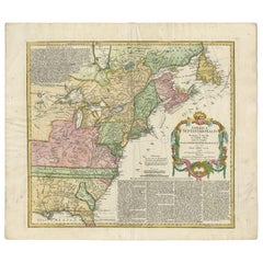
Antique Map of the British Colonies in North America by Homann Heirs, 1756
View Similar Items


Want more images or videos?
Request additional images or videos from the seller
1 of 6
Antique Map of the British Colonies in North America by Homann Heirs, 1756
About the Item
- Dimensions:Height: 21.07 in (53.5 cm)Width: 24.61 in (62.5 cm)Depth: 0.02 in (0.5 mm)
- Materials and Techniques:
- Period:
- Date of Manufacture:1756
- Condition:Please study image carefully.
- Seller Location:Langweer, NL
- Reference Number:Seller: D-01481stDibs: LU305439113141
About the Seller
5.0
Recognized Seller
These prestigious sellers are industry leaders and represent the highest echelon for item quality and design.
Gold Seller
Premium sellers maintaining a 4.3+ rating and 24-hour response times
Established in 2009
1stDibs seller since 2017
2,467 sales on 1stDibs
Typical response time: 1 hour
Authenticity Guarantee
In the unlikely event there’s an issue with an item’s authenticity, contact us within 1 year for a full refund. DetailsMoney-Back Guarantee
If your item is not as described, is damaged in transit, or does not arrive, contact us within 7 days for a full refund. Details24-Hour Cancellation
You have a 24-hour grace period in which to reconsider your purchase, with no questions asked.Vetted Professional Sellers
Our world-class sellers must adhere to strict standards for service and quality, maintaining the integrity of our listings.Price-Match Guarantee
If you find that a seller listed the same item for a lower price elsewhere, we’ll match it.Trusted Global Delivery
Our best-in-class carrier network provides specialized shipping options worldwide, including custom delivery.More From This Seller
View AllAntique Map of France by Homann Heirs, c.1745
Located in Langweer, NL
Antique map titled 'Gallia Postarum geographice designata in qua Cursus Postarum Secundum Statum (..)'. Unusual postal map of France, with coat of arms. Very detailed map showing all...
Category
Antique 18th Century Maps
Materials
Paper

$376 Sale Price
20% Off
Antique Map of Africa by Homann Heirs, '1804'
Located in Langweer, NL
Antique map titled 'Charte von Africa'. Large, original antique map of Africa by Franz Ludwig Güssefeld. Published by Homann Heirs, 1804.
Category
Antique Early 19th Century Maps
Materials
Paper

$1,410 Sale Price
20% Off
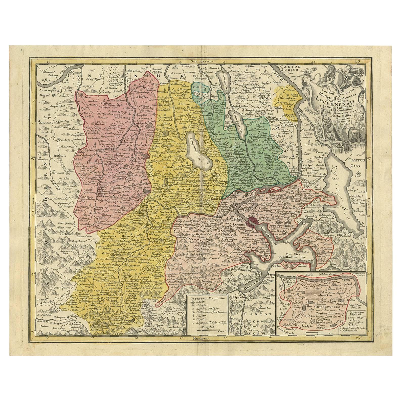
Antique Map of Switzerland by Homann Heirs, c.1732
Located in Langweer, NL
Antique map titled 'Potentissimae Helvetiorum Reipublicae (..)'. Beautiful detailed map of Switzerland, showing the 13 cantons. The large title cartouche showing 13 coat of arms of t...
Category
Antique 18th Century Maps
Materials
Paper

$366 Sale Price
20% Off
Antique Map of the Seventeen Provinces by Homann Heirs, 1748
By Homann Heirs
Located in Langweer, NL
Antique map titled 'Belgii Universi seu Inferioris Germaniae quam XVII Provinciae (..)'. Map of the Seventeen Provinces after Tobias Meier, published by Homann's Heirs in 1748. The S...
Category
Antique 18th Century Maps
Materials
Paper

$517 Sale Price
20% Off
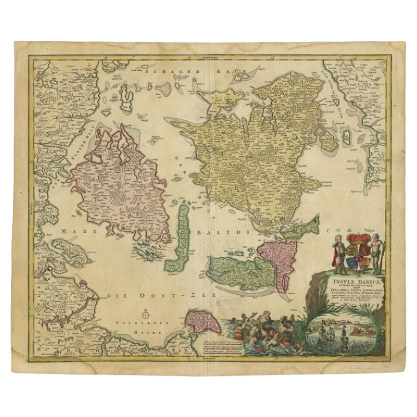
Antique Map of the Baltic Region by Homann Heirs, c.1730
Located in Langweer, NL
Antique map titled 'Regnum Borussiae gloriosis auspicijs Seerenissimi et Potentissimi Princip Friderici III (..).' Detailed map of the Baltic region from Memel to Pomerania, extendin...
Category
Antique 18th Century Maps
Materials
Paper
$437 Sale Price
20% Off
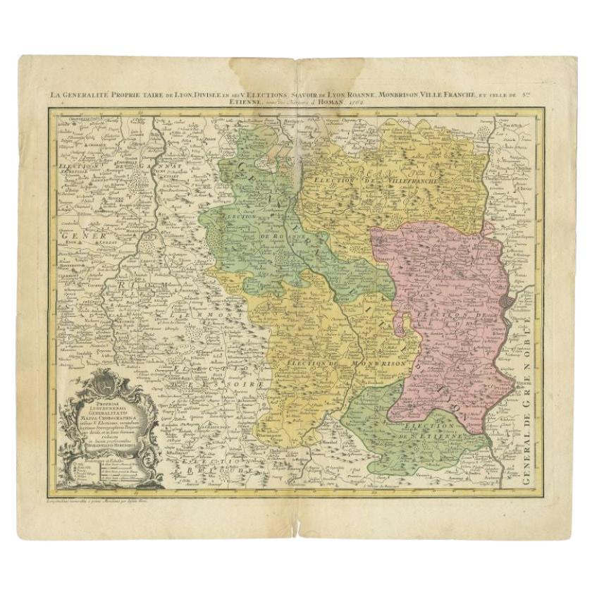
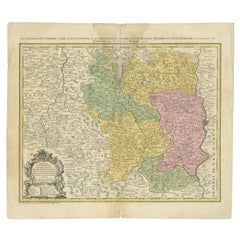
Antique Map of the Beaujolais Region by Homann Heirs, 1762
Located in Langweer, NL
Antique map titled 'La Generalite Proprie Taire De Lyon (..) - Propriae Lugudunensis Generalitatis (..)'. Detailed regional map of the Beaujolais region including the cities of Lyon,...
Category
Antique 18th Century Maps
Materials
Paper
$296 Sale Price
20% Off
You May Also Like
Original Antique Map of the American State of North Carolina, 1903
Located in St Annes, Lancashire
Antique map of North Carolina
Published By A & C Black. 1903
Original colour
Good condition
Unframed.
Free shipping
Category
Antique Early 1900s English Maps
Materials
Paper

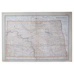
Original Antique Map of the American State of North Dakota, 1903
Located in St Annes, Lancashire
Antique map of North Dakota
Published By A & C Black. 1903
Original colour
Good condition
Unframed.
Free shipping
Category
Antique Early 1900s English Maps
Materials
Paper
1864 Map of North America, Antique Hand-Colored Map, by Adolphe Hippolyte Dufour
Located in Colorado Springs, CO
Offered is a map of North America entitled Amerique du Nord from 1864. This rare, separately published wall map was produced by Adolphe Hippolyte Dufour. This map includes vibrant an...
Category
Antique 1860s French Maps
Materials
Paper

New Map of North America from the Latest Discoveries, 1763
Located in Philadelphia, PA
A fine antique 18th century map of the North American seaboard.
Entitled "A New Map of North America from the Latest Discoveries 1763".
By the Cartographer/Engraver - John Spil...
Category
Antique Mid-18th Century English Georgian Maps
Materials
Paper

University Chart “Black Map of North America
Located in Godshill, Isle of Wight
University Chart “Black Map of North America
W&A K Johnston’s Charts of Physical Maps By G W Bacon,
This is a Black Physical map of North A...
Category
Early 20th Century Industrial Maps
Materials
Linen

1846 "North America" Map, Engraved by I. Dower
Located in Colorado Springs, CO
Presented is an original 1846 map of “North America.” The map was drawn and engraved by I. Dower and published in London by Orr & Company. The map depicts North America, to include G...
Category
Antique 1840s English Victorian Maps
Materials
Paper

Recently Viewed
View AllMore Ways To Browse
Classicon Munich
Colonial Brazil Dining Table Furniture
Convertible Chair Table
Corbusier Lc3 Sofa
Cordoba Silver
Corner Chesterfield
Cornucopia Fruit Basket
Costela Lounge Chair By Martin Eisler
Costela Rib Chair
Courting Flute
Cowan Ceramic
Cowan Deco
Cranberry Glass Jug
Cranberry Glass Pitcher
Cranberry Jug
Cranberry Swirl
Crescent Line Antique
Crystal Ashtray Stand