Items Similar to Grand Map of Europe by Frederick de Wit, Circa 1690: A Baroque Era Masterpiece.

Want more images or videos?
Request additional images or videos from the seller
1 of 7
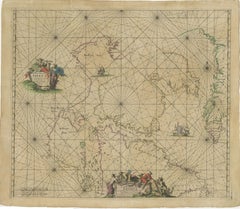
Grand Map of Europe by Frederick de Wit, Circa 1690: A Baroque Era Masterpiece.
About the Item
This is an attractive historical map of Europe created by Frederick de Wit, published around 1690. Here's a detailed description of the map and additional context about its creation:
### Description of the Map:
- **Geographical Coverage:** The map displays all of Europe, stretching from the Atlantic Ocean in the west to the Ural Mountains in the east. It includes parts of North Africa and the Middle East as well.
- **Details and Features:** The map is highly detailed, showing numerous cities, towns, and geographical features such as rivers, mountains, and forests. The level of detail indicates a significant amount of cartographic knowledge for the time.
- **Decorative Elements:** The map features a decorative cartouche in the top left corner. This cartouche includes the figure of "Europa" sitting on a bull, referencing the mythological story of Europa and the bull. This adds an artistic and mythological element to the map.
- **Sea Monsters and Ships:** The map also includes various sea monsters and ships in the surrounding waters, a common decorative element in maps of this era, adding to its visual appeal and historical interest.
- **Borders and Countries:** The borders of countries and regions are delineated, reflecting the political boundaries of the late 17th century.
### About the Maker:
- **Frederick de Wit:** Frederick de Wit was a prominent Dutch cartographer and engraver in the 17th century. Born in 1630 and passing away in 1706, de Wit was known for his high-quality maps and atlases.
- **Cartographic Contribution:** De Wit's work was highly regarded for its accuracy and artistic quality. His maps were detailed and often included decorative elements that made them both practical for navigation and attractive for display.
- **Atlas:** This particular map of Europe by Frederick de Wit is from his atlas titled "Atlas Maior." This atlas was one of de Wit's most significant works, containing a collection of detailed maps covering various parts of the world.
- **Publication Date:** The map was published around 1690, during the late Baroque period, a time when Dutch cartography was at its peak in terms of both scientific accuracy and artistic embellishment.
### Summary:
This map of Europe by Frederick de Wit from around 1690 is a highly detailed and decorative piece of cartography. It features artistic elements such as a mythological cartouche and sea monsters, reflecting the cartographic and artistic trends of the late 17th century. As part of de Wit's "Atlas Maior," it exemplifies the blend of scientific knowledge and artistic craftsmanship characteristic of Dutch cartography during this period.
- Dimensions:Height: 20.67 in (52.5 cm)Width: 25.2 in (64 cm)Depth: 0.02 in (0.5 mm)
- Materials and Techniques:
- Period:Late 17th Century
- Date of Manufacture:circa 1690
- Condition:Minor fading. Please study image carefully. Minor imperfections and some light toning due to handling and age. Folding line the middle as issued.
- Seller Location:Langweer, NL
- Reference Number:Seller: BG-091801stDibs: LU305439942251
About the Seller
5.0
Recognized Seller
These prestigious sellers are industry leaders and represent the highest echelon for item quality and design.
Gold Seller
Premium sellers maintaining a 4.3+ rating and 24-hour response times
Established in 2009
1stDibs seller since 2017
2,463 sales on 1stDibs
Typical response time: 1 hour
- ShippingRetrieving quote...Shipping from: Langweer, Netherlands
- Return Policy
Authenticity Guarantee
In the unlikely event there’s an issue with an item’s authenticity, contact us within 1 year for a full refund. DetailsMoney-Back Guarantee
If your item is not as described, is damaged in transit, or does not arrive, contact us within 7 days for a full refund. Details24-Hour Cancellation
You have a 24-hour grace period in which to reconsider your purchase, with no questions asked.Vetted Professional Sellers
Our world-class sellers must adhere to strict standards for service and quality, maintaining the integrity of our listings.Price-Match Guarantee
If you find that a seller listed the same item for a lower price elsewhere, we’ll match it.Trusted Global Delivery
Our best-in-class carrier network provides specialized shipping options worldwide, including custom delivery.More From This Seller
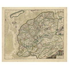
View AllAntique Map of Friesland by De Wit, c.1690
Located in Langweer, NL
Antique map titled 'Tabula Comitatus Frisiae'.
Old map of the province of Friesland, the Netherlands. With a small inset map of the Wadden area. Third state of the map by Schotan...
Category
Antique 17th Century Maps
Materials
Paper
$763 Sale Price
20% Off
Antique Map of Austria by F. de Wit, 1690
Located in Langweer, NL
Antique map titled 'Circuli Austriaci pars Septentrionalis in qua Archiducatus'. Decorative and detailed map of Austria by F. de Wit.
Category
Antique Late 17th Century Maps
Materials
Paper

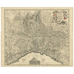
Antique Map of Northern Italy by F. de Wit, 1690
Located in Langweer, NL
A very decorative map centered on Genua, and including the towns of Milan, Torino, Parma, Cremona, etc. Decorative title cartouche upper right, five putti holding the arms of the reg...
Category
Antique Late 17th Century Maps
Materials
Paper
$512 Sale Price
20% Off
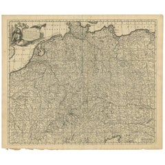
Antique Map of Central Europe "Centered on Germany" by F. de Wit, circa 1680
Located in Langweer, NL
A very detailed map of central Europe, centered on Germany. It extends from Belgium and The Netherlands through Pomerania in the north, and from eastern France to Croatia in the sout...
Category
Antique Late 17th Century Maps
Materials
Paper
$791 Sale Price
20% Off
1690 Frederick de Wit Sea Chart of Hudson Bay, Baffin Bay and Greenland
Located in Langweer, NL
Title: c. 1690 Frederick de Wit Sea Chart of Hudson Bay, Baffin Bay, and Greenland - Engraved by Romeyn de Hooghe
This striking sea chart by Frederick de Wit, titled "Septemtrionali...
Category
Antique 1690s Maps
Materials
Paper
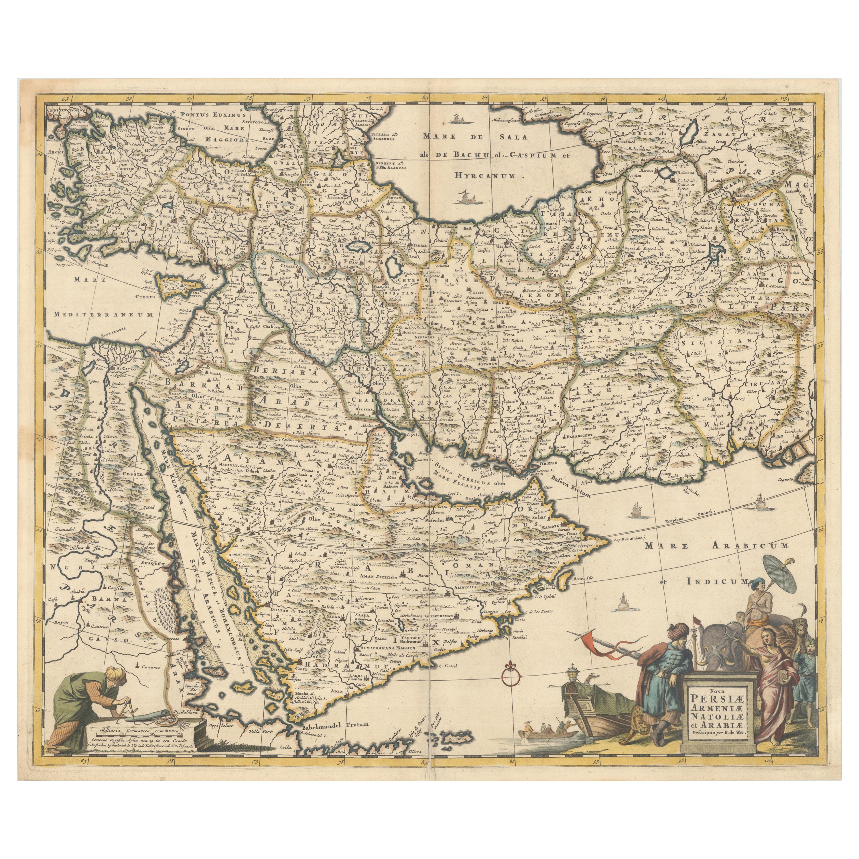
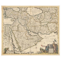
Circa 1691 Frederick de Wit Map: Middle East with Arabia, Persia & More
Located in Langweer, NL
Circa 1691 Frederick de Wit Map: Middle East with Arabia, Persia & More
This exquisite hand-colored map, circa 1691, by Frederick de Wit, illustrates the Middle East, spanning from Turkey and Egypt to Afghanistan, with a detailed representation of the Arabian Peninsula.
The map's detailing in Arabia is based on Nicolas Sanson's influential 1654 map, which was one of the most accurate and detailed depictions of the region up to the mid-seventeenth century.
The decorative title cartouche is richly adorned with images of exotic figures, animals, and a merchant ship, symbolizing the region's historical trade importance. Additionally, a mapmaker is shown working with traditional tools, adding a touch of authenticity to the cartographic art.
This is the fourth state of the map, published between 1691 and 1696. The map measures 21.8 inches in width by 18.5 inches in height, featuring a sharp impression, with minimal staining and a carefully repaired centerfold separation at the bottom.
Keywords:
- Middle East historical map
- Frederick de Wit map
- 17th century maps
- Arabian Peninsula map
- Persia (Iran) map
- Turkey and Egypt map...
Category
Antique 1690s Maps
Materials
Paper
$2,281 Sale Price
20% Off
You May Also Like
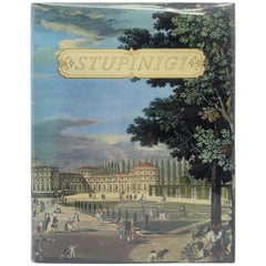
Stupinigi, a Masterpiece of 17th Century Europe Between Baroque and Classicism
Located in New York, NY
Stupinigi, a masterpiece of 17th century Europe between Baroque and classicism. The story and photos of the magnificent hunting palace of the kings of Italy. First edition hardcover,...
Category
Mid-20th Century Italian Books
Materials
Paper
Persia, Armenia & Adjacent Regions: A 17th Century Hand-colored Map by De Wit
By Frederick de Wit
Located in Alamo, CA
A large 17th century hand colored copperplate engraved map entitled "Novissima nec non Perfectissima Scandinaviae Tabula comprehendens Regnorum Sueciae, Daniae et Norvegiae distincte...
Category
Antique Late 17th Century Dutch Maps
Materials
Paper

Large 17th Century Hand Colored Map of England and the British Isles by de Wit
By Frederick de Wit
Located in Alamo, CA
A large hand colored 17th century map of England and the British Isles by Frederick de Wit entitled "Accuratissima Angliæ Regni et Walliæ Principatus", published in Amsterdam in 1680. It is a highly detailed map of England, Scotland, the Scottish Isles...
Category
Antique Late 17th Century Dutch Maps
Materials
Paper

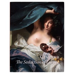
Exhibition, Casanovia; Seduction of Europe, by Frederick Ilchman, Stated 1st Ed
Located in valatie, NY
Casanovia; Seduction of Europe, by Frederick Ilchman. MFA Publications, Museum of fine Arts, Boston, 2017. 1st Ed hardcover with dust jacket. From the salon to the boudoir: the world...
Category
21st Century and Contemporary American Books
Materials
Paper
Original Antique Map of Europe, Arrowsmith, 1820
Located in St Annes, Lancashire
Great map of Europe
Drawn under the direction of Arrowsmith.
Copper-plate engraving.
Published by Longman, Hurst, Rees, Orme and Brown, 1820
...
Category
Antique 1820s English Maps
Materials
Paper

Large Original Antique Map of Europe by Sidney Hall, 1847
Located in St Annes, Lancashire
Great map of Europe
Drawn and engraved by Sidney Hall
Steel engraving
Original colour outline
Published by A & C Black. 1847
Unframed
Free shipping.
Category
Antique 1840s Scottish Maps
Materials
Paper

Recently Viewed
View AllMore Ways To Browse
Dairy Bowl
Dairy Table
Danish Cocktail Shaker
Danish Library Desk
Danish Maple Lounge Chairs
Danish Oil Paintings Of Cows
Dansk Flatware Vintage
Davenport Chinoiserie
De Sede 140
De Sede Ds 31
De Sede Ds31
De Sede Rh 305
Decanters Palda
Demitasse Cups Service
Derby Bloor
Desk Beurdeley
Desk With Slate Top
Dexter Brown