Items Similar to Antique Map of France at the End of the Reign of Jean II by Zannoni, 1765
Want more images or videos?
Request additional images or videos from the seller
1 of 5
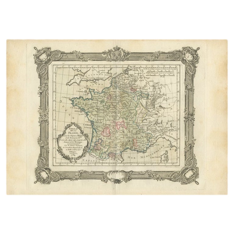
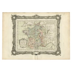
Antique Map of France at the End of the Reign of Jean II by Zannoni, 1765
About the Item
Antique map France titled 'La France sous la fin du Regne de Jean II (..)'. Beautiful old map of France. This map originates from 'Atlas Historique de la France Ancienne et Moderne' by M. Rizzi Zannoni.
Artists and Engravers: Published by S. Desons, Paris. Giovanni Rizzi Zannoni (1736-1814 ) was an Italian cartographer and geographer.
Condition: Very good, please study image carefully.
Date: 1765
Overall size: 40 x 28 cm.
Image size: 30 x 24 cm.
We sell original antique maps to collectors, historians, educators and interior decorators all over the world. Our collection includes a wide range of authentic antique maps from the 16th to the 20th centuries. Buying and collecting antique maps is a tradition that goes back hundreds of years. Antique maps have proved a richly rewarding investment over the past decade, thanks to a growing appreciation of their unique historical appeal. Today the decorative qualities of antique maps are widely recognized by interior designers who appreciate their beauty and design flexibility. Depending on the individual map, presentation, and context, a rare or antique map can be modern, traditional, abstract, figurative, serious or whimsical. We offer a wide range of authentic antique maps for any budget.
- Creator:G. A. Rizzi-zannoni (Artist)
- Dimensions:Height: 11.03 in (28 cm)Width: 15.75 in (40 cm)Depth: 0 in (0.01 mm)
- Materials and Techniques:
- Period:
- Date of Manufacture:1765
- Condition:
- Seller Location:Langweer, NL
- Reference Number:Seller: BG-11796-291stDibs: LU3054326190952
About the Seller
5.0
Recognized Seller
These prestigious sellers are industry leaders and represent the highest echelon for item quality and design.
Gold Seller
Premium sellers maintaining a 4.3+ rating and 24-hour response times
Established in 2009
1stDibs seller since 2017
2,467 sales on 1stDibs
Typical response time: 1 hour
- ShippingRetrieving quote...Shipping from: Langweer, Netherlands
- Return Policy
Authenticity Guarantee
In the unlikely event there’s an issue with an item’s authenticity, contact us within 1 year for a full refund. DetailsMoney-Back Guarantee
If your item is not as described, is damaged in transit, or does not arrive, contact us within 7 days for a full refund. Details24-Hour Cancellation
You have a 24-hour grace period in which to reconsider your purchase, with no questions asked.Vetted Professional Sellers
Our world-class sellers must adhere to strict standards for service and quality, maintaining the integrity of our listings.Price-Match Guarantee
If you find that a seller listed the same item for a lower price elsewhere, we’ll match it.Trusted Global Delivery
Our best-in-class carrier network provides specialized shipping options worldwide, including custom delivery.More From This Seller
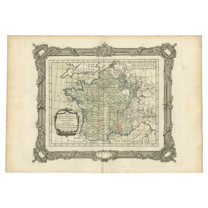
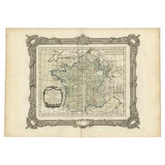
View AllAntique Map of France at the end of the Reign of Louis the Great by Zannoni 1765
By G. A. Rizzi-zannoni
Located in Langweer, NL
Antique map France titled 'Etat de la France à la fin du Règne de Louis le Grand (..)'. Beautiful old map of France. This map originates from 'Atlas Historique de la France Ancienne ...
Category
Antique 18th Century Maps
Materials
Paper
$167 Sale Price
20% Off
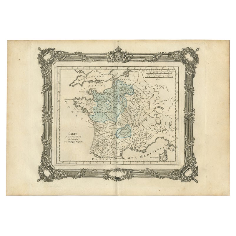
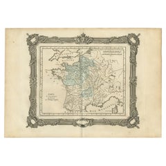
Antique Map of France under the Reign of Philip II by Zannoni, 1765
Located in Langweer, NL
Antique map France titled 'Carte de l'accroissement du Domaine sous Philippe Auguste (..)'. Beautiful old map of France. This map originates from 'Atlas Historique de la France Ancie...
Category
Antique 18th Century Maps
Materials
Paper
$137 Sale Price
20% Off
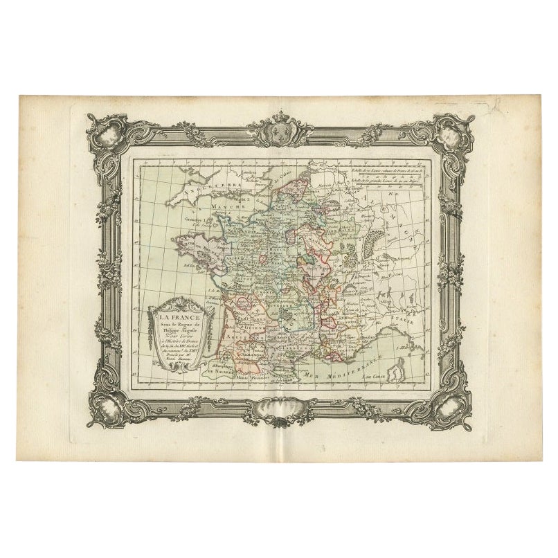
Antique Map of France under the Reign of Philip II by Zannoni, 1765
Located in Langweer, NL
Antique map France titled 'La France sous les Regne de Philippe Auguste (..)'.
Beautiful old map of France. This map originates from 'Atlas Historique de la France Ancienne et Mo...
Category
Antique 18th Century Maps
Materials
Paper
$146 Sale Price
20% Off
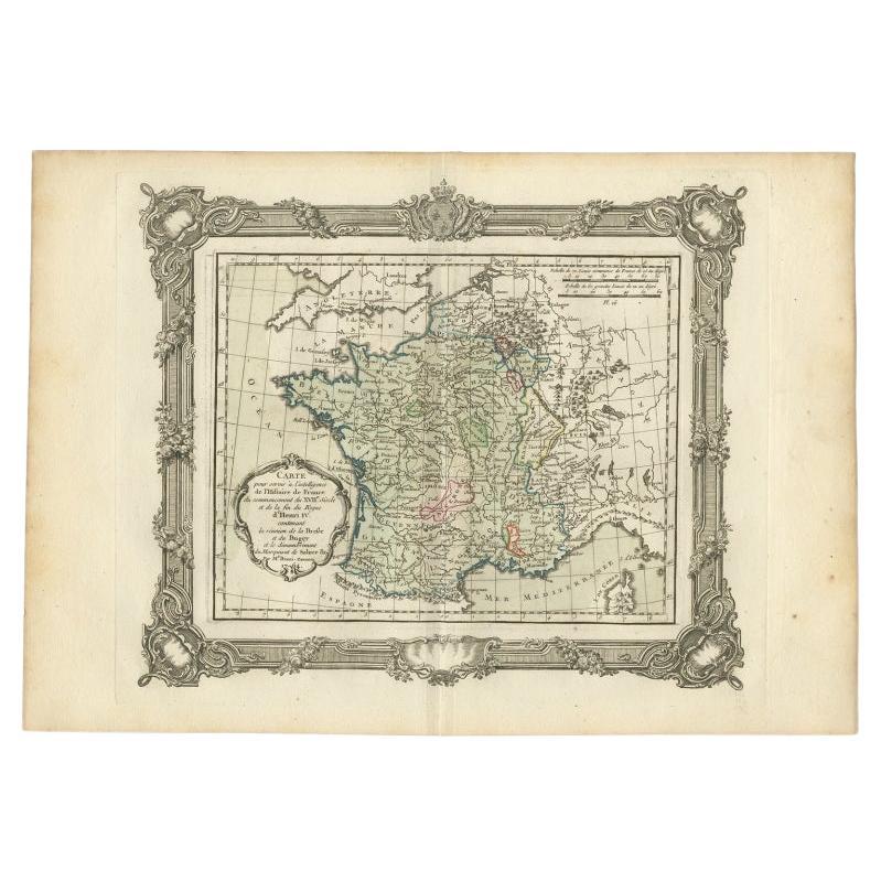
Antique Map of France at the Beginning of the 17th Century by Zannoni, 1765
By G. A. Rizzi-zannoni
Located in Langweer, NL
Antique map France titled 'Carte pour servir à intelligence de l'Histoire de France (..)'. Beautiful old map of France. This map originates from 'At...
Category
Antique 18th Century Maps
Materials
Paper
$147 Sale Price
20% Off
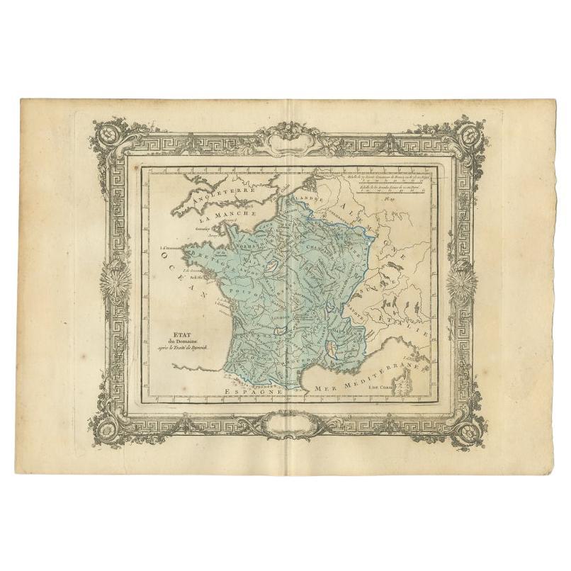
Antique Map of France After the Peace of Ryswick by Zannoni, 1765
By G. A. Rizzi-zannoni
Located in Langweer, NL
Antique map France titled 'Etat du Domaine apès le Traité de Ryswick (..)'. Beautiful old map of France. This map originates from 'Atlas Historique de la France Ancienne et Moderne' ...
Category
Antique 18th Century Maps
Materials
Paper

$137 Sale Price
20% Off
Antique Map of France under the Reign of Henry and Francois II by Zannoni, 1765
Located in Langweer, NL
Antique map France titled 'Tableau de la France sous les Règnes d'Henri (..)'. Beautiful old map of France. This map originates from 'Atlas Historique de la France Ancienne et Modern...
Category
Antique 18th Century Maps
Materials
Paper
$147 Sale Price
20% Off
You May Also Like
1812 United States Map, by Pierre Tardieu, Antique French Map Depicting the U.S.
By Pierre François Tardieu
Located in Colorado Springs, CO
1812 "United States of Nth America -- Carte des Etats-Unis De L'Amerique Septentrionale" Two-Sheet Map by Tardieu
This attractive map, published in Paris in 1812, is one of the most rare large format maps from the period. It features a view of the East Coast of the U.S. from Maryland to just below South Carolina. Additionally, Ellicott’s plan for the City of Washington D.C. is included at the top right and an illustration of Niagara Falls is shown at the bottom right with a description in both French and English. This extremely detailed map not only depicts the mountainous regions of the southeastern U.S., but also includes names of regions, rivers, and towns.
Based on the first state of Arrowsmith’s 4-sheet map of the United States, this map is completely engraved by Tardieu in Paris and showcases high quality engravings. This detailed map of the recently independent United States includes one of the largest and earliest examples of the Ellicott plan of Washington DC.
The artist, Pierre François Tardieu (PF Tardieu) was a very well-known map engraver, geographer, and illustrator. Awarded a bronze medal by King Louis-Phillipe for the accuracy and beauty of his map-making, Tardieu produced many fine works including maps of Louisiana...
Category
Antique 1810s French Maps
Materials
Paper

The Holy Land at the Time of Jesus: A 17th Century Dutch Map by Visscher
By Nicolaes Visscher II
Located in Alamo, CA
This detailed Dutch map entitled "Het Beloofe de Landt Canaan door wandelt van onsen Salichmaecker Iesu Christo, nessens syne Apostelen" by Nicolaes Visscher was published in Amsterd...
Category
Antique Mid-17th Century Dutch Maps
Materials
Paper

Plan of Paris, France, by A. Vuillemin, Antique Map, 1845
Located in Colorado Springs, CO
This large and detailed plan of Paris was published by Alexandre Vuillemin in 1845. The map conveys a wonderful amount of information and is decorated throughout with pictorial vigne...
Category
Antique 1840s American Maps
Materials
Paper

Original Antique Map of The Philippines. C.1900
Located in St Annes, Lancashire
Fabulous map of The Philippines
Original color.
Engraved and printed by the George F. Cram Company, Indianapolis.
Published, C.1900.
Unframed.
Free shipping.
Category
Antique 1890s American Maps
Materials
Paper

Original Antique Map of The World by Thomas Clerk, 1817
Located in St Annes, Lancashire
Great map of The Eastern and Western Hemispheres
On 2 sheets
Copper-plate engraving
Drawn and engraved by Thomas Clerk, Edinburgh.
Published by Mackenzie And Dent, 1817
...
Category
Antique 1810s English Maps
Materials
Paper

Super Rare Antique French Map of Chine and the Chinese Empire, 1780
Located in Amsterdam, Noord Holland
Super Rare Antique French Map of Chine and the Chinese Empire, 1780
Very nice map of Asia. 1780 Made by Bonne.
Additional information:
Type: Map
...
Category
Antique 18th Century European Maps
Materials
Paper

$584 Sale Price
31% Off
Recently Viewed
View AllMore Ways To Browse
Vintage Yellow Formica Table
Vintage Chocolate Posters
Vitra Meda Chair
Vitra Soft Pad
Vladimir Kagan Bench
Vladimir Kagan Console
Walnut Cane Desk Chair
Walnut Library Ladder
Warren Platner Style Coffee Table
Wassily Style Leather Chair Marcel Breuer
Wedgwood Majolica Green Plate
West Side Story Vintage Poster
Whale Engraving
Wharton Esherick Stool
White Bamboo Shelf
White Footed Fruit Bowl
Wicker Trunks
Widdicomb Origins