Items Similar to Antique Map of France by Faden, 1792

Want more images or videos?
Request additional images or videos from the seller
1 of 5
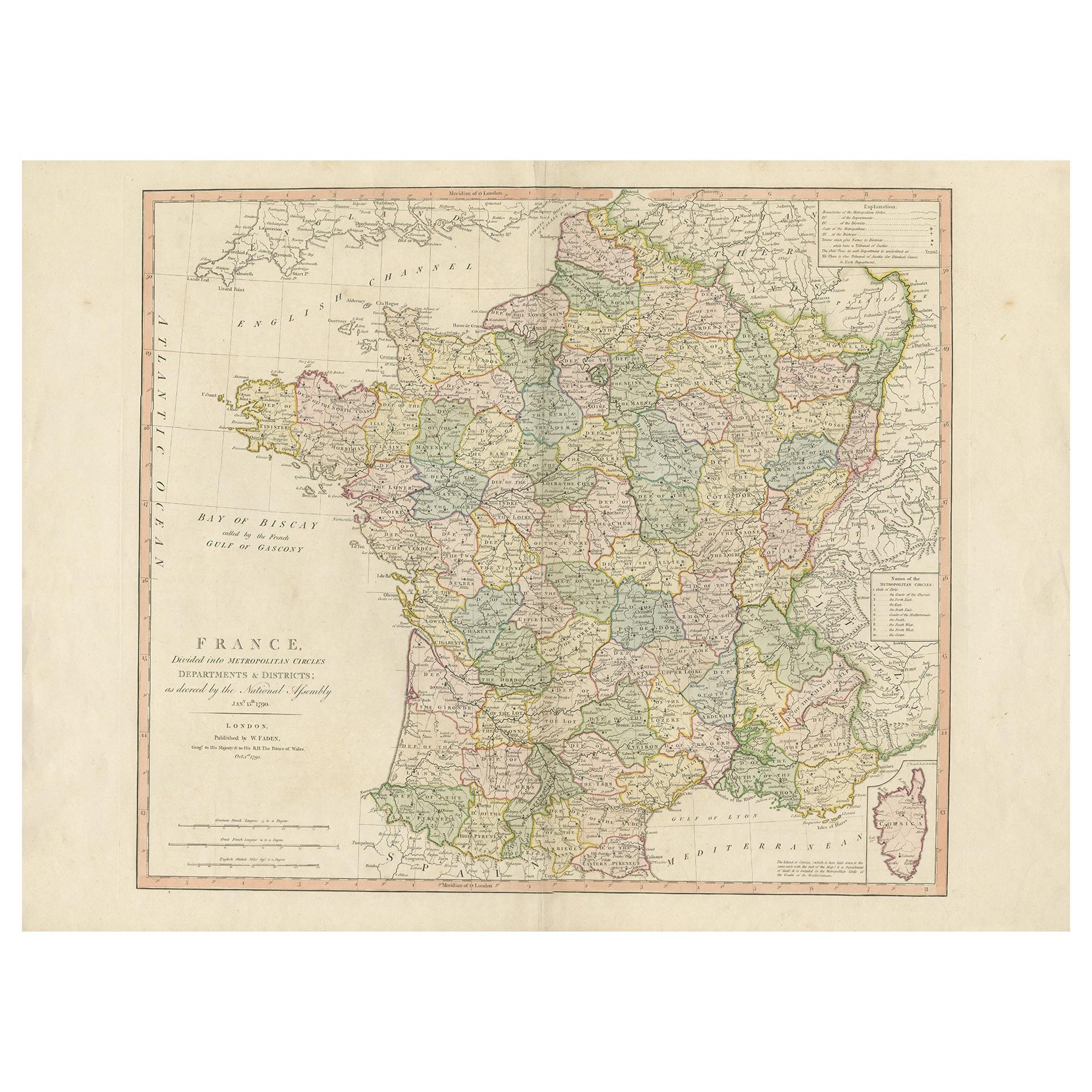
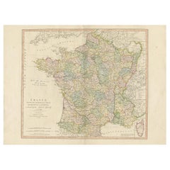
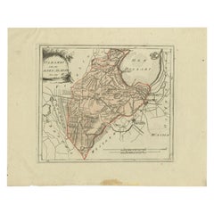
Antique Map of France by Faden, 1792
About the Item
Antique map titled 'France divided into Metropolitan Circles (..)'. Large, original antique map of France, with a small inset of the island of Corsica. Published by W. Faden, 1792.
Artists and Engravers: William Faden (1749-1836) was the most prominent London mapmaker and publisher of the late-eighteenth and early-nineteenth centuries. His father, William Mackfaden, was a printer who dropped the first part of his last name due to the Jacobite rising of 1745.
Condition: Very good, original/contemporary coloring. Original folding line. Minor wear, blank verso. Please study image carefully.
Date: 1792
Overall size: 78 x 55 cm.
Image size: 0.001 x 62 x 52.5 cm.
- Dimensions:Height: 21.66 in (55 cm)Width: 30.71 in (78 cm)Depth: 0 in (0.01 mm)
- Materials and Techniques:
- Period:
- Date of Manufacture:1792
- Condition:
- Seller Location:Langweer, NL
- Reference Number:
About the Seller
5.0
Platinum Seller
These expertly vetted sellers are 1stDibs' most experienced sellers and are rated highest by our customers.
Established in 2009
1stDibs seller since 2017
1,928 sales on 1stDibs
Typical response time: <1 hour
- ShippingRetrieving quote...Ships From: Langweer, Netherlands
- Return PolicyA return for this item may be initiated within 14 days of delivery.
More From This SellerView All
- Antique Map of France by Faden '1792'Located in Langweer, NLAntique map titled 'France divided into Metropolitan Circles (..)'. Large, original antique map of France, with a small inset of the island of Co...Category
Antique Late 18th Century Maps
MaterialsPaper
- Antique Hand-Colored Map of France by J.B. Elwe, 1792Located in Langweer, NLAntique map titled 'Carte Nouvelle du Royaume de France'. Beautiful antique map of France, including the Southern part of England. Decorated with cartouche and 12 coats of arms.Category
Antique Late 18th Century Maps
MaterialsPaper
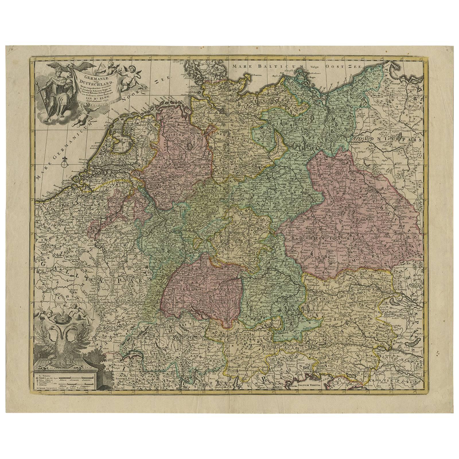
- Antique Map of Germany by J.B. Elwe, 1792Located in Langweer, NLAntique map titled 'Germanie vulgo Duitschland (..)'. Decorative map of Germany with Silesia, Bohemia , Netherlands, Belgium, Elzas, Switzerland, Tyrol and Austria. With two cartouch...Category
Antique Late 18th Century Maps
MaterialsPaper
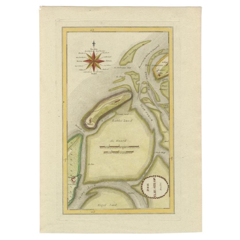
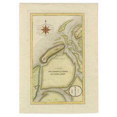
- Antique Map of the Wadden Islands, 1792Located in Langweer, NLAntique map titled 'Der Vlie Strom'. Map of the Wadden islands with Vlieland in the middle (The Netherlands). This map originates from 'Schauplatz der fünf Theile der Welt' published...Category
Antique 18th Century Maps
MaterialsPaper
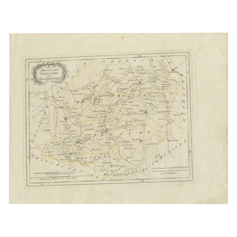
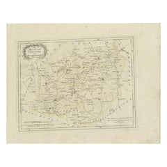
- Antique Map of Part of Overijssel by Von Reilly, 1792Located in Langweer, NLAntique map titled 'Das Drostamt Twenthe und Haarbergen'. This map depicts part of The Netherlands (Overijssel). This map originates from 'Schauplatz der fünf Theile der Welt' publis...Category
Antique 18th Century Maps
MaterialsPaper
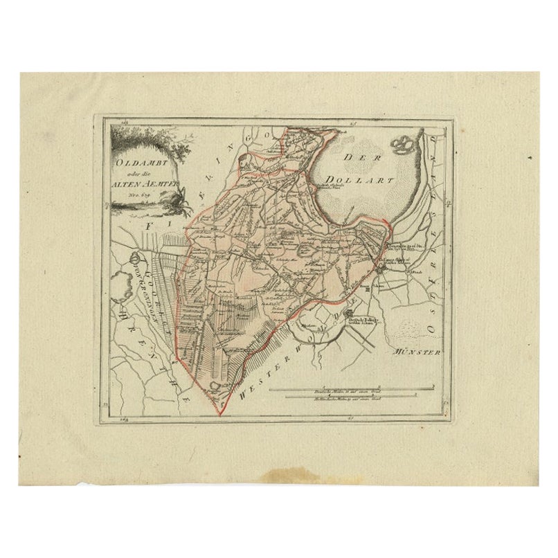
- Antique Map of Part of Groningen by Von Reilly, 1792Located in Langweer, NLAntique map titled 'Oldambt oder die Alten Aemter'. This map depicts part of the Dutch province Groningen. This map originates from 'Schauplatz der fünf Theile der Welt' published in...Category
Antique 18th Century Maps
MaterialsPaper


You May Also Like
- Plan of Paris, France, by A. Vuillemin, Antique Map, 1845Located in Colorado Springs, COThis large and detailed plan of Paris was published by Alexandre Vuillemin in 1845. The map conveys a wonderful amount of information and is decorated throughout with pictorial vigne...Category
Antique 1840s American Maps
MaterialsPaper
- Original Antique Map of France, Arrowsmith, 1820Located in St Annes, LancashireGreat map of France Drawn under the direction of Arrowsmith. Copper-plate engraving. Published by Longman, Hurst, Rees, Orme and Brown, 1820 Unframed.Category
Antique 1820s English Maps
MaterialsPaper
- 1861 Topographical Map of the District of Columbia, by Boschke, Antique MapLocated in Colorado Springs, COPresented is an original map of Albert Boschke's extremely sought-after "Topographical Map of the District of Columbia Surveyed in the Years 1856 ...Category
Antique 1860s American Historical Memorabilia
MaterialsPaper
- 1907 Map of Colorado, Antique Topographical Map, by Louis NellLocated in Colorado Springs, COThis highly detailed pocket map is a topographical map of the state of Colorado by Louis Nell from 1907. The map "has been complied from all availabl...Category
Antique Early 1900s American Maps
MaterialsPaper
- Original Large Antique Map of Paris, France by John Dower, 1861Located in St Annes, LancashireFabulous monochrome map of Paris. Vignettes of St Germain En Laye, Saint Cloud, Versailles and Fontainbleau. Unframed. Drawn by J.Dower. Lithography by Weller. 4 sheets j...Category
Antique 1860s English Victorian Maps
MaterialsPaper
- Antique Map of Italy by Andriveau-Goujon, 1843By Andriveau-GoujonLocated in New York, NYAntique Map of Italy by Andriveau-Goujon, 1843. Map of Italy in two parts by Andriveau-Goujon for the Library of Prince Carini at Palazzo Carini i...Category
Antique 1840s French Maps
MaterialsLinen, Paper


Recently Viewed
View AllMore Ways To Browse
Antique Large Island
French Antique Island
Map London
Maps London
London Map
Map Of London
Eighteenth Century French Furniture
Antique Maps Of London
Antique Map Of London
Antique French Divider
1836 Antiques
Antique French 18th Century Map
Large Map Of London
Antique Jacobite
Antique Maps Of London
Antique Map Of London
Antique Maps Amsterdam
Antique And Collectable Fairs