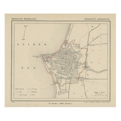
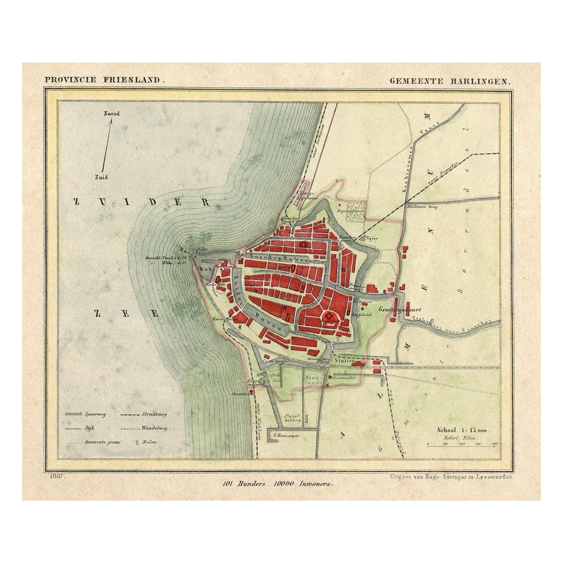
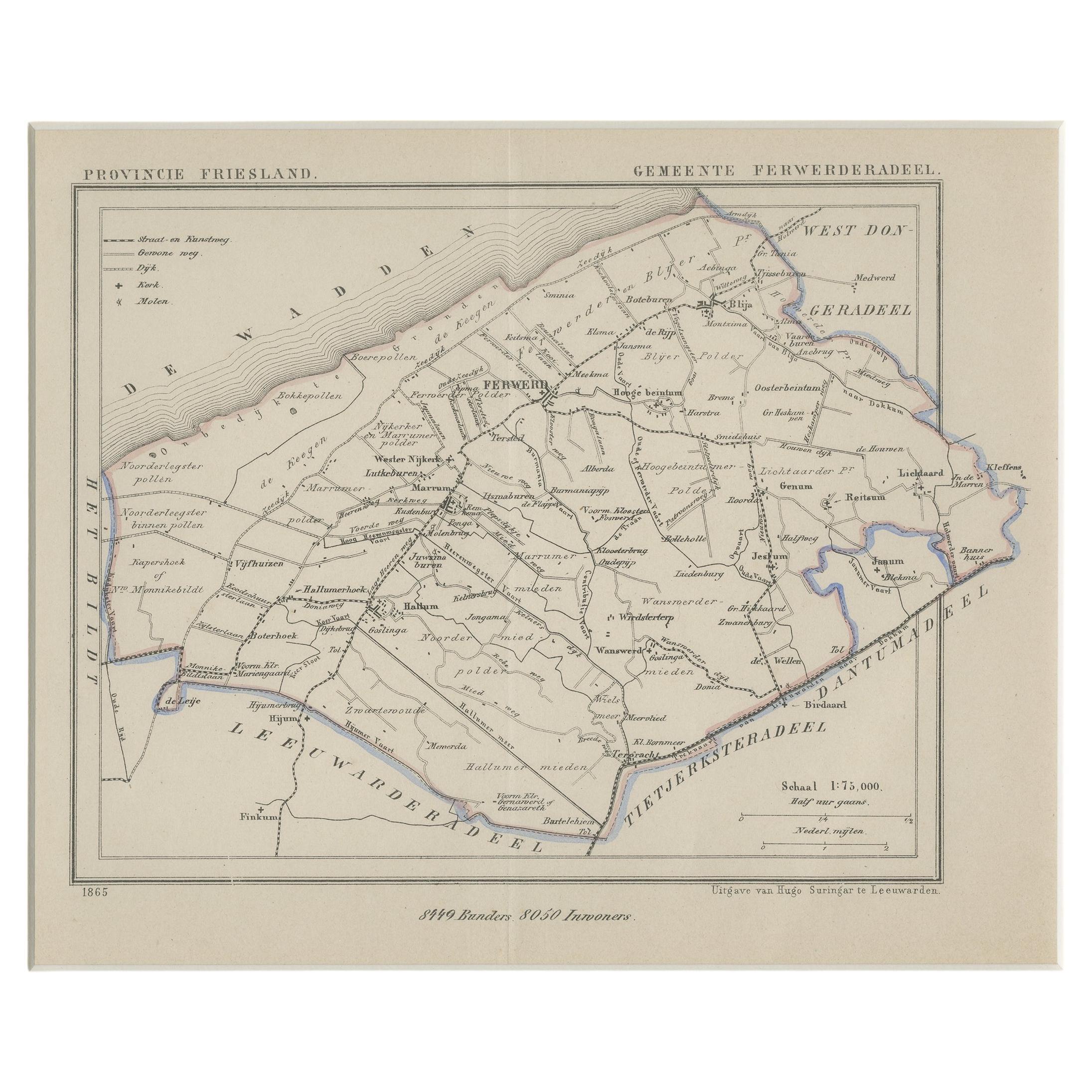
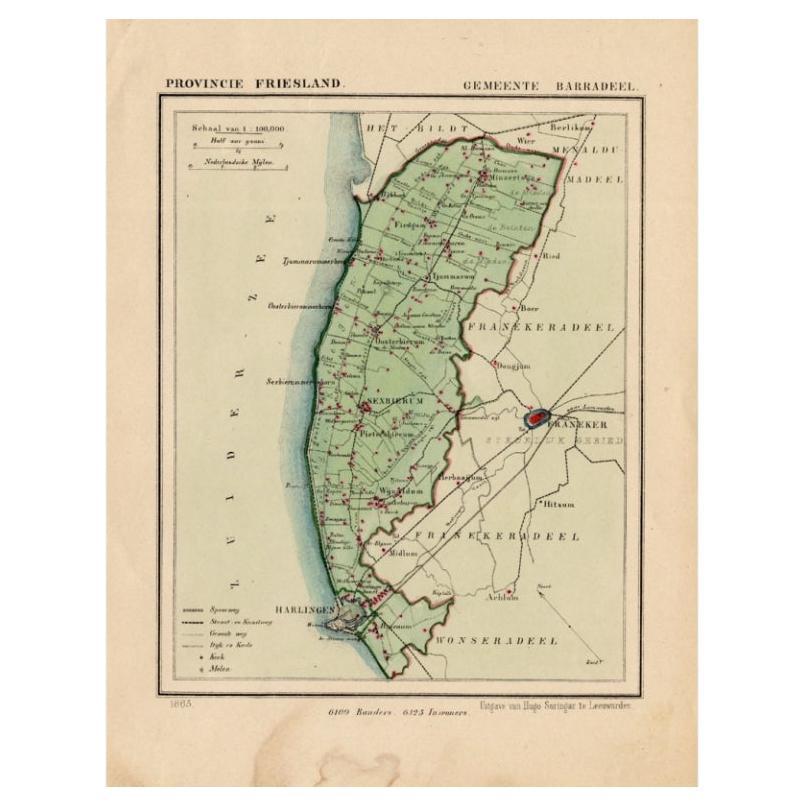
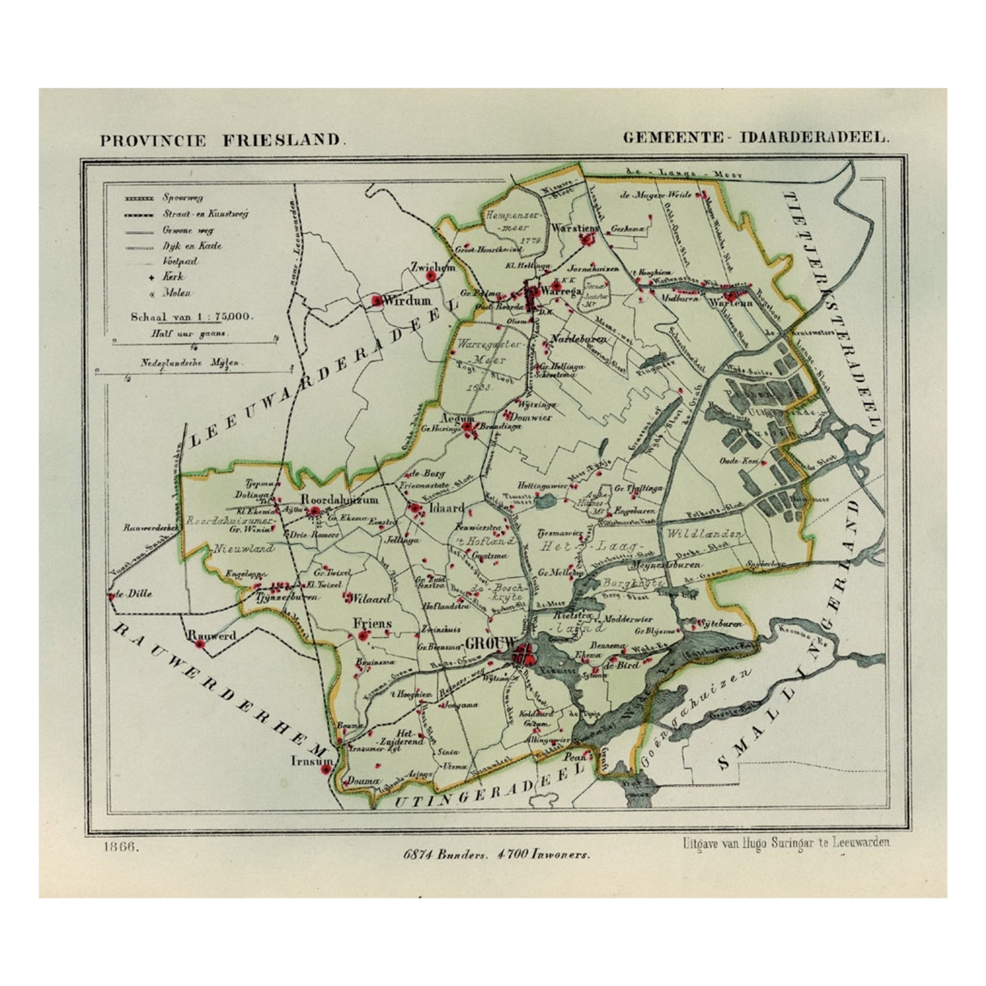
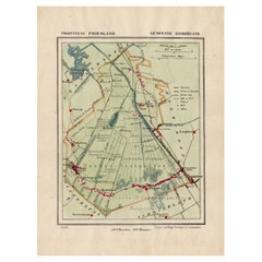
Antique Map of Harlingen, Harbour in Friesland, The Netherlands, 1868
View Similar Items
Want more images or videos?
Request additional images or videos from the seller
1 of 5
Antique Map of Harlingen, Harbour in Friesland, The Netherlands, 1868
About the Item
- Dimensions:Height: 10.44 in (26.5 cm)Width: 7.88 in (20 cm)Depth: 0 in (0.01 mm)
- Materials and Techniques:
- Period:
- Date of Manufacture:1868
- Condition:
- Seller Location:Langweer, NL
- Reference Number:Seller: BG-04638-181stDibs: LU3054326574672
About the Seller
5.0
Recognized Seller
These prestigious sellers are industry leaders and represent the highest echelon for item quality and design.
Gold Seller
Premium sellers maintaining a 4.3+ rating and 24-hour response times
Established in 2009
1stDibs seller since 2017
2,464 sales on 1stDibs
Typical response time: 1 hour
Authenticity Guarantee
In the unlikely event there’s an issue with an item’s authenticity, contact us within 1 year for a full refund. DetailsMoney-Back Guarantee
If your item is not as described, is damaged in transit, or does not arrive, contact us within 7 days for a full refund. Details24-Hour Cancellation
You have a 24-hour grace period in which to reconsider your purchase, with no questions asked.Vetted Professional Sellers
Our world-class sellers must adhere to strict standards for service and quality, maintaining the integrity of our listings.Price-Match Guarantee
If you find that a seller listed the same item for a lower price elsewhere, we’ll match it.Trusted Global Delivery
Our best-in-class carrier network provides specialized shipping options worldwide, including custom delivery.More From This Seller
View AllAntique Map of Harlingen, a Harbour City in Friesland, The Netherlands, 1868
Located in Langweer, NL
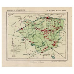
Antique map titled 'Provincie Friesland - Gemeente Harlingen'.
Map of the township of Harlingen, Friesland. This map originates from 'Gemeente-Atlas van Nederland' by J. Kuyper. ...
Category
Antique 19th Century Maps
Materials
Paper

$130 Sale Price
20% Off
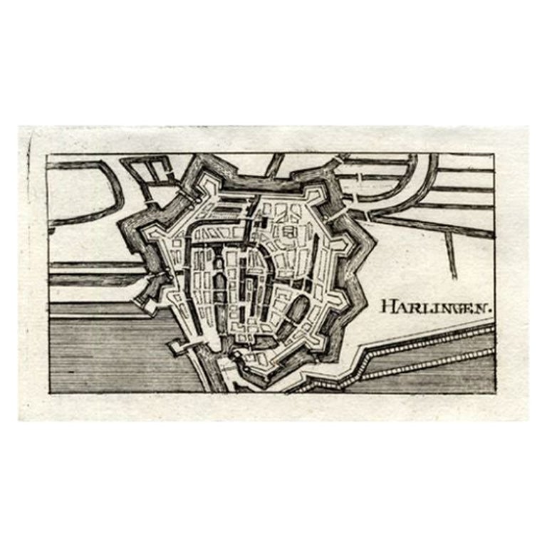
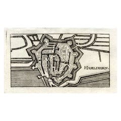
Antique Map of Harlingen, Harbour City in the Netherlands, 1691
Located in Langweer, NL
Plate 'Harlingen.' (Plan of the city of Harlingen, The Netherlands.) This attractive original old antique print / plate originates from: 'Ausführliche und grundrichtige Beschreibung ...
Category
Antique 17th Century Maps
Materials
Paper
$130 Sale Price
20% Off
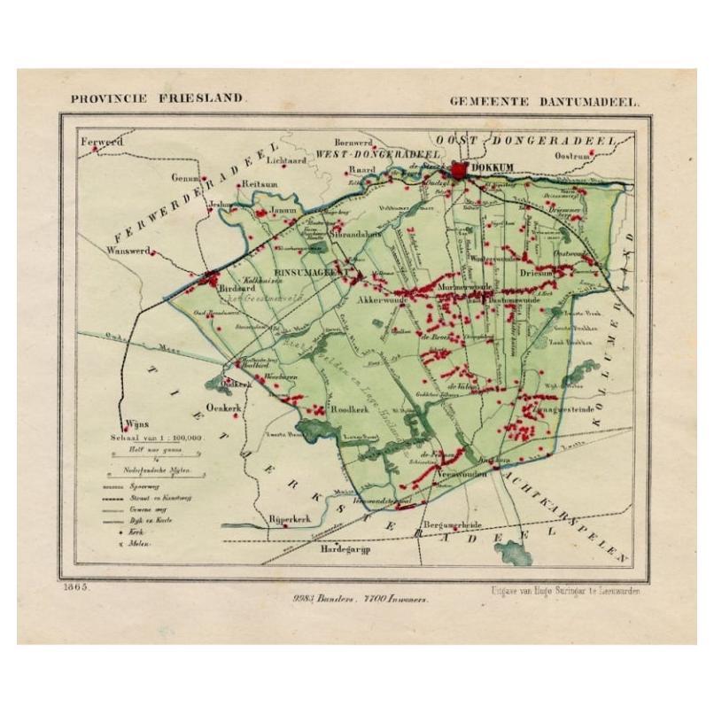
Antique Map of Dantumadeel, Friesland, The Netherlands, 1868
Located in Langweer, NL
Antique map titled 'Provincie Friesland - Gemeente Dantumadeel'. Map of the township of Dantumadeel including Birdaard, Rinsumageest, Veenwouden and many other villages. This map ori...
Category
Antique 19th Century Maps
Materials
Paper
$100 Sale Price
20% Off
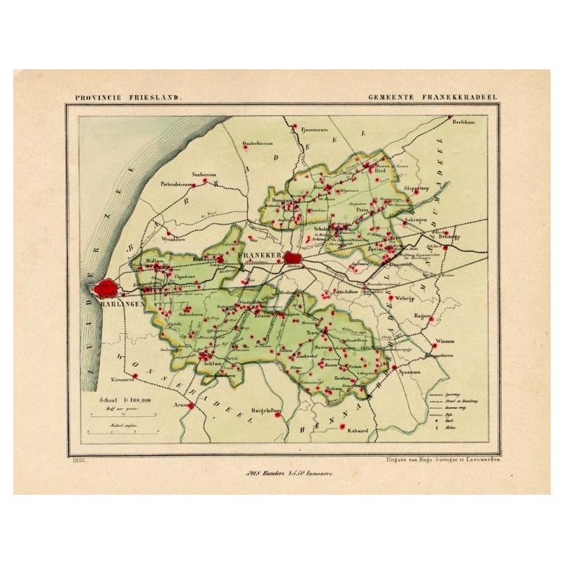
Antique Map of Franekeradeel, Township in Friesland, The Netherlands, 1868
Located in Langweer, NL
Antique map titled 'Provincie Friesland - Gemeente Franekeradeel'.
Map of the township of Franekeradeel including Franeker, Achlum, Dongjum, Midlum and many other villages. This ...
Category
Antique 19th Century Maps
Materials
Paper

$120 Sale Price
20% Off
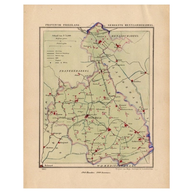
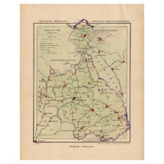
Antique Map of Hennaarderadeel, Township in Friesland, The Netherlands, 1868
Located in Langweer, NL
Antique map titled 'Provincie Friesland - Gemeente Hennaarderadeel'.
Map of the township of Hennarderadeel including Oosterend, Wommels and many other villages. This map originat...
Category
Antique 19th Century Maps
Materials
Paper
$120 Sale Price
20% Off
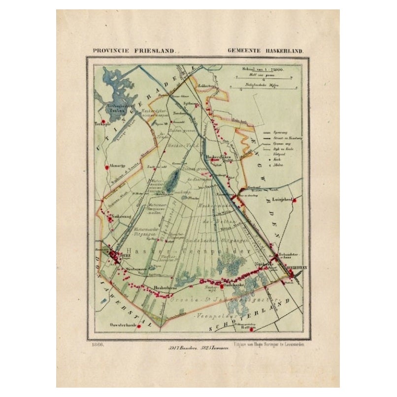
Antique Map of Haskerland, Township in Friesland, The Netherlands, 1868
Located in Langweer, NL
Antique map titled 'Provincie Friesland - Gemeente Haskerland'.
Map of the township of Haskerland including Haskerhorne, Joure, Oudehaske and many other villages. This map origin...
Category
Antique 19th Century Maps
Materials
Paper
$120 Sale Price
20% Off
You May Also Like
1868 "Lloyd's Topographical Railway Map of North America..." Hanging Wall Map
Located in Colorado Springs, CO
Presented is “Lloyd's Topographical Railway Map of North-America, or the United States Continent in 1900.” This map was published by J. T. Lloyd, in New York, in 1868. A large, hangi...
Category
Antique 1860s American Late Victorian Maps
Materials
Linen, Paper

1868 Map of the Upper Part of the Island of Manhattan Above 86th Street
By Wm. Rogers Mfg. Co.
Located in San Francisco, CA
This wonderful piece of New York City history is over 150 years old. It depicts 86th street and above. It was lithographed by WC Rogers and company. It was made to show what was the Battle of Harlem during the Revolutionary war...
Category
Antique 1860s American American Colonial Maps
Materials
Paper

1868 The Moonstone
By Wilkie Collins
Located in Bath, GB
A beautiful first edition set of Wilkie Collin's important sensation mystery novel, very scarce to see a set of all first editions volumes.
The sought after first edition, first sta...
Category
Antique 1860s British Books
Materials
Paper
$16,439
1752 Vaugoundy Map of Flanders : Belgium, France, and the Netherlands, Ric.a002
Located in Norton, MA
Large Vaugoundy Map of Flanders:
Belgium, France, and the Netherlands
Colored -1752
Ric.a002
Description: This is a 1752 Didier Robert de Vaugondy map of Flanders. The map de...
Category
Antique 17th Century Unknown Maps
Materials
Paper

Original Antique Map of The Philippines. C.1900
Located in St Annes, Lancashire
Fabulous map of The Philippines
Original color.
Engraved and printed by the George F. Cram Company, Indianapolis.
Published, C.1900.
Unframed.
Free shipping.
Category
Antique 1890s American Maps
Materials
Paper

Chart of the Harbour of Liverpool
Located in Cheshire, GB
PL Burdett A Chart of the Harbour of Liverpool hand coloured. Encased in an ebonised frame.
Dimensions
Height 23.5 Inches
Width 28 Inches
Depth 1 Inches
Category
Early 20th Century British Maps
Materials
Paper

Recently Viewed
View AllMore Ways To Browse
Asian Canopy Bed
Asko Bonanza
Astro Table
Audoux Minet Rope Stool
Australian Daybill
B B Italia Outdoor
Baccarat Candy
Baccarat Cut Glass Box
Baccarat Ruby
Bachelor Teapot
Backstrom Ljungberg
Bakelite Radios
Baker Barrel Chairs
Baker Chinoiserie Chair
Baker Chippendale Chair
Baker Demilune
Baker Flip Top
Baker Furniture Chippendale Chair