Items Similar to Antique Map of Roermond & Duchy of Guelders by Sanson – Hand-Colored, c.1667


Want more images or videos?
Request additional images or videos from the seller
1 of 10
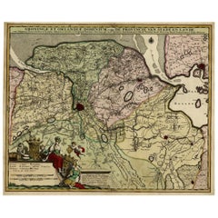
Antique Map of Roermond & Duchy of Guelders by Sanson – Hand-Colored, c.1667
$696.62
£516.48
€580
CA$956.99
A$1,044.71
CHF 550.05
MX$12,514.45
NOK 7,034.99
SEK 6,423.06
DKK 4,419.39
About the Item
Antique map of Roermond and the Duchy of Guelders with rich detail, c.1667
This beautifully hand-colored 17th-century map presents the region of Roermond and the broader Duchy of Guelders (Gelderland), a historically significant area in what is now the southeastern Netherlands. The map, engraved with fine detail and artistic embellishment, provides a striking glimpse into the political and geographic landscape of the time. It includes not only Roermond but a wide swath of surrounding towns, rivers, and territorial boundaries.
The map is titled Menapil Evesché de Ruremonde Quartier de Gueldres du Duché de Gueldres and showcases the ecclesiastical and administrative divisions with great clarity. The winding river Maas (Meuse), which forms a natural boundary in several places, is prominently featured in dark blue, drawing the viewer's eye through the composition. Cities and towns are marked with red symbols, and shaded relief indicates mountain ranges and forests. This stylistic approach helps to visualize the region's terrain and its natural barriers, which played a key role in historical conflicts and trade routes.
The artistic cartouche in the lower left corner is elegantly decorated in red and green flourishes, framing the map’s title in classic 17th-century French. The attention to topographical accuracy, political subdivisions, and decorative elements make this print not only historically significant but also a work of art in its own right.
This map would appeal to collectors of Low Countries cartography, historians interested in the Duchy of Guelders, and interior decorators seeking a sophisticated and authentic antique centerpiece. Its geographic focus on a part of Europe where borders were frequently contested gives it added value for those intrigued by historical shifts in power, religion, and trade.
Condition:
Good condition overall. The hand-coloring remains vibrant, with only minor age-toning. Plate mark is strong. This map has been framed before, hence the difference in the border color outside the image. No tears or major foxing visible.
Framing tips:
To enhance its decorative appeal, consider a classic gold or dark wood frame with a wide, off-white acid-free mat to offset the strong colors. UV-protective glass is recommended to preserve the hand-coloring. The map’s vertical composition and balanced detailing make it ideal for display in studies, libraries, or entrance halls. A float-mount frame could also be an elegant option, showcasing the plate mark and original paper edges.
- Dimensions:Height: 17.17 in (43.6 cm)Width: 18.39 in (46.7 cm)Depth: 0.01 in (0.2 mm)
- Materials and Techniques:Paper,Engraved
- Place of Origin:
- Period:Late 17th Century
- Date of Manufacture:1667
- Condition:Good condition overall. The hand-coloring remains vibrant, with only minor age-toning. Plate mark is strong. This map has been framed before, hence the difference in the border color outside the image. No tears or major foxing visible.
- Seller Location:Langweer, NL
- Reference Number:Seller: BG-14068-11stDibs: LU3054345401892
About the Seller
5.0
Recognized Seller
These prestigious sellers are industry leaders and represent the highest echelon for item quality and design.
Platinum Seller
Premium sellers with a 4.7+ rating and 24-hour response times
Established in 2009
1stDibs seller since 2017
2,811 sales on 1stDibs
Typical response time: 1 hour
- ShippingRetrieving quote...Shipping from: Langweer, Netherlands
- Return Policy
More From This Seller
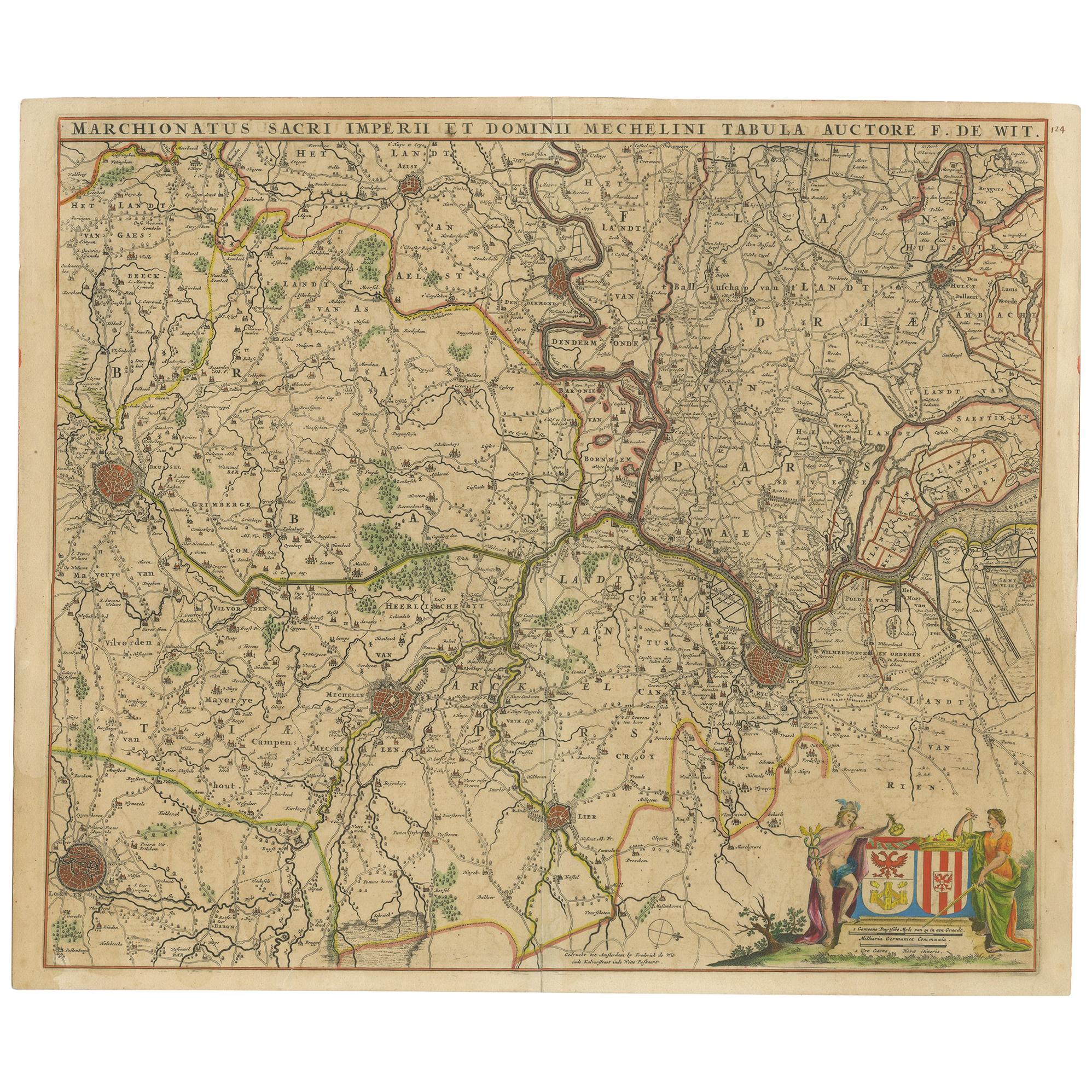
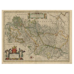
View AllAntique Map of Part of Flanders 'Belgium' by F. de Wit 'circa 1680'
Located in Langweer, NL
Antique map titled 'Marchionatus Sacri Imperii et Dominii Mechelini Tabula'. Large folio size map of the region around Mechelen, Leuven, Brussels, Dendermonde and Antwerp. Published ...
Category
Antique Late 17th Century Maps
Materials
Paper
$552 Sale Price
20% Off
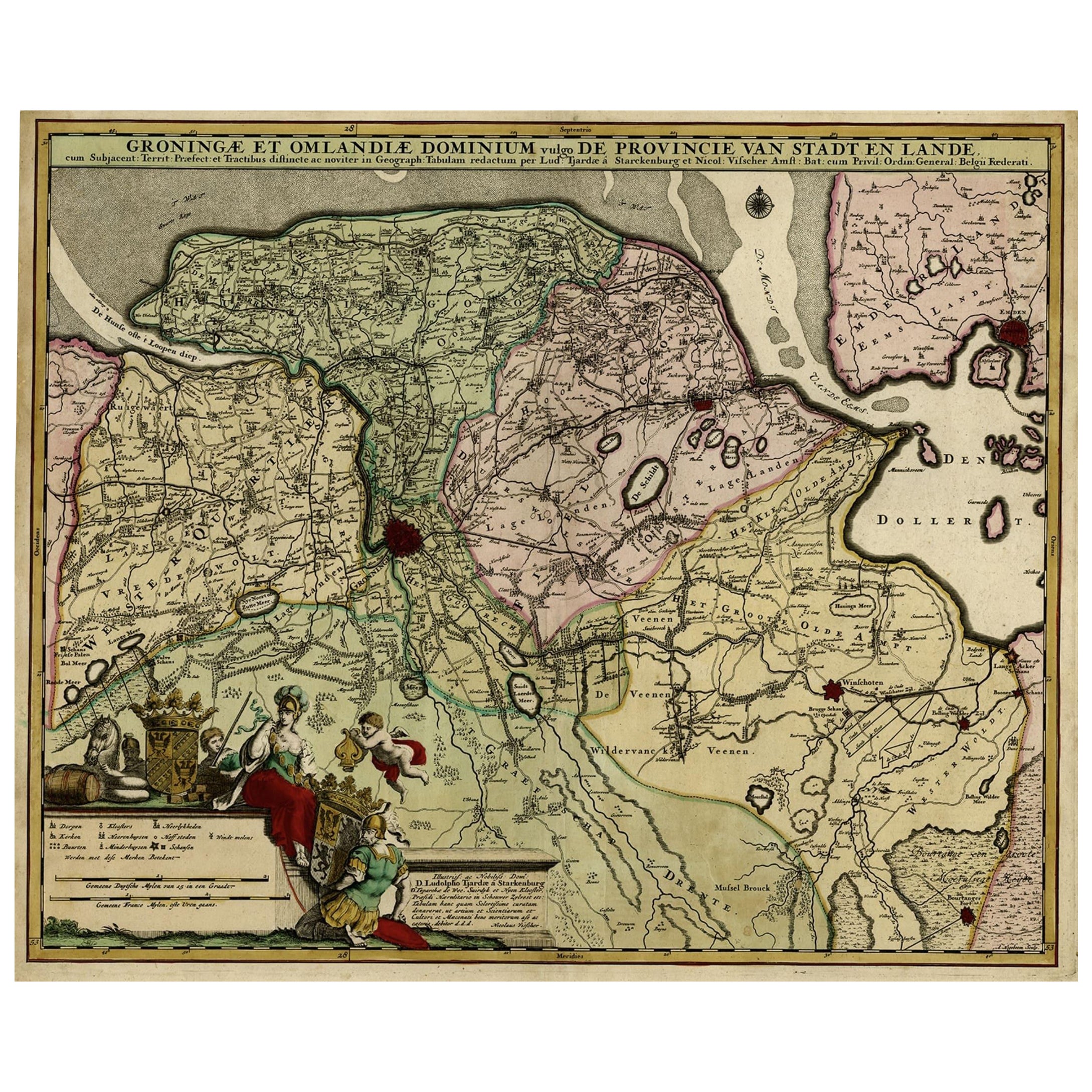
Antique Handcolored Map of the Dutch Province Groningen, Incl. Emden, Ca.1680
Located in Langweer, NL
Antique print, titled: 'Groningae et Omlandiae Dominium vulgo de Pronvicie van Stadt en Lande …'
A map of the Dutch province Groningen. A small part of Germany is also shown (Emd...
Category
Antique 1680s Maps
Materials
Paper
Antique Map of the Hainaut and Namur Region by Janssonius, 'circa 1640'
By Johannes Janssonius
Located in Langweer, NL
Antique map titled 'Comitatuum Hannoniae et Namurci Descriptio'. Old map of the region of Hainaut and Namur, France. Published by J. Janssonius, circa 1640.
Category
Antique Mid-17th Century Maps
Materials
Paper

Antique Map of Belgium and Surroundings, 1692
Located in Langweer, NL
Antique map titled 'Provincie Meridionali de Paesi Bassi Intese sotto nome di Fiandra overo Li Paesi Bassi Cattolici con li confini di Francia di Allemagna et di Hollanda'. Uncommon map of Belgium...
Category
Antique 17th Century Maps
Materials
Paper

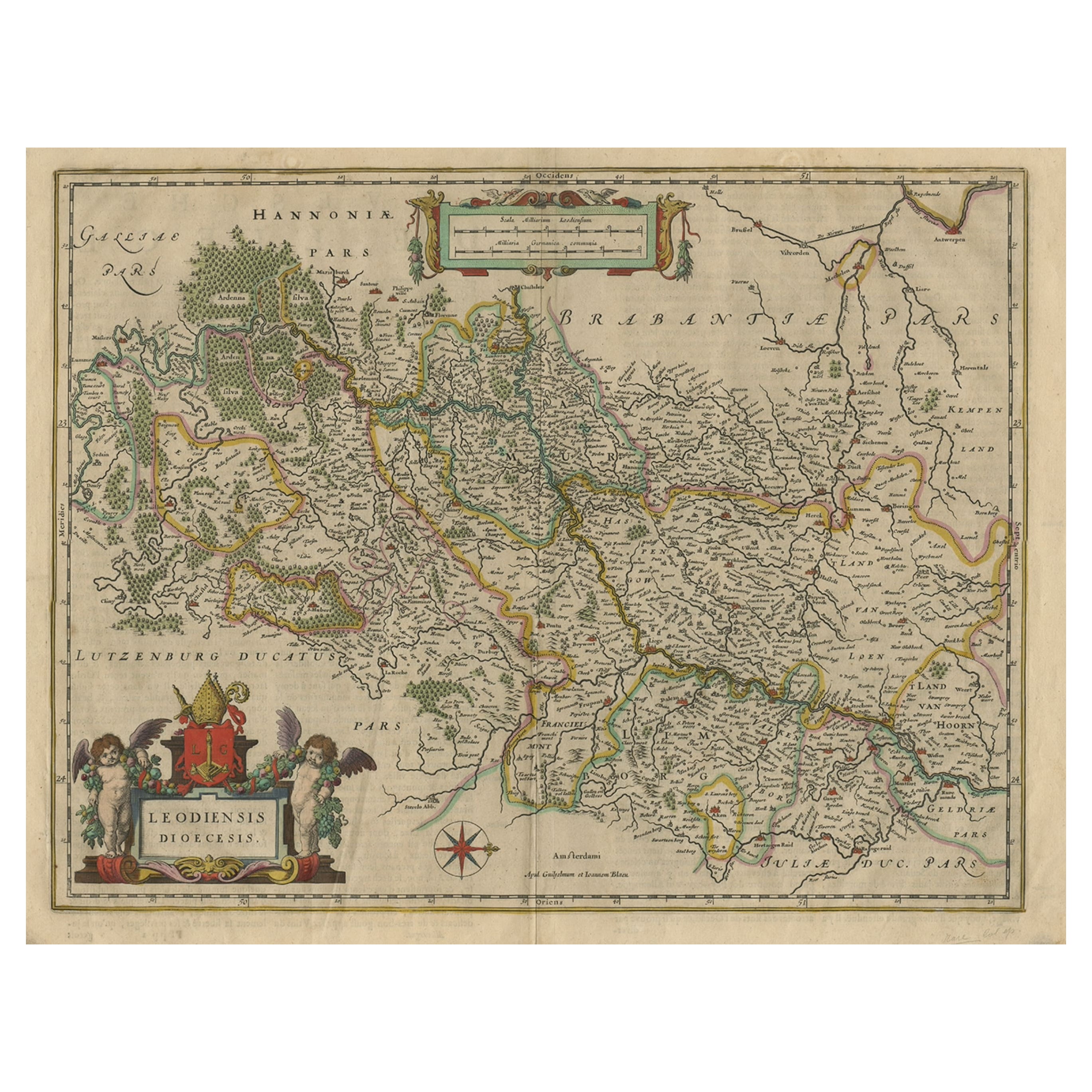
Antique Map of Dutch & Belgium Provinces Limburg, Namen and Ardennes, ca.1635
Located in Langweer, NL
Antique print, titled: 'Leodiensis Dioecesis.'
Detailed map including the Dutch and Belgium provinces Limburg and the Belgium province of Namen and Ardennes. Exquisitely engraved...
Category
Antique 1630s Maps
Materials
Paper
$624 Sale Price
20% Off
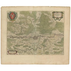
Antique Map of the Frankfurt Region by Johannes Janssonius, Hand-Colored, C.1650
Located in Langweer, NL
Antique Map of the Frankfurt Region by Johannes Janssonius circa 1650 Hand-Colored
This rare and beautifully detailed antique map titled Territorium Francofurtense depicts the reg...
Category
Antique 1650s Maps
Materials
Paper
You May Also Like
17th Century Hand Colored Map of the Liege Region in Belgium by Visscher
By Nicolaes Visscher II
Located in Alamo, CA
An original 17th century map entitled "Leodiensis Episcopatus in omnes Subjacentes Provincias distincté divisusVisscher, Leodiensis Episcopatus" by Nicolaes Visscher II, published in Amsterdam in 1688. The map is centered on Liege, Belgium, includes the area between Antwerp, Turnhout, Roermond, Cologne, Trier and Dinant.
This attractive map is presented in a cream-colored mat measuring 30" wide x 27.5" high. There is a central fold, as issued. There is minimal spotting in the upper margin and a tiny spot in the right lower margin, which are under the mat. The map is otherwise in excellent condition.
The Visscher family were one of the great cartographic families of the 17th century. Begun by Claes Jansz Visscher...
Category
Antique Late 17th Century Dutch Maps
Materials
Paper

$940 Sale Price
20% Off
17th Century Hand-Colored Map of a Region in West Germany by Janssonius
By Johannes Janssonius
Located in Alamo, CA
This attractive highly detailed 17th century original hand-colored map is entitled "Archiepiscopatus Maghdeburgensis et Anhaltinus Ducatus cum terris adjacentibus". It was published ...
Category
Antique Mid-17th Century Dutch Maps
Materials
Paper

$1,020 Sale Price
20% Off
1635 Willem Blaeu Map of Northern France"Comitatvs Bellovacvm" Ric.a08
Located in Norton, MA
1635 Willem Blaeu map of northern France, entitled.
"Comitatvs Bellovacvm Vernacule Beavvais,"
Colored
Ric.a008
“COMITATVS BELLOVACVM…” Amsterdam: W...
Category
Antique 17th Century Unknown Maps
Materials
Paper

1571-1638 Willem Blaeu map entitled, "Ilcadorino, " Hand Colored Ric0009
Located in Norton, MA
Willem Blaeu map entitled,
"Ilcadorino,".
Hand colored.
Description: large, unusual, and nice antique copper engraved map of Ilcadorino, by Willem BL...
Category
Antique 16th Century Dutch Maps
Materials
Paper

1640 Joan Bleau Map Entitled"Diocecese de rheims et le pais de rethel, " Eic.a011
Located in Norton, MA
1640 Joan Bleau map entitled
"Diocecese de rheims et le pais de rethel,"
Ric.a011
OAN BLAEU
Diocecese de Rheims, et le pais de Rethel.
Handcolored engraving, c.1640.
...
Category
Antique 17th Century Dutch Maps
Materials
Paper

1640 Willem Blaeu Map Entitled "Contado di molise et principato vltra, " Ric.a003
By Willem Blaeu
Located in Norton, MA
1640 Willem Blaeu map entitled
"Contado di molise et principato vltra,"
Colored
Ric. a003
Measures: 38 x 49.6 cm and wide margins
DBLAEU.
Cou...
Category
Antique 17th Century Dutch Maps
Materials
Paper

More Ways To Browse
Paisley Rugs and Carpets
Black And Chrome Lounge Chair
Vintage 1930 Dining Room Set
Antique Victorian Dining Tables
Environment Furniture
Italian Plastic Chairs
Made In Belgium
Black Crystal Glasses
French Mid Century Modern Rug
China Silk Rug
Chrome Glass Coffee Tables
Antique Italian Chairs
Antique Walnut Bar
Beni Ourain Rugs
French Iron And Glass Table
Glass Top Wood Base Coffee Tables
T Chair
Antique Silver Basket