Items Similar to Antique Map of Saxon England according to the Anglo-Saxon Chronicle
Want more images or videos?
Request additional images or videos from the seller
1 of 6
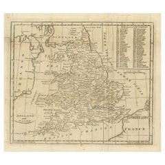
Antique Map of Saxon England according to the Anglo-Saxon Chronicle
About the Item
Antique map titled 'Saxon England According to the Saxon Chronicle'. Map of Saxon England based upon descriptions in the Anglo-Saxon Chronicle, a collection of annals in Old English chronicling the history of the Anglo-Saxons.
This map originates from 'Britannia: or, a Chorographical Description of the Flourishing Kingdoms of England, Scotland, and Ireland, and the Islands Adjacent', a series of 4 travel logs written by William Camden (1551-1623) in 1586. Published 1806.
- Dimensions:Height: 16.03 in (40.7 cm)Width: 10.24 in (26 cm)Depth: 0.02 in (0.5 mm)
- Materials and Techniques:
- Period:
- Date of Manufacture:1806
- Condition:General age-related toning. Minor wear and soiling, blank verso. Small defects in margins. Please study image carefully.
- Seller Location:Langweer, NL
- Reference Number:
About the Seller
5.0
Platinum Seller
These expertly vetted sellers are 1stDibs' most experienced sellers and are rated highest by our customers.
Established in 2009
1stDibs seller since 2017
1,919 sales on 1stDibs
Typical response time: <1 hour
- ShippingRetrieving quote...Ships From: Langweer, Netherlands
- Return PolicyA return for this item may be initiated within 14 days of delivery.
More From This SellerView All
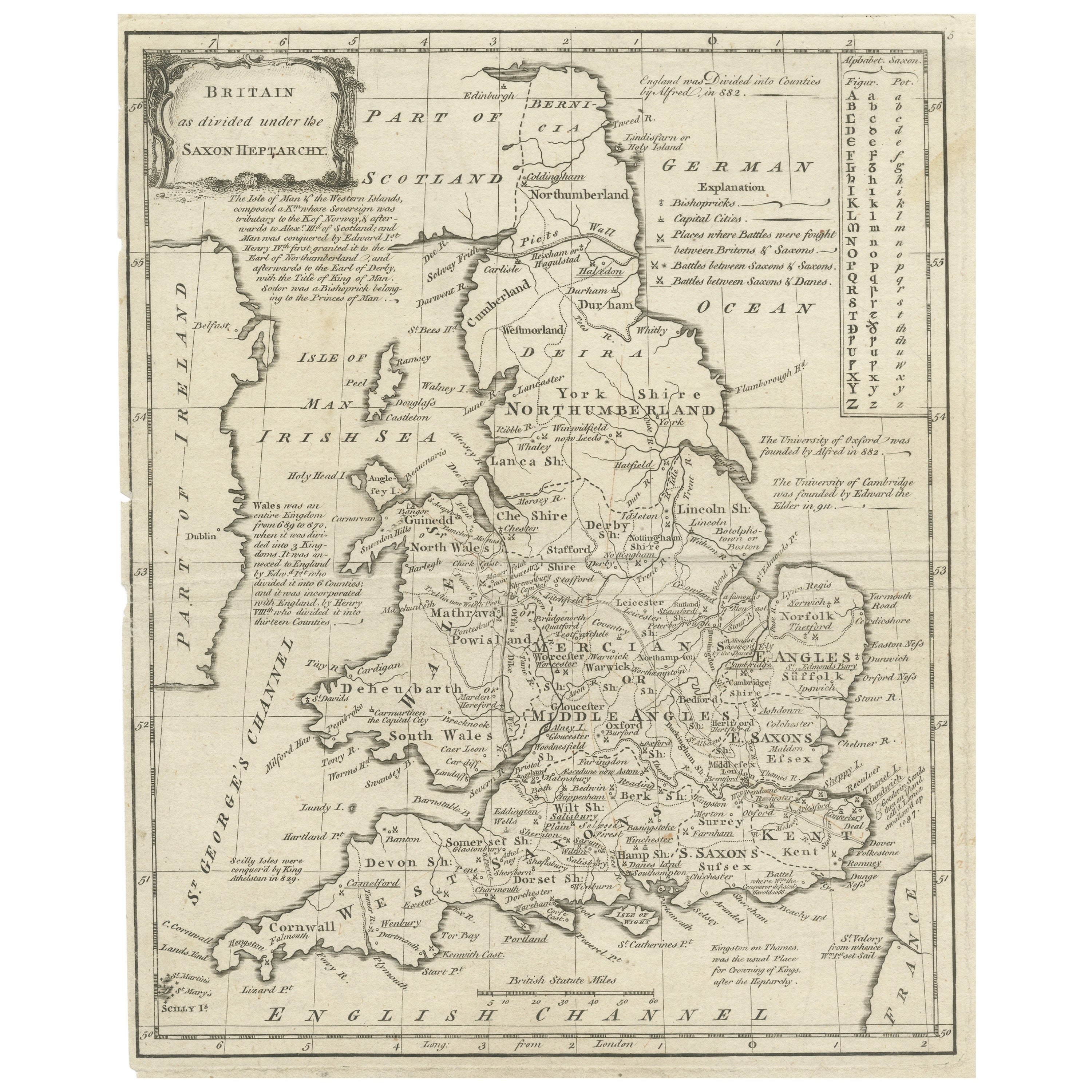
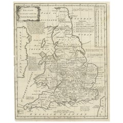
- Antique Map of England and Wales Depicting the Period of the Saxon HeptarchyLocated in Langweer, NLAntique map titled 'Britain as divided under the Saxon Heptarchy'. An antique copper engraving map of England and Wales by Joseph Ellis depicting the period of the Saxon Heptarchy. E...Category
Antique Late 18th Century Maps
MaterialsPaper
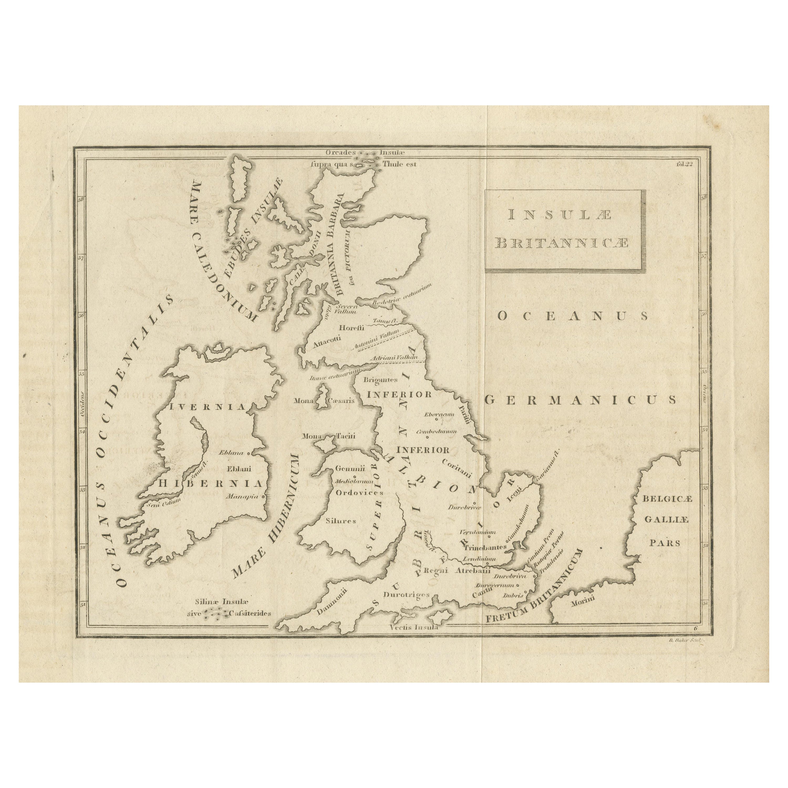
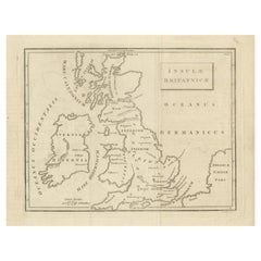
- Antique Map of the British Isles According to the Geography of the Roman EmpireLocated in Langweer, NLAntique map titled 'Insulae Britannicae'. Interesting map of Britain, Scotland, and Ireland. It shows a rudimentary outline of the islands according to the geography of the Roman Emp...Category
Antique Late 18th Century Maps
MaterialsPaper
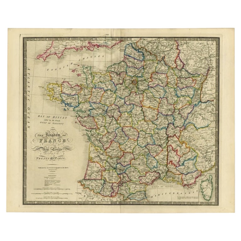
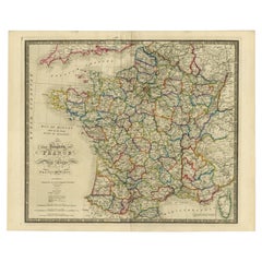
- Antique Map of France according to the Treaty of Paris '1815', Published in 1854Located in Langweer, NLAntique map titled 'The Kingdom of France, describing the new limits according to the treaty of Paris. (1815)'. Large map of France. From James Wyld's 'A New General Atlas of Modern ...Category
Antique 19th Century Maps
MaterialsPaper
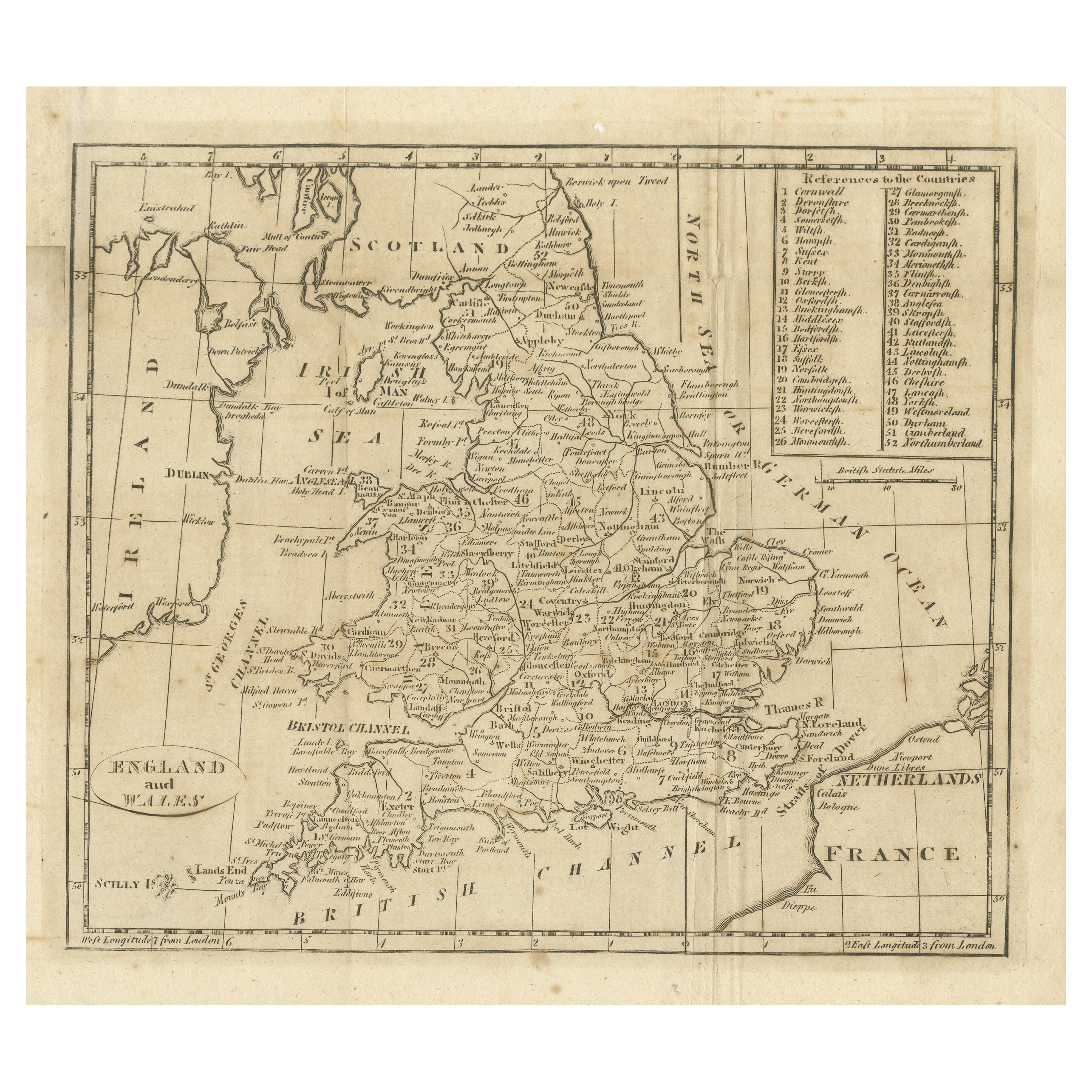
- Antique Map of England and Wales, with References to the CountiesLocated in Langweer, NLAntique map titled 'England and Wales'. Original antique map of England and Wales, with references to the counties. Source unknown, to be determined. Published circa 1820.Category
Antique Early 19th Century Maps
MaterialsPaper
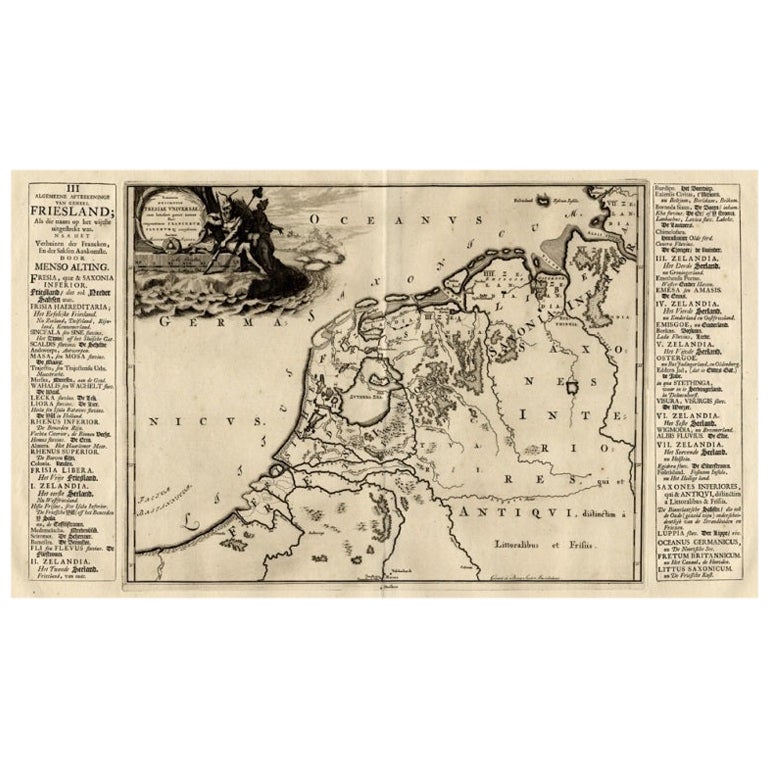
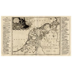
- Antique Map of The Netherlands in The The Saxons and The Franks Period, 1718Located in Langweer, NLAntique map Friesland titled 'Summaria descriptio Fresiae Universae (..)'. Old map of Friesland, the Netherlands. Depicts the general delineation of Friesland during its widest sprea...Category
Antique 18th Century Maps
MaterialsPaper
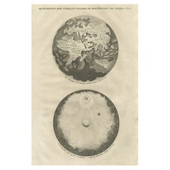
- Original Antique Engraving of the Creation of the World According to Mozes, 1725Located in Langweer, NLAntique map titled 'De Schepping der Wereldt volgens de Beschryving van Mozes' - This plate shows the creation of the world according to Moses. The upper depiction shows the world wi...Category
Antique 18th Century Maps
MaterialsPaper
You May Also Like
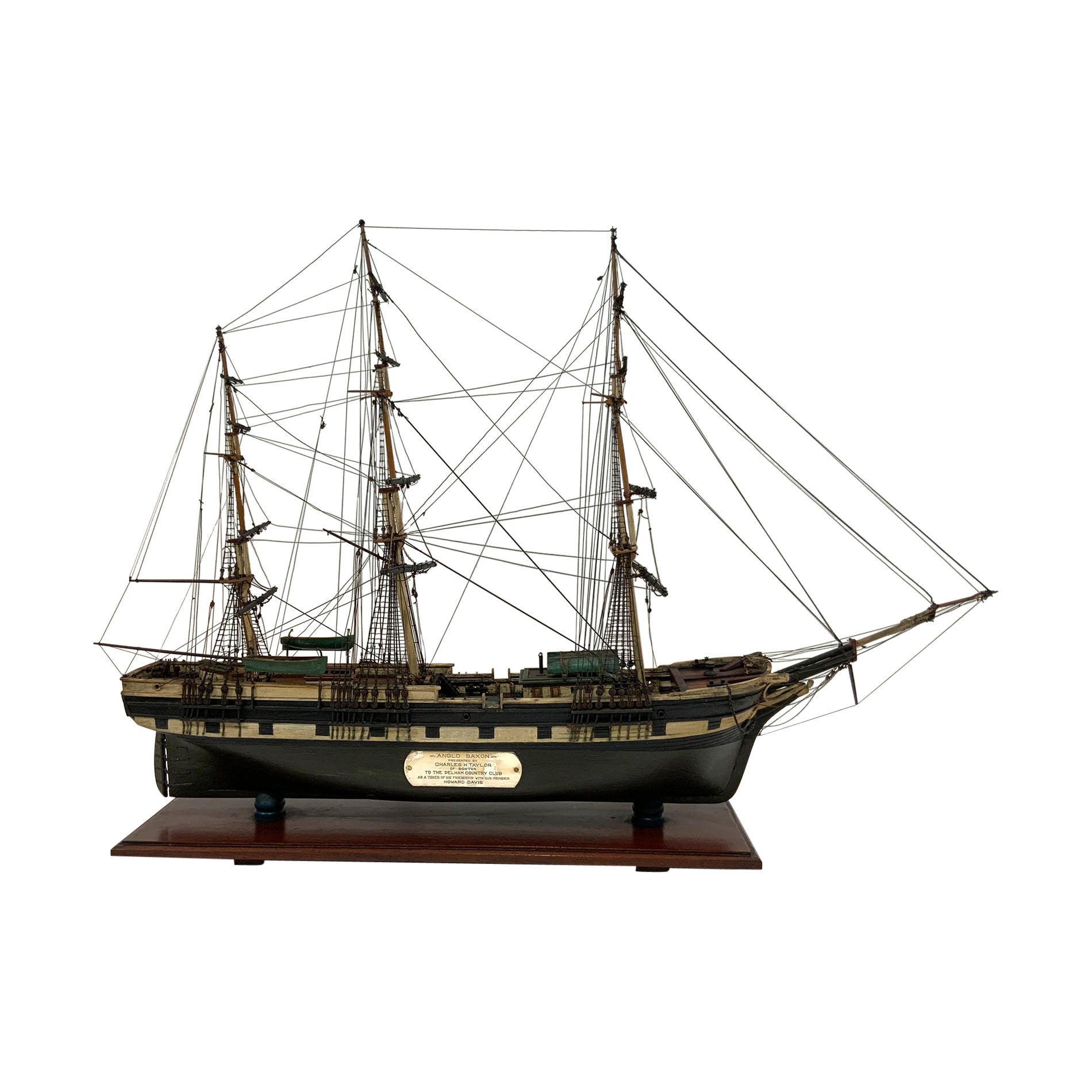
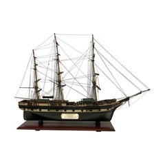
- Period Model of the Packet Anglo SaxonLocated in Norwell, MAAntique ship model with provenance. This model of the packet ship “Anglo Saxon” was “presented by Charles H Taylor of Boston to the Pelham Country Club as ...Category
Vintage 1930s North American Models and Miniatures
MaterialsWood
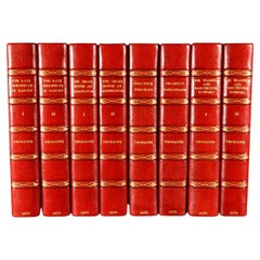
- 1879 The Chronicles of BarsetshireBy Anthony TrollopeLocated in Bath, GBA fine Bayntun-Riviere set of Anthony Trollope's noted series 'The Chronicles of Barsetshire'. With an illustrated frontispiece to all volumes. Anthony Trollope (1815-1882) was an...Category
Antique 1870s English Books
MaterialsPaper
- According to The Rolling Stones Hardcover Table BookLocated in North Hollywood, CAThe Rolling Stones, ACCORDING TO THE ROLLING STONES. California: Chronicle Books, 2003. First Edition; First Printing. Hardcover. Large Hardcover Book. 12 X 9 X 1.6 inches; 360 pages. Printed signatures of all of them, great collectible Rock N Roll hardcover coffee table book. Title: According to the Rolling Stones Publisher: Music Sales Publication Date: 2003 Binding: Hardcover Synopsis: Here's the inside story: the history of the Rolling Stones - according to the Rolling Stones. Mick Jagger, Keith Richards, Charlie Watts, and Ronnie Wood have come together for this remarkable project. They've also opened up their personal and band archives to include many rare and intimate images that are interwoven with the text. The book gets right to the heart of what makes the Stones the Stones, as musicians, songwriters, performers, and colleagues. They describe how their music has evolved and how it has affected and changed their lives. They also reveal, with refreshing frankness, how their own lives have helped, or hindered, their music-making. The Stones' own words - insightful, funny, poignant, surprising, and above all, completely authentic - are complemented by insider reflections from key players in their story over the years such as Ahmet Ertegun, David Bailey, and Cameron Crowe. A comprehensive reference section including discography, and chronology, studded with the Stones' personal comments on the music and memories, completes this must-read volume. Here, in their own words and images, is the life and work of a band which has played the soundtrack of our lives for the last forty years. According to the Rolling Stones hews closely to the formula set in 2000 by the publication of The Beatles Anthology. Like its predecessor, it's a beautiful coffee table tome with hundreds of gorgeous photographs, from childhood pics of Mick Jagger and Keith Richards to concert shots from the 40 Licks Tour. The text is taken from recent interviews with the band's four latter-day members (Mick, Keith, Charlie Watts, and Ronnie Wood). Notably missing, however, is any contribution from former bassist Bill Wyman, who left the band in the early '90s and published his own history of the band in 2002, Rolling with the Stones. Where Wyman is an obsessive collector and diarist, the other Stones are more impressionistic in their memories, lending an approach to history as casual as the band’s concerts are rigorously planned and staged. The first half of the Stones story has plenty of high drama (tours through the segregated South, Brian Jones's death, Altamont), which no one seems eager to reflect on deeply. (Charlie is the only one even to mention Altamont.) The more recent years has seen a long string of ever-more-successful tours and ever-less-popular albums, interrupted only by Mick and Keith’s near divorce in the '80s, plus rehab stints for Charlie and Ronnie. While The Beatles Anthology offered the surviving members' interpretations of their experiences at a distance of 30 or more years, the Stones are still living the tale they're trying to tell--and they aren’t always the most self-aware narrators. Or generous: Wyman's three-decade tenure is given short shrift, but the book finds enough space for some unnecessary digs (Wyman has "tiny hands," we're told, and an "almost effeminate" style of playing). To flesh out the band members' own recollections, the book also contains 13 essays from music-industry friends (Ahmet Ertegun, Marshall Chess), collaborators (Don Was), famous fans (Sheryl Crow...Category
21st Century and Contemporary American Modern Books
MaterialsPaper
- Old Horizontal Map of EnglandBy TassoLocated in Alessandria, PiemonteST/520 - Old rare Italian map of England, dated 1826-1827 - by Girolamo Tasso, editor in Venise, for the atlas of M.r Le-Sage.Category
Antique Early 19th Century Italian Other Prints
MaterialsPaper
- Gold Leaf Foil Pictorial Plan Map of the West Country of England Antique StyleLocated in GBWe are delighted to offer for sale this lovely Antique style pictorial plan map of the West Country of England etched in gold leaf foil This is a very interesting and decorative p...Category
20th Century English Adam Style Maps
MaterialsGold Leaf
- Large Scale Antique Scroll Map of Lincolnshire, England, Dated 1778Located in St Annes, LancashireWonderful scroll map of Lincolnshire By Captain Armstrong, 1778 Copper plate engraving on paper laid on canvas Original ebonized wood frame with lo...Category
Antique 1770s English Georgian Maps
MaterialsWood, Paper


Recently Viewed
View AllMore Ways To Browse
Pakistan Antique Map
Armenia Map
Armenian Map
Antique Maps Uk
Antique Uk Map
Antique Uk Maps
Northumberland Map
Uk Antique Map
Ancient Map Of Jerusalem
Antique Jamaica Map
Antique Map Brooklyn
Antique Map Of Brooklyn
Antique Map Of Jamaica
Corse Antique
Map Of The Bahamas
Old Sicily Map
Saudi Arabia Antique Map
Tunisia Antique Map