Items Similar to Antique Map of Southeast Asia by Larousse, 1897
Want more images or videos?
Request additional images or videos from the seller
1 of 5
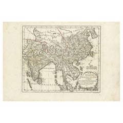
Antique Map of Southeast Asia by Larousse, 1897
About the Item
"Front: 'Carte Generale des Indes.' (General map of India / The Indies / Thailand / Malaysia). Rear: 'Empire des Indes.' (India; artefacts, architecture, design, ornaments).' This lithographic print originates from: 'Nouveau Larousse Illustre en sept volumes.', Directeur Claude Auge, Paris, published 1897-1904, with a supplement addedin 1907. The Nouveau Larousse illustre (New Larousse Illustrated) was an illustrated French language encyclopedia published by Larousse between 1897-1904, in 7 volumes and a supplement. It was essentially a scaled-down version of the 'Grand dictionnaire universel du XIXesiècle.' (Great universal dictionary of the 19th century) of Pierre Larousse, but updated and written in a more neutral, scientific style under the editorship of Claude Auge. Artists and Engravers: Pierre Larousse (1817-1875). Claude Auge (1854-1924). Plate by Vignerot Demoulin after H. Chartier.
Artist: Pierre Larousse (1817-1875). Claude Auge (1854-1924). Plate by Vignerot Demoulin after H. Chartier.
Condition: Excellent. General age related toning and occasional light staining from handling. Irregular left paper edge from binding. Please study image carefully.
Date: 1897
Overall size: 31 x 23 cm.
Image size: 0.001 x 27.5 x 22.5 cm.
Antique prints have long been appreciated for both their aesthetic and investment value. They were the product of engraved, etched or lithographed plates. These plates were handmade out of wood or metal, which required an incredible level of skill, patience and craftsmanship. Whether you have a house with Victorian furniture or more contemporary decor an old engraving can enhance your living space. We offer a wide range of authentic antique prints for any budget."
- Dimensions:Height: 9.06 in (23 cm)Width: 12.21 in (31 cm)Depth: 0 in (0.01 mm)
- Materials and Techniques:
- Period:
- Date of Manufacture:1897
- Condition:
- Seller Location:Langweer, NL
- Reference Number:
About the Seller
5.0
Platinum Seller
These expertly vetted sellers are 1stDibs' most experienced sellers and are rated highest by our customers.
Established in 2009
1stDibs seller since 2017
1,933 sales on 1stDibs
Typical response time: <1 hour
- ShippingRetrieving quote...Ships From: Langweer, Netherlands
- Return PolicyA return for this item may be initiated within 14 days of delivery.
More From This SellerView All
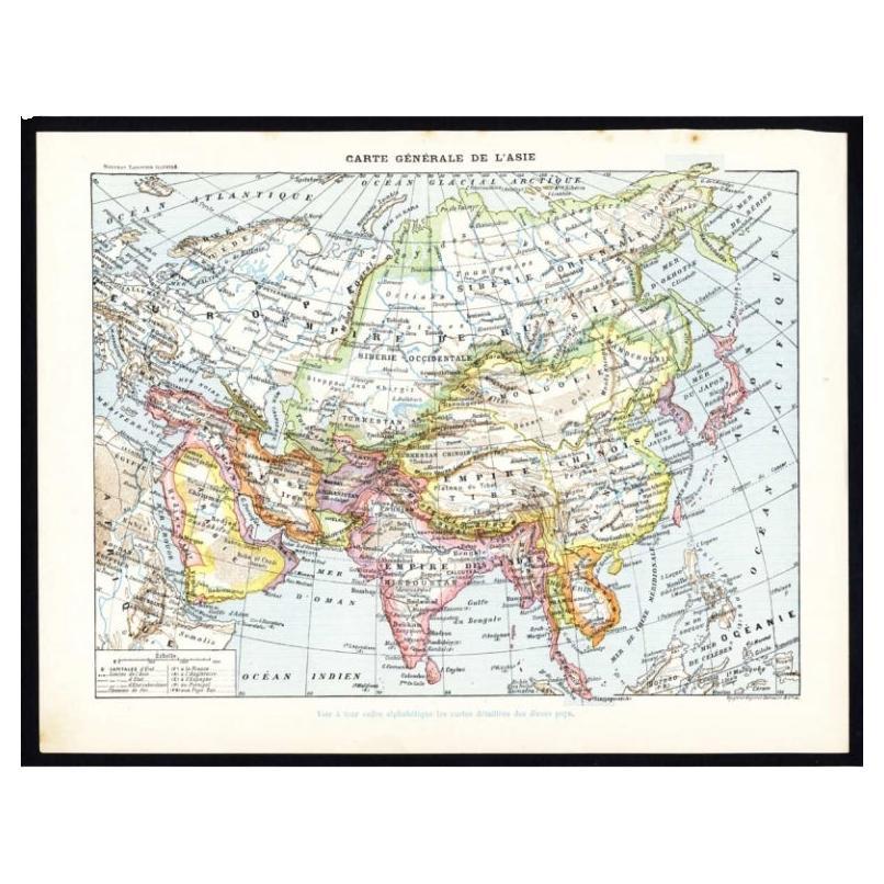
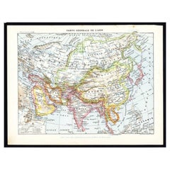
- Antique Map of Asia by Larousse, 1897Located in Langweer, NLFront: 'Carte Generale de l'Asie.' (General map of Asia). Rear: 'Asie.' (Asia, scenes of Asia, nature, plants and animals, people, costume).' This rare early lithographic print origi...Category
Antique 19th Century Maps
MaterialsPaper
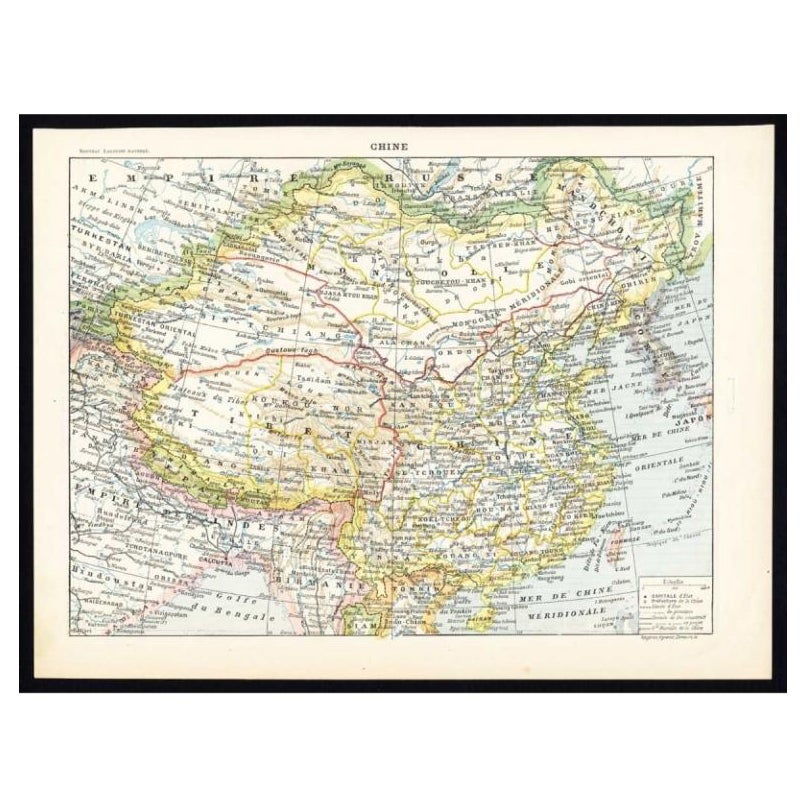
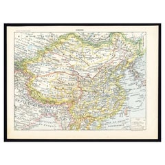
- Antique Map of China by Larousse, 1897By Pierre LarousseLocated in Langweer, NLSheet: Front: 'Chine.' (China map). Verso: 'China.' (China views, nature, animals, costume). This rare early lithographic print originates from: 'Nouveau Lar...Category
Antique 19th Century Maps
MaterialsPaper
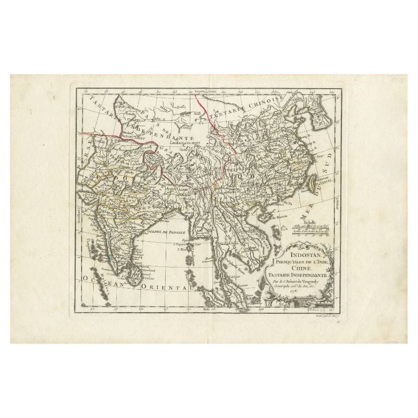
- Antique Map of Southeast Asia by Dussy, 1778Located in Langweer, NL"Antique map titled 'Indostan presqu'isles de l'Inde, Chine, Tartarie Independante.' - A map of Asia: Hindustan, India and China. This map originates from 'Nouvel Atlas Portatif dest...Category
Antique 18th Century Maps
MaterialsPaper
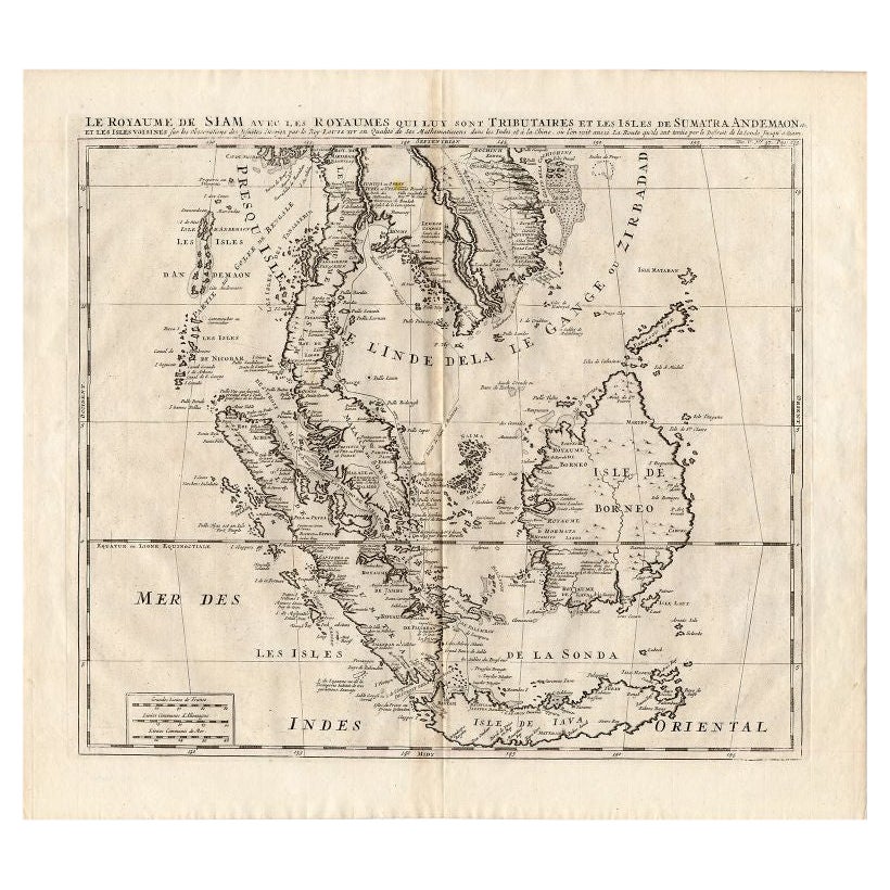
- Antique Map of Southeast Asia by Chatelain, c.1732Located in Langweer, NL"Antique map titled 'La Royaume de Siam avec les Royaumes qui luy sont Tributaires et les Isles de Sumatra Andemaon'. It shows: Southeast Asia; Borneo, Java, Siam (Thailand), Malacca...Category
Antique 18th Century Maps
MaterialsPaper
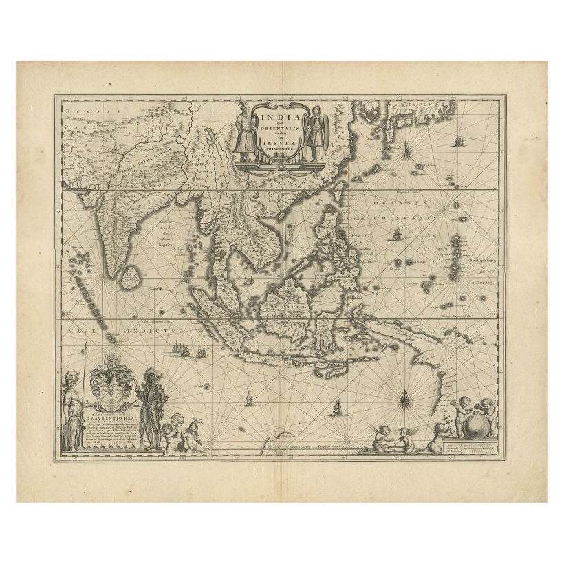
- Antique Map of Southeast Asia by Blaeu, c.1640Located in Langweer, NL"Antique map titled 'India quae Orientalis dicitur et Insulae adiacentes'. Map of Southeast Asia, extending from India to Tibet to Japan to New Guinea. This map is one of the first t...Category
Antique 17th Century Maps
MaterialsPaper
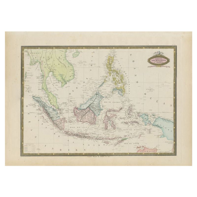
- Antique Map of Southeast Asia by Garnier, 1860Located in Langweer, NL"Antique map titled 'Borneo, Iles de la Sonde, Celebes, Moluques et Phillippines'. Antique map of Southeast Asia, from Birma and Sumatra to the Philippines and Nouveau Guinea. Artist...Category
Antique 19th Century Maps
MaterialsPaper
You May Also Like
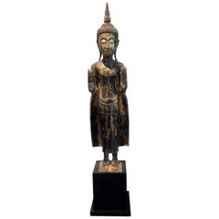
- Antique Giltwood Buddha Statue Southeast AsiaLocated in Atlanta, GAA delicately carved wood Buddha in an upright standing posture with a double Abhaya mudra. The statue displays a gilt surface with beautiful patina and some minor wear. The face was ...Category
Antique 19th Century Thai Other Sculptures and Carvings
MaterialsGold Leaf
- Original Antique Map of Asia. C.1780Located in St Annes, LancashireGreat map of Asia Copper-plate engraving Published C.1780 Two small worm holes to right side of map Unframed.Category
Antique Early 1800s English Georgian Maps
MaterialsPaper

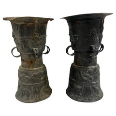
- Pair of Southeast Asian Ceremonial Rain DrumsLocated in Houston, TXPair of Southeast Asian ceremonial rain drums. Estimated that the bronze drums dates to the early 19th century. The top surface is adorned with a ceremonial star and tops are not tha...Category
Antique Early 1800s Indonesian Chinese Export Musical Instruments
MaterialsBronze
- Original Antique Map of South East Asia by Becker, circa 1840Located in St Annes, LancashireGreat map of South East Asia Steel engraving with original color outline Engraved by Becker Published by Virtue, circa 1840. Unframed.Category
Antique 1840s English Other Maps
MaterialsPaper
- Original Antique Map of South East Asia by Thomas Clerk, 1817Located in St Annes, LancashireGreat map of South East Asia Copper-plate engraving Drawn and engraved by Thomas Clerk, Edinburgh. Published by Mackenzie And Dent, 1817 Unframed.Category
Antique 1810s English Maps
MaterialsPaper
- Original Antique Map of South East Asia, Arrowsmith, 1820Located in St Annes, LancashireGreat map of South East Asia Drawn under the direction of Arrowsmith Copper-plate engraving Published by Longman, Hurst, Rees, Orme and Brown, 1820 Unframed.Category
Antique 1820s English Maps
MaterialsPaper


Recently Viewed
View AllMore Ways To Browse
Antique Paper Light
Southeast Asian Wood
Architectural Asian Antiques
Antique Plate With Metal Handle
Empire Antiques Plate
Antique Artefacts
Antique Encyclopedia
Antique Paris Map Print
Antique Southeast Asia
Carte Paris
Southeast Asian Antiques
Wood Artefacts
Thai Artists
Thai Light
Antique Malaysia
Old Asia Map
French Architecture House Design Lithograph
Antique Furniture Malaysia