Items Similar to Antique Map of Sweden & Norway by A.K. Johnston '1865'


Want more images or videos?
Request additional images or videos from the seller
1 of 5
Antique Map of Sweden & Norway by A.K. Johnston '1865'
About the Item
Antique map titled 'Sweden & Norway (Scandinavia)'. With an inset map of Stockholm and environments. This map originates from the ‘Royal Atlas of Modern Geography’ by Alexander Keith Johnston. Published by William Blackwood and Sons, Edinburgh and London, 1865.
- Dimensions:Height: 24.41 in (62 cm)Width: 19.1 in (48.5 cm)Depth: 0.02 in (0.5 mm)
- Materials and Techniques:
- Period:
- Date of Manufacture:1865
- Condition:General age-related toning. Please study image carefully.
- Seller Location:Langweer, NL
- Reference Number:
About the Seller
5.0
Platinum Seller
These expertly vetted sellers are 1stDibs' most experienced sellers and are rated highest by our customers.
Established in 2009
1stDibs seller since 2017
1,928 sales on 1stDibs
Typical response time: <1 hour
- ShippingRetrieving quote...Ships From: Langweer, Netherlands
- Return PolicyA return for this item may be initiated within 14 days of delivery.
More From This SellerView All
- Antique Map of Denmark by A.K. Johnston, 1865Located in Langweer, NLAntique map titled 'Denmark and the Duchies Schleswig, Holstein & Lauenburg; Hanover, Brunswick, Mecklenburg, Oldenburg, Anhalt and Lippe'. With an inset map of Iceland, Copenhagen a...Category
Antique Mid-19th Century Maps
MaterialsPaper
- Antique Map of Scotland 'South' by A.K. Johnston, 1865Located in Langweer, NLAntique map titled 'Scotland (Southern Sheet)'. This map originates from the ‘Royal Atlas of Modern Geography’ by Alexander Keith Johnston. Published by William Blackwood and Sons, E...Category
Antique Mid-19th Century Maps
MaterialsPaper
- Antique Map of South Australia by A.K. Johnston, 1865Located in Langweer, NLAntique map titled 'South Australia, New South Wales, Victoria & Queensland'. This map originates from the ‘Royal Atlas of Modern Geography’ by Alexander Keith Johnston. Published by...Category
Antique Mid-19th Century Maps
MaterialsPaper
- Antique Map of England and Wales by A.K. Johnston, 1865Located in Langweer, NLAntique map titled 'England and Wales (Southern Sheet)'. With an inset map of the Scilly Islands. This map originates from the ‘Royal Atlas of Modern Geography’ by Alexander Keith Jo...Category
Antique Mid-19th Century Maps
MaterialsPaper
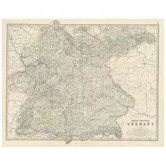
- Antique Map of South-Western Germany by A.K. Johnston, 1865Located in Langweer, NLAntique map titled 'South-Western Germany'. This map originates from the ‘Royal Atlas of Modern Geography’ by Alexander Keith Johnston. Published by William Blackwood and Sons, Edinb...Category
Antique Mid-19th Century Maps
MaterialsPaper
- Antique Map of South America ‘North’ by A.K. Johnston, 1865Located in Langweer, NLAntique map titled 'South America, Northern Sheet'. Depicting Guiana, Ecuador, Brazil, Bolivia the Amazones and more. This map originates from the ‘Royal Atlas of Modern Geography’ b...Category
Antique Mid-19th Century Maps
MaterialsPaper


You May Also Like
- Original Antique Map of Sweden and Norway, Grattan and Gilbert, 1843Located in St Annes, LancashireGreat map of Sweden and Norway Drawn and engraved by Archer Published by Grattan and Gilbert Original color Unframed.Category
Antique 1840s English Other Maps
MaterialsPaper
- Original Antique Map of Sweden, Engraved by Barlow, 1806Located in St Annes, LancashireGreat map of Sweden Copper-plate engraving by Barlow Published by Brightly & Kinnersly, Bungay, Suffolk. 1806 Unframed.Category
Antique Early 1800s English Maps
MaterialsPaper
- Antique Map of Italy by Andriveau-Goujon, 1843By Andriveau-GoujonLocated in New York, NYAntique Map of Italy by Andriveau-Goujon, 1843. Map of Italy in two parts by Andriveau-Goujon for the Library of Prince Carini at Palazzo Carini i...Category
Antique 1840s French Maps
MaterialsLinen, Paper
- Antique Map of Principality of MonacoBy Antonio Vallardi EditoreLocated in Alessandria, PiemonteST/619 - "Old Geographical Atlas of Italy - Topographic map of ex-Principality of Monaco" - ediz Vallardi - Milano - A somewhat special edition ---Category
Antique Late 19th Century Italian Other Prints
MaterialsPaper
- "Lady Washington's Reception, " Engraved by A. H. Ritchie, Antique Print, 1865Located in Colorado Springs, COThis 1865, hand-colored engraving by A. H. Ritchie is entitled Lady Washington's Reception and is based on Daniel F. Huntington's original painting "Th...Category
Antique 1860s American Prints
MaterialsPaper
- Original Antique Map of China by Thomas Clerk, 1817Located in St Annes, LancashireGreat map of China Copper-plate engraving Drawn and engraved by Thomas Clerk, Edinburgh. Published by Mackenzie And Dent, 1817 Unframed.Category
Antique 1810s English Maps
MaterialsPaper


Recently Viewed
View AllMore Ways To Browse
Royal Of Sweden
Swedish Modern Antiques
Maps London
Map London
Antique Norwegian
Norwegian Antique
Antique London Maps
Antique London Map
Antique Map London
London Antique Maps
Antique Maps London
London Antique Map
London Map Antique
Edinburgh Antiques
Antique Norwegian Furniture
Norwegian Antique Furniture
19th Norwegian
19th Century Norwegian