Items Similar to Antique Map of Switzerland by Barlow, 1807

Want more images or videos?
Request additional images or videos from the seller
1 of 5
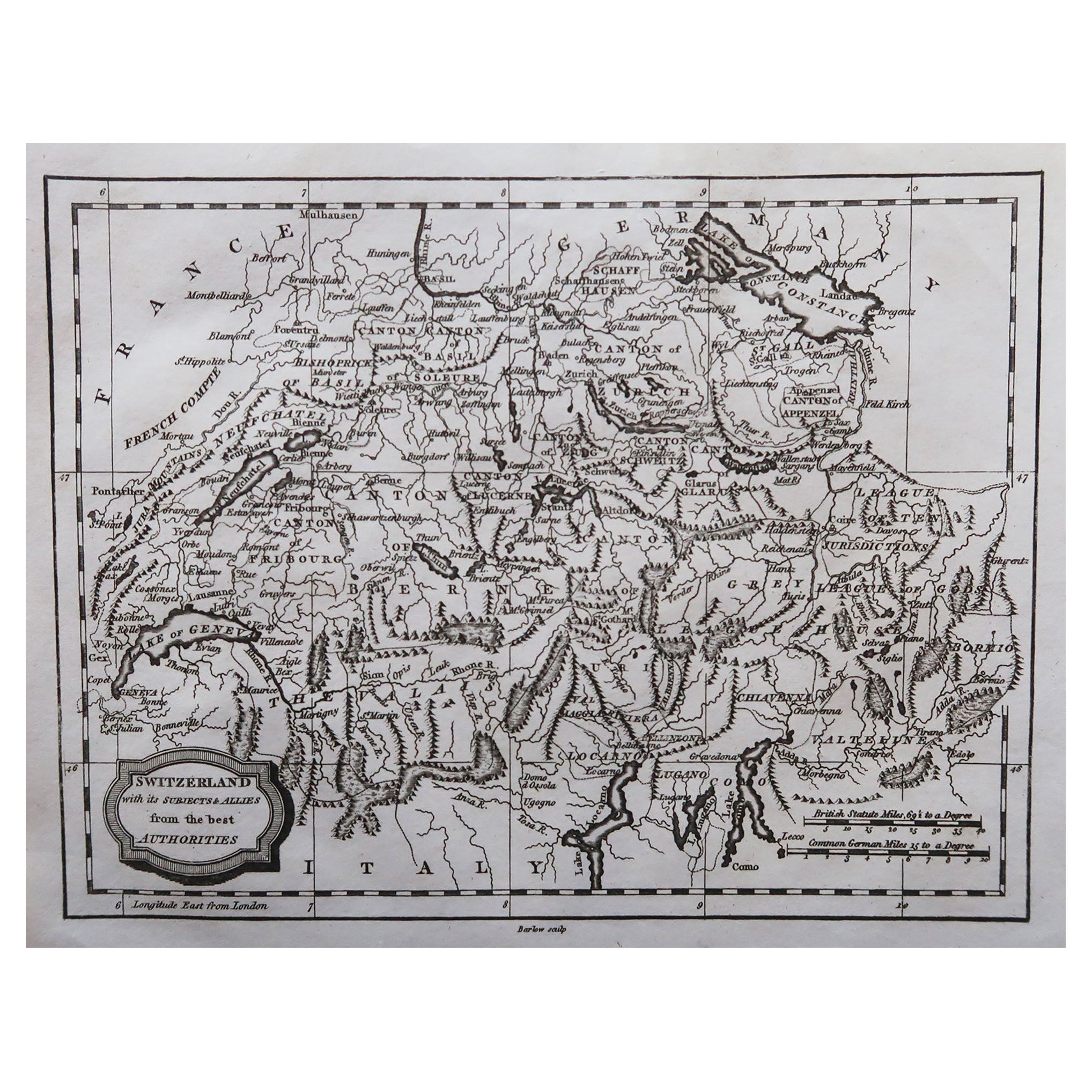
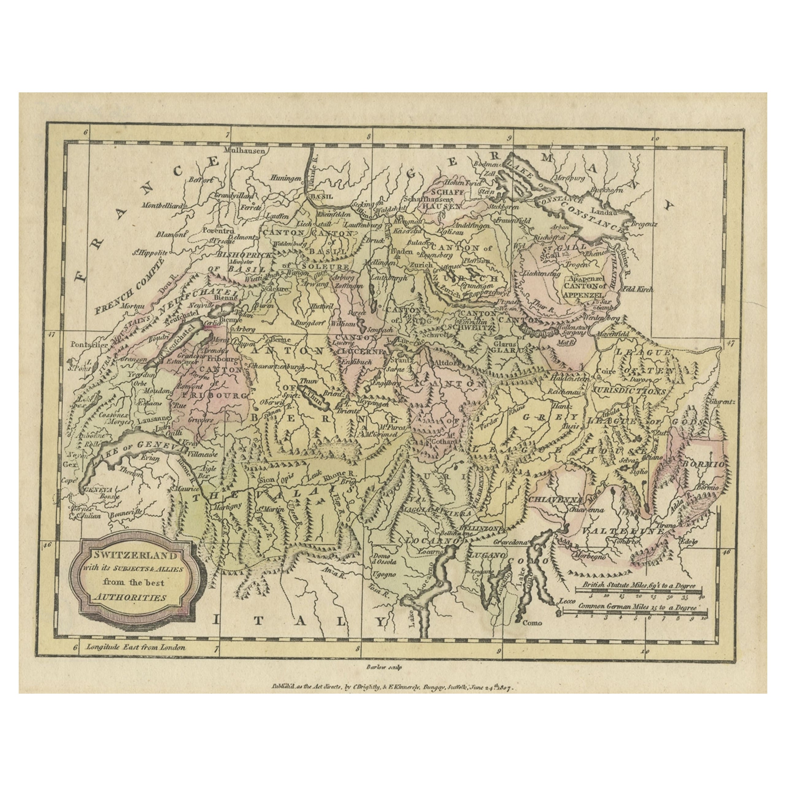
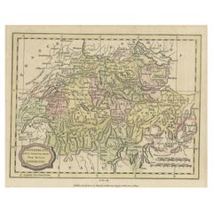
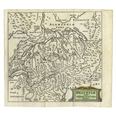
Antique Map of Switzerland by Barlow, 1807
About the Item
Antique map titled 'Switzerland with its subjects & allies from the best authorities'. Small map of Switzerland and surroundings. Originates from 'A general view of the world' by Blomfield. Artists and Engravers: Engraved by J. Barlow. Published by C. Brightly and E. Kinnersly.
Artist: Engraved by J. Barlow. Published by C. Brightly and E. Kinnersly.
Condition: Very good, general age-related toning. Original, contemporary hand coloring. Please study image carefully.
Date: 1807
Overall size: 26 x 20.5 cm.
Image size: 0.001 x 21.5 x 16.5 cm.
Antique prints have long been appreciated for both their aesthetic and investment value. They were the product of engraved, etched or lithographed plates. These plates were handmade out of wood or metal, which required an incredible level of skill, patience and craftsmanship. Whether you have a house with Victorian furniture or more contemporary decor an old engraving can enhance your living space. We offer a wide range of authentic antique prints for any budget.
- Dimensions:Height: 8.08 in (20.5 cm)Width: 10.24 in (26 cm)Depth: 0 in (0.01 mm)
- Materials and Techniques:
- Period:
- Date of Manufacture:1807
- Condition:
- Seller Location:Langweer, NL
- Reference Number:
About the Seller
5.0
Platinum Seller
These expertly vetted sellers are 1stDibs' most experienced sellers and are rated highest by our customers.
Established in 2009
1stDibs seller since 2017
1,933 sales on 1stDibs
Typical response time: <1 hour
- ShippingRetrieving quote...Ships From: Langweer, Netherlands
- Return PolicyA return for this item may be initiated within 14 days of delivery.
More From This SellerView All
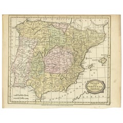
- Small Original Antique Map of Switzerland and Surroundings, 1807Located in Langweer, NLAntique map titled 'Switzerland with its subjects & allies from the best authorities'. Small map of Switzerland and surroundings. Originates from 'A general view of the world' by...Category
Antique Early 1800s Maps
MaterialsPaper
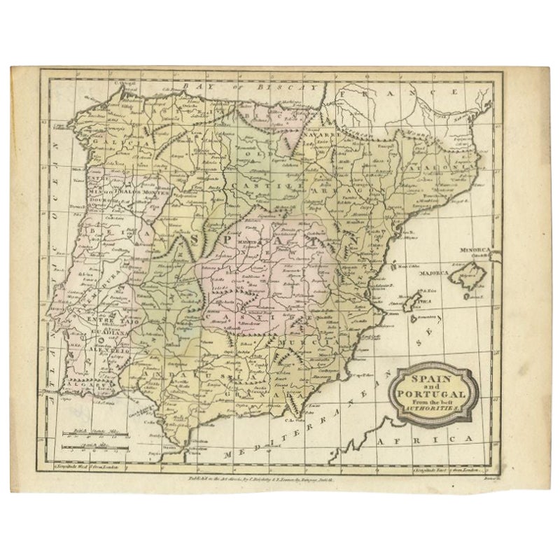
- Antique Map of Spain and Portugal by Barlow, 1809Located in Langweer, NL"Antique map titled 'Spain and Portugal from the best Authorities'. Detailed antique map of Spain and Portugal. This map originates from 'The Gen...Category
Antique 19th Century Maps
MaterialsPaper
- Antique Map of Indonesia by C.F. Beautemps-Beaupre, circa 1807Located in Langweer, NLAntique map titled 'Carte de la partie du grand archipel d'Asie'. Map of Indonesia showing tracks of Recherche and Esperance in 1792-1793. This map is...Category
Antique Early 19th Century Maps
MaterialsPaper
- Antique Map of Switzerland by Lapie, 1842Located in Langweer, NLAntique map titled 'Carte de la Suisse ou Helvetie'. Map of Switzerland. This map originates from 'Atlas universel de géographie ancienne et moderne...Category
Antique Mid-19th Century Maps
MaterialsPaper
- Antique Map of Switzerland by Homann, 1753Located in Langweer, NLAntique map Switzerland titled 'Territorium Reipublicae liberae Helveticae Scaphusiensis (..)'. Regional map of Switzerland. Artists and Engrav...Category
Antique 18th Century Maps
MaterialsPaper
- Antique Map of Switzerland by Cluver, 1685Located in Langweer, NLAntique map titled 'Helvetiae Conterminarumque Terrarii, antiqua descriptio.' Miniature map of Switzerland, from the pocket atlas 'Introductionis in...Category
Antique 17th Century Maps
MaterialsPaper


You May Also Like
- Original Antique Map of Switzerland, Engraved By Barlow, Dated 1807Located in St Annes, LancashireGreat map of Switzerland Copper-plate engraving by Barlow Published by Brightly & Kinnersly, Bungay, Suffolk. Dated 1807 Unframed.Category
Antique Early 1800s English Maps
MaterialsPaper
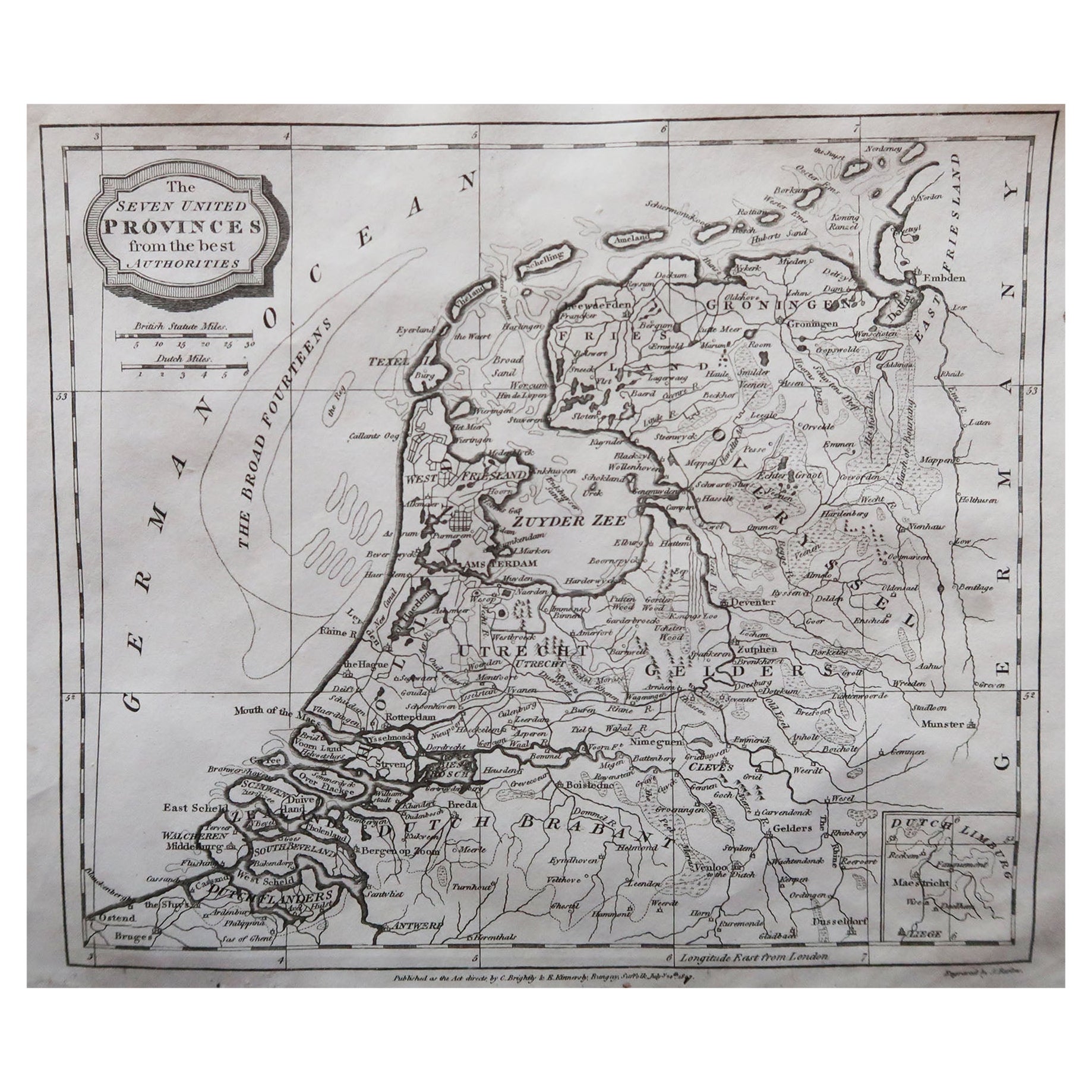
- Original Antique Map of The Netherlands, Engraved by Barlow, Dated 1807Located in St Annes, LancashireGreat map of Netherlands Copper-plate engraving by Barlow Published by Brightly & Kinnersly, Bungay, Suffolk. Dated 1807 Unframed.Category
Antique Early 1800s English Maps
MaterialsPaper
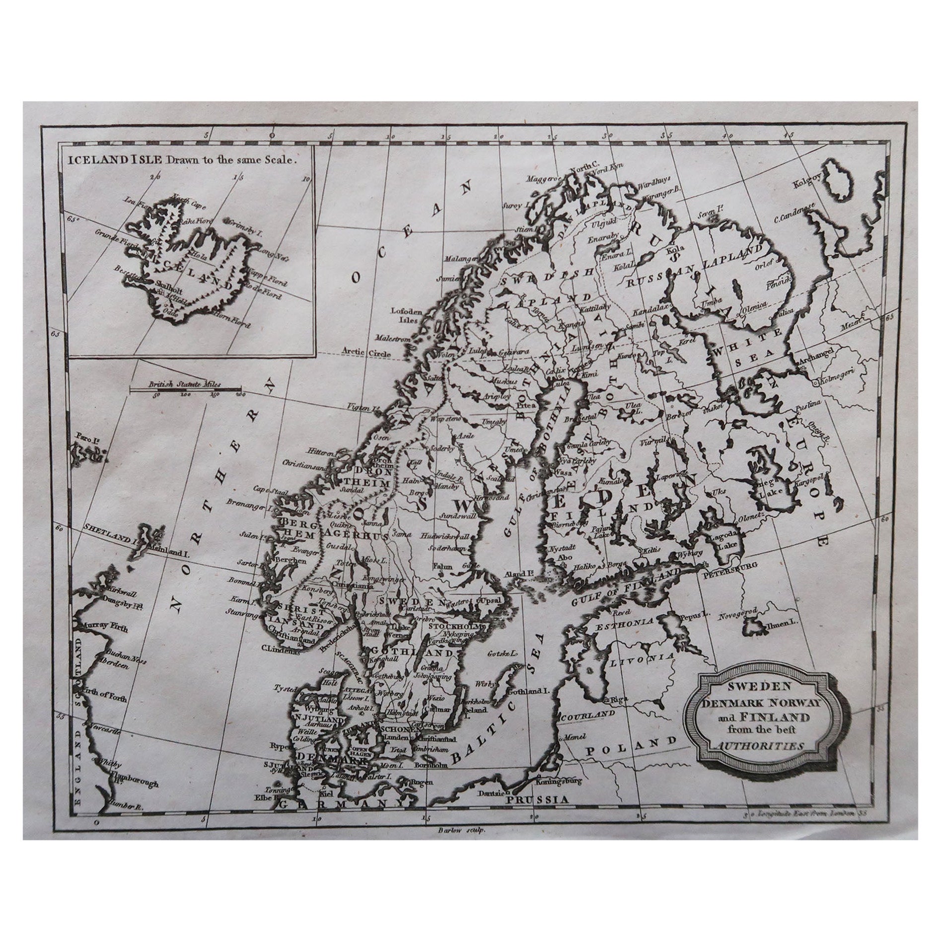
- Original Antique Map of Sweden, Engraved by Barlow, 1806Located in St Annes, LancashireGreat map of Sweden Copper-plate engraving by Barlow Published by Brightly & Kinnersly, Bungay, Suffolk. 1806 Unframed.Category
Antique Early 1800s English Maps
MaterialsPaper
- Original Antique Map of Spain and Portugal, Engraved By Barlow, 1806Located in St Annes, LancashireGreat map of Spain And Portugal Copper-plate engraving by Barlow Published by Brightly & Kinnersly, Bungay, Suffolk. 1806 Unframed.Category
Antique Early 1800s English Maps
MaterialsPaper
- 1861 Topographical Map of the District of Columbia, by Boschke, Antique MapLocated in Colorado Springs, COPresented is an original map of Albert Boschke's extremely sought-after "Topographical Map of the District of Columbia Surveyed in the Years 1856 ...Category
Antique 1860s American Historical Memorabilia
MaterialsPaper
- 1907 Map of Colorado, Antique Topographical Map, by Louis NellLocated in Colorado Springs, COThis highly detailed pocket map is a topographical map of the state of Colorado by Louis Nell from 1907. The map "has been complied from all availabl...Category
Antique Early 1900s American Maps
MaterialsPaper


Recently Viewed
View AllMore Ways To Browse
Swiss Antiques
Swiss Old Furniture
Swiss Metal Antique
Antique Swiss Wood
Swiss Antiques And Collectables
Antique Map Switzerland
Antique Map Of Switzerland
Antique 16th Century Plates
Antique Caribbean Furniture
17th Century Plate Set
Antique Rose Compass
Antique Map Paint
Israeli Antique
Antique Maps Of North America
Tree Bag
North America Antique Map
Survey Map
Ohio Antique