Items Similar to Antique Map of Utrecht in The Netherlands, 1883


Want more images or videos?
Request additional images or videos from the seller
1 of 6
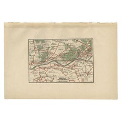
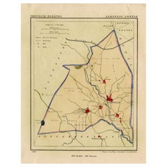
Antique Map of Utrecht in The Netherlands, 1883
$210.98
$263.7320% Off
£156.73
£195.9120% Off
€176
€22020% Off
CA$292.97
CA$366.2120% Off
A$319.70
A$399.6220% Off
CHF 167.69
CHF 209.6120% Off
MX$3,882.84
MX$4,853.5520% Off
NOK 2,094.50
NOK 2,618.1320% Off
SEK 1,979.41
SEK 2,474.2620% Off
DKK 1,339.87
DKK 1,674.8420% Off
About the Item
Antique map titled 'Utrecht'. Map of Utrecht, a province of the Netherlands. This map originates from 'Atlas van Nederland volgens de nieuwe spelregels' by J. Kuyper.
Artists and Engravers: Published by H.D. Tjeenk Willink.
Condition: Good, general age-related toning. Minor wear. Blank verso, please study image carefully.
Date: 1883
Overall size: 28.5 x 19 cm.
Image size: 22 x 16.5 cm.
We sell original antique maps to collectors, historians, educators and interior decorators all over the world. Our collection includes a wide range of authentic antique maps from the 16th to the 20th centuries. Buying and collecting antique maps is a tradition that goes back hundreds of years. Antique maps have proved a richly rewarding investment over the past decade, thanks to a growing appreciation of their unique historical appeal. Today the decorative qualities of antique maps are widely recognized by interior designers who appreciate their beauty and design flexibility. Depending on the individual map, presentation, and context, a rare or antique map can be modern, traditional, abstract, figurative, serious or whimsical. We offer a wide range of authentic antique maps for any budget.
- Dimensions:Height: 7.49 in (19 cm)Width: 11.23 in (28.5 cm)Depth: 0 in (0.01 mm)
- Materials and Techniques:
- Period:
- Date of Manufacture:1883
- Condition:Condition: Good, general age-related toning. Minor wear. Blank verso, please study image carefully.
- Seller Location:Langweer, NL
- Reference Number:Seller: BG-07603-71stDibs: LU3054329312382
About the Seller
5.0
Recognized Seller
These prestigious sellers are industry leaders and represent the highest echelon for item quality and design.
Platinum Seller
Premium sellers with a 4.7+ rating and 24-hour response times
Established in 2009
1stDibs seller since 2017
2,641 sales on 1stDibs
Typical response time: <1 hour
- ShippingRetrieving quote...Shipping from: Langweer, Netherlands
- Return Policy
Authenticity Guarantee
In the unlikely event there’s an issue with an item’s authenticity, contact us within 1 year for a full refund. DetailsMoney-Back Guarantee
If your item is not as described, is damaged in transit, or does not arrive, contact us within 7 days for a full refund. Details24-Hour Cancellation
You have a 24-hour grace period in which to reconsider your purchase, with no questions asked.Vetted Professional Sellers
Our world-class sellers must adhere to strict standards for service and quality, maintaining the integrity of our listings.Price-Match Guarantee
If you find that a seller listed the same item for a lower price elsewhere, we’ll match it.Trusted Global Delivery
Our best-in-class carrier network provides specialized shipping options worldwide, including custom delivery.More From This Seller
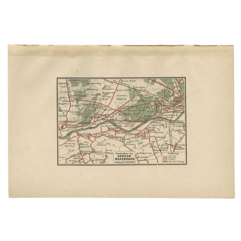
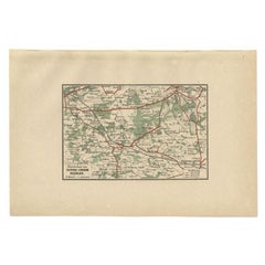
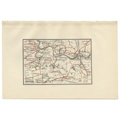
View AllAntique Map of the Region of Arnhem and Wageningen by Craandijk, 1884
Located in Langweer, NL
Antique map titled 'Omstreken van Arnhem, Wageningen'. Old map of the region of Wageningen also including cities and villages like Bennekom, Renkum and Oosterbeek. This map orginates...
Category
Antique 19th Century Maps
Materials
Paper
$83 Sale Price
20% Off
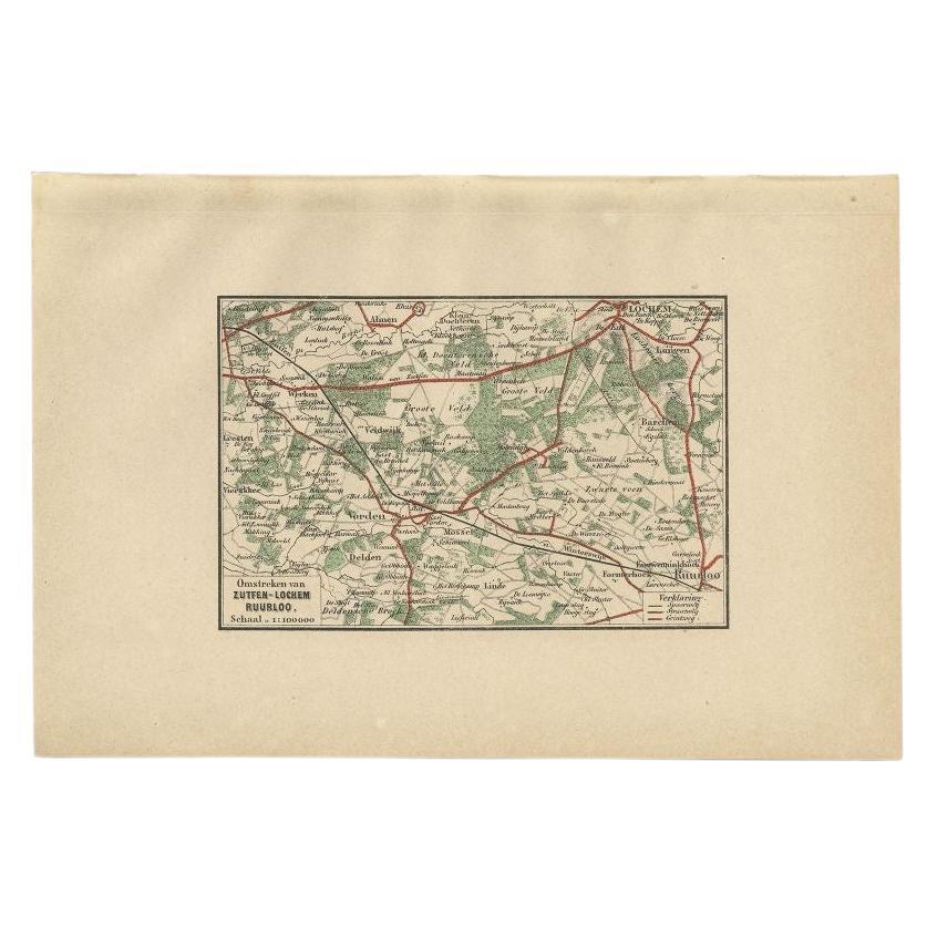
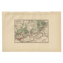
Antique Map of the Region of Zutphen by Craandijk, 1884
Located in Langweer, NL
Antique map titled 'Omstreken van Zutfen - Lochem Ruurlo'. Old map of the region of Zutphen also including cities and villages like Veldwijk, Vorden and Delden. This map orginates fr...
Category
Antique 19th Century Maps
Materials
Paper
$83 Sale Price
20% Off
Antique Map of the Region of Arnhem by Craandijk, 1884
Located in Langweer, NL
Antique map titled 'Omstreken van Arnhem - Dieren'. Old map of the region of Arnhem also including cities and villages like Rozendaal, Velp and Dieren. This map orginates from 'Atlas...
Category
Antique 19th Century Maps
Materials
Paper
$83 Sale Price
20% Off
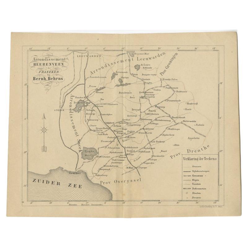
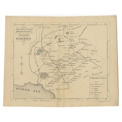
Antique Map of The Region of Heerenveen by Behrns, 1861
Located in Langweer, NL
Antique map titled 'Arrondissement Heerenveen'. Old map depicting the region of Heerenveen including cities and villages like Akkrum, Oudehaske, Wolvega, Donkerbroek and more. This m...
Category
Antique 19th Century Maps
Materials
Paper
$124 Sale Price
20% Off
Antique Map of the Township of Zweelo in the Netherlands, 1865
Located in Langweer, NL
Drenthe: Gemeente Zweelo, Weesup, Meppen, Benneveld. These scarse detailed maps of Dutch Towns originate from the 'Gemeente-atlas' of Jacob Kuyper. This atlas of all towns in the Net...
Category
Antique 19th Century Maps
Materials
Paper
$182 Sale Price
20% Off
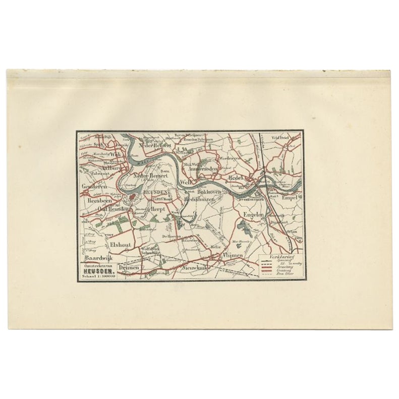
Antique Map of the Region of Heusden by Craandijk, 1884
Located in Langweer, NL
Antique map titled 'Omstreken van Heusden'. Old map of the region of Heusden also including cities and villages like Elshout, Aalburg, Hedel and Vlijmen. This map orginates from 'Atl...
Category
Antique 19th Century Maps
Materials
Paper
$83 Sale Price
20% Off
You May Also Like
Original Antique English County Map, Huntingdonshire, J & C Walker, 1851
Located in St Annes, Lancashire
Great map of Huntingdonshire
Original colour
By J & C Walker
Published by Longman, Rees, Orme, Brown & Co. 1851
Unframed.
Category
Antique 1850s English Other Maps
Materials
Paper

Original Antique English County Map, Cambridgeshire, J & C Walker, 1851
Located in St Annes, Lancashire
Great map of Cambridgeshire
Original colour
By J & C Walker
Published by Longman, Rees, Orme, Brown & Co. 1851
Unframed.
Category
Antique 1850s English Other Maps
Materials
Paper

Original Antique English County Map, Nottinghamshire, J & C Walker, 1851
Located in St Annes, Lancashire
Great map of Nottinghamshire
Original colour
By J & C Walker
Published by Longman, Rees, Orme, Brown & Co. 1851
Unframed.
Category
Antique 1850s English Other Maps
Materials
Paper

Original Antique English County Map, Buckinghamshire, J & C Walker, 1851
Located in St Annes, Lancashire
Great map of Buckinghamshire
Original colour
By J & C Walker
Published by Longman, Rees, Orme, Brown & Co. 1851
Unframed.
Category
Antique 1850s English Other Maps
Materials
Paper

Original Antique English County Map, Warwickshire, J & C Walker, 1851
Located in St Annes, Lancashire
Great map of Warwickshire
Original colour
By J & C Walker
Published by Longman, Rees, Orme, Brown & Co. 1851
Unframed.
Category
Antique 1850s English Other Maps
Materials
Paper

Original Antique English County Map, Leicestershire, J & C Walker, 1851
Located in St Annes, Lancashire
Great map of Leicestershire
Original colour
By J & C Walker
Published by Longman, Rees, Orme, Brown & Co. 1851
Unframed.
Category
Antique 1850s English Other Maps
Materials
Paper

More Ways To Browse
Gibraltar Antique Map
Guyana Antique Map
Maps Of New Mexico
Saudi Arabia Map
16th Century Scotland
Antique Leather Map
Antique Map Of Argentina
Antique Map Of Colombia
Cornwall Map
Early Texas Furniture
Iraq Map
James Cook Map
Kentucky Antiques
Map Of Mexican California
Montreal Map
Mughal Map
Napoleon Map
Rand Mcnally Vintage Maps