Items Similar to Antique Map of Utrecht in The Netherlands, 1883
Want more images or videos?
Request additional images or videos from the seller
1 of 6
Antique Map of Utrecht in The Netherlands, 1883
About the Item
Antique map titled 'Utrecht'. Map of Utrecht, a province of the Netherlands. This map originates from 'Atlas van Nederland volgens de nieuwe spelregels' by J. Kuyper.
Artists and Engravers: Published by H.D. Tjeenk Willink.
Condition: Good, general age-related toning. Minor wear. Blank verso, please study image carefully.
Date: 1883
Overall size: 28.5 x 19 cm.
Image size: 22 x 16.5 cm.
We sell original antique maps to collectors, historians, educators and interior decorators all over the world. Our collection includes a wide range of authentic antique maps from the 16th to the 20th centuries. Buying and collecting antique maps is a tradition that goes back hundreds of years. Antique maps have proved a richly rewarding investment over the past decade, thanks to a growing appreciation of their unique historical appeal. Today the decorative qualities of antique maps are widely recognized by interior designers who appreciate their beauty and design flexibility. Depending on the individual map, presentation, and context, a rare or antique map can be modern, traditional, abstract, figurative, serious or whimsical. We offer a wide range of authentic antique maps for any budget.
- Dimensions:Height: 7.49 in (19 cm)Width: 11.23 in (28.5 cm)Depth: 0 in (0.01 mm)
- Materials and Techniques:
- Period:
- Date of Manufacture:1883
- Condition:Condition: Good, general age-related toning. Minor wear. Blank verso, please study image carefully.
- Seller Location:Langweer, NL
- Reference Number:
About the Seller
5.0
Platinum Seller
These expertly vetted sellers are 1stDibs' most experienced sellers and are rated highest by our customers.
Established in 2009
1stDibs seller since 2017
1,922 sales on 1stDibs
Typical response time: <1 hour
- ShippingRetrieving quote...Ships From: Langweer, Netherlands
- Return PolicyA return for this item may be initiated within 14 days of delivery.
More From This SellerView All
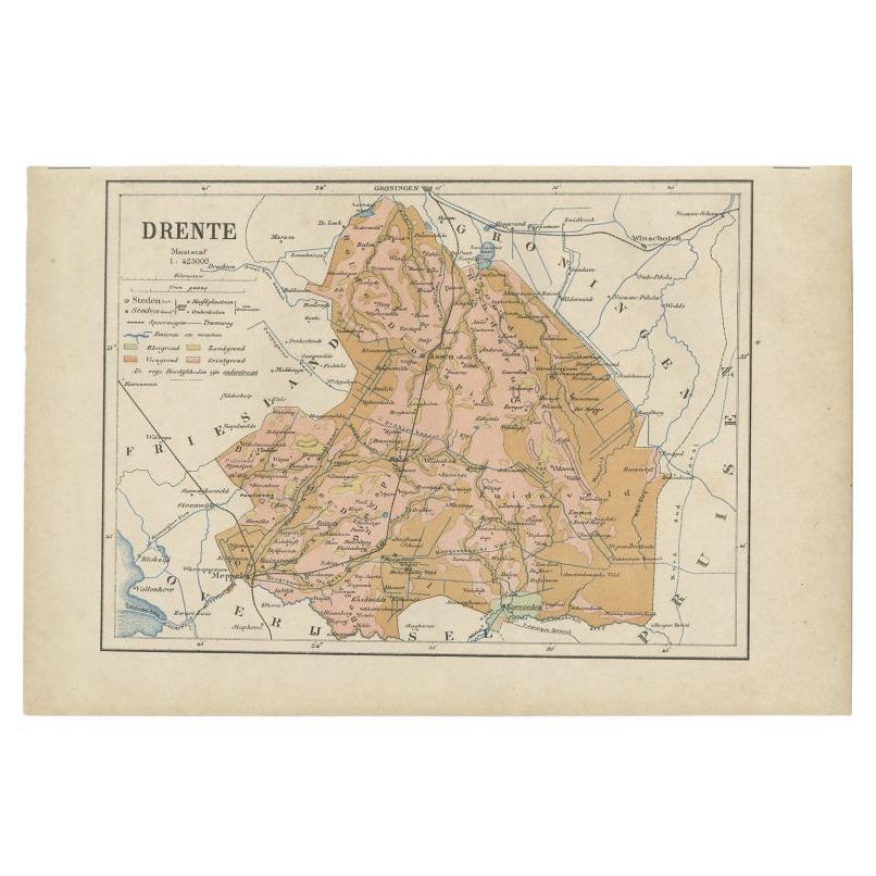
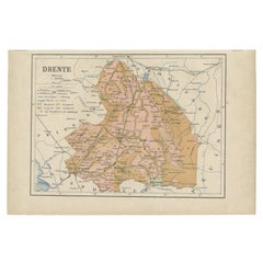
- Antique Map of Drenthe, Province in the Netherlands, 1883Located in Langweer, NLAntique map titled 'Drenthe'. Map of Drenthe, a province of the Netherlands. This map originates from 'Atlas van Nederland volgens de nieuwe spelregels' by J. Kuyper. Artists and ...Category
Antique 19th Century Maps
MaterialsPaper
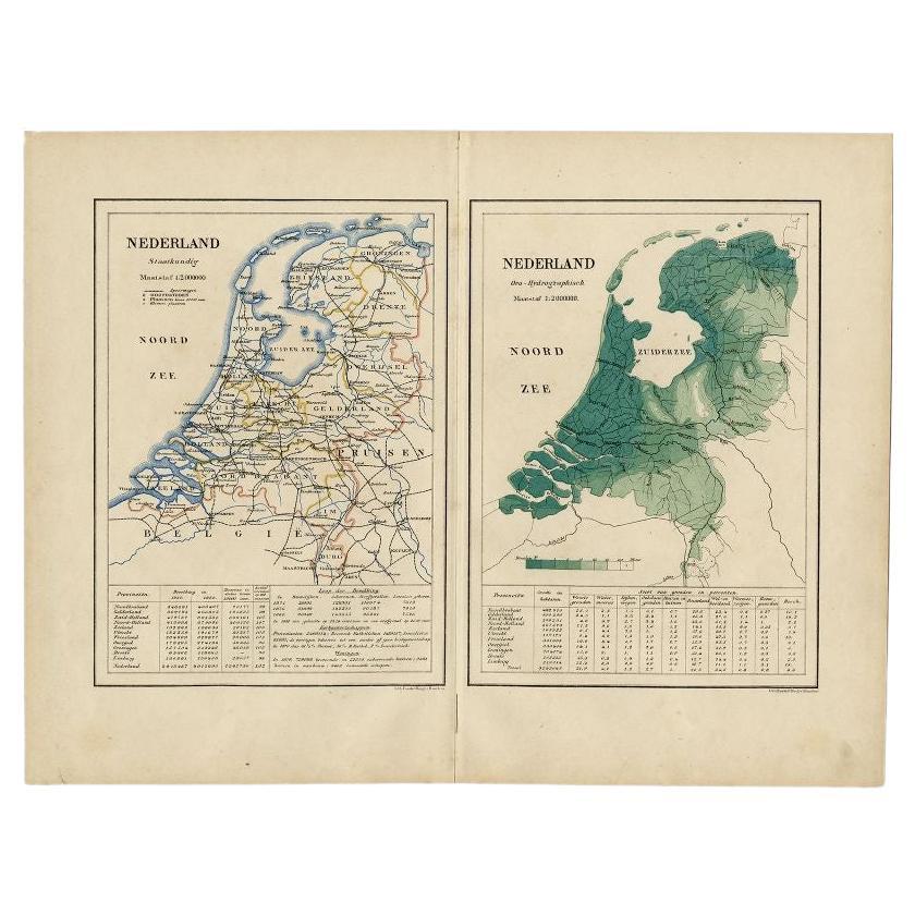
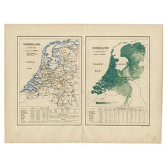
- Antique Map of the Netherlands by Kuyper, 1883Located in Langweer, NLAntique map titled 'Nederland Staatkundig - Nederland Oro-Hydrographisch'. Political and orohydrographic map of the Netherlands, two maps on one...Category
Antique 19th Century Maps
MaterialsPaper
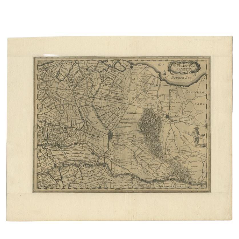
- Original Antique Map of Utrecht in the Netherlands by Blaeu, C.1645Located in Langweer, NLAntique map titled 'Ultraiectum Dominium'. Old map of the province of Utrecht, the Netherlands. This map originates from 'Theatrum Orbis Terrarum (..)'. Artists and Engravers: Wi...Category
Antique 17th Century Maps
MaterialsPaper
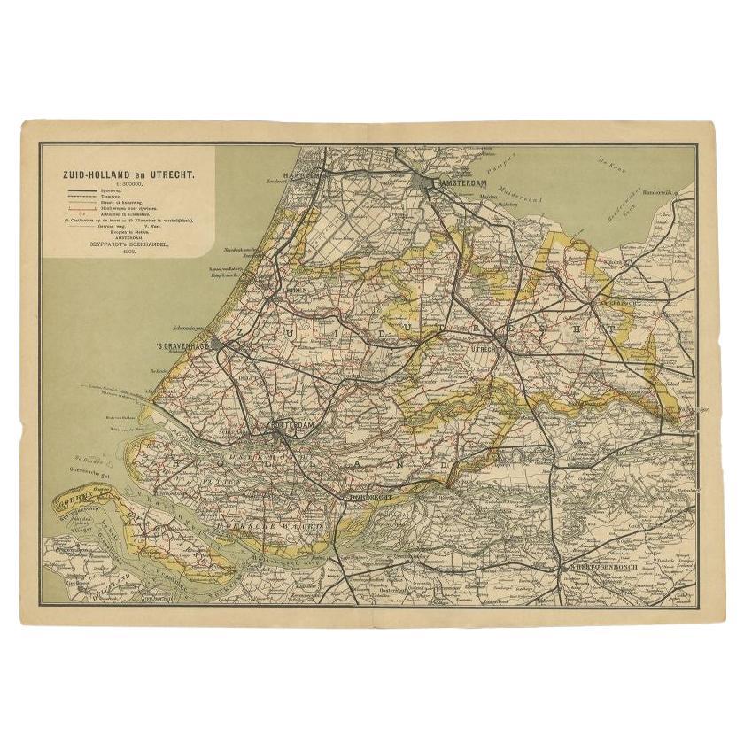
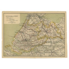
- Antique Map of Zuid-Holland and Utrecht in The Netherlands, 1902Located in Langweer, NLAntique map titled 'Zuid-Holland en Utrecht'. Lithographed map of the provinces of Zuid-Holland and Utrecht, the Netherlands. This map originates from 'Atlas van Nederland'. Artist...Category
20th Century Maps
MaterialsPaper
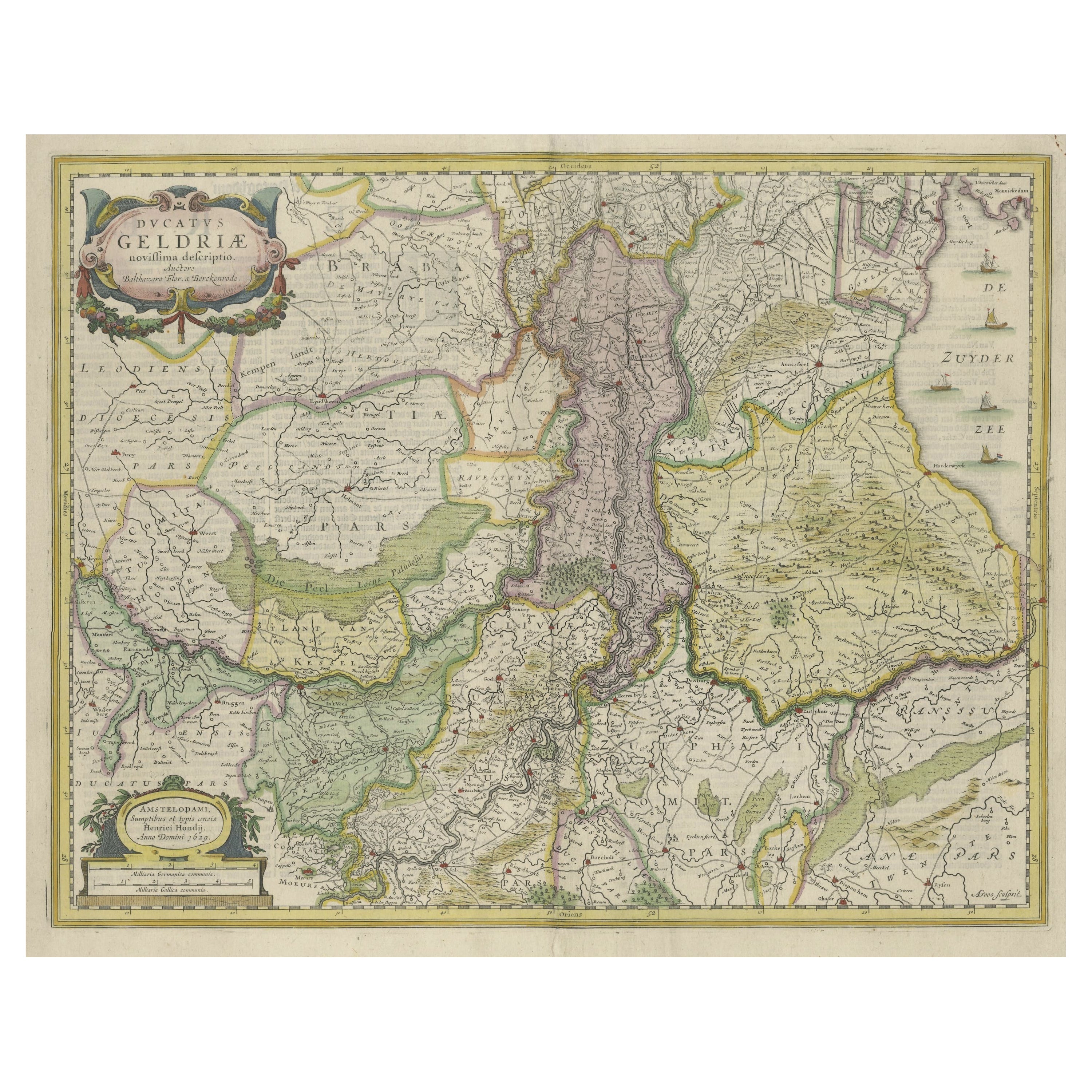
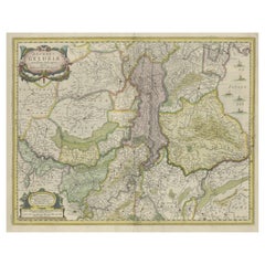
- Original Hand-Colored Antique Map of Gelderland and Utrecht in the NetherlandsLocated in Langweer, NLAntique map titled 'Ducatus Geldriae novissima descriptio'. Detailed map of Gelderland, a province in the Netherlands. Two coats of arms, one with scale. Ships on ‘De Zuyderzee’. Pub...Category
Antique Mid-17th Century Maps
MaterialsPaper
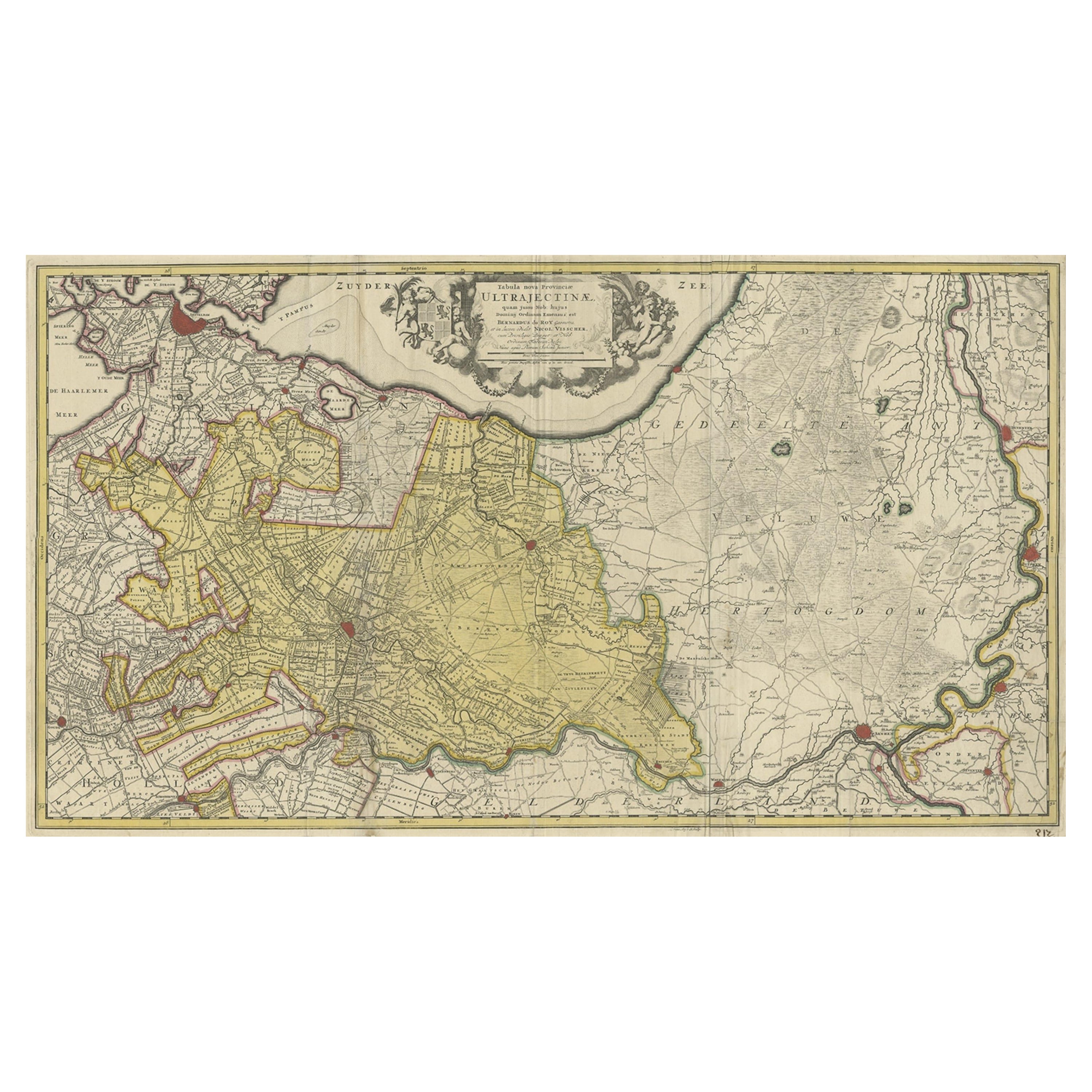
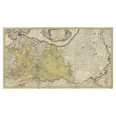
- Original Antique Map of the Province of Utrecht, the Netherlands, ca.1720Located in Langweer, NLAntique map titled ‘Tabula Nova Provinciae Ultrajectinae (..)’. Original antique map of the province of Utrecht, the Netherlands. It shows the region of Amsterdam, Utrecht, Gouda, ...Category
Antique 1720s Maps
MaterialsPaper

You May Also Like
- Original Antique Map of The Netherlands, Sherwood, Neely & Jones, Dated 1809Located in St Annes, LancashireGreat map of The Netherlands Copper-plate engraving by Cooper Published by Sherwood, Neely & Jones. Dated 1809 Unframed.Category
Antique Early 1800s English Maps
MaterialsPaper
- Original Antique Map of The Netherlands, Engraved by Barlow, Dated 1807Located in St Annes, LancashireGreat map of Netherlands Copper-plate engraving by Barlow Published by Brightly & Kinnersly, Bungay, Suffolk. Dated 1807 Unframed.Category
Antique Early 1800s English Maps
MaterialsPaper
- School Chart or Pull Down Map of Geography of the Netherlands, 1950sLocated in Hemiksem, VANA beautiful old school map of the Netherlands, painted on linen. The map shows the 3 different reliefs (low, middle, high) of the Netherlands. The beau...Category
Vintage 1950s Belgian Mid-Century Modern Maps
MaterialsLinen, Paint
- 1752 Vaugoundy Map of Flanders : Belgium, France, and the Netherlands, Ric.a002Located in Norton, MALarge Vaugoundy Map of Flanders: Belgium, France, and the Netherlands Colored -1752 Ric.a002 Description: This is a 1752 Didier Robert de Vaugondy map of Flanders. The map de...Category
Antique 17th Century Unknown Maps
MaterialsPaper
- 1861 Topographical Map of the District of Columbia, by Boschke, Antique MapLocated in Colorado Springs, COPresented is an original map of Albert Boschke's extremely sought-after "Topographical Map of the District of Columbia Surveyed in the Years 1856 ...Category
Antique 1860s American Historical Memorabilia
MaterialsPaper
- Original Antique Map of the American State of Pennsylvania, 1889Located in St Annes, LancashireGreat map of Pennsylvania Drawn and Engraved by W. & A.K. Johnston Published By A & C Black, Edinburgh. Original colour Unframed. Repair to a minor tear on bottom edge.Category
Antique 1880s Scottish Victorian Maps
MaterialsPaper


Recently Viewed
View AllMore Ways To Browse
Antique Map Livonia
Antique Maps Denver
Menorca Map
Sumba Map
Antique Cabbage Cutter
Wyld Globes
Antique Life Buoy
Antique Life Buoys
Atlantis Antique
Map Of Armenia
Gambia Antique Map
Victor Levasseur On Sale
Nova Totius
Antique Barbie Furniture
Antique Map Dordogne
Antique Yemen
Antique Map Montreal
Antique Map Of Puerto Rico