Items Similar to Original Hand-Colored Antique Map of Gelderland and Utrecht in the Netherlands
Want more images or videos?
Request additional images or videos from the seller
1 of 7
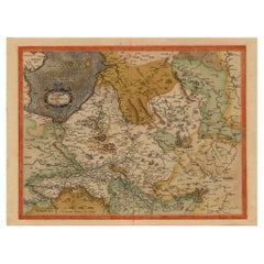
Original Hand-Colored Antique Map of Gelderland and Utrecht in the Netherlands
About the Item
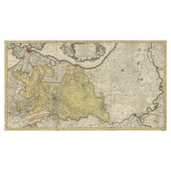
Antique map titled 'Ducatus Geldriae novissima descriptio'. Detailed map of Gelderland, a province in the Netherlands. Two coats of arms, one with scale. Ships on ‘De Zuyderzee’. Published by H. Hondius 1629.
- Dimensions:Height: 17.92 in (45.5 cm)Width: 21.86 in (55.5 cm)Depth: 0.02 in (0.5 mm)
- Materials and Techniques:
- Period:Mid-17th Century
- Date of Manufacture:1629
- Condition:Repaired. Wear consistent with age and use. General age-related toning, later hand coloring. Repair on verso, folding line flattened. Some wear and soiling. Dutch text on verso. Please study images carefully.
- Seller Location:Langweer, NL
- Reference Number:
About the Seller
5.0
Platinum Seller
These expertly vetted sellers are 1stDibs' most experienced sellers and are rated highest by our customers.
Established in 2009
1stDibs seller since 2017
1,946 sales on 1stDibs
Typical response time: <1 hour
- ShippingRetrieving quote...Ships From: Langweer, Netherlands
- Return PolicyA return for this item may be initiated within 14 days of delivery.
More From This SellerView All
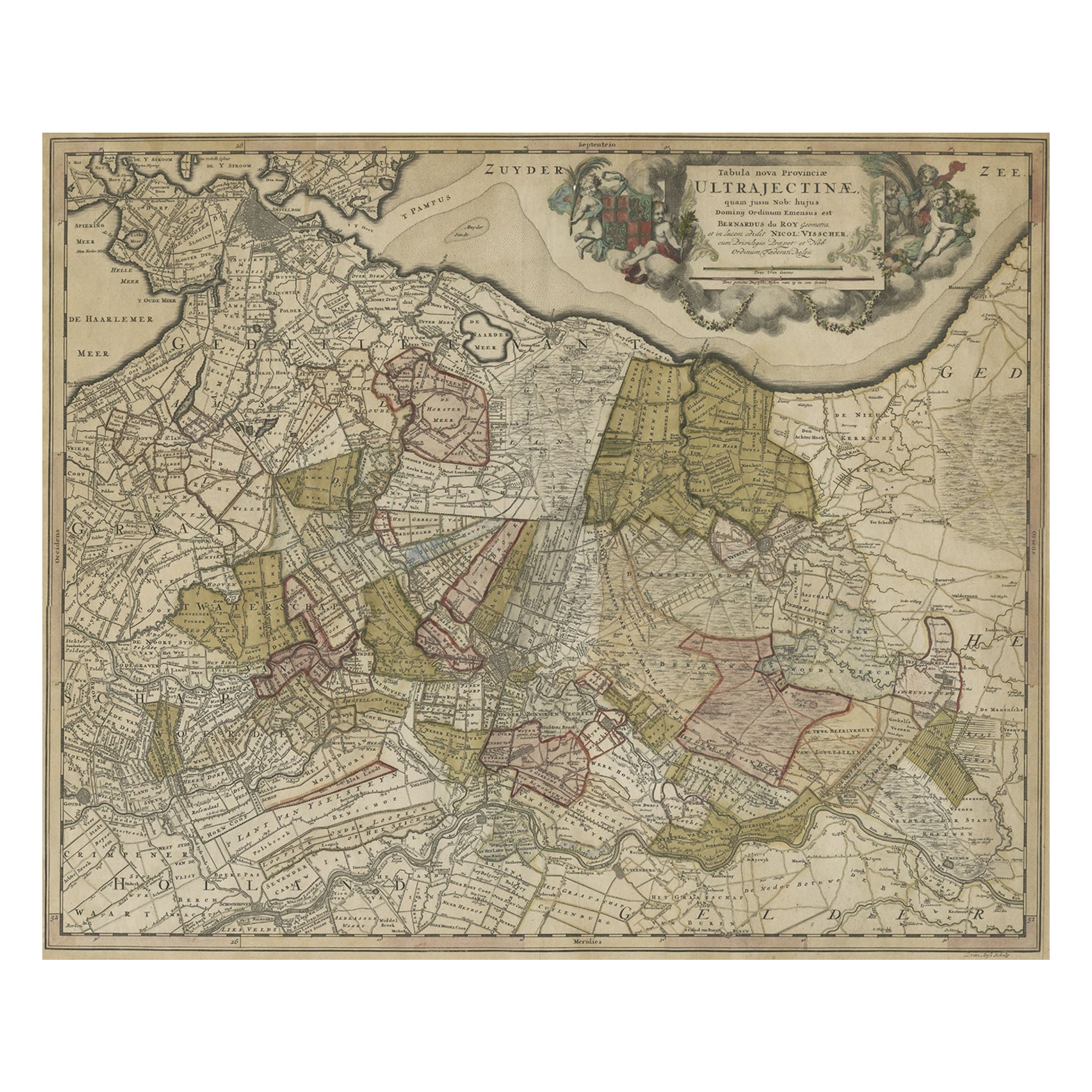
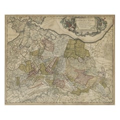
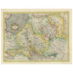
- Original Colored Antique Map of Utrecht & Surroundings, The Netherlands, c1690Located in Langweer, NLAntique map titled 'Tabula nova Provinciae Ultrajectinae quam jussu Nob: hujus Dominij Ordinum Emensus est Bernardus du Roy'. Map of the region of Utrecht, The Netherlands. This ...Category
Antique 1690s Maps
MaterialsPaper
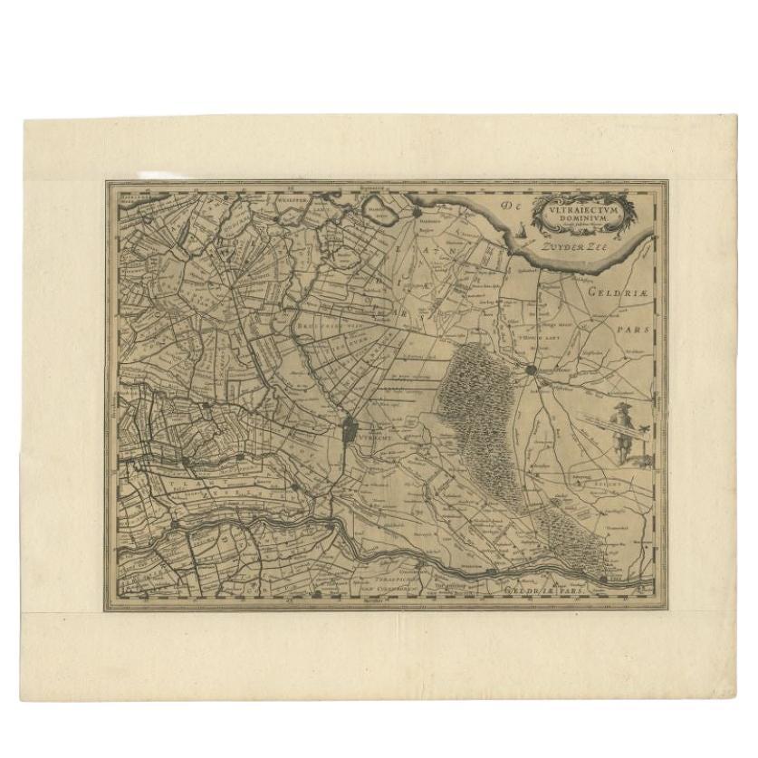
- Original Antique Map of Utrecht in the Netherlands by Blaeu, C.1645Located in Langweer, NLAntique map titled 'Ultraiectum Dominium'. Old map of the province of Utrecht, the Netherlands. This map originates from 'Theatrum Orbis Terrarum (..)'. Artists and Engravers: Wi...Category
Antique 17th Century Maps
MaterialsPaper
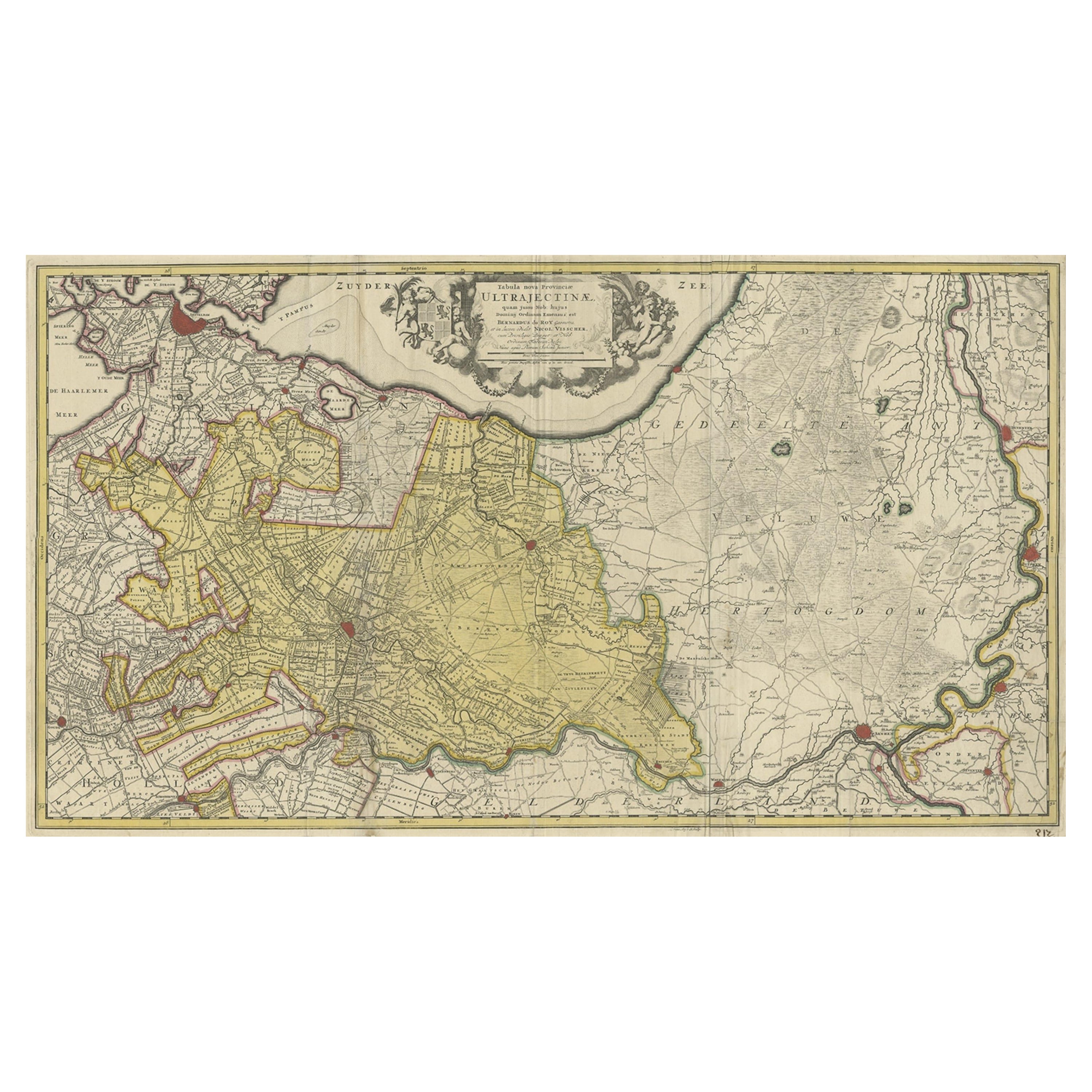
- Original Antique Map of the Province of Utrecht, the Netherlands, ca.1720Located in Langweer, NLAntique map titled ‘Tabula Nova Provinciae Ultrajectinae (..)’. Original antique map of the province of Utrecht, the Netherlands. It shows the region of Amsterdam, Utrecht, Gouda, ...Category
Antique 1720s Maps
MaterialsPaper
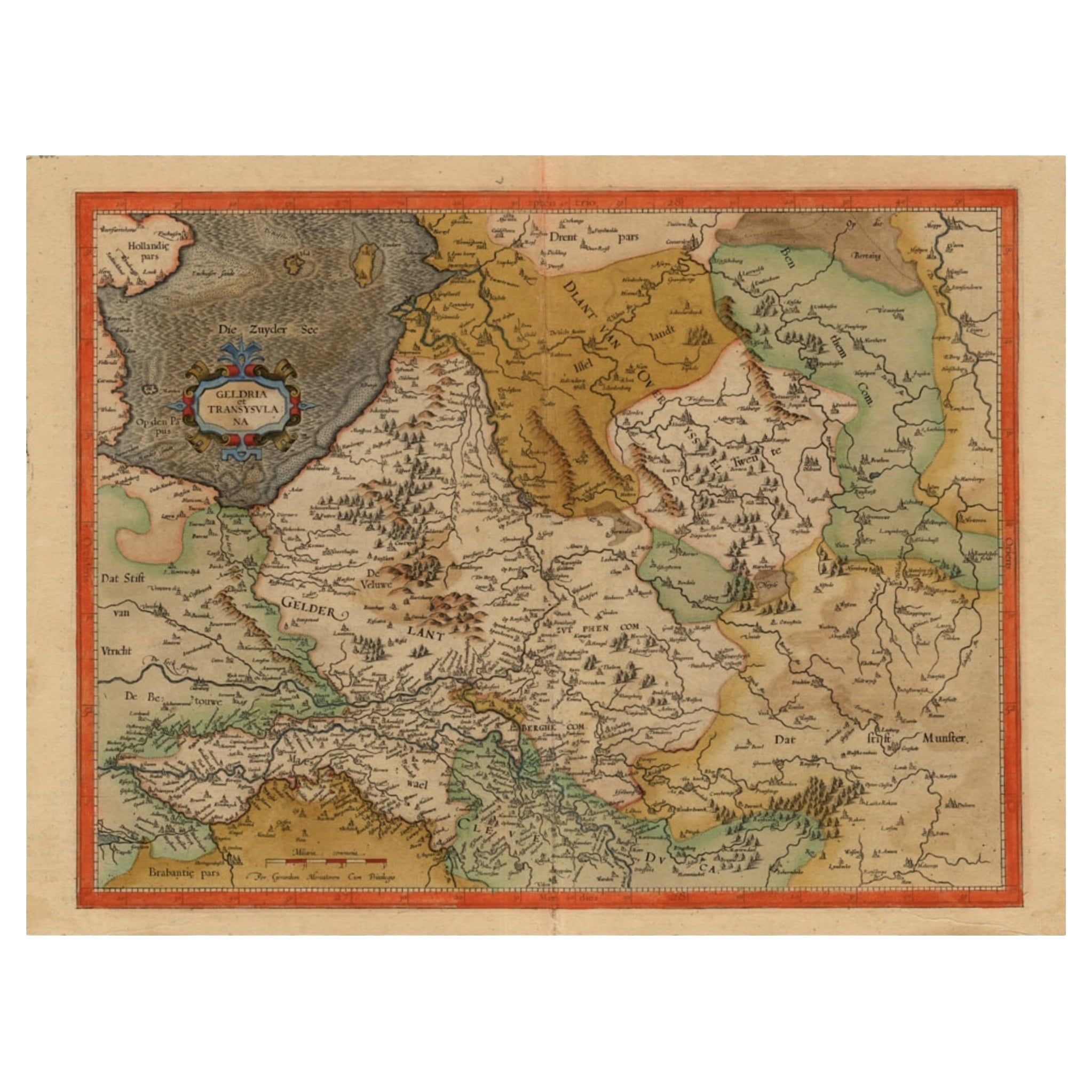
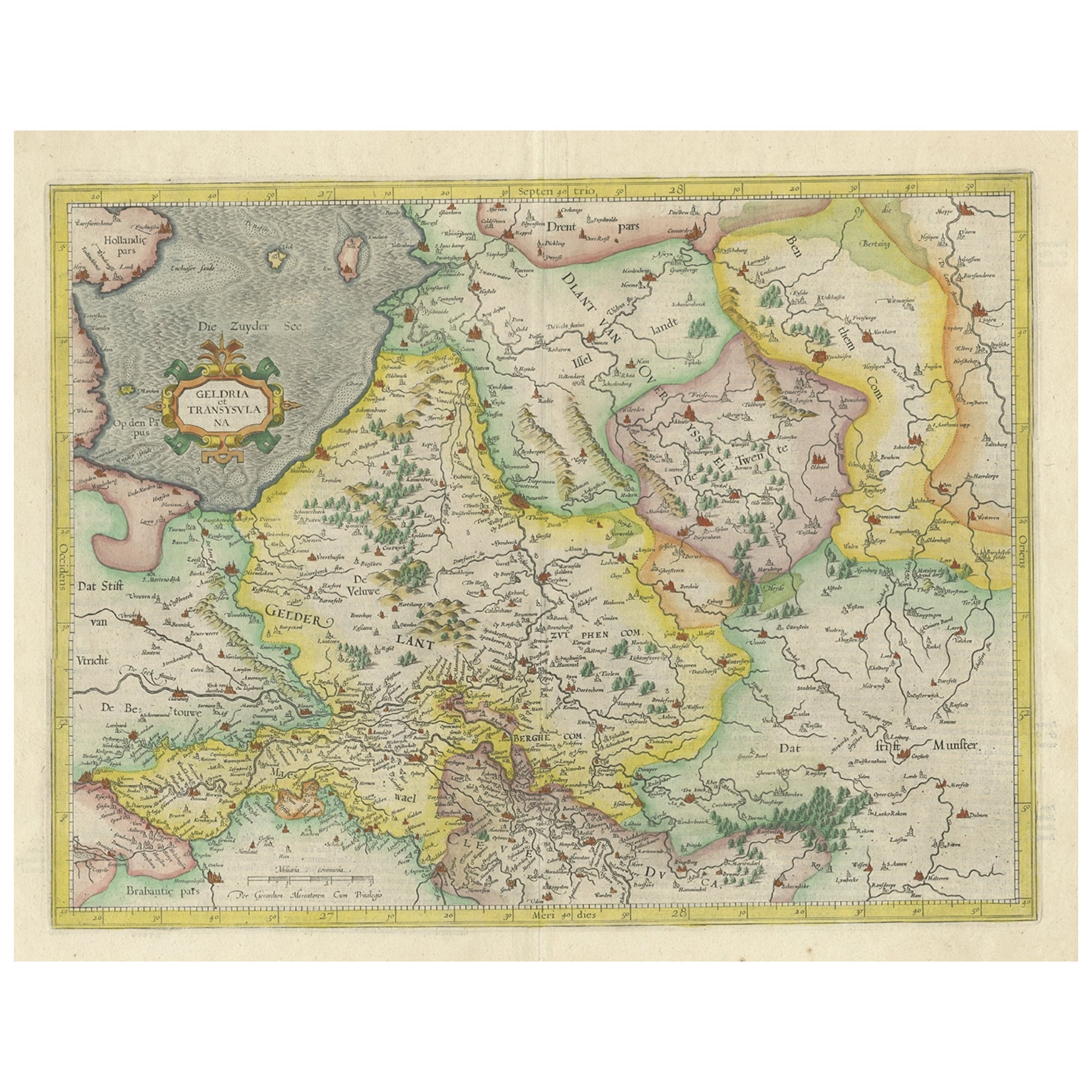
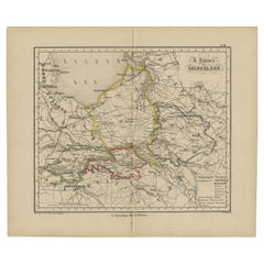
- Early Antique Map of Gelderland and Overijssel in the Netherlands, c.1625Located in Langweer, NLAntique map titled 'Geldria et Transysulana'. One of the earliest maps of Gelderland and Overijssel in the Netherlands, prepared by Gerard Mercator. Artists and Engravers: Gerard...Category
Antique 17th Century Maps
MaterialsPaper
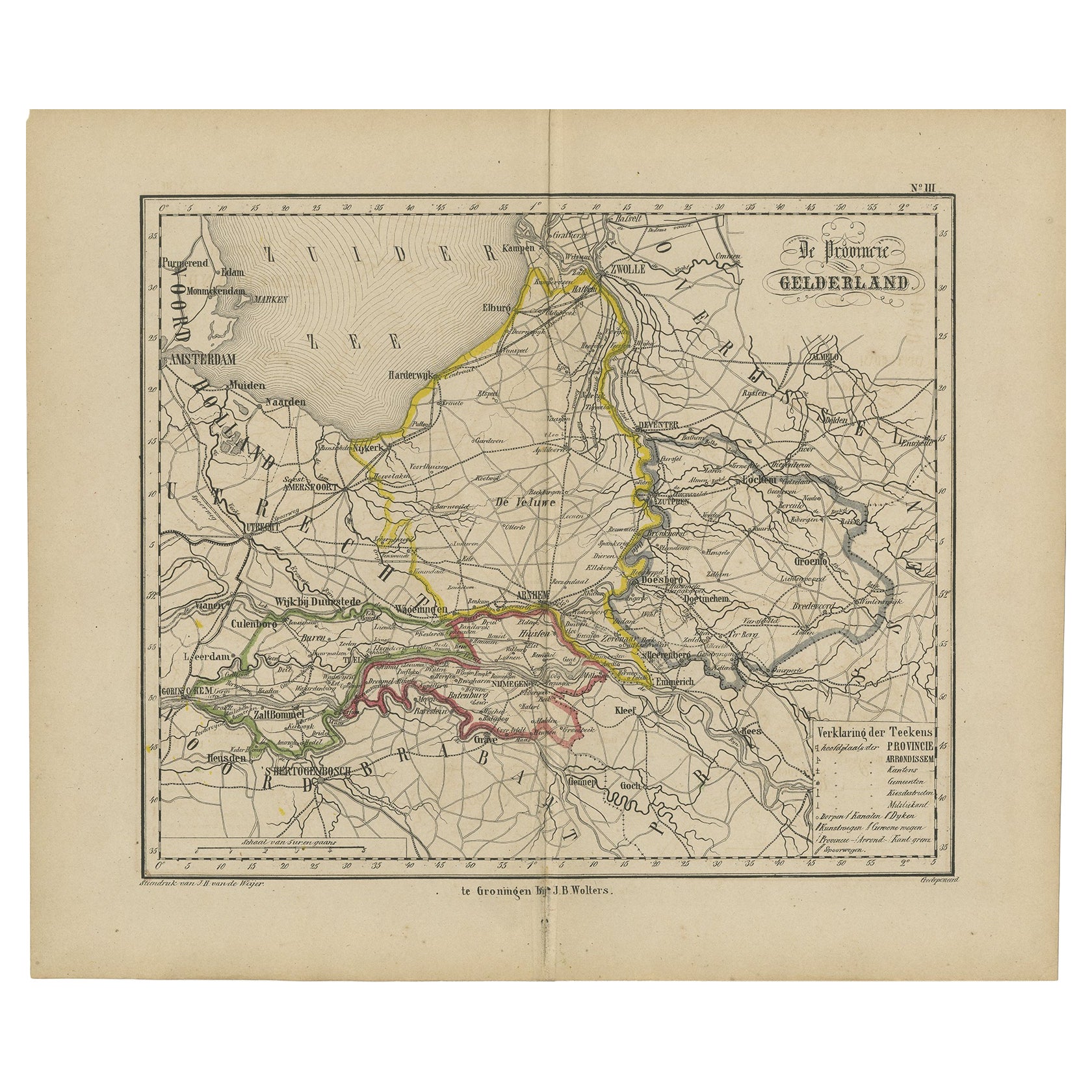
- Antique Map of Gelderland with the Veluwe Etc, the Netherlands, 1864Located in Langweer, NLAntique map titled 'De Provincie Gelderland'. Map of the province of Gelderland, the Netherlands. This map originates from 'F. C. Brugsma's Atlas van het Koninkrijk der Nederland...Category
Antique 19th Century Maps
MaterialsPaper
- One of the Earliest Maps of Gelderland and Overijssel in the Netherlands, 1623Located in Langweer, NLAntique map titled 'Geldria et Transysulana'. One of the earliest maps of Gelderland and Overijssel in the Netherlands, prepared by Gerard Mercator. Artists and Engravers: Ger...Category
Antique 1620s Maps
MaterialsPaper

You May Also Like
- Original Antique Map of The Netherlands, Engraved by Barlow, Dated 1807Located in St Annes, LancashireGreat map of Netherlands Copper-plate engraving by Barlow Published by Brightly & Kinnersly, Bungay, Suffolk. Dated 1807 Unframed.Category
Antique Early 1800s English Maps
MaterialsPaper
- Hand-Colored 18th Century Homann Map of Denmark and Islands in the Baltic SeaBy Johann Baptist HomannLocated in Alamo, CAAn 18th century copper plate hand-colored map entitled "Insulae Danicae in Mari Balthico Sitae utpote Zeelandia, Fionia, Langelandia, Lalandia, Falstria, Fembria Mona" created by Joh...Category
Antique Early 18th Century German Maps
MaterialsPaper
- 17th Century Hand Colored Map of the Liege Region in Belgium by VisscherBy Nicolaes Visscher IILocated in Alamo, CAAn original 17th century map entitled "Leodiensis Episcopatus in omnes Subjacentes Provincias distincté divisusVisscher, Leodiensis Episcopatus" by Nicolaes Visscher II, published in Amsterdam in 1688. The map is centered on Liege, Belgium, includes the area between Antwerp, Turnhout, Roermond, Cologne, Trier and Dinant. This attractive map is presented in a cream-colored mat measuring 30" wide x 27.5" high. There is a central fold, as issued. There is minimal spotting in the upper margin and a tiny spot in the right lower margin, which are under the mat. The map is otherwise in excellent condition. The Visscher family were one of the great cartographic families of the 17th century. Begun by Claes Jansz Visscher...Category
Antique Late 17th Century Dutch Maps
MaterialsPaper
- The Normandy Region of France: A 17th C. Hand-colored Map by Sanson and JaillotBy Nicolas SansonLocated in Alamo, CAThis large hand-colored map entitled "Le Duché et Gouvernement de Normandie divisée en Haute et Basse Normandie en divers Pays; et par evêchez, avec le Gouvernement General du Havre ...Category
Antique 1690s French Maps
MaterialsPaper
- Hand Colored 18th Century Homann Map of Austria Including Vienna and the DanubeBy Johann Baptist HomannLocated in Alamo, CA"Archiducatus Austriae inferioris" is a hand colored map of Austria created by Johann Baptist Homann (1663-1724) and published in Nuremberg, Germany in 1728 shortly after his death. ...Category
Antique Early 18th Century German Maps
MaterialsPaper
- The Kingdom of Naples and Southern Italy: A Hand-Colored 18th Century Homann MapBy Johann Baptist HomannLocated in Alamo, CA"Novissima & exactissimus Totius Regni Neapolis Tabula Presentis Belli Satui Accommo Data" is a hand colored map of southern Italy and the ancient Kingdom of Naples created by Johann...Category
Antique Early 18th Century German Maps
MaterialsPaper


Recently Viewed
View AllMore Ways To Browse
Hand Colored Antique
Victorian Fence
Battle Maps
Russian Antique Plates
Floor Vase Wood
Mariner Furniture
Map Print Set
Antique World Globe Map
Antique Blackwood
Antique Furniture Missouri
Roman Map
Antique Marine Maps
Antique Indian Maps
Antique Africa Maps And Atlases Africa Maps
Antique Maps California
Antique Map California
Map Of Sweden
Antique Maps Of California