Items Similar to Antique Plan of Philippeville in Wallonia, Belgium, 1769


Want more images or videos?
Request additional images or videos from the seller
1 of 6
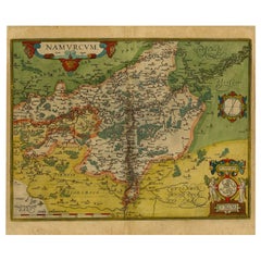
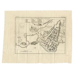
Antique Plan of Philippeville in Wallonia, Belgium, 1769
About the Item
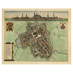
Antique map titled 'Philippe-Ville'. Plan of Philippeville in Wallonia, Belgium. This print originates from volume 3 of 'Les Delices des Pays-Bas ou description geographique et historique des XVII. provinces'.
Artists and Engravers: Engraved by J. Harrewijn (signed). Published by J. F. Bassompierre, Liege.
Condition: Very good, general age-related toning. Please study image carefully.
Date: 1769
Overall size: 22.5 x 17.5 cm.
Image size: 18.5 x 14 cm.
We sell original antique maps to collectors, historians, educators and interior decorators all over the world. Our collection includes a wide range of authentic antique maps from the 16th to the 20th centuries. Buying and collecting antique maps is a tradition that goes back hundreds of years. Antique maps have proved a richly rewarding investment over the past decade, thanks to a growing appreciation of their unique historical appeal. Today the decorative qualities of antique maps are widely recognized by interior designers who appreciate their beauty and design flexibility. Depending on the individual map, presentation, and context, a rare or antique map can be modern, traditional, abstract, figurative, serious or whimsical. We offer a wide range of authentic antique maps for any budget.
- Dimensions:Height: 6.89 in (17.5 cm)Width: 8.86 in (22.5 cm)Depth: 0 in (0.01 mm)
- Materials and Techniques:
- Period:
- Date of Manufacture:1769
- Condition:Condition: Very good, general age-related toning. Please study image carefully.
- Seller Location:Langweer, NL
- Reference Number:
About the Seller
5.0
Platinum Seller
These expertly vetted sellers are 1stDibs' most experienced sellers and are rated highest by our customers.
Established in 2009
1stDibs seller since 2017
1,922 sales on 1stDibs
Typical response time: <1 hour
- ShippingRetrieving quote...Ships From: Langweer, Netherlands
- Return PolicyA return for this item may be initiated within 14 days of delivery.
More From This SellerView All
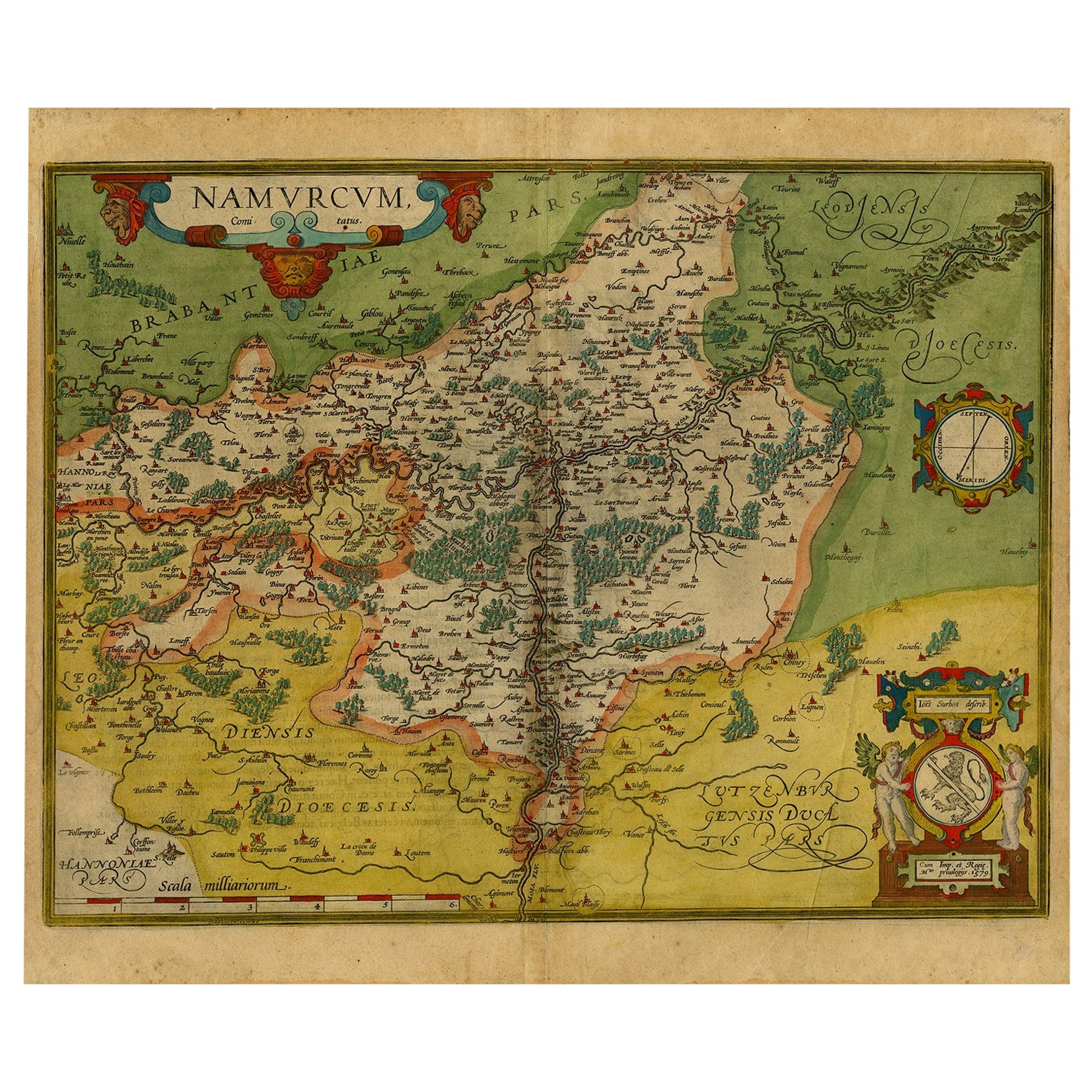
- Antique Map of the Namen or Namur Region in Wallonia, BelgiumLocated in Langweer, NLDescription: Antique map titled 'Namurcum Comitatus' A map of the Namen/Namur region in Wallonia, Belgium. It is the capital of the province Namur and hosts the Walloon Parliament. T...Category
Antique 1610s Maps
MaterialsPaper
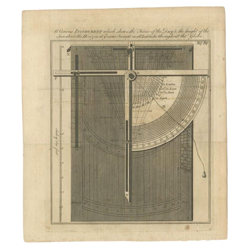
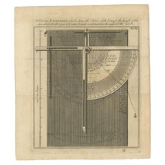
- Antique Print of a Scientific Instrument, 1769Located in Langweer, NLAntique print titled 'A curious Instrument which shews the Hour of the Day (..)'. Print of a scientific instrument. This print originates from 'The Gentleman's Magazine'. Artists a...Category
Antique 18th Century Prints
MaterialsPaper
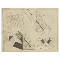
- Antique Engraving of Constructing Sun Dials, 1769Located in Langweer, NLAntique print of Ferguson's method of constructing sun dials. This print originates from 'The Gentleman's Magazine'. Artists and Engravers: The Gentleman'...Category
Antique 18th Century Prints
MaterialsPaper
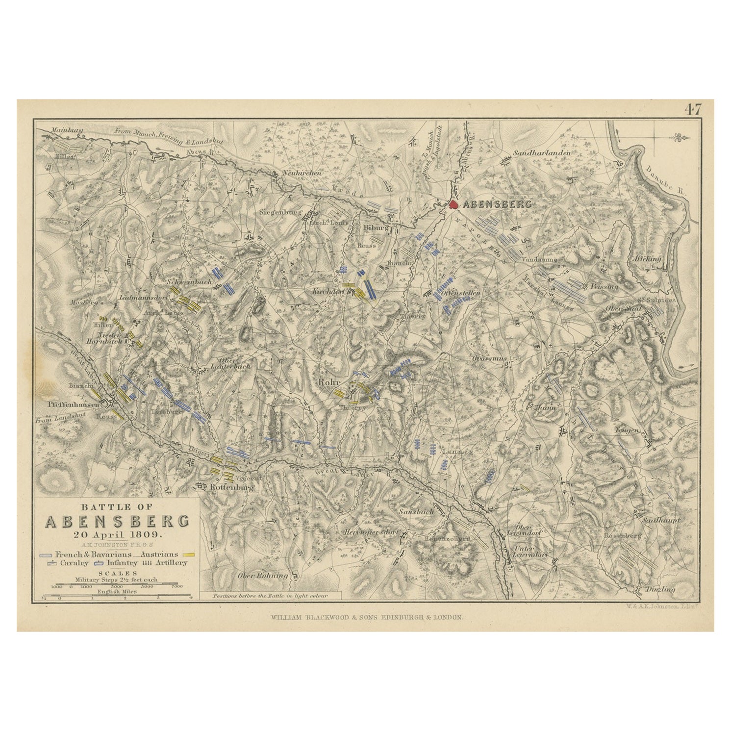
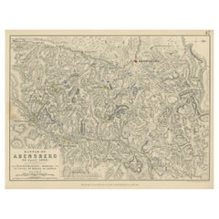
- Antique Plan of the Battle of Abensberg in GermanyLocated in Langweer, NLAntique battle map titled 'Battle of Abensberg 20 April 1809'. Plan of the Battle of Abensberg, fought on 20 April 1809 between a Franco-German force under ...Category
Antique Mid-19th Century Maps
MaterialsPaper
- Decorative Bird's-Eye View Plan of Ieper or Ypres in Belgium, 1649Located in Langweer, NLAntique print, titled: 'Ypra.' Bird's-eye view plan of Ieper / Ypres in Belgium. With key to locations and coats of arms. Text in Latin on verso. This plan originates from the famous city Atlas: 'Toneel der Steeden' published by Joan Blaeu...Category
Antique 1640s Maps
MaterialsPaper
- Antique Plan of Ancient Syracuse, Plan of ancient Syracuse, Sicily, ItalyLocated in Langweer, NLAntique print titled 'Plan de l'Ancienne Ville de Syracuse'. Plan of ancient Syracuse, Sicily, Italy. This print originates from 'Histoire Universelle (..)'. Artists and Engravers...Category
Antique 18th Century Maps
MaterialsPaper
You May Also Like
- Original Antique City Plan of Milwaukee, USA, 1894By Rand McNally & Co.Located in St Annes, LancashireFabulous colorful map of Milwaukee Original color By Rand, McNally & Co. Published, 1894 Unframed Free shipping.Category
Antique 1890s American Maps
MaterialsPaper
- Plan of Paris, France, by A. Vuillemin, Antique Map, 1845Located in Colorado Springs, COThis large and detailed plan of Paris was published by Alexandre Vuillemin in 1845. The map conveys a wonderful amount of information and is decorated throughout with pictorial vigne...Category
Antique 1840s American Maps
MaterialsPaper
- Original Antique City Plan of Kansas City, USA. 1894By Rand McNally & Co.Located in St Annes, LancashireFabulous colorful map of Kansas City Original color By Rand, McNally & Co. Published, 1894 Unframed Slightly reduced bottom margin. Free shipping.Category
Antique 1890s American Maps
MaterialsPaper
- Antique "New Plan of London" Map by John Bartholomew, 1900Located in Bridgeport, CTProduced for the W.H. Smith guide, folded in the original. The map here is unfolded and framed flat, with transportation routes shown and color details. sight 22 x 32" (original ful...Category
Antique Early 1900s English Victorian Maps
MaterialsPaper
- Large Original Antique City Plan of Dublin, Ireland, circa 1880Located in St Annes, LancashireGreat city plan of Dublin Published circa 1880 Unframed Free shipping. .Category
Antique 1880s Scottish Maps
MaterialsPaper
- Large Original Antique City Plan of Philadelphia, USA, circa 1900By Rand McNally & Co.Located in St Annes, LancashireFabulous colorful map of Philadelphia Original color By Rand, McNally & Co. Published, circa 1900. Unframed Free shipping.Category
Antique Early 1900s American Maps
MaterialsPaper


Recently Viewed
View AllMore Ways To Browse
Cambodia Antique Map
Antique Map Singapore
Guyana Antique Map
Antique Map Vietnam
Antique Maps Michigan
Puerto Rico Map
Wisconsin Map
Antique Map Sydney
Antique Maps Sydney
J Beringer
Antique Map Of Michigan
Antique Wisconsin Maps
Bedfordshire Antique Map
Herefordshire Antique Map
Antique Furniture Pondicherry
Antique Indiana Map
Antique Maps Rhode Island
Buckinghamshire Antique Map