Items Similar to Antique "New Plan of London" Map by John Bartholomew, 1900


Want more images or videos?
Request additional images or videos from the seller
1 of 10
Antique "New Plan of London" Map by John Bartholomew, 1900
About the Item
Produced for the W.H. Smith guide, folded in the original. The map here is unfolded and framed flat, with transportation routes shown and color details.
sight 22 x 32" (original full paper 23 x 33")
Custom framed in wood (Minor acceptable wear) 32 1/2”x 41 3/4" x .75” deep.
Condition: folds overall with some tiny holes and tears from use as well as some expected age spotting (Please see photos) however the Map presenting very well.
- Dimensions:Height: 32.5 in (82.55 cm)Width: 41.75 in (106.05 cm)Depth: 0.75 in (1.91 cm)
- Style:Victorian (Of the Period)
- Materials and Techniques:
- Place of Origin:
- Period:1900-1909
- Date of Manufacture:1900
- Condition:Wear consistent with age and use.
- Seller Location:Bridgeport, CT
- Reference Number:
About the Seller
5.0
Vetted Seller
These experienced sellers undergo a comprehensive evaluation by our team of in-house experts.
1stDibs seller since 2015
1,590 sales on 1stDibs
Typical response time: <1 hour
- ShippingRetrieving quote...Ships From: Bridgeport, CT
- Return PolicyThis item cannot be returned.
More From This SellerView All
- Framed 1731 Color Engraving, Map of Rotterdam by Matthaus Seutter, "Roterodami"Located in Bridgeport, CT"Roterodami". Seutter (1678-1757) was an important German 18th century map maker. Bird's eye view of the city above with full details, neoclassi...Category
Antique 18th Century European Renaissance Maps
MaterialsGlass, Wood, Paper
- Matthaus Seutter, Framed 1730 Color Engraving Map of "Belgium Fonderatum"Located in Bridgeport, CTLabel on verso. From Grosser Atlas. The name Belgium comes from the ancient designation "Gallis Belgica". Figural decoration upper left. M. Seutter was a famed German mapmaker in the...Category
Antique 18th Century European Renaissance Maps
MaterialsBrass
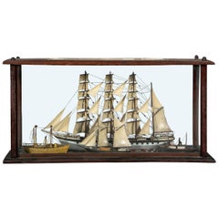
- Antique Shadowbox Diorama of Ship ModelsLocated in Bridgeport, CTAn impressive and unusual 19th century cased ship diorama displaying four ships at sea. A four masted schooner sets the background with a tug boat, two masted vessel and a steamship ...Category
Antique 19th Century American Classical Nautical Objects
MaterialsWood
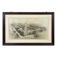
- Antique Rendering of a Photo of Yale Locks-Hardware, Stamford ConnecticutLocated in Bridgeport, CTAntique circa 1897 rendering of an Aerial photograph view of the huge complex of the manufacturing company formerly residing in Stamford, Connecticut. Image measures 18 3/4 x 34 1/4...Category
Antique Late 19th Century American Industrial Historical Memorabilia
MaterialsWood
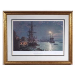
- John Stobart (English, B. 1929), Independence, Ltd. Ed. SignedBy John StobartLocated in Bridgeport, CT"John Stobart (British b. 1929) paintings and limited edition prints are collected around the world and seen by visitors of the Peabody Museum in Massachusetts and the Portland Museum in Maine. He is well known maritime artist known for images of ports and vessels as they were in the great era of sail and stream". INDEPENDENCE, Wayne City Landing, Start of the Santa Fe Trail...Category
20th Century American Classical Prints
MaterialsGlass, Wood, Paper
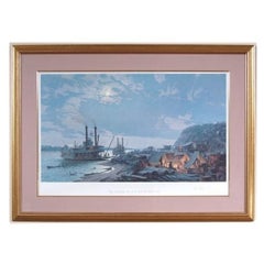
- John Stobart 'English, B. 1929', Savannah, Ltd. Ed, Signed PrintBy John StobartLocated in Bridgeport, CT"John Stobart (British b. 1929) paintings and limited edition prints are collected around the world and seen by visitors of the Peabody Museum in Massachusetts and the Portland Museum in Maine. He is well known maritime artist known for images of ports and vessels as they were in the great era of sail and stream". SAVANNAH Moonlight over the Savannah River in 1850 depicting a view of Savannah...Category
20th Century American Classical Prints
MaterialsGlass, Wood, Paper


You May Also Like
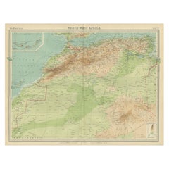
- Antique Map of Northwest Africa by Bartholomew, 1922Located in Langweer, NLAntique map of Africa titled 'North-West Africa'. Old map of north-west Africa depicting Morocco, Algeria, Tunis and surroundings. This map originates from 'The Times' atlas. Artists...Category
20th Century Maps
MaterialsPaper
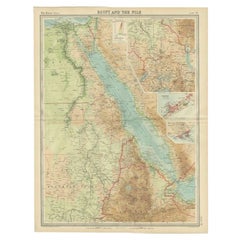
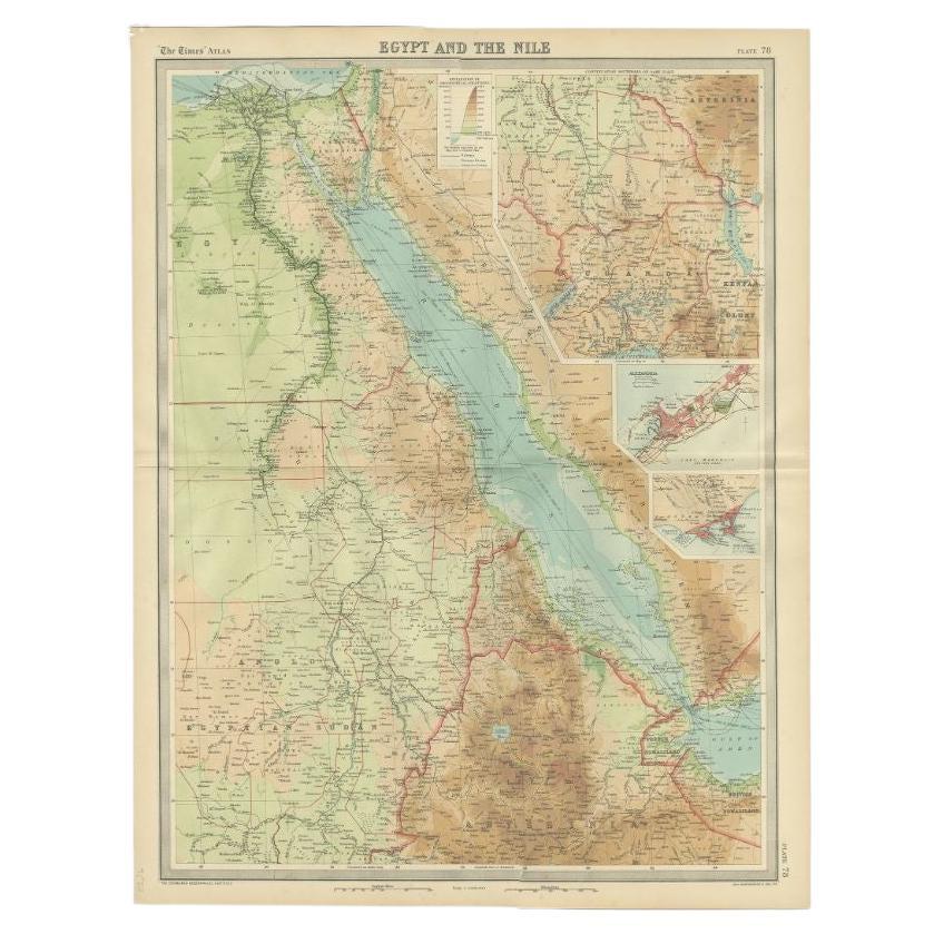
- Antique Map of the Region of the Nile River by Bartholomew, 1922Located in Langweer, NLAntique map of Africa titled 'Egypt and the Nile'. Old map of Africa depicting Egypt, the Nile river and surroundings. This map originates from 'The Times' ...Category
20th Century Maps
MaterialsPaper
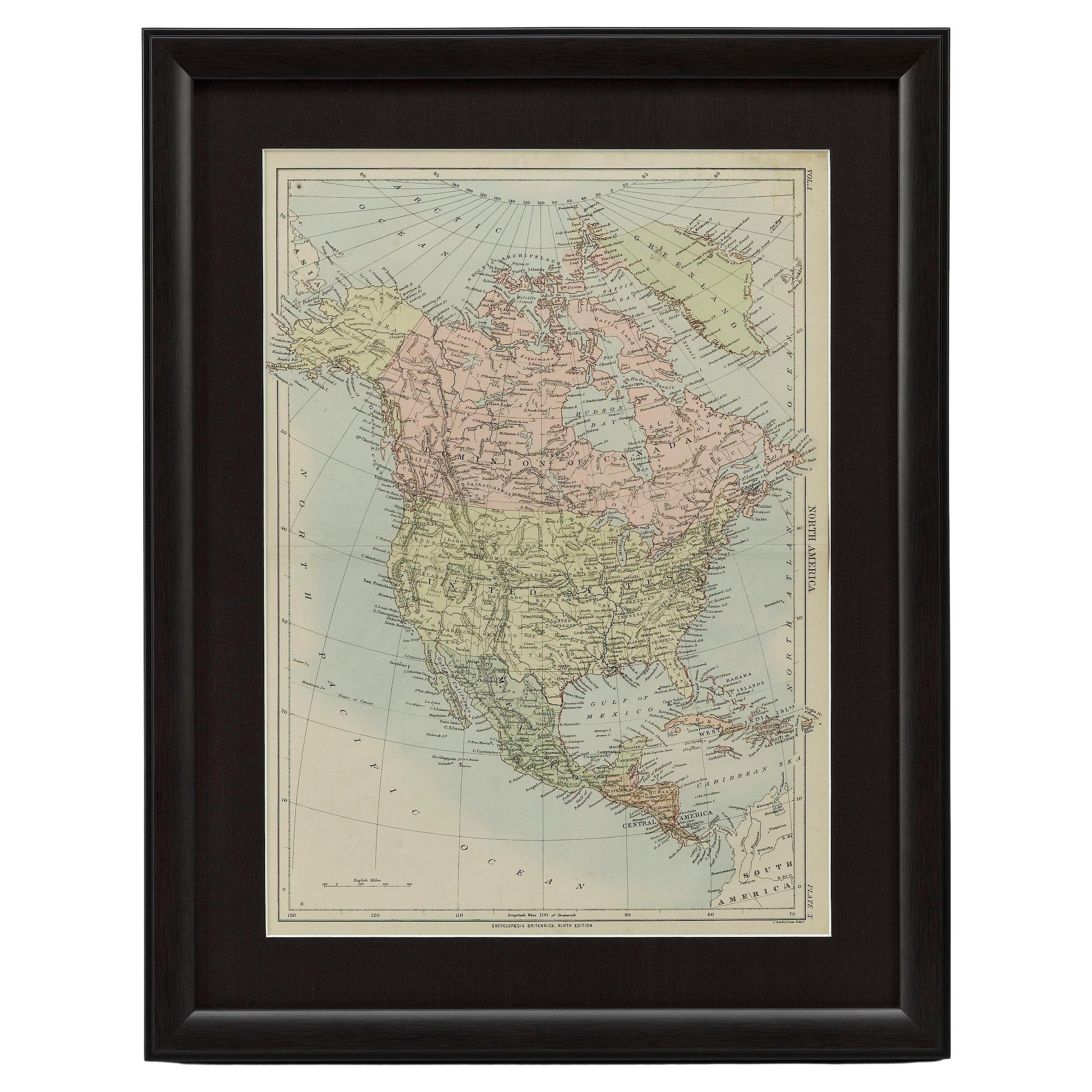
- 1875 "North America" Map by J. BartholomewLocated in Colorado Springs, COPresented is an original 1875 map of “North America.” The map was issued in Volume 1 of the Ninth Edition of the Encyclopædia Britannica, published in Edinburgh. The map was drawn by famous Scottish mapmaker John Bartholomew. The map depicts North America, to include Greenland, the Dominion of Canada, the United States, Mexico, the countries of Central America, and the islands of the West Indies. Prominent rivers, mountain ranges, and cities are labeled on the map, and country borders are emphasized in red. The Encyclopædia Britannica has been published continuously since 1768, appearing in fifteen official editions. The landmark ninth edition of the Encyclopædia Britannica, often called "the Scholar's Edition," was published from January 1875 to 1889 in 25 volumes. The editor and author of the “Foreword” was Thomas Spencer Baynes, the first English-born editor after a series of Scots. After 1880, Baynes was assisted by William Robertson Smith. The 9th edition is often lauded as a high point among early editions for scholarship. The 9th edition was far more luxurious than any previously printed Encyclopædia Britannicas, with thick boards and quality leather bindings, premier paper, and a production which took full advantage of the technological advances of printing in the years between the 1850s and 1870s. The publishers took advantage of the new ability to print large graphic illustrations on the same pages as the text, as opposed to limiting illustrations to separate copper plate engravings. Although this technology had first been used in a primitive fashion the 7th edition, and to a much lesser extent in the 8th, in the 9th edition there were thousands of quality illustrations and maps set...Category
Antique 1870s Scottish Maps
MaterialsPaper
- Antique Map of London by Tirion '1754'Located in Langweer, NLAntique map titled 'Kaart van Londen enz. en van het naby gelegen land ruim een Uur gaans rondsom dezelve Stad; getrokken uit de groote gemeeten Kaart van Hr. John Rocque'. In the se...Category
Antique Mid-18th Century Maps
MaterialsPaper
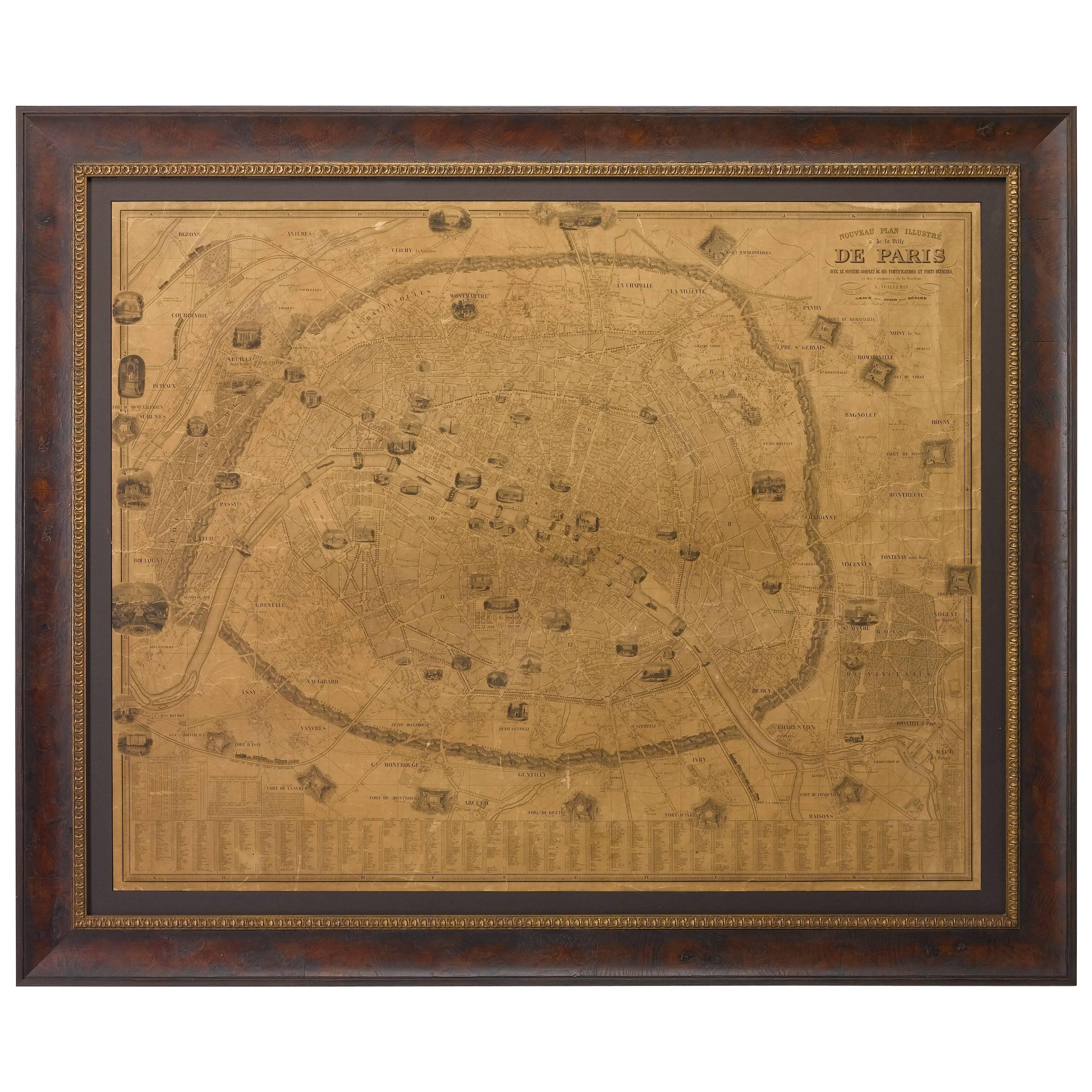
- Plan of Paris, France, by A. Vuillemin, Antique Map, 1845Located in Colorado Springs, COThis large and detailed plan of Paris was published by Alexandre Vuillemin in 1845. The map conveys a wonderful amount of information and is decorated throughout with pictorial vigne...Category
Antique 1840s American Maps
MaterialsPaper
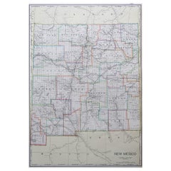
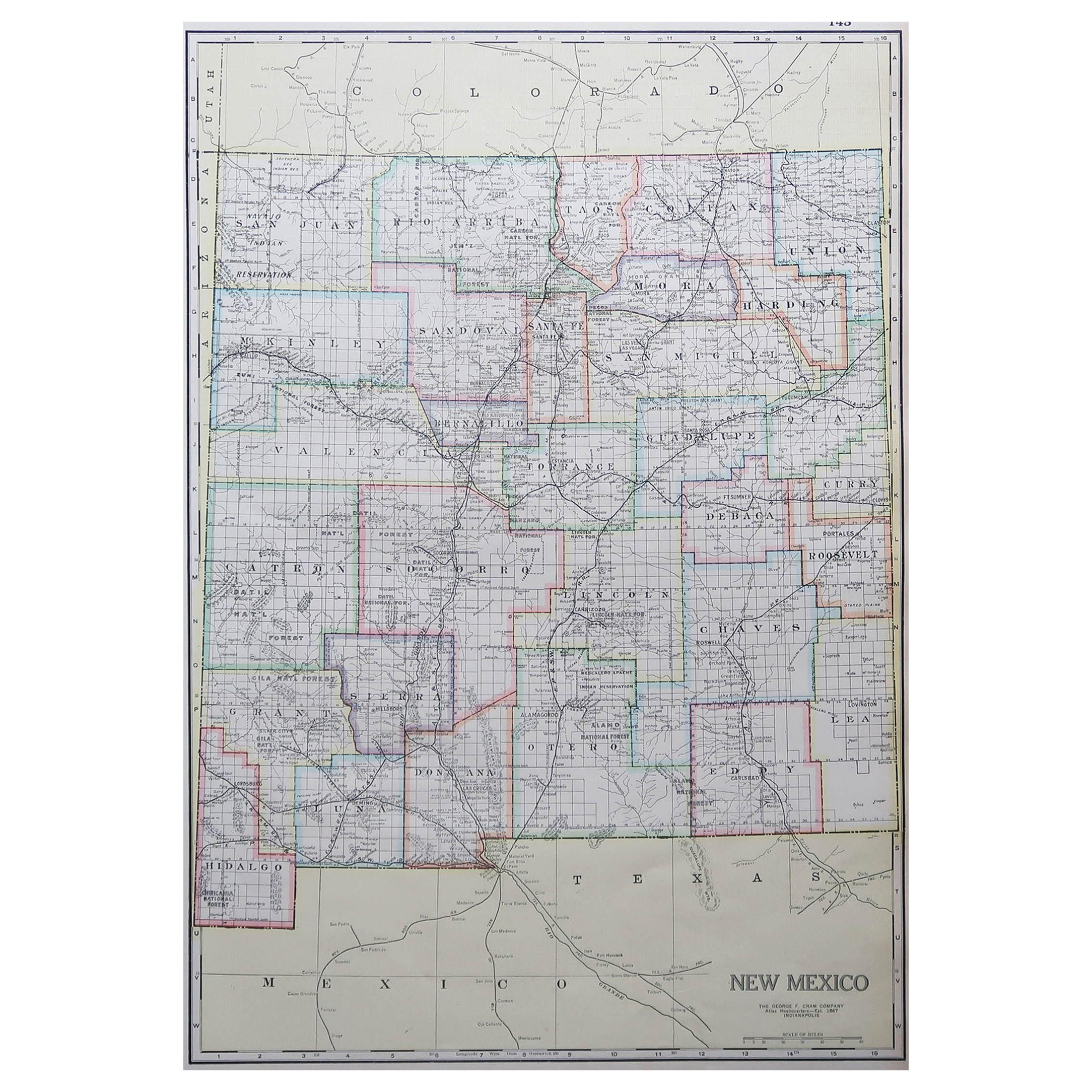
- Large Original Antique Map of New Mexico, Usa, C.1900Located in St Annes, LancashireFabulous map of New Mexico. Original color. Engraved and printed by the George F. Cram Company, Indianapolis. Published, C.1900. Unframed. Free shipping.Category
Antique 1890s American Maps
MaterialsPaper