Items Similar to Antique Print with Charts of York's Bay and Surroundings

Want more images or videos?
Request additional images or videos from the seller
1 of 6
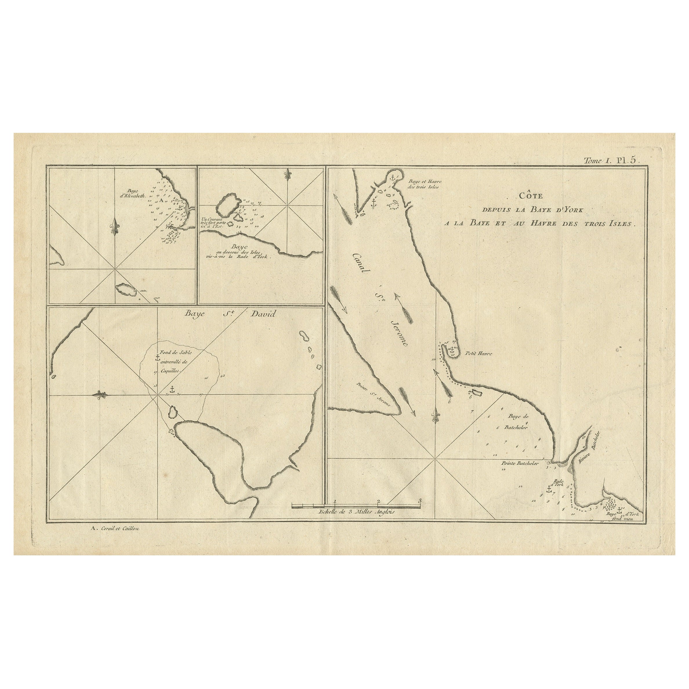
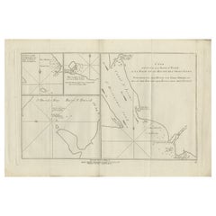
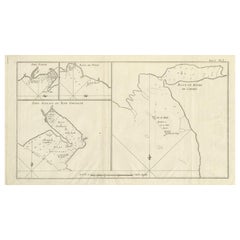
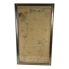
Antique Print with Charts of York's Bay and Surroundings
About the Item
Antique map titled 'Côte depuis la Baye d'York (..)'. Charts of York's Bay, Haven of the Three Islands, St. David's Bay, and Elizabeth's Bay.
Published in an edition of John Hawkesworth's atlas to accompany a French edition of Captain James Cook's voyages to the Southern Hemisphere. Published 1774.
- Dimensions:Height: 10.75 in (27.3 cm)Width: 15.36 in (39 cm)Depth: 0.02 in (0.5 mm)
- Materials and Techniques:
- Period:
- Date of Manufacture:1774
- Condition:General age-related toning. Shows some wear and soiling, few small spots. Blank verso. Please study image carefully.
- Seller Location:Langweer, NL
- Reference Number:
About the Seller
5.0
Platinum Seller
These expertly vetted sellers are 1stDibs' most experienced sellers and are rated highest by our customers.
Established in 2009
1stDibs seller since 2017
1,940 sales on 1stDibs
Typical response time: <1 hour
- ShippingRetrieving quote...Ships From: Langweer, Netherlands
- Return PolicyA return for this item may be initiated within 14 days of delivery.
More From This SellerView All
- Antique Chart of York's Bay and Surroundings by Hawkesworth, 1774Located in Langweer, NLAntique print titled 'Baye St. David (..)'. Charts of York's Bay, Haven of the Three Islands, St. David's Bay, and Elizabeth's Bay. Originates from 'Geschichte der See-Reisen und Ent...Category
Antique 18th Century Prints
MaterialsPaper
- Antique Map of York's Bay, Haven of the Three Islands and SurroundingsLocated in Langweer, NLAntique map titled 'Baye St. David (..)'. Charts of York's Bay, Haven of the Three Islands, St. David's Bay, and Elizabeth's Bay. This map originates from the French edition of 'An A...Category
Antique Late 18th Century Maps
MaterialsPaper
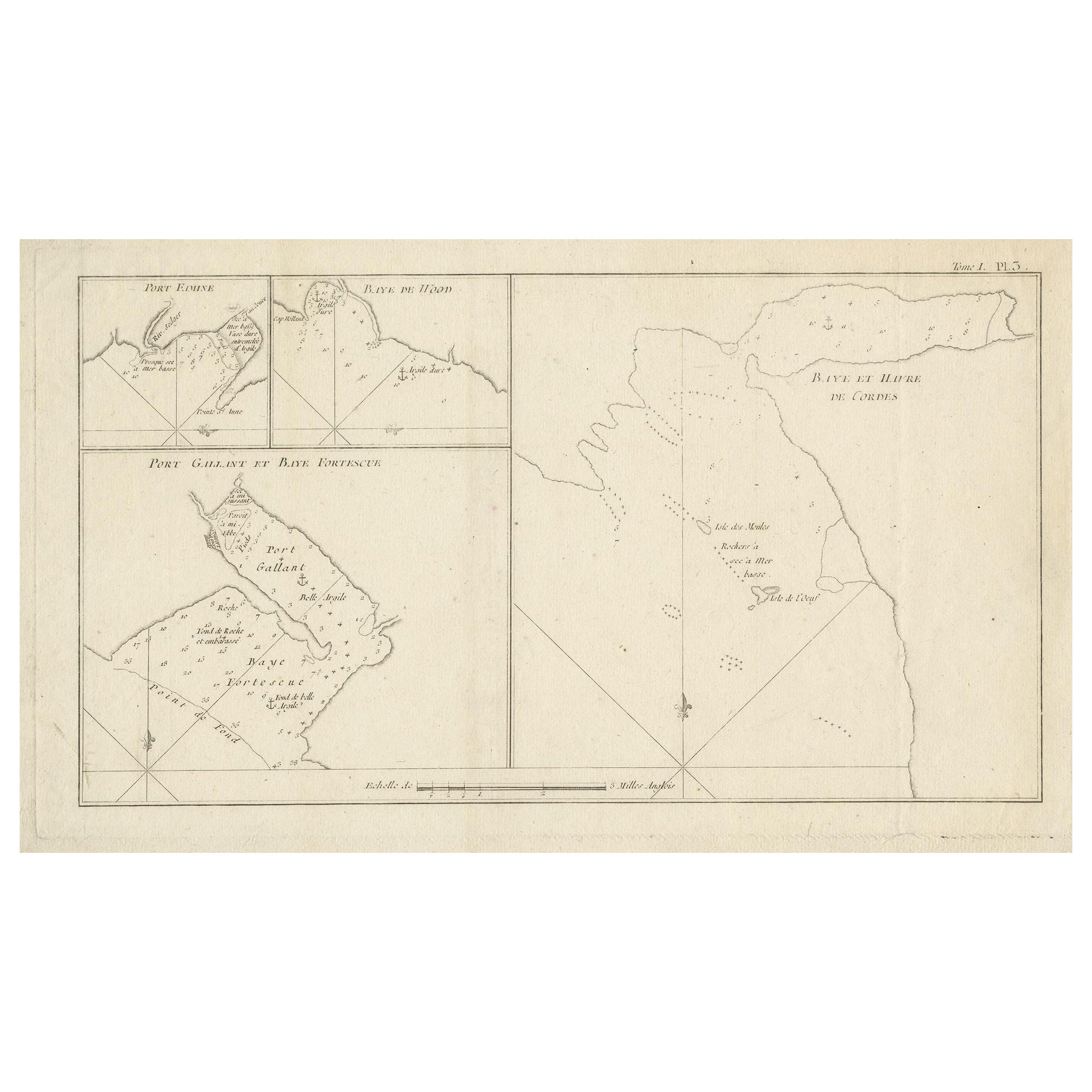
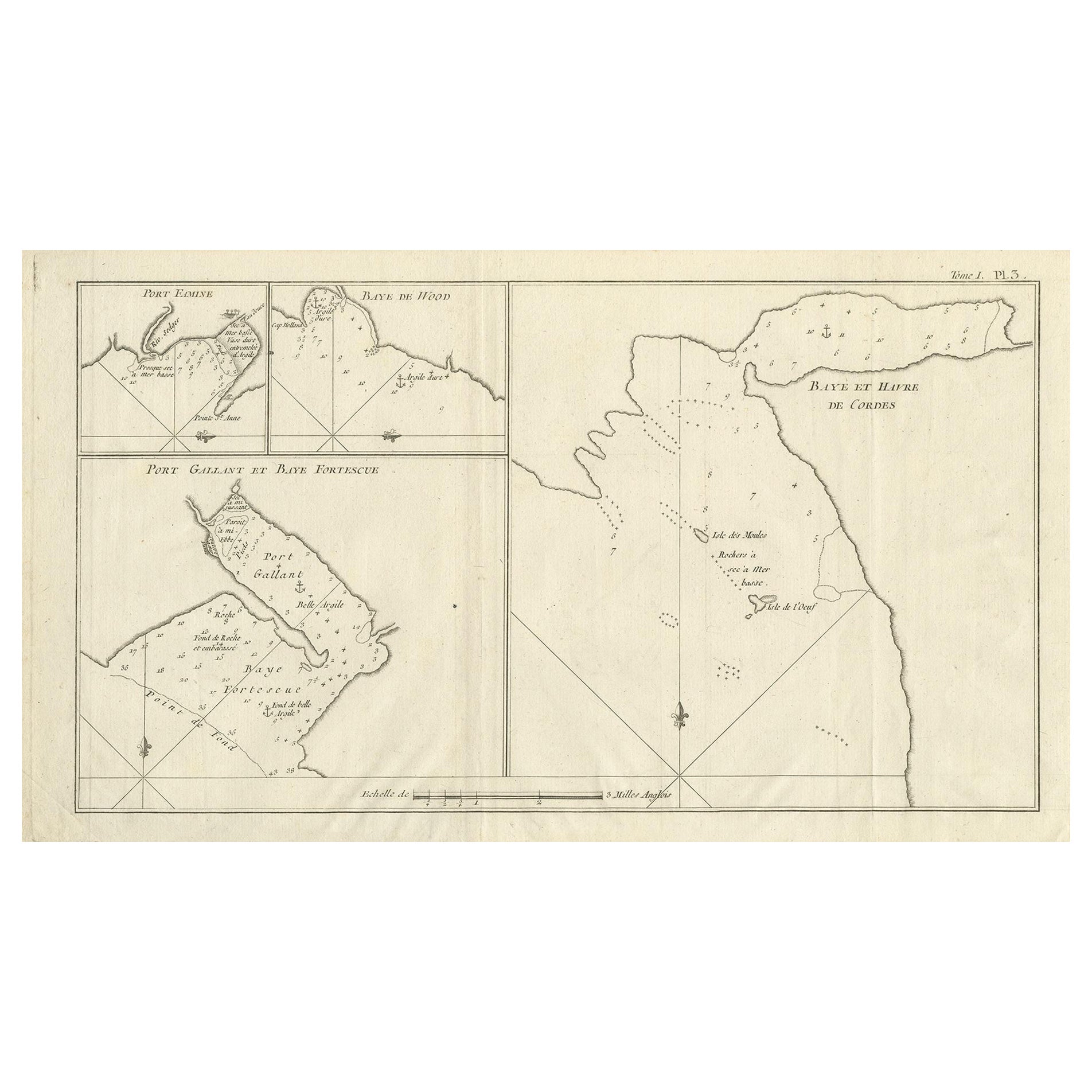
- Antique Map of Cordes Bay and SurroundingsLocated in Langweer, NLAntique map titled 'Baye et Havre de Cordes (..)'. Four maps on the one sheet of; Cordes Bay, Port Famine, Woods Pay, Port Gallant, Fortescue Bay, Chile based on the voyage of John B...Category
Antique Late 18th Century Maps
MaterialsPaper
- Antique Map of Cordes Bay, Port Famine, Woods Bay and SurroundingsLocated in Langweer, NLAntique map titled 'Baye et Havre de Cordes (..)'. Four maps on the one sheet of; Cordes Bay, Port Famine, Woods Bay, Port Gallant, Fortescue Bay, Chile based on the voyage of John B...Category
Antique Late 18th Century Maps
MaterialsPaper
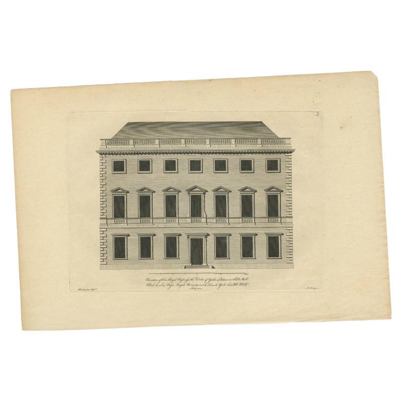
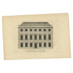
- Antique Print of the Duke of York's Palace by Woolfe, c.1770Located in Langweer, NLAntique print titled 'Elevation of his Royal Highness the Duke of York's Palace in Pall Mall (..)'. View of the Duke of York's Palace in Pall Mall, London. This print originates from...Category
Antique 18th Century Prints
MaterialsPaper
- Antique Map of the Bay of Cordes and Surroundings by Hawkesworth, 1774Located in Langweer, NLAntique print titled 'Baye et Havre de Cordes (..)'. Four maps on the one sheet of; Cordes Bay, Port Famine, Woods Pay, Port Gallant, Fortescue Bay, Chile based on the voyage of John...Category
Antique 18th Century Maps
MaterialsPaper
You May Also Like
- 1898 Chart of Boston BayLocated in Norwell, MAOriginal 1898 chart showing Massachusetts Bay with the coast from Cape Ann to Cape Cod. This is a U.S. Navy Geodetic survey chart. All towns are noted along the coast. Framed with gl...Category
Antique 1890s Nautical Objects
MaterialsPaper
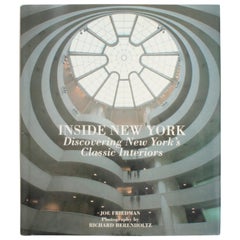
- Inside New York, Discovering New York's Classic Interiors, First EditionLocated in valatie, NYInside New York, Discovering New York's Classic interiors by Joe Friedman. New York: Harper Collins Publishers, 1992. Stated first US edition hardcover with dust jacket. 128 pp. An o...Category
20th Century American Books
MaterialsPaper
- 1918 George Eldridge Chart of Massachusetts BayLocated in Norwell, MARare early twentieth century chart of Cape Cod bay by George Eldridge showing Massachusetts Bay, and the coast from Chatham to Gloucester 1918. Signed George Eldridge. This great ch...Category
Vintage 1910s North American Maps
MaterialsPaper
- Antique Zoological Wall ChartLocated in Oakville, CTAntique Pfurtscheller wall chart Overall Dimensions: 53" x 56" Chart Dimensions: 50 1/2" x 56 Materials: Paper & Linen.Category
Antique Late 19th Century Austrian Posters
MaterialsLinen, Paper
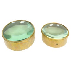
- Antique Nautical Chart Brass MagnifiersLocated in New York, NYEach with domed glass set within a brass surround. Of large size. Dimensions: One: Height: 4 x Diameter: 8.5 inchesThe Other: Height: 4.5 x Diameter: 11 inchesCategory
Early 20th Century Nautical Objects
MaterialsBrass
- 1856 U.S. Coast Survey Map of Chesapeake Bay and Delaware BayLocated in Colorado Springs, COPresented is U.S. Coast Survey nautical chart or maritime map of Chesapeake Bay and Delaware Bay from 1856. The map depicts the region from Susquehanna, Maryland to the northern Outer Banks in North Carolina. It also shows from Richmond and Petersburg, Virginia to the Atlantic Ocean. The map is highly detailed with many cities and towns labeled throughout. Rivers, inlets, and bays are also labeled. Various charts illustrating more specific parts of the region are marked on the map using dotted lines. The lines form boxes, and the corresponding chart number and publication date are given. Extensive triangulation surveys were conducted the length of Chesapeake Bay and are illustrated here. Hampton Roads, Virginia is labeled, along with the James, York, and Rappahannock Rivers, which were all extensively surveyed. The chart was published under the supervision of A. D. Bache, one of the most influential and prolific figures in the early history of the U.S. Coast Survey, for the 1856 Report of the Superintendent of the U.S. Coast Survey. Alexander Dallas Bache (1806-1867) was an American physicist, scientist, and surveyor. Bache served as the Superintendent of the U.S. Coast Survey from 1843 to 1865. Born in Philadelphia, Bache toured Europe and composed an important treatise on European Education. He also served as president of Philadelphia's Central High School and was a professor of natural history and chemistry at the University of Pennsylvania. Upon the death of Ferdinand Rudolph Hassler, Bache was appointed Superintendent of the United States Coast Survey. The Office of the Coast Survey, founded in 1807 by President Thomas Jefferson and Secretary of Commerce Albert Gallatin...Category
Antique 1850s American Maps
MaterialsPaper


Recently Viewed
View AllMore Ways To Browse
Sierra Leone Antique Map
Antique Colorado Map
Antique Maps Colorado
Vietnam Map
Antique Map Of Colorado
Congo Antique Map
World Map Relief
Antique Map Norfolk
Antique Maps Norfolk
Brooklyn Map
Gambia Antique Map
Vintage Bartholomew Maps
Vintage Bartholomews Maps
Antique Brooklyn Map
Antique South Carolina Map
Durham Antique Map
Map Made Of Silver Gold
Mozambique Antique Map