Items Similar to Decorative View of the Indonesian Town of Bantam 'Banten', Java, 1726

Want more images or videos?
Request additional images or videos from the seller
1 of 5
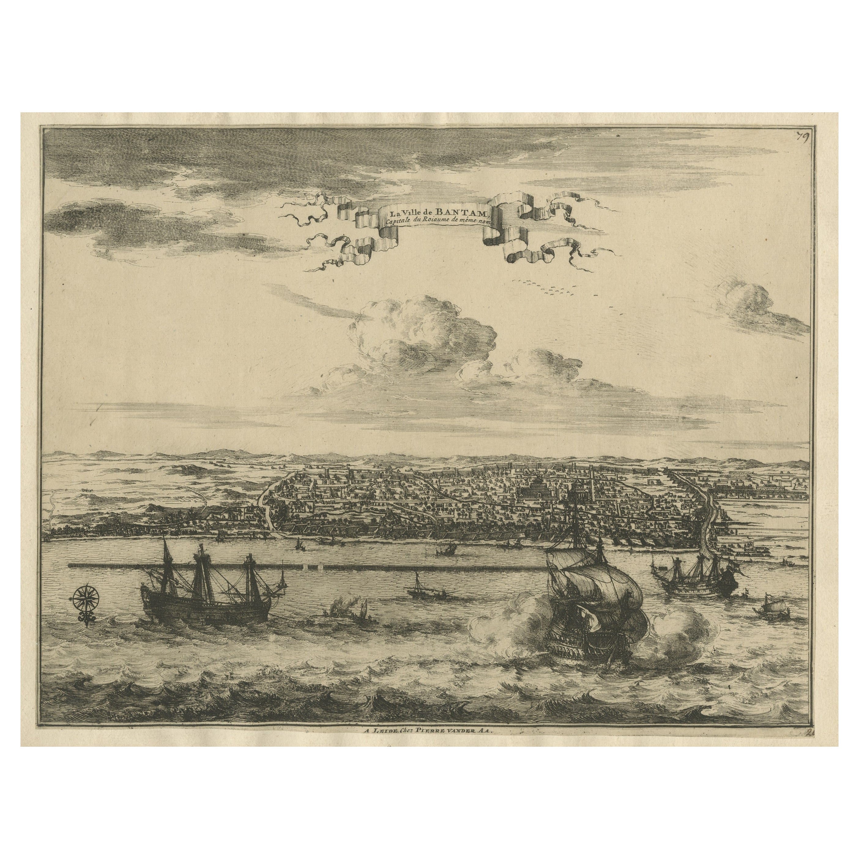
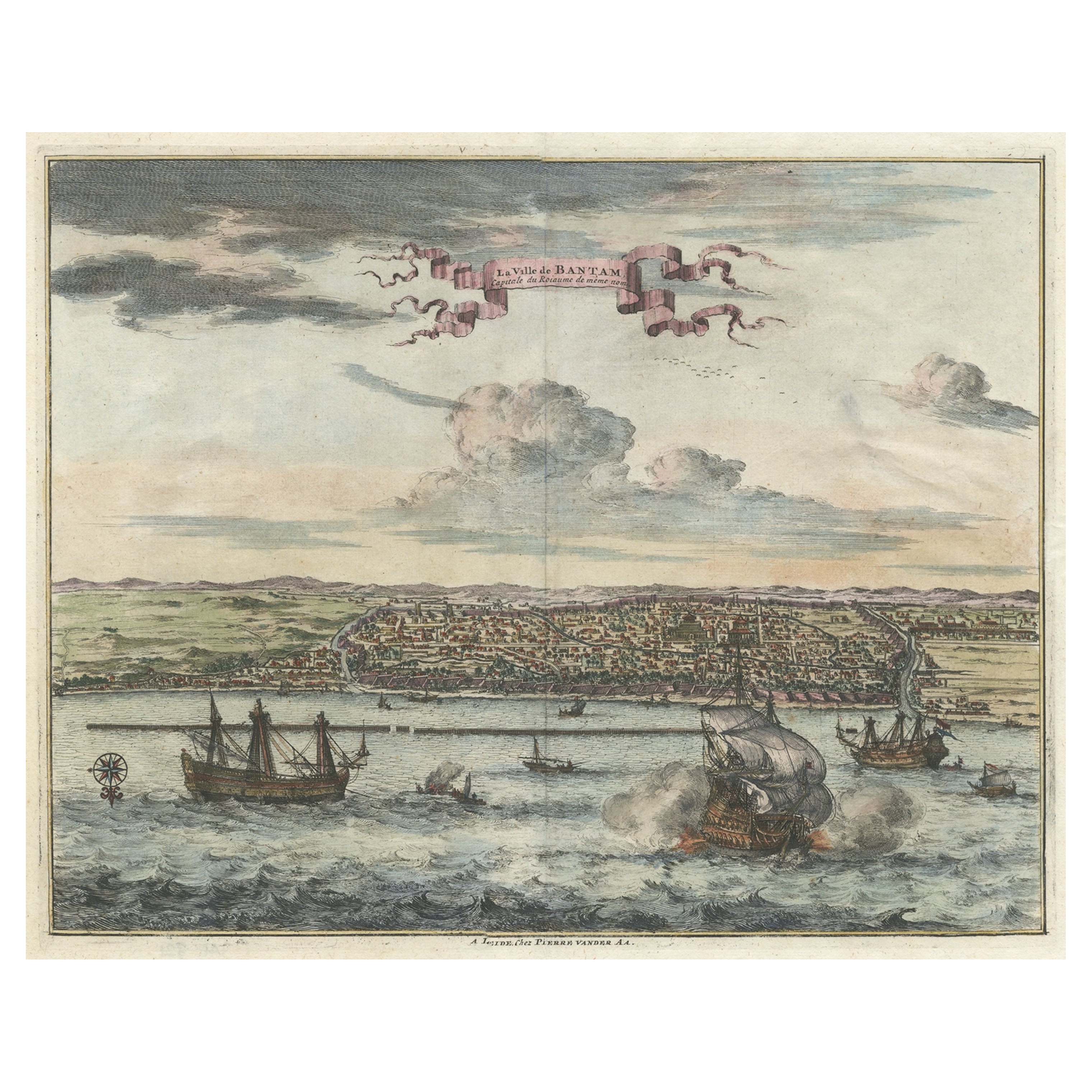
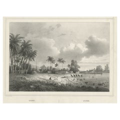
Decorative View of the Indonesian Town of Bantam 'Banten', Java, 1726
About the Item
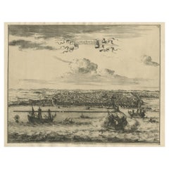
Decorative town-view of the town of Bantam (Banten). In lower margin key a-z to the principal places in town.
The Banten Sultanate was founded in the 16th century and centred in Banten, a port city on the northwest coast of Java; the contemporary English spelling of both was Bantam. It is said to have been founded by Sunan Gunungjati, who had previously founded Cirebon.
Artists and Engravers: Francois Valentijn (1666-1727), a missionary, worked at Amboina from 1684 to 1694 and 1705 to 1713 and travelled extensively in the territory of the Dutch V.O.C. He is best known for his monumental history and description, ''Oud en Nieuw Oost-Indiën'' which remains one of the most important primary sources for the East Indies and neighboring lands.
- Dimensions:Height: 12.8 in (32.5 cm)Width: 16.74 in (42.5 cm)Depth: 0 in (0.02 mm)
- Materials and Techniques:
- Period:1720-1729
- Date of Manufacture:1726
- Condition:Wear consistent with age and use. Condition: Very good, given age. Original folds, as issued. Please study scan carefully.
- Seller Location:Langweer, NL
- Reference Number:
About the Seller
5.0
Platinum Seller
These expertly vetted sellers are 1stDibs' most experienced sellers and are rated highest by our customers.
Established in 2009
1stDibs seller since 2017
1,933 sales on 1stDibs
Typical response time: <1 hour
- ShippingRetrieving quote...Ships From: Langweer, Netherlands
- Return PolicyA return for this item may be initiated within 14 days of delivery.
More From This SellerView All
- Antique Print of Bantam or Banten, Java, Indonesia, '1726'Located in Langweer, NLAntique print titled 'De Stad Bantam'. Decorative town-view of the town of Bantam (Banten). In lower margin key a-z to the principal places in town. The Banten Sultanate was founded ...Category
Antique Mid-18th Century Prints
MaterialsPaper
- View of the City Banten or Bantam Near the Western End of Java, Indonesia, c1725Located in Langweer, NLAntique print titled 'La Ville de Bantam capitale du Roiaume de meme nom'. A bird's eye view of the city Banten or Bantam near the western end of Java in Indonesia. Several tall ...Category
Antique 1720s Maps
MaterialsPaper
- Original Antique Bird's Eye View of Banten or Bantam in Java, Indonesia, 1725Located in Langweer, NLAntique print titled 'La Ville de Bantam capitale du Roiaume de meme nom'. A bird's eye view of the city Banten or Bantam near the western end of Java in Indonesia. Several tall ...Category
Antique 1720s Prints
MaterialsPaper
- Antique Map of Banten Bay, Java, Indonesia, c.1725Located in Langweer, NLA small early 18th century map of Banten Bay showing the islands of Pulo Dua and Pulo Batto together with soundings within the Bay and profiles of hills on the islands published by C...Category
Antique 18th Century Maps
MaterialsPaper
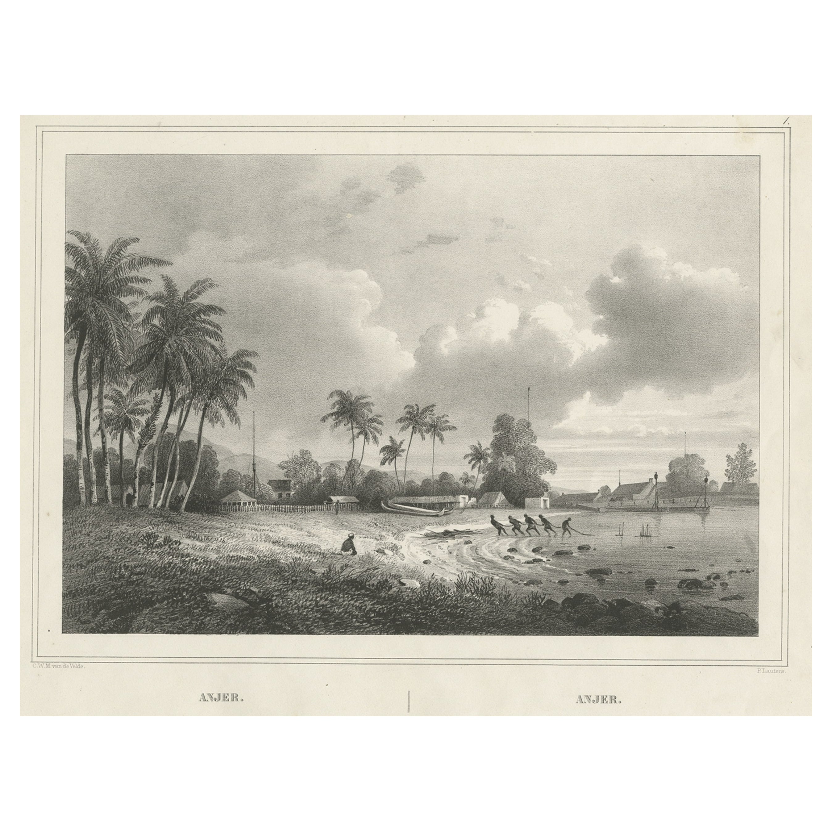
- Old Print of Anjer or Anyer, Coastal Town in Banten, West Java, Indonesia, 1844Located in Langweer, NLAntique print titled 'Anjer - Anjer'. View of Anyer (also known as Anjer or Angier), a coastal town in Banten, formerly West Java, Indonesia. This print originates from 'Gezigten uit...Category
Antique 1840s Prints
MaterialsPaper
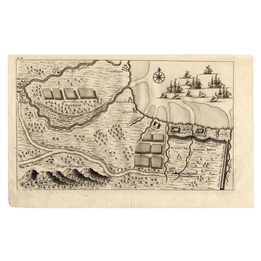
- Antique Map of the Region of Pasuruan, Java, Indonesia, 1726Located in Langweer, NL"Map of the region around Pasuruan. It shows the location of rice fields, the village Bangil, as well as three places named Pagger (also Pagar), a cluster of buildings surrounded by a bamboo fence. The location of a earthen wall with pallisade and small cannons...Category
Antique 18th Century Maps
MaterialsPaper


You May Also Like
- More Massachusetts Towns, Illustrated with Wood Engravings of 53 Mass. TownsLocated in valatie, NYMore Massachusetts Towns, illustrated with wood engravings of fifty-three Massachusetts Towns, drawn in 1840 by J. W. Barber. Commentary by Ivan Sandrof, and a special foreword by Mr...Category
Vintage 1960s American Books
MaterialsPaper
- Vintage "View of the Center of Paris Taken from the Air" Lithograph MapLocated in San Diego, CAA very stylish "View of the Center of Paris Taken from the Air" lithograph map published by the Paris Ministry of Tourism, circa early 1950s. The piece measures 27" x 43" and shows...Category
20th Century French Mid-Century Modern Prints
MaterialsPaper
- N.E. View of the United States Capitol, Washington, DC Antique Proof Print 1858Located in Colorado Springs, COThis engraved print shows a view of the United States Capitol Building, in Washington, D.C. The print depicts the neoclassical building from the northeast orientation, with a bustling street scene in front. The steel engraving is a proof printing, drawn and engraved by Henry Sartain and published in 1858. Plans began in May 1854 to build a new cast-iron dome for the United States Capitol. The then-architect of the Capitol Thomas Walter and his team were sold on the aesthetics of a new dome, as well as the utility of a fire-proof one. A year later, on March 3, 1855, President Franklin Pierce...Category
Antique 1850s American Prints
MaterialsPaper
- Catalogue of Engraved Views, Plans, Etc., Of New York City, 1st EdLocated in valatie, NYA catalogue of engraved views, plans, etc., Of New York City, (The Collection of Percy R. Pyne II). Privately Printed by The De Vinne Press, New York, 1912. Limited to 100 copies. Gr...Category
Early 20th Century American Books
MaterialsPaper
- City View of Nuremberg, Germany: An 18th Century Hand-Colored Map by M. SeutterBy Matthew SeutterLocated in Alamo, CAAn 18th century hand-colored city view of Nuremburg, Germany entitled "Geometrischer Grundris der des Heiligen Römischen Reichs Freyen Stadt Nürnberg" by Matthaus Seutter from his "A...Category
Antique Mid-18th Century German Maps
MaterialsPaper
- Map of the Republic of GenoaLocated in New York, NYFramed antique hand-coloured map of the Republic of Genoa including the duchies of Mantua, Modena, and Parma. Europe, late 18th century. Dimension: 25...Category
Antique Late 18th Century European Maps