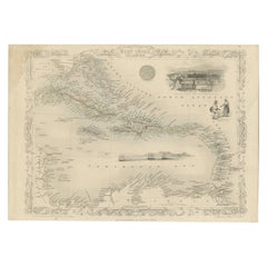
Engraving by Tallis and Rapkin of Map of the West Indies in The Caribbean, 1851
View Similar Items


Want more images or videos?
Request additional images or videos from the seller
1 of 6
Engraving by Tallis and Rapkin of Map of the West Indies in The Caribbean, 1851
About the Item
- Dimensions:Height: 10.44 in (26.5 cm)Width: 14.57 in (37 cm)Depth: 0 in (0.02 mm)
- Materials and Techniques:
- Period:
- Date of Manufacture:1851
- Condition:Good; suitable for framing. Borders colored by hand. Some light spotting in top left corner. Most antiquarian maps and prints are subject to some normal aging due to use and time which is not obtrusive unless otherwise stated.
- Seller Location:Langweer, NL
- Reference Number:Seller: BG-13619-51stDibs: LU3054337491542
About the Seller
5.0
Recognized Seller
These prestigious sellers are industry leaders and represent the highest echelon for item quality and design.
Gold Seller
Premium sellers maintaining a 4.3+ rating and 24-hour response times
Established in 2009
1stDibs seller since 2017
2,464 sales on 1stDibs
Typical response time: 1 hour
Authenticity Guarantee
In the unlikely event there’s an issue with an item’s authenticity, contact us within 1 year for a full refund. DetailsMoney-Back Guarantee
If your item is not as described, is damaged in transit, or does not arrive, contact us within 7 days for a full refund. Details24-Hour Cancellation
You have a 24-hour grace period in which to reconsider your purchase, with no questions asked.Vetted Professional Sellers
Our world-class sellers must adhere to strict standards for service and quality, maintaining the integrity of our listings.Price-Match Guarantee
If you find that a seller listed the same item for a lower price elsewhere, we’ll match it.Trusted Global Delivery
Our best-in-class carrier network provides specialized shipping options worldwide, including custom delivery.More From This Seller
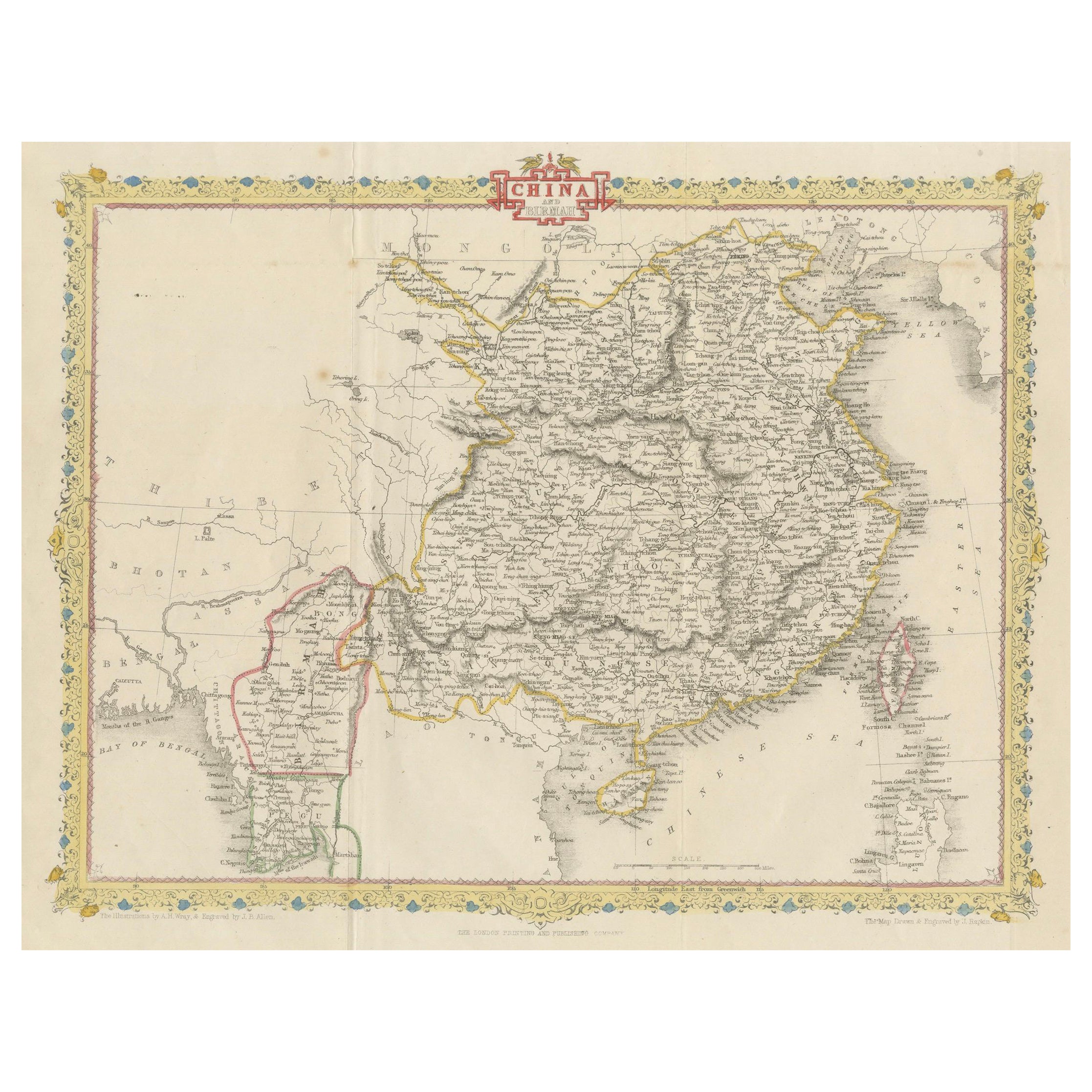
View All1851 Tallis Map of China with Tibet, Formosa, and Burma – Engraved by J. Rapkin
Located in Langweer, NL
Title: 1851 Tallis Map of China with Tibet, Formosa, and Burma – Engraved by J. Rapkin
Description: This is a finely engraved and delicately hand-colored map of China, published a...
Category
Antique 1850s Maps
Materials
Paper
$316 Sale Price
20% Off
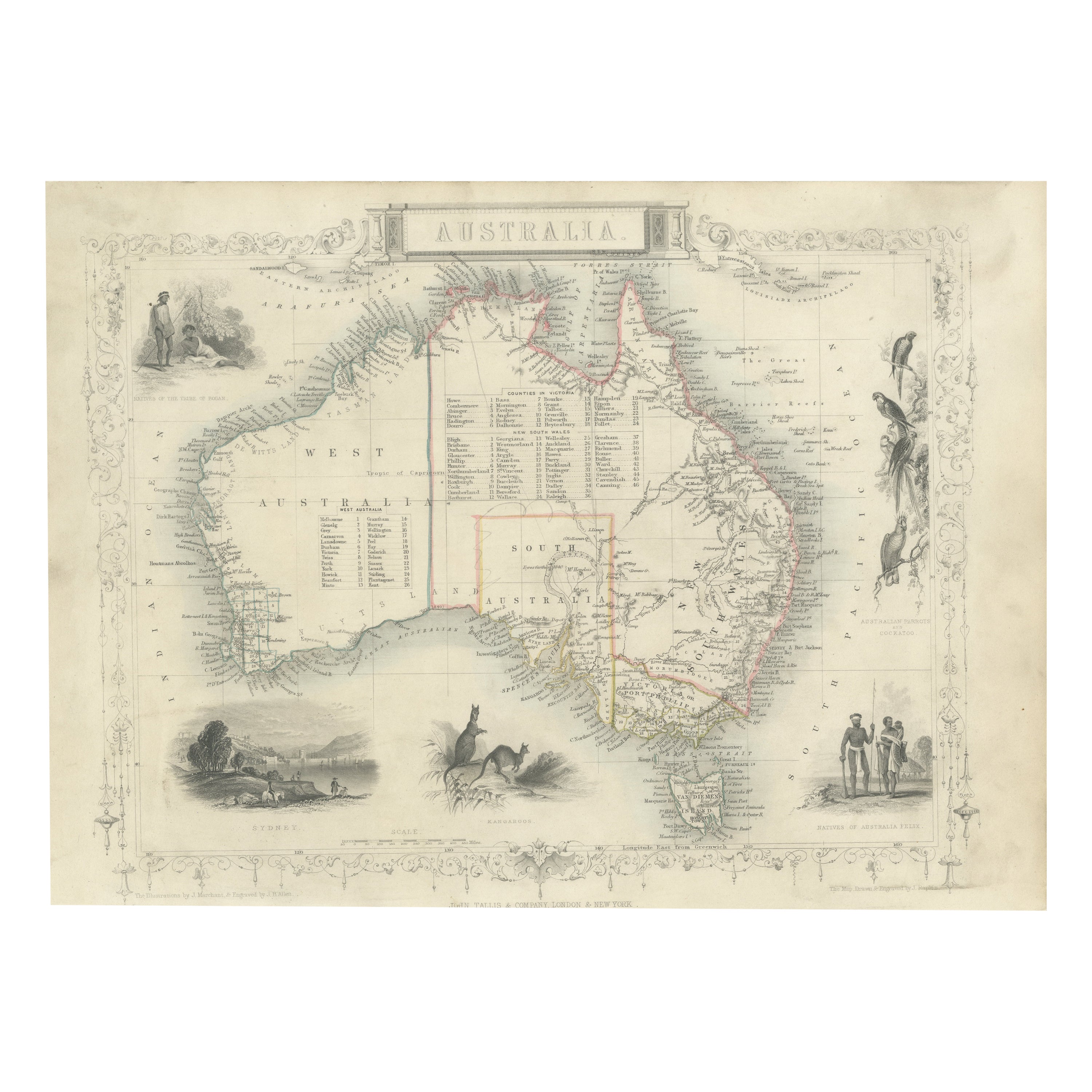
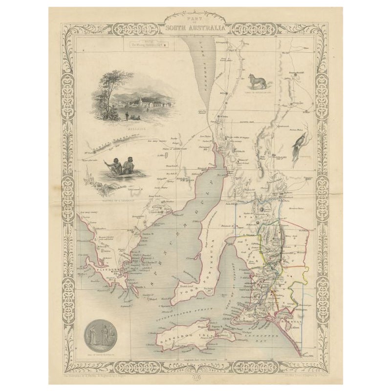
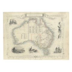
Gold Rush Era Masterpiece: The Tallis & Rapkin Rare Map of Pre-Queensland, 1851
Located in Langweer, NL
The image is an original historical map of Australia from the year 1851, created by John Rapkin with illustrations by J. Marchant and engravings by J. B. Allen. The map was published...
Category
Antique 1850s Maps
Materials
Paper
$539 Sale Price
20% Off
Free Shipping
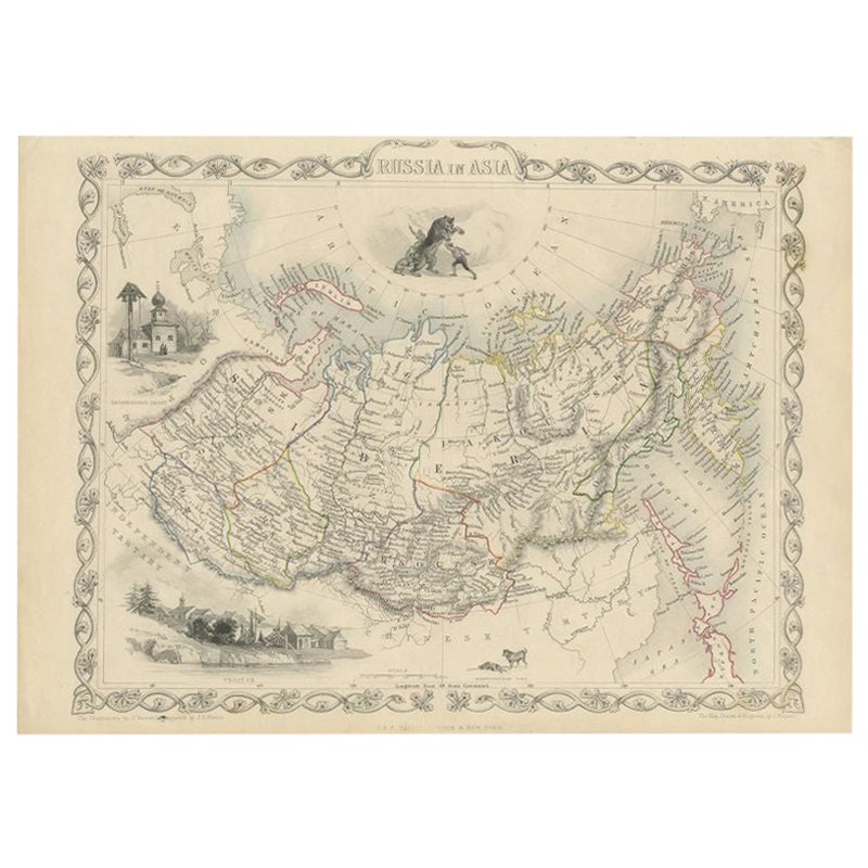
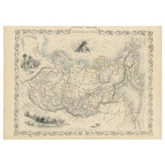
Antique Map of Russia in Asia by Tallis, c.1851
Located in Langweer, NL
Antique map titled 'Russia in Asia'. Map of Russia in Asia. Showing vignettes of a polar hunting scene, Skorskarskoi Pagost, Troitsk and Kamchatkan Dogs. Originates from 'The Illustrated Atlas, And Modern History Of The World Geographical, Political, Commercial & Statistical, Edited By R. Montgomery Martin'. Published; John Tallis London, New York, Edinburgh & Dublin. 1851. Drawn and Engraved by J. Rapkin. Artists and Engravers: John Tallis (1817-1876) was a British map...
Category
Antique 19th Century Maps
Materials
Paper
Antique Map of Russia in Europe by Tallis, '1851'
Located in Langweer, NL
Antique map titled 'Russia in Europe'. Map of European Russia. Showing vignettes of the Neoskoi Prospect, St. Petersburg, Polish Captives on their way to Siberia, a Russian Bear...
Category
Antique Mid-19th Century Maps
Materials
Paper

$232 Sale Price
20% Off
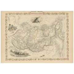
Antique Map of Russia in Asia by Tallis, '1851'
Located in Langweer, NL
Antique map titled 'Russia in Asia'. Map of Russia in Asia. Showing vignettes of a polar hunting scene, Skorskarskoi Pagost, Troitsk and Kamchatkan Dogs. Originates from 'The Illustr...
Category
Antique Mid-19th Century Maps
Materials
Paper
$255 Sale Price
20% Off
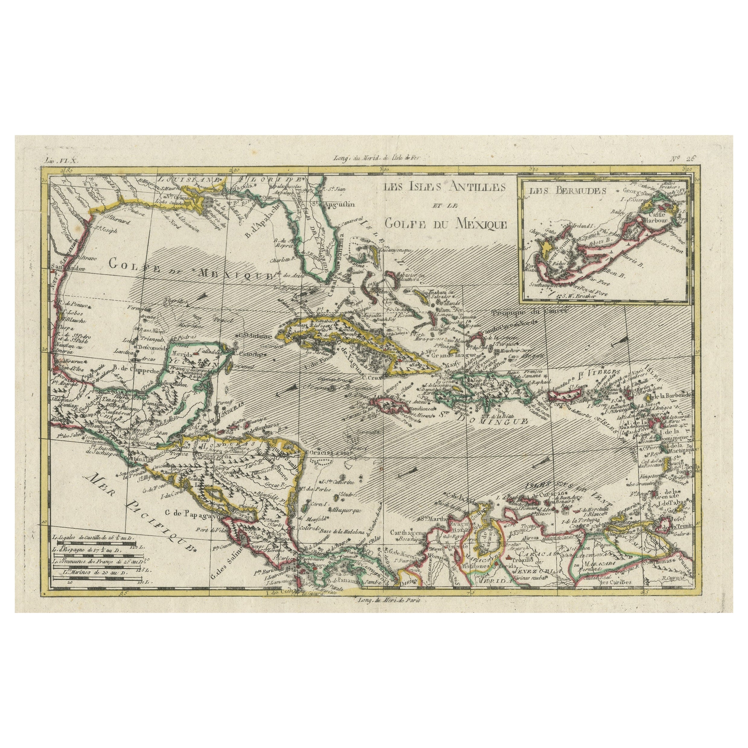
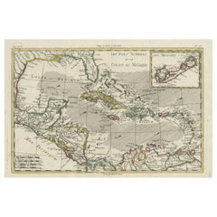
Original Engraving of the West Indies, Gulf of Mexico, Antilles, Caribbean, 1780
Located in Langweer, NL
Rigobert Bonne and G. Raynal's 1780 map of the West Indies, Gulf of Mexico, Antilles, and the Caribbean stands as a remarkable cartographic piece, offering a detailed and expansive v...
Category
Antique Late 18th Century Maps
Materials
Paper
$362 Sale Price
20% Off
You May Also Like
Large Original Antique Map of The West Indies by Sidney Hall, 1847
Located in St Annes, Lancashire
Great map of The West Indies
Drawn and engraved by Sidney Hall
Steel engraving
Original colour outline
Published by A & C Black. 1847
Unframed
Free shipping.
Category
Antique 1840s Scottish Maps
Materials
Paper

Seminal guide to the East and West Indies, with 42 coloured maps and plates
By Jan Huygen van Linschoten
Located in ZWIJNDRECHT, NL
Seminal guide to the East and West Indies, with 42 double-page and folding plates, including 6 maps, all engravings beautifully coloured by a contemporary hand
LINSCHOTEN, Jan Huygh...
Category
Antique Early 17th Century Dutch Dutch Colonial Books
Materials
Paper

$261,709 Sale Price
25% Off
Free Shipping
Cricket Print, England v. West Indies at the Oval, by Arthur Weaver
By Arthur Weaver
Located in Oxfordshire, GB
1990's Arthur Weaver Oval Cricket Ground Print, England v West Indies.
A colourful cricket lithograph signed by the artist, Arthur Weaver, of the 'Final Test' at The Oval Cricket Gr...
Category
1990s English Sporting Art Sports Equipment and Memorabilia
Materials
Paper

1851 Map of "Independent Tartary", Ric. R018
Located in Norton, MA
1851 Map of
Independent Tartary
"Russia"
Ric.r018
A highly decorative 1851 map of Independent Tartary by John Tallis and John Rapkin. Covers the regions between the Caspian Sea and Lake Bakquash and between Russia and Afghanistan. These include the ancient Silk Route kingdoms of Khiva, Tartaria, Kokand, and Bokhara. Today this region roughly includes Kazakhstan, Uzbekistan, Turkmenistan, Kyrgyzstan, and Tajikistan. This wonderful map offers a wealth of detail for anyone with an interest in the Central Asian portion of the ancient Silk Road. Identifies various caravan routes, deserts, wells, and stopping points, including the cities of Bokhara and Samarkand. Three vignettes by W. Bragg decorate the map, these including an image of Tartars on a Journey, a horseback Bride Chase, and a tartar camp site. Surrounded by a vine motif border. Engraved by J. Rapkin for John Tallis's 1851 Illustrated Atlas .
Tartary Antique Map...
Category
Antique 19th Century Unknown Maps
Materials
Paper

Early 19th Century Hand Colored Map of the United States and Caribbean Islands
Located in Hamilton, Ontario
Hand coloured early 19th century map by Giraldon of France titled "Etats Unis et Grandes Antilles" (United States and Greater Antilles).
Category
Antique Early 19th Century French Maps
Materials
Paper

$595 Sale Price
40% Off
"San Francisco, Upper California” 1851 Antique Map of San Francisco
Located in Colorado Springs, CO
This is a pictorial lettersheet view of the city and harbor of San Francisco. This lithograph was printed on grey wove paper, across a double sheet, by famed lithographers Britton & ...
Category
Antique 1850s American Prints
Materials
Paper

$1,200 Sale Price
20% Off
Recently Viewed
View AllMore Ways To Browse
Virgin Santos
Wheel Barometer
White Deer Mount
White Ironstone Bowl
White Jade Bowl
Wicker Barrel Chair
Wicker Club Chairs Woven
William Gladstone
William Iv Dining Table Rosewood
William Morris Cushion
Windsor Captains Chair
Windsor Chairs Set Of 6
Wmf Brass And Copper
Womb Sofa
Wood Art Collage Brutalist
Wood Carved Bear Bench
Wood Carved Stag Head
Wood Toy Horse On Wheels