Items Similar to The Illustrated Map of the Var Department from the Atlas National Illustré, 1856
Want more images or videos?
Request additional images or videos from the seller
1 of 8
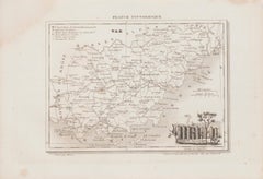
The Illustrated Map of the Var Department from the Atlas National Illustré, 1856
$324.47
$405.5920% Off
£239.89
£299.8620% Off
€272
€34020% Off
CA$446.31
CA$557.8820% Off
A$496.10
A$620.1220% Off
CHF 260.04
CHF 325.0520% Off
MX$6,058.55
MX$7,573.1820% Off
NOK 3,246.49
NOK 4,058.1220% Off
SEK 3,054.34
SEK 3,817.9320% Off
DKK 2,070.73
DKK 2,588.4120% Off
About the Item
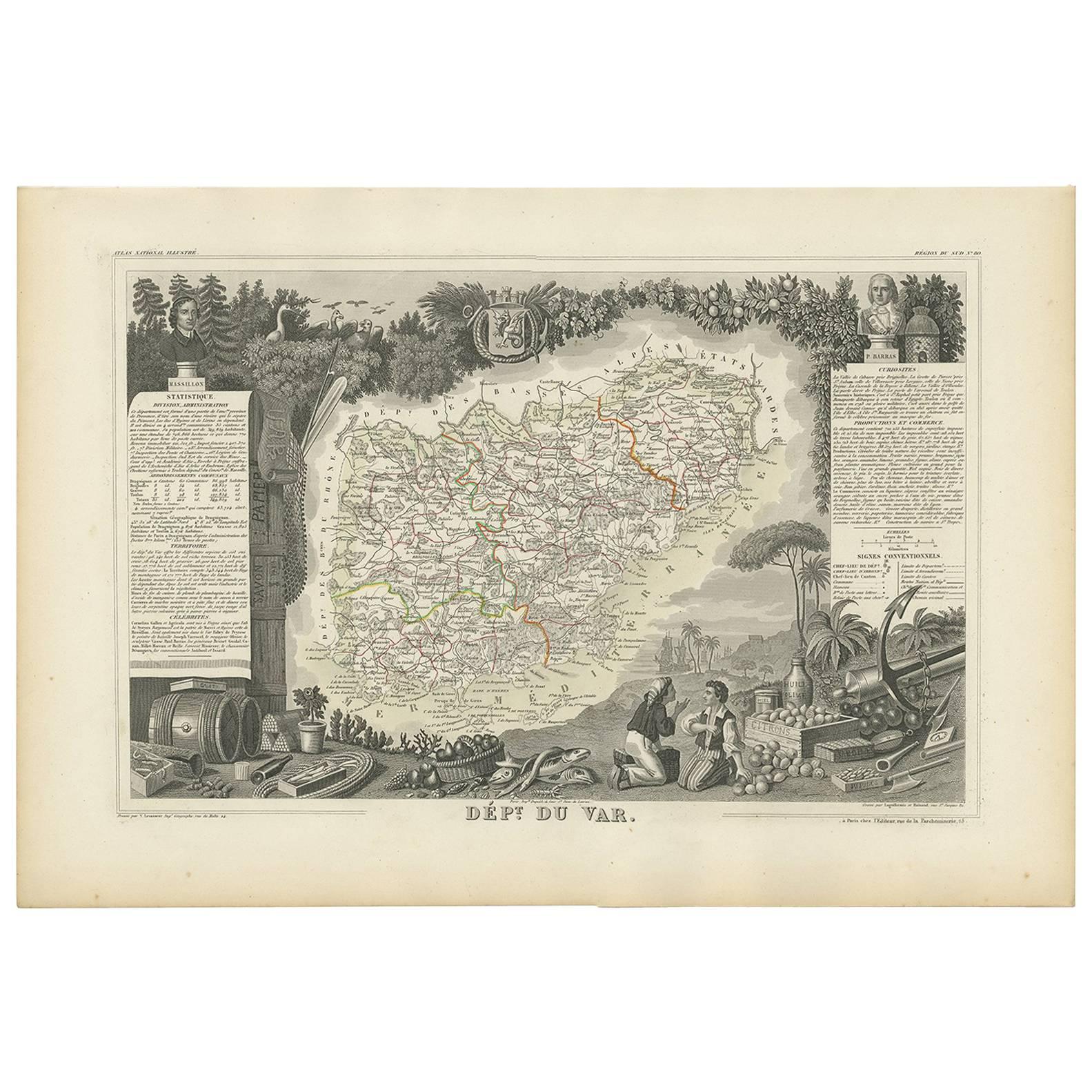
This original hand-colored map is from the "Atlas National Illustré," a work by Victor Levasseur, a French geographer and cartographer known for his richly illustrated maps.
The map of 'Dépt. du Var' from 1856 is a steel engraving, which was a common and precise method for creating maps at the time. The inclusion of the publisher's name, A. Combette from Paris, and the addresses of the various contributors to the map's creation, like the engravers Laguillermie and Rainaud, adds to the historical context of the piece.
The margins of the map are adorned with detailed illustrations that serve as a visual encyclopedic reference to the region's geography, economy, and notable figures. The use of color along the boundaries makes the map not only a tool for navigation but also an educational resource, providing insights into the Var department's landscape, economy, and cultural significance.
The text included in the map's design provides statistical information, a map legend, and discussions about the land, local curiosities, notable personalities, products, and commerce, which would have been invaluable for education and reference at the time.
The 'Atlas National Illustré' is celebrated for its combination of cartographic detail and artistic embellishment, making it a valuable cultural artifact. It represents the height of decorative map-making in the 19th century, alongside the works of John Tallis and Archibald Fullarton.
The map of the 'Département du Var' from the Atlas National Illustré would typically highlight various important towns, cities, and geographical features that make the region famous. While I cannot see the specific details on this map due to resolution constraints, I can provide information on significant places within the Var department that are historically and culturally important:
1. **Toulon**: As the prefecture (capital) of the Var, Toulon is a significant military port on the Mediterranean coast and home to the French Navy's main base.
2. **Saint-Tropez**: This town is renowned worldwide for its beaches and nightlife, historically a fishing village and later a resort for the European and American jet set and a destination for tourists.
3. **Hyères**: Often referred to as Hyères les Palmiers due to the palm trees that characterize its streets, Hyères is known for its medieval core and as a gateway to the beautiful Îles d'Hyères.
4. **Draguignan**: This town was historically the administrative center of the Var and is known for its traditional Provençal culture.
5. **Fréjus**: An ancient town with Roman ruins, Fréjus is also recognized for its beautiful beaches and as a summer resort.
6. **The Massif de l'Esterel**: This mountain range is famous for its red rocks and dramatic landscape, offering numerous hiking trails and stunning views of the Mediterranean.
7. **The Gorges du Verdon**: Often called France's Grand Canyon, it's a river canyon that is considered to be one of Europe's most beautiful. It may or may not be shown on the map, depending on the scope, as it lies on the border of the Var and the Alpes-de-Haute-Provence departments.
8. **The Îles d'Hyères**: Including Porquerolles, Port-Cros, and the Île du Levant, these islands are known for their natural beauty and serve as popular destinations for boating, hiking, and swimming.
9. **The vineyards**: Var is known for its wine production, with vineyards that are part of the Côtes de Provence and Bandol AOCs (Appellations d'Origine Contrôlée).
- Dimensions:Height: 14.18 in (36 cm)Width: 20.87 in (53 cm)Depth: 0 in (0.02 mm)
- Materials and Techniques:
- Period:
- Date of Manufacture:1856
- Condition:Good. The hand-coloring has been done professionally. Some soiling and browning around the edges, not affecting the image. Study the images carefully.
- Seller Location:Langweer, NL
- Reference Number:Seller: BG-13703-31stDibs: LU3054338226472
About the Seller
5.0
Recognized Seller
These prestigious sellers are industry leaders and represent the highest echelon for item quality and design.
Platinum Seller
Premium sellers with a 4.7+ rating and 24-hour response times
Established in 2009
1stDibs seller since 2017
2,604 sales on 1stDibs
Typical response time: <1 hour
- ShippingRetrieving quote...Shipping from: Langweer, Netherlands
- Return Policy
Authenticity Guarantee
In the unlikely event there’s an issue with an item’s authenticity, contact us within 1 year for a full refund. DetailsMoney-Back Guarantee
If your item is not as described, is damaged in transit, or does not arrive, contact us within 7 days for a full refund. Details24-Hour Cancellation
You have a 24-hour grace period in which to reconsider your purchase, with no questions asked.Vetted Professional Sellers
Our world-class sellers must adhere to strict standards for service and quality, maintaining the integrity of our listings.Price-Match Guarantee
If you find that a seller listed the same item for a lower price elsewhere, we’ll match it.Trusted Global Delivery
Our best-in-class carrier network provides specialized shipping options worldwide, including custom delivery.More From This Seller
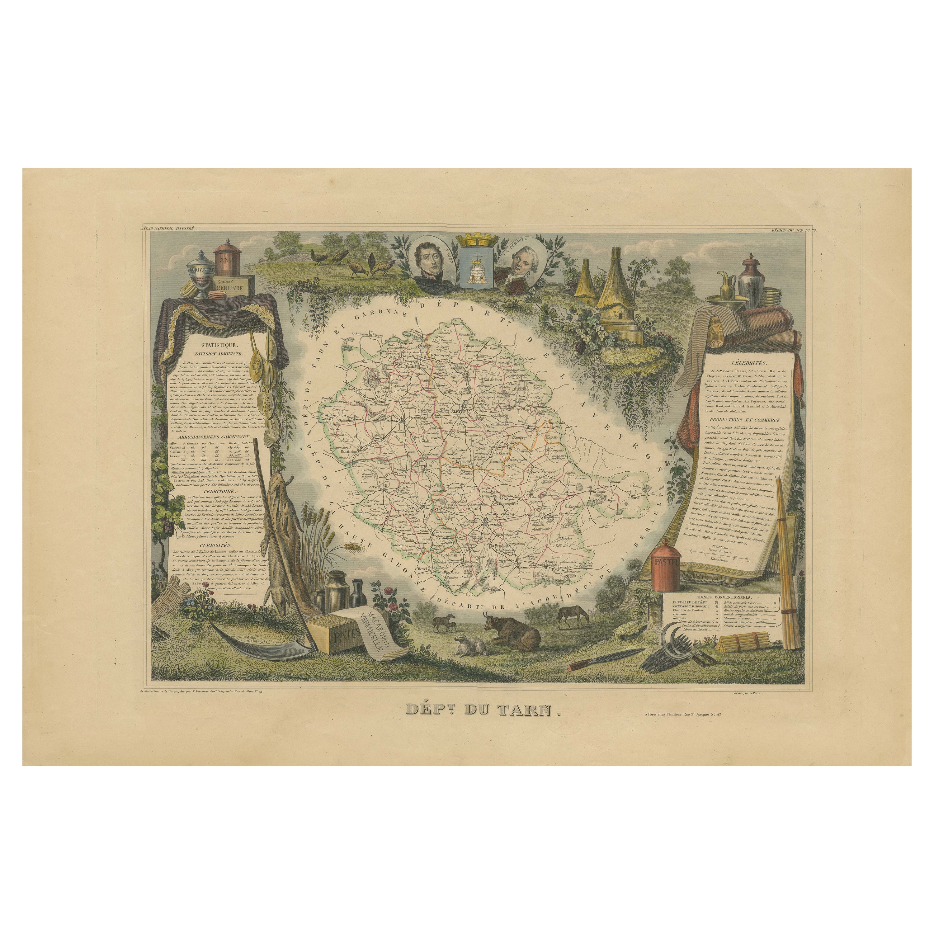
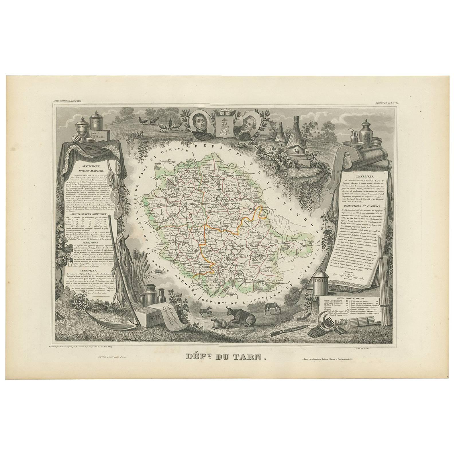
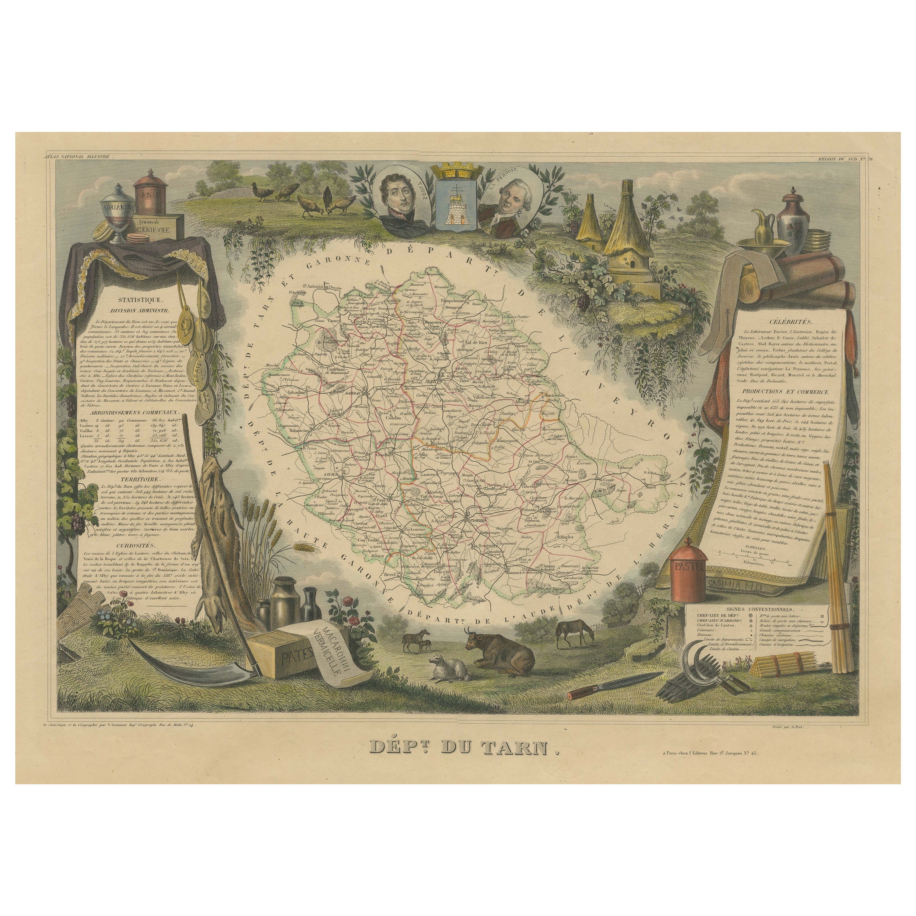
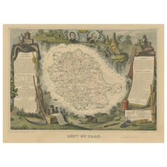
View AllAntique Map of the Department De Tarn, 'France' by v. Levasseur, c. 1852
Located in Langweer, NL
Antique map titled 'Dépt Du Tarn'. Map of the French department of Du tarn, France.
This area produces a variety of traditional wines, including Cahors, Mauzac, Loin de l’Oeil an...
Category
Antique Mid-19th Century French Maps
Materials
Paper

$214 Sale Price
20% Off
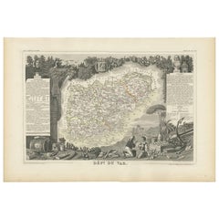
Antique Map of Var 'France' by V. Levasseur, 1854
By Victor Levasseur
Located in Langweer, NL
Antique map titled 'Dépt. du Var'. Map of the French department of Var, the heart of the French Riviera or Côte d'Azur. Includes the resort cities of Cannes, Nice and San Tropez...
Category
Antique Mid-19th Century Maps
Materials
Paper
$171 Sale Price
20% Off
Antique Map of Tarn 'France' by V. Levasseur, 1854
By Victor Levasseur
Located in Langweer, NL
Antique map titled 'Dépt. du Tarn'. Map of the French department of Tarn, France. This area produces a variety of traditional wines, including Cahors, Mauzac, Loin de l'Oeil and Onde...
Category
Antique Mid-19th Century Maps
Materials
Paper

$171 Sale Price
20% Off
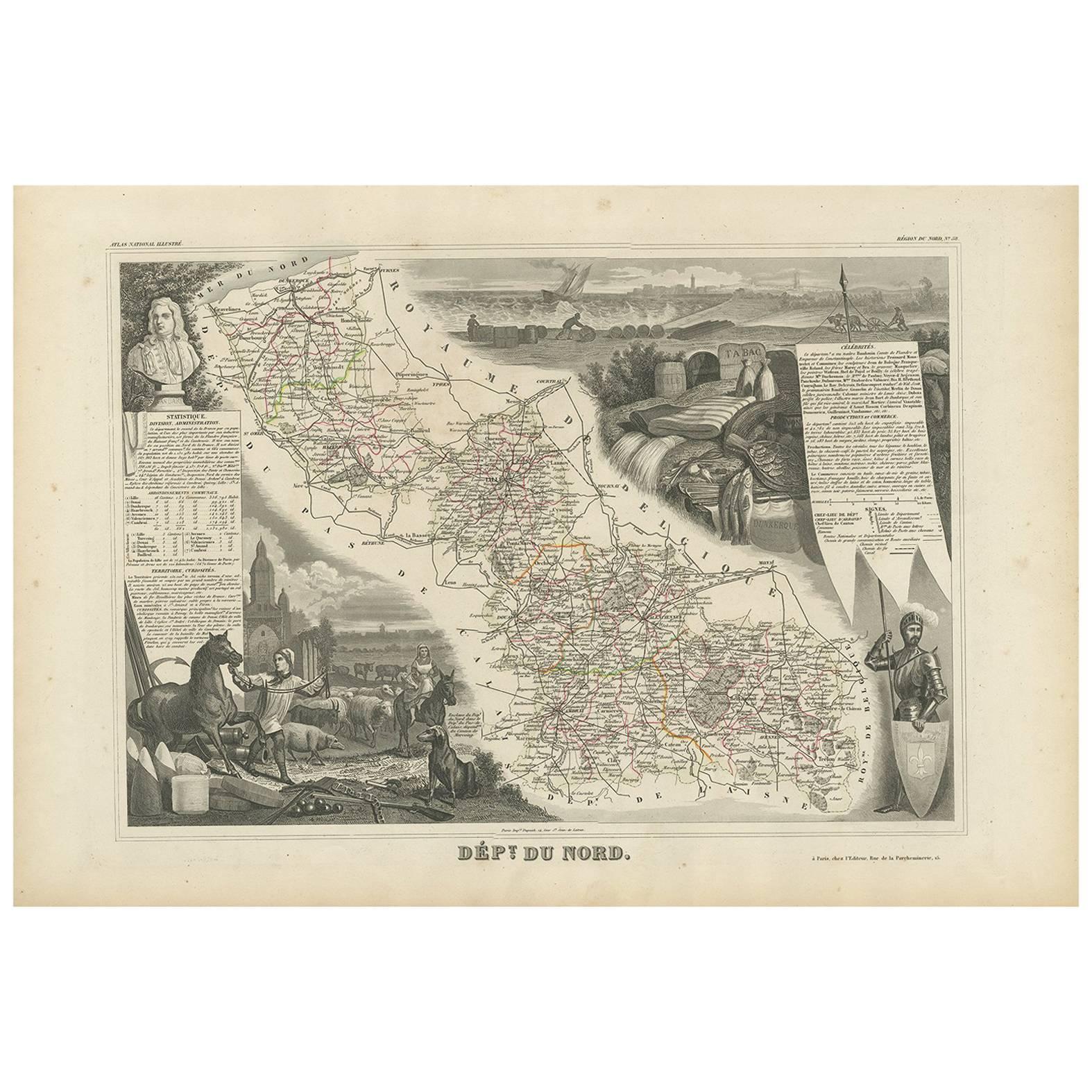
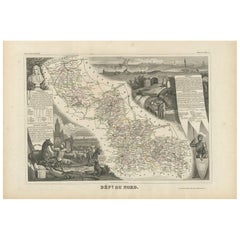
Antique Map of Du Nord ‘France’ by V. Levasseur, 1854
Located in Langweer, NL
Antique map titled 'Dépt. du Nord'. Map of the French department of Nord, France. This area is known for its production of Maroilles, a cow's milk cheese. This cheese is produced in ...
Category
Antique Mid-19th Century Maps
Materials
Paper
$190 Sale Price
20% Off
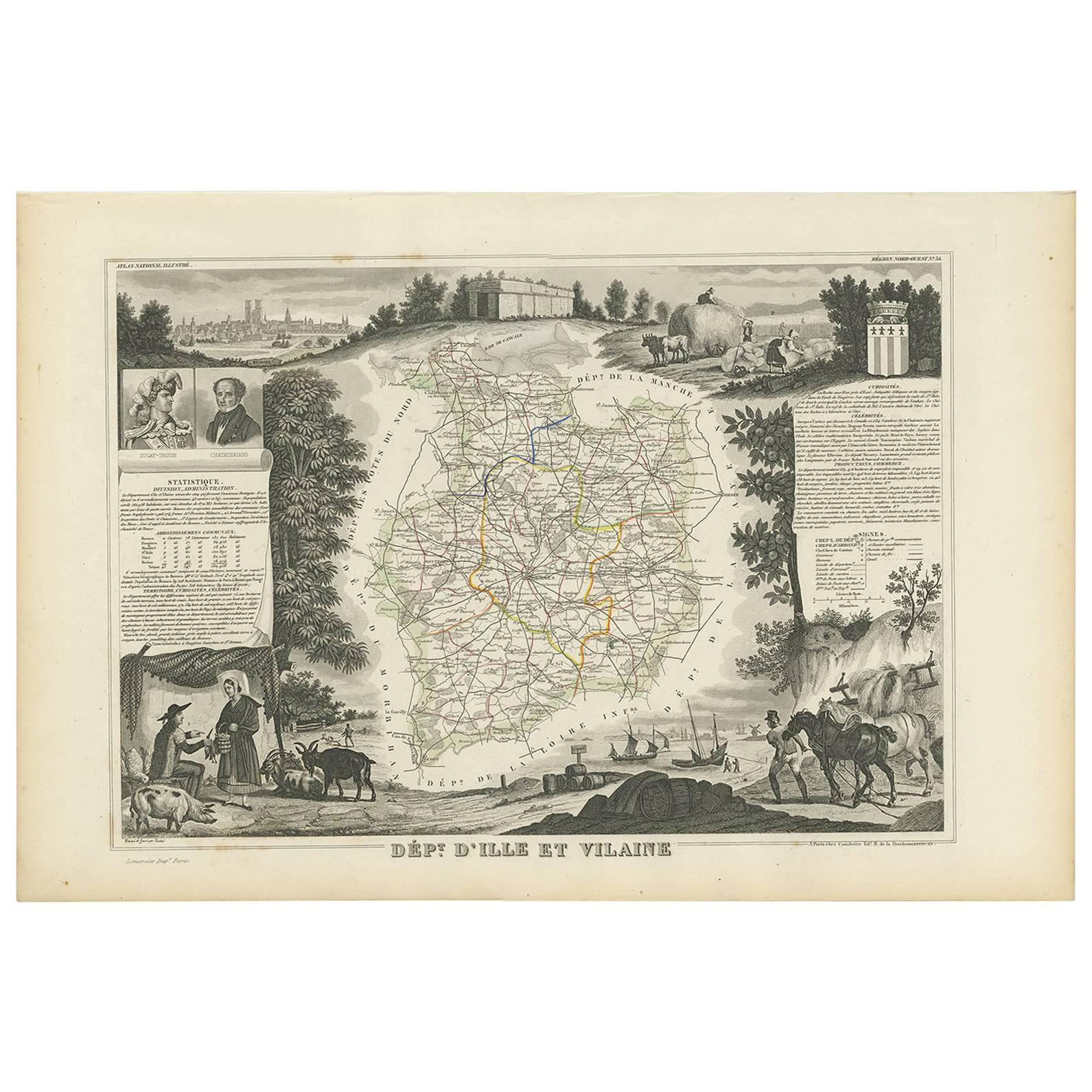
Antique Map of Ille et Vilaine ‘France’ by V. Levasseur, 1854
Located in Langweer, NL
Antique map titled 'Dépt. d'Ille et Vilaine'. Map of the French department of Ille et Vilaine. France. Its coastal area is famous for its seafood, and especially its oysters. The reg...
Category
Antique Mid-19th Century Maps
Materials
Paper
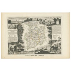
$171 Sale Price
20% Off
Old Map of the French department of Tarn, France
By Victor Levasseur
Located in Langweer, NL
Antique map titled 'Dépt. du Tarn'. Map of the French department of Tarn, France. This area produces a variety of traditional wines, including Cahors, Mauzac, Loin de l’Oeil and Onde...
Category
Antique Mid-19th Century Maps
Materials
Paper
$324 Sale Price
20% Off
You May Also Like
Var, France. Antique map of a French department, 1856
By Victor Levasseur
Located in Melbourne, Victoria
'Dept. du Var', steel engraving with original outline hand-colouring., 1856, from Levasseur's Atlas National Illustre.
Var covers the heart of the French Riviera or Cote d'Azur., and includes the resort cities of Cannes, Nice and San Tropez...
Category
19th Century Naturalistic Landscape Prints
Materials
Engraving

1851 Map of "Independent Tartary", Ric. R018
Located in Norton, MA
1851 Map of
Independent Tartary
"Russia"
Ric.r018
A highly decorative 1851 map of Independent Tartary by John Tallis and John Rapkin. Covers the regions between the Caspian Sea and Lake Bakquash and between Russia and Afghanistan. These include the ancient Silk Route kingdoms of Khiva, Tartaria, Kokand, and Bokhara. Today this region roughly includes Kazakhstan, Uzbekistan, Turkmenistan, Kyrgyzstan, and Tajikistan. This wonderful map offers a wealth of detail for anyone with an interest in the Central Asian portion of the ancient Silk Road. Identifies various caravan routes, deserts, wells, and stopping points, including the cities of Bokhara and Samarkand. Three vignettes by W. Bragg decorate the map, these including an image of Tartars on a Journey, a horseback Bride Chase, and a tartar camp site. Surrounded by a vine motif border. Engraved by J. Rapkin for John Tallis's 1851 Illustrated Atlas .
Tartary Antique Map...
Category
Antique 19th Century Unknown Maps
Materials
Paper

Aude, France. Antique map of a French department, 1856
By Victor Levasseur
Located in Melbourne, Victoria
'Dept. de L' Aude', steel engraving with original outline hand-colouring., 1856, from Levasseur's 'Atlas National Illustre'.
This area of France is famous for its wide variety of v...
Category
19th Century Naturalistic Landscape Prints
Materials
Engraving

L'Herault, France. Antique map of a French department, 1856
By Victor Levasseur
Located in Melbourne, Victoria
'Dept. de Saone et Loire', steel engraving with original outline hand-colouring., 1856, from Levasseur's Atlas National Illustre.
This area is home to a wide variety of vineyards a...
Category
19th Century Naturalistic Landscape Prints
Materials
Engraving

Jura, France. Antique map of a French department, 1856
By Victor Levasseur
Located in Melbourne, Victoria
'Dept. du Jura', steel engraving with original outline hand-colouring., 1856, from Levasseur's 'Atlas National Illustre'.
The Jura wines are very distinctive and unusual, such as V...
Category
19th Century Naturalistic Landscape Prints
Materials
Engraving

Map of Var - Original Lithograph- 19th Century
Located in Roma, IT
Map of Var is an original lithograph realized by an Anonymous artist of the 19th century.
Printed in series of "France Pittoresque", as indicated on the top center.
The state of pr...
Category
19th Century Modern Figurative Prints
Materials
Paper, Lithograph
More Ways To Browse
French Wine Map
Port Wine
Antique Fishing Collectables
Early American Chairs
Hans Muller
Vintage Wood Table With Glass Top
19th Century Square Table
Antonio Bonet
Galle Chairs
Large Chinese Rug
1940s Vintage French Art Deco
20th Century Spanish Table
Antonio Bellini
Retro Fiberglass Furniture
Shipping Crate
Antique Oushak Carpets
Blue Coffee Tables
German Bauhaus Posters