Items Similar to Large Original Antique Map of the Dutchy of Holstein, Germany, ca.1840


Want more images or videos?
Request additional images or videos from the seller
1 of 5
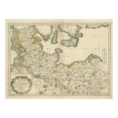
Large Original Antique Map of the Dutchy of Holstein, Germany, ca.1840
About the Item
Antique map titled 'A Map of the Dutchy of Holstein, with the Territories of the Imperial Towns Hamburg & Lubek, Also The Bishoprick of Eutin, Laid down from Fischer's Map (..)'. Scarce regional map of Northern Germany, focused on the Duchy of Holstein and towns of Hamburg and Lubeck. Beautifully engraved to show fortified towns, principal towns, market towns, castles, noblemen's seats, farms, villages, windmills, dykes and topography. Source unknown, to be determined.
Artists and Engravers: James Wyld (1812–1887) was a British geographer and map-seller, best known for Wyld's Great Globe. He was successor to William Faden, one of the luminaries of late eighteenth century publishing in England. Wyld maintained the high standard of graphic and factual excellence that had been established by his predecessor and his maps are among the finest published in the early nineteenth century.
- Dimensions:Height: 23.04 in (58.5 cm)Width: 28.35 in (72 cm)Depth: 0 in (0.02 mm)
- Materials and Techniques:
- Period:
- Date of Manufacture:circa 1840
- Condition:Condition: Good, given age. Small tear bottom margin, not affecting image. A few minor unobtrusive spots. Original middle fold as issued. General age-related toning and/or occasional minor defects from handling. Please study scan carefully.
- Seller Location:Langweer, NL
- Reference Number:Seller: PC-58934 1stDibs: LU3054327384822
About the Seller
5.0
Platinum Seller
These expertly vetted sellers are 1stDibs' most experienced sellers and are rated highest by our customers.
Established in 2009
1stDibs seller since 2017
1,928 sales on 1stDibs
Typical response time: <1 hour
- ShippingRetrieving quote...Ships From: Langweer, Netherlands
- Return PolicyA return for this item may be initiated within 14 days of delivery.
Auctions on 1stDibs
Our timed auctions are an opportunity to bid on extraordinary design. We do not charge a Buyer's Premium and shipping is facilitated by 1stDibs and/or the seller. Plus, all auction purchases are covered by our comprehensive Buyer Protection. Learn More
More From This SellerView All
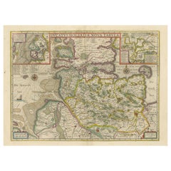
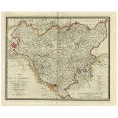
- Antique Map of Holstein, GermanyLocated in Langweer, NLAntique map titled 'Holsatia Ducatus'. Original old map of Holstein, Germany. By Petrus Kaerius, published circa 1650. Pieter van den Keere (Latin: Petrus Kaerius 1571 – circa 1646) ...Category
Antique Mid-17th Century Maps
MaterialsPaper
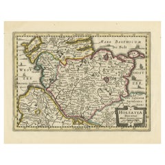
- Original Antique Map of the Duchy of HolsteinBy Willem BlaeuLocated in Langweer, NLAntique map titled 'Ducatus Holsatiae Nova Tabula'. Original old map of the Duchy of Holstein, the northernmost territory of the Holy Roman Empire, from the mid-17th Century. To the ...Category
Antique Mid-17th Century Maps
MaterialsPaper
- Antique Map of Northern Germany, Including Schleswig-Holstein and HamburgLocated in Langweer, NLAntique map titled 'Basse Partie de la Basse Saxe ou sont les Duchés de Sleswick, Holsace, Meckelenbourg et Lauvenbourg (..)'. Original old map of northern Germany, including Schlesw...Category
Antique Mid-17th Century Maps
MaterialsPaper
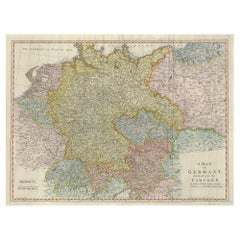
- Large Antique Map of the German EmpireLocated in Langweer, NLAntique map titled 'A Map of Germany (..)'. Large antique map of the German Empire, highly detailed. Engraved by T. Kitchin. Published J. Blair, cir...Category
Antique Late 18th Century Maps
MaterialsPaper
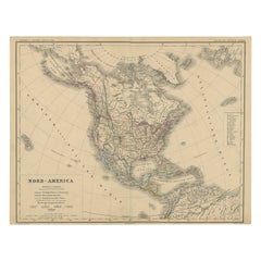
- Old Original Antique German Map of North America, ca.1870Located in Langweer, NLAntique map titled 'Nord-America'. Old map of North America. This map originates from 'H. Kiepert's Kleiner Atlas der Neueren Geographie für Schule und Haus'. Artists and Engrave...Category
Antique 1870s Maps
MaterialsPaper
- Old Map of Holstein with the Imperial Towns Hamburg & Lubeck, Germany, 1854Located in Langweer, NLAntique map titled 'Map of the Duchy of Holstein with the territories of the Imperial Towns Hamburg & Lubeck (..) Based on a map by Fischer.' Map of the Duchy of Holstein. From Jam...Category
Antique 1850s Maps
MaterialsPaper
You May Also Like
- Large Antique 1859 Map of North AmericaLocated in Sag Harbor, NYThis Map was made by Augustus Mitchell in 1859 It is in amazing condition for being 163 years old. This price is for the rolled up easy to ship version of this piece. I will be Frami...Category
Antique Mid-19th Century American Maps
MaterialsCanvas, Paper

- Map of the Republic of GenoaLocated in New York, NYFramed antique hand-coloured map of the Republic of Genoa including the duchies of Mantua, Modena, and Parma. Europe, late 18th century. Dimension: 25...Category
Antique Late 18th Century European Maps
- Antique Map of Principality of MonacoBy Antonio Vallardi EditoreLocated in Alessandria, PiemonteST/619 - "Old Geographical Atlas of Italy - Topographic map of ex-Principality of Monaco" - ediz Vallardi - Milano - A somewhat special edition ---Category
Antique Late 19th Century Italian Other Prints
MaterialsPaper
- Antique 18th Century Map of the Province of Pensilvania 'Pennsylvania State'Located in Philadelphia, PAA fine antique of the colony of Pennsylvania. Noted at the top of the sheet as a 'Map of the province of Pensilvania'. This undated and anonymous map is thought to be from the Gentleman's Magazine, London, circa 1775, although the general appearance could date it to the 1760's. The southern boundary reflects the Mason-Dixon survey (1768), the western boundary is placed just west of Pittsburgh, and the northern boundary is not marked. The map has a number of reference points that likely refer to companion text and appear to be connected to boundaries. The western and southern boundaries are marked Q, R, S, for example. A diagonal line runs from the Susquehanna R to the Lake Erie P. A broken line marked by many letters A, B, N, O, etc., appears in the east. There are no latitude or longitude markings, blank verso. Framed in a shaped contemporary gilt wooden frame and matted under a cream colored matte. Bearing an old Graham Arader Gallery...Category
Antique 18th Century British American Colonial Maps
MaterialsPaper
- Map "Estuary- Mouth of the Thames"Located in Alessandria, PiemonteST/426 - Antique French Map of the estuary of the Thames, map dated 1769 - "Mape of the entrance of the Thames. Designed by filing of Navy cards fo...Category
Antique Mid-18th Century French Other Prints
MaterialsPaper
- Germany West of the Rhine: A Hand-colored 18th Century Map by de WitBy Frederick de WitLocated in Alamo, CAThis original 18th century hand-colored map of the county of Moers, Germany entitled "Illustrissimo Celsissmo Principi GUILIELMO HENRICO D.G. Arausionum Principi Domino suo Clementis...Category
Antique Early 18th Century Dutch Maps
MaterialsPaper


Recently Viewed
View AllMore Ways To Browse
German Furniture Hamburg
Imperial Germany
Imperial German
Antique Large Globe
Village Antique Market
Great Britain Maps
Antique Britain Map
Antique Map Britain
Antique Map Globe
Map Of Great Britain
German Windmill
Antique Farm Windmill
Wyld Globes
General Empire
Wood And Sons Plate
Antique Caribbean
Large World Map
Holland Utrecht