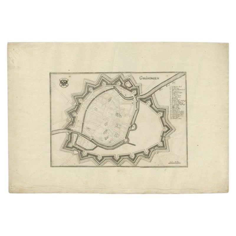
Items Similar to Map of Groningen from The Genealogy of the Illustrious Counts of Nassau (1615)

Want more images or videos?
Request additional images or videos from the seller
1 of 6
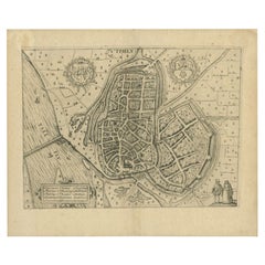
Map of Groningen from The Genealogy of the Illustrious Counts of Nassau (1615)
$527.45
$659.3120% Off
£391.82
£489.7820% Off
€440
€55020% Off
CA$732.43
CA$915.5320% Off
A$799.25
A$999.0620% Off
CHF 419.22
CHF 524.0220% Off
MX$9,707.11
MX$12,133.8820% Off
NOK 5,236.26
NOK 6,545.3320% Off
SEK 4,948.53
SEK 6,185.6620% Off
DKK 3,349.67
DKK 4,187.0920% Off
About the Item
Title: Map of Groningen from "The Genealogy of the Illustrious Counts of Nassau" (1615)
Description: This antique map, titled "Gronenga," offers a detailed depiction of the fortified city of Groningen, located in the northern part of the Netherlands. It was published in 1615 in Jan Jansz. Orlers' historical work, "The Genealogy of the Illustrious Counts of Nassau." Orlers was a prominent Dutch historian, known for his accounts of important Dutch figures and families.
The map showcases the fortifications surrounding Groningen during the early 17th century, with the city's defensive walls, bastions, and surrounding waterworks clearly illustrated. The layout of streets, major buildings, and the city’s key defensive structures are meticulously engraved, offering a glimpse into the city's military and architectural infrastructure during this period. Groningen was a strategic and militarily important city in the Netherlands during the Eighty Years' War.
Surrounding the city, you can observe the countryside and several smaller fortresses, roads, and fields. The canals and rivers that played a vital role in Groningen's defense and trade are prominently shown. The central part of the city, with its network of streets, squares, and important structures such as churches, is carefully detailed, reflecting both the artistic and practical cartography of the period.
This engraving is not only an important piece of cartographic history but also serves as an artistic representation of Groningen during the Dutch Golden Age.
- Artist/Engraver: Jan Jansz. Orlers (1570-1646)
- Technique: Copperplate engraving
- Date: 1615
- Origin: From "The Genealogy of the Illustrious Counts of Nassau"
- Condition: Well-preserved, with clear impressions and fine detailing.
This map would have been used to document the noble history of the House of Nassau, to which the Dutch royal family belongs, and to highlight significant cities like Groningen.
- Dimensions:Height: 11.03 in (28 cm)Width: 13.98 in (35.5 cm)Depth: 0 in (0.02 mm)
- Materials and Techniques:Paper,Engraved
- Period:1610-1619
- Date of Manufacture:1615
- Condition:Good, general age-related toning. Original folding line, blank verso. Please study image carefully.
- Seller Location:Langweer, NL
- Reference Number:Seller: PCT-5611stDibs: LU3054341817732
About the Seller
5.0
Recognized Seller
These prestigious sellers are industry leaders and represent the highest echelon for item quality and design.
Platinum Seller
Premium sellers with a 4.7+ rating and 24-hour response times
Established in 2009
1stDibs seller since 2017
2,641 sales on 1stDibs
Typical response time: <1 hour
- ShippingRetrieving quote...Shipping from: Langweer, Netherlands
- Return Policy
Authenticity Guarantee
In the unlikely event there’s an issue with an item’s authenticity, contact us within 1 year for a full refund. DetailsMoney-Back Guarantee
If your item is not as described, is damaged in transit, or does not arrive, contact us within 7 days for a full refund. Details24-Hour Cancellation
You have a 24-hour grace period in which to reconsider your purchase, with no questions asked.Vetted Professional Sellers
Our world-class sellers must adhere to strict standards for service and quality, maintaining the integrity of our listings.Price-Match Guarantee
If you find that a seller listed the same item for a lower price elsewhere, we’ll match it.Trusted Global Delivery
Our best-in-class carrier network provides specialized shipping options worldwide, including custom delivery.More From This Seller
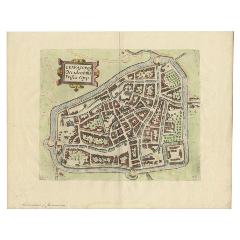
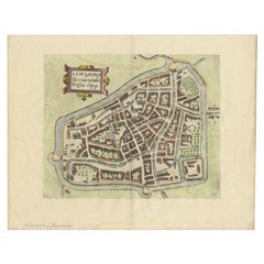
View AllAntique Map of the City of Leeuwarden by Guicciardini, 1613
Located in Langweer, NL
Antique map tited 'Lewardum'. Plan of the city of Leeuwarden, Friesland, the Netherlands. This map originates from the 1613 edition of 'Discrittione di tutti i Paesi Bassi', by L. Gu...
Category
Antique 17th Century Maps
Materials
Paper
$137 Sale Price
20% Off
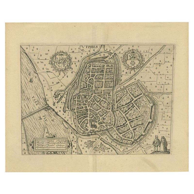
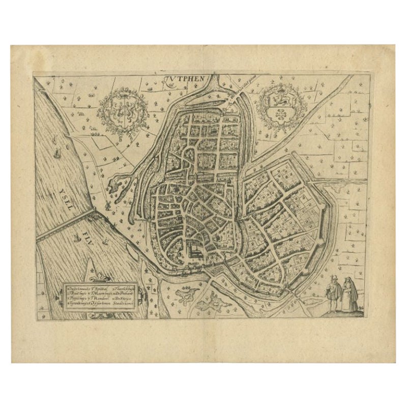
Antique Map of the City of Zutphen by Guicciardini, 1612
Located in Langweer, NL
Antique map Zutphen titled 'Zutphen'. This map depicts the city of Zutphen, Gelderland, The Netherlands. Originates from 'Beschryvinghe van alle de Neder-landen anderssins ghenoemt N...
Category
Antique 17th Century Maps
Materials
Paper

$180 Sale Price
20% Off
Antique Map of the City of Groningen by Merian, 1659
Located in Langweer, NL
Antique map titled 'Gröningen'. This print depicts the city of Groningen, the Netherlands. This print originates from 'Topographia Germaniae Inferioris (..)' by C. Merian.
Artist...
Category
Antique 17th Century Maps
Materials
Paper
$88 Sale Price
20% Off
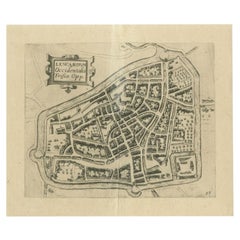
Antique Map of the City of Leeuwarden, The Netherlands, by Guicciardini, 1612
Located in Langweer, NL
Antique map titled 'Lewardum Occidentalis Frisia Opp'. Plan of the city of Leeuwarden, in the province of Friesland, the Netherlands. This map originates from 'Beschryvinghe van alle...
Category
Antique 17th Century Maps
Materials
Paper
Antique Map of the City of Zutphen by Guicciardini, 1613
Located in Langweer, NL
Antique map Zutphen titled 'Zutphen'. This map depicts the city of Zutphen, Gelderland, The Netherlands. Originates from 'Discrittione di tutti i Paesi Bassi'.
Artists and Engrav...
Category
Antique 17th Century Maps
Materials
Paper
$161 Sale Price
20% Off
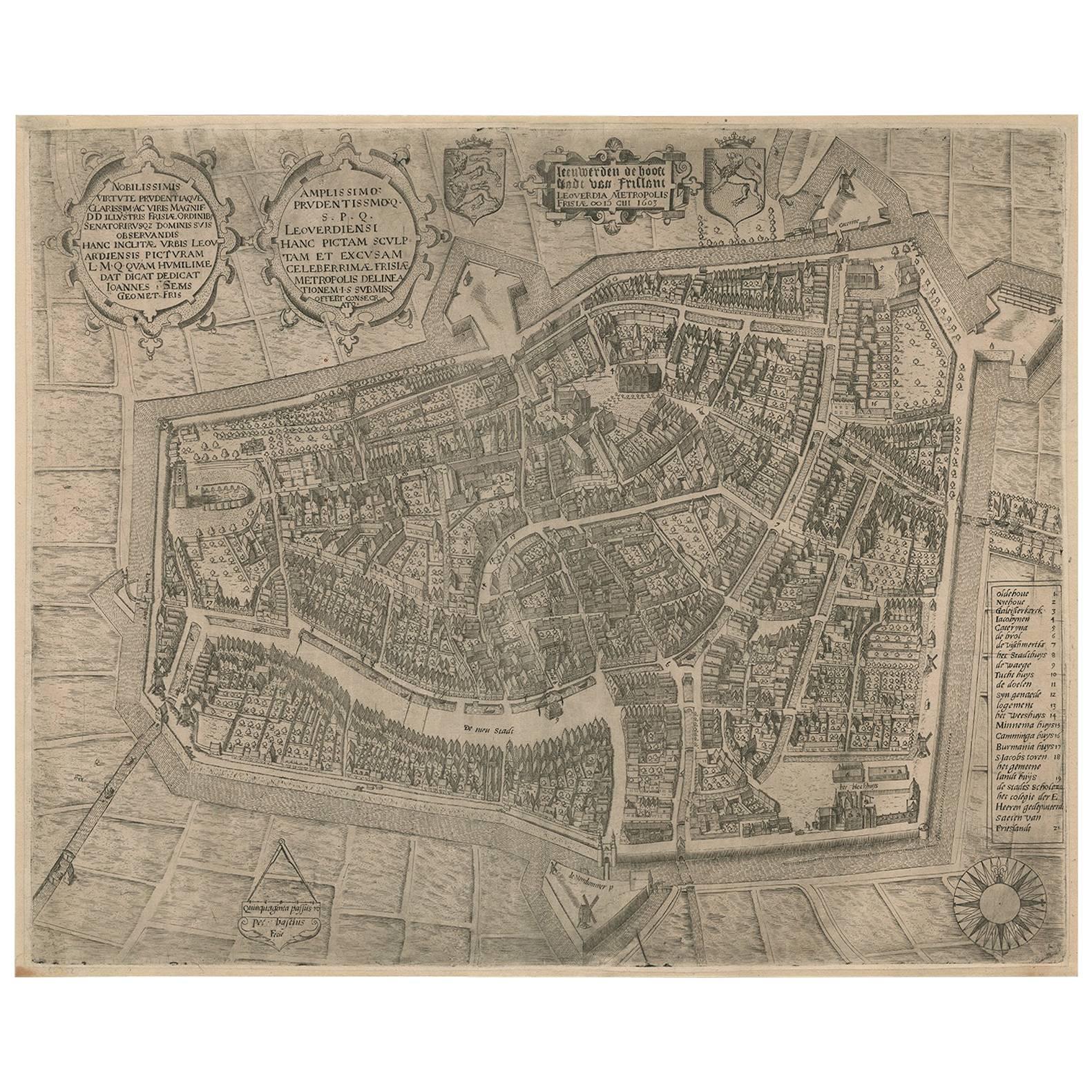
Rare Antique Map of Leeuwarden, Friesland, The Netherlands, by P. Bast, 1603
By P. Bast
Located in Langweer, NL
Very rare plan of Leeuwarden, Friesland, The Netherlands. With several cartouches and coat of arms. With a legend and compass rose at bottom right. Made by 'Pieter Bast' after the su...
Category
Antique Early 17th Century Maps
Materials
Paper

$3,506 Sale Price
35% Off
You May Also Like
Map of Groningen - Etching by George Braun - Late 16th Century
Located in Roma, IT
This map of Groninga is an original etching realized by George Braun and Franz Hogenberg, and part of the series "Civitates Orbis Terrarum".
The state of preservation of the artwork...
Category
16th Century Figurative Prints
Materials
Etching

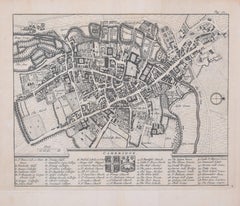
Map of Cambridge, engraving Pieter van der Aa after David Loggan
By Pieter Van Der Aa
Located in London, GB
Pieter van der Aa (1659 - 1733), after David Loggan (1634 - 1692)
Map of Cambridge
Engraving
12 x 16 cm
An eighteenth-century view of Cambridge, engraved by Pieter van der Aa after ...
Category
Early 18th Century Realist Prints and Multiples
Materials
Engraving

Utrecht, Antique Map from "Civitates Orbis Terrarum"
By Franz Hogenberg
Located in Roma, IT
Braun G., Hogenberg F., Traiectum or Utrecht, from the collection Civitates Orbis Terrarum, Cologne, T. Graminaeus, 1572-1617.
Very fine B/W aquatint showing a view of Utrecht, with...
Category
16th Century Landscape Prints
Materials
Etching

$359 Sale Price
25% Off
Map of the Netherlands - Etching by G. Braun and F. Hogenberg -Late 16th Century
By Franz Hogenberg
Located in Roma, IT
Map of the Netherlands is an original etching realized by George Braun and Franz Hogenberg, as part of the "Civitates Orbis Terrarum".
The “Civitates Orbis Terrarum” (Atlas of Citi...
Category
16th Century Figurative Prints
Materials
Etching

1752 Vaugoundy Map of Flanders : Belgium, France, and the Netherlands, Ric.a002
Located in Norton, MA
Large Vaugoundy Map of Flanders:
Belgium, France, and the Netherlands
Colored -1752
Ric.a002
Description: This is a 1752 Didier Robert de Vaugondy map of Flanders. The map de...
Category
Antique 17th Century Unknown Maps
Materials
Paper

Pieter van der Aa: Map of Cambridge, after David Loggan
By Pieter Van Der Aa
Located in London, GB
Pieter van der Aa (1659-1733), after David Loggan (1634–1692)
Map of Cambridge
12 x 16 cm
Engraving (1727)
An eighteenth-century map of Cambridge eng...
Category
Early 18th Century Realist Prints and Multiples
Materials
Engraving
More Ways To Browse
Dutch Royal
Black Scandinavian Modern Dining Chairs
Gold Modern Coffee Table
Round Glass Coffee Tables
18th Century Wood Side Tables
Antique Hand Carved Dining Room Sets
Mid Century Modern Pitcher
Vintage Italian Leather Dining Chair
Vintage Movie Posters
Blue Green Wool And Silk Rug
Brown Sheepskin Chair
Vintage Brass Bar Carts
Antique Botanical Prints
Green Persian Rug
17th Century Blue And White
50 X 50 Coffee Table
Antique Wood Panel Painted
Milo Baughman 1970