Items Similar to Map of Lake Geneva and Surroundings by Hondius, Geneva Region, circa 1612


Want more images or videos?
Request additional images or videos from the seller
1 of 10
Map of Lake Geneva and Surroundings by Hondius, Geneva Region, circa 1612
$647.33
£480.87
€540
CA$898.89
A$980.89
CHF 514.49
MX$11,913.27
NOK 6,426.32
SEK 6,073.20
DKK 4,110.96
About the Item
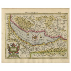
Map of Lake Geneva and Surroundings by Hondius, Geneva Region, 1606
This rare and intricately engraved map, titled *Chorographica Tabula Lacus Lemanni Locorumque Circumiacentium*, was created by Jodocus Hondius and first published in the 1606 edition of the Mercator-Hondius Atlas. Oriented with southeast at the top, the map offers a rich and detailed portrayal of Lake Geneva (Lacus Lemannus) and its surrounding regions, including parts of modern-day Switzerland and France.
The map centers on Lake Geneva, with the Rhône River entering from the east and exiting through the city of Geneva on the west. Surrounding areas are labeled with impressive density, depicting towns, castles, forests, vineyards, and mountain ranges in vivid pictorial style. Elegant embellishments, such as ships sailing on the lake, a compass rose, geese along the shoreline, and even a subtle sea monster, lend charm and visual interest.
Jodocus Hondius, one of the most significant figures in early Dutch cartography, acquired Gerardus Mercator’s plates in 1604. With his own additions, Hondius published a vastly expanded atlas that came to dominate the map market for several decades. This particular plate reflects his close attention to local topography and political context.
Historical annotations enhance the map’s value to historians. A reference to the 1584 earthquake near Yvorne demonstrates Hondius' interest in contemporary events. Several fortresses and locations are identified in relation to the Franco-Savoyard War of 1600–1601, including the Château de l’Echelle and Fort Sainte Catherine. These details situate the map not only as a geographic record but also as a document of military and political significance.
Early editions of this map also featured portraits of Protestant theologians such as Calvin, Farel, and Beza. These were later masked from the plate, likely to appeal to a broader European audience. The present version—post-1612—shows the plate with the portraits removed but still retains the broader framing margin from the original state.
Condition Report:
Engraving in good condition with light age toning, a few marginal stains, and a wide lower margin indicating the masked-off area from the original plate. No significant tears or restoration. Fine plate impression with clear detail.
Tips for Framing:
Use a classic frame in dark walnut or antiqued gold. Choose an archival off-white or beige mat to enhance the aged paper tone. A deep-set shadowbox style can emphasize the generous lower margin and visual depth of this early map. UV glass is recommended.
- Dimensions:Height: 17.45 in (44.3 cm)Width: 21.46 in (54.5 cm)Depth: 0.01 in (0.2 mm)
- Materials and Techniques:Paper,Engraved
- Place of Origin:
- Period:Early 17th Century
- Date of Manufacture:circa 1612
- Condition:Engraving in good condition with light age toning, a few marginal stains, and a wide lower margin indicating the masked-off area from the original plate. No significant tears or restoration. Fine plate impression with clear detail.
- Seller Location:Langweer, NL
- Reference Number:Seller: BG-13667-21stDibs: LU3054345323932
About the Seller
5.0
Recognized Seller
These prestigious sellers are industry leaders and represent the highest echelon for item quality and design.
Platinum Seller
Premium sellers with a 4.7+ rating and 24-hour response times
Established in 2009
1stDibs seller since 2017
2,641 sales on 1stDibs
Typical response time: <1 hour
- ShippingRetrieving quote...Shipping from: Langweer, Netherlands
- Return Policy
Authenticity Guarantee
In the unlikely event there’s an issue with an item’s authenticity, contact us within 1 year for a full refund. DetailsMoney-Back Guarantee
If your item is not as described, is damaged in transit, or does not arrive, contact us within 7 days for a full refund. Details24-Hour Cancellation
You have a 24-hour grace period in which to reconsider your purchase, with no questions asked.Vetted Professional Sellers
Our world-class sellers must adhere to strict standards for service and quality, maintaining the integrity of our listings.Price-Match Guarantee
If you find that a seller listed the same item for a lower price elsewhere, we’ll match it.Trusted Global Delivery
Our best-in-class carrier network provides specialized shipping options worldwide, including custom delivery.More From This Seller
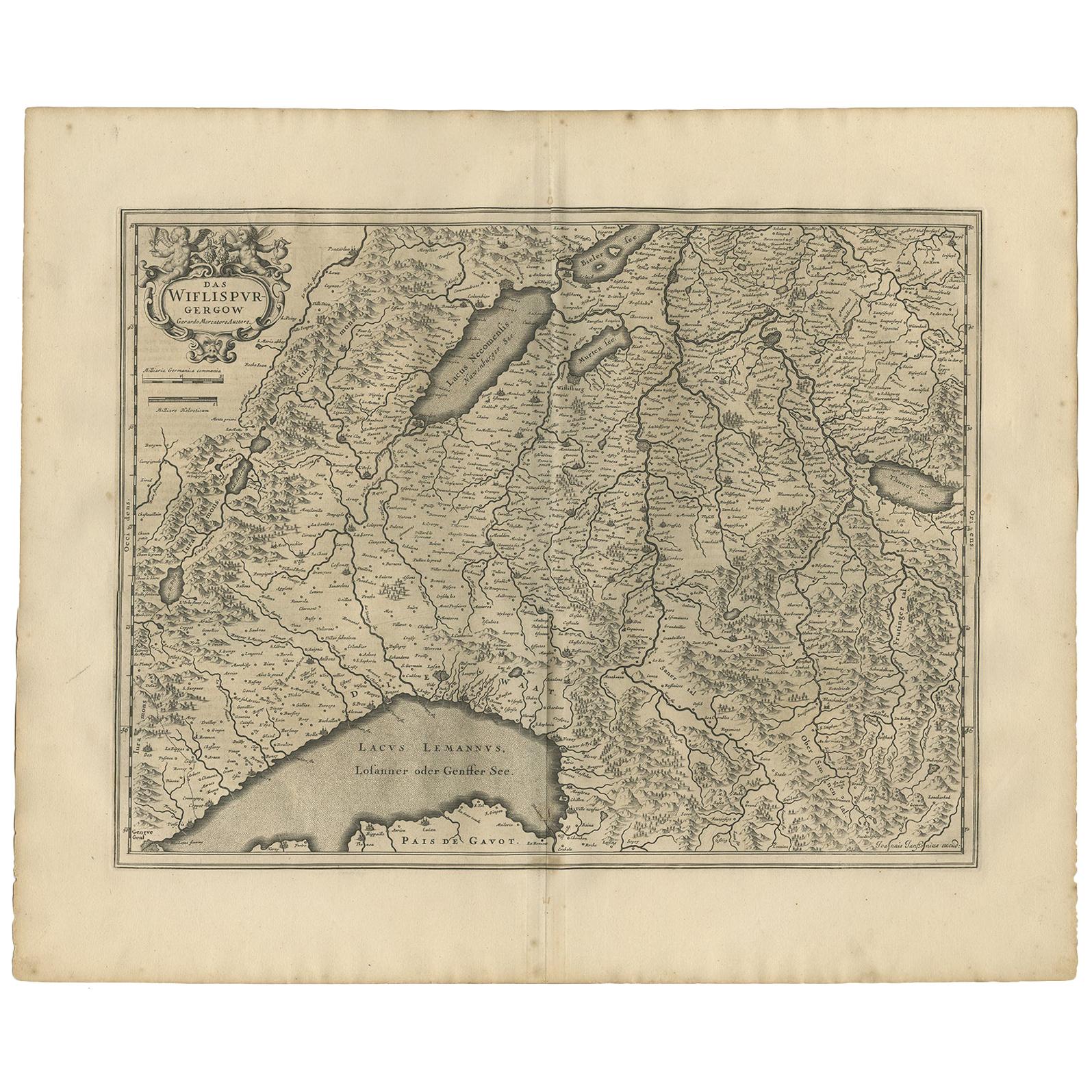
View AllAntique Map of the Region of Lake Geneva by Janssonius '1657'
By Johannes Janssonius
Located in Langweer, NL
Antique map 'Das Wiflispur Gergow'. Detailed map of Switzerland showing Waadt and the Lake of Geneva and the city of Geneva, Fribourg and partly Bern. This map originates from 'Atlas...
Category
Antique Mid-17th Century Maps
Materials
Paper
$527 Sale Price
20% Off
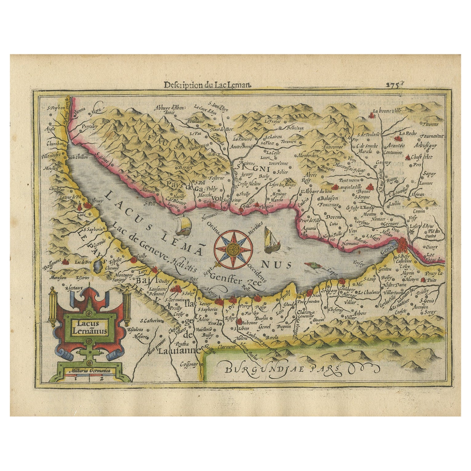
Beautiful Original Copper Engraved Map of Lake Geneva in Switzerland, 1613
Located in Langweer, NL
Description: Antique map titled 'Lacus Lemanus'.
Old map of Lake Geneva with good detail of surrounding towns and villages. Decorated with a large compass rose with two sailing boats and a sea monster in the lake. Originates from 'Atlas Minor'.
Artists and Engravers: Henricus Hondius...
Category
Antique 1610s Maps
Materials
Paper
$623 Sale Price
20% Off
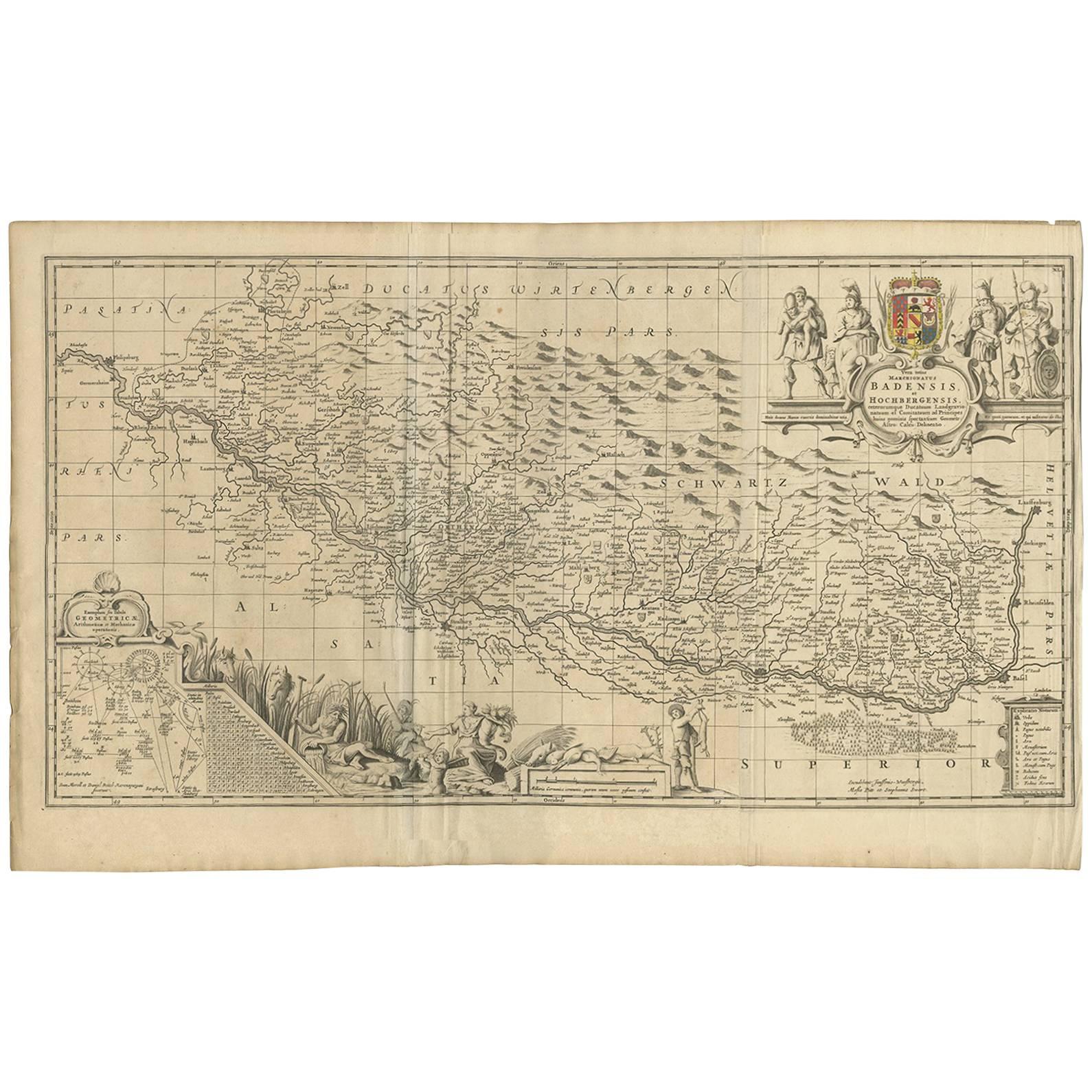
Antique Map of Switzerland by J. van Waesbergen, circa 1680
Located in Langweer, NL
Antique map titled 'Vera totius marchionatus Badensis, et Hochbergensis ; ceterorumque ducatuum ladngravionatuum et comitatuum ad principes huius nominis spectantium geometr: astro: ...
Category
Antique Late 17th Century Maps
Materials
Paper
$786 Sale Price
20% Off
Antique Map of Styria by Mercator 'circa 1650'
Located in Langweer, NL
Antique map titled 'Stiria'. Original antique map of Styria, Austria. Published by G. Mercator, circa 1650.
Category
Antique Mid-17th Century Maps
Materials
Paper

$431 Sale Price
20% Off
Antique Map of Northern Switzerland by Janssonius '1657'
By Johannes Janssonius
Located in Langweer, NL
Antique map 'Zurichgow et Basiliensis provincia'. Detailed map of northern Switzerland, including Zurich and Basel. This map originates from 'Atlas Novus, Sive Theatrum Orbis Orbis T...
Category
Antique Mid-17th Century Maps
Materials
Paper

$527 Sale Price
20% Off
Antique Map of Switzerland by Janssonius, 1657
Located in Langweer, NL
Antique map of Switzerland titled 'Helvetiae Rhetiae & Valesiae'. Decorative and detailed map of Switzerland. This map originates from 'Atla...
Category
Antique 17th Century Maps
Materials
Paper

$502 Sale Price
20% Off
You May Also Like
Original Antique Map of Switzerland, Engraved By Barlow, Dated 1807
Located in St Annes, Lancashire
Great map of Switzerland
Copper-plate engraving by Barlow
Published by Brightly & Kinnersly, Bungay, Suffolk.
Dated 1807
Unframed.
Category
Antique Early 1800s English Maps
Materials
Paper

1592 Abraham Ortelius Map "Lorraine: Lotharingiae Nova Descripti, Ric.A005
Located in Norton, MA
1592 Abraham Ortelius map entitled
"Lorraine: Lotharingiae Nova Descripti
Ric.a005
Description: Ortelius is best known for producing the atlas from which this map comes from, "...
Category
Antique 16th Century Dutch Maps
Materials
Paper

1627 Hendrik Hondius Map Entitled "Vltoniae Orientalis Pars, " Ric.a009
Located in Norton, MA
1627 Hendrik Hondius map entitled
"Vltoniae orientalis pars,"
Ric.a009
Title:
Vltoniae orientalis : pars
Title (alt.) :
Ultoniae orientalis pars
Creator:
Mercator, Gerh...
Category
Antique 17th Century Dutch Maps
Materials
Paper

Engraving Depicting 16th Century Map of Terra Sancta
Located in Buchanan, MI
Abraham Ortelius (Flemish, 1527-1598) Terra Sancta.
Engraving depicting 16th century map of Terra Sancta. Site 15" x 19.5.
Category
Antique 18th Century and Earlier Maps
Materials
Paper

1597 German Map of Alexandria by Georg Braun and Frans Hogenberg
By Georg Braun and Frans Hogenberg
Located in Chapel Hill, NC
1597 Map of Alexandria by Georg Braun and Frans Hogenberg, Germany. From "Civitas Orbis Terrarum", part 2, published in Cologne by Bertram Buchholz. Printed in 2 parts. Title: "Alexa...
Category
Antique 16th Century German Renaissance Maps
Materials
Paper

17th Century Nicolas Visscher Map of Southeastern Europe
Located in Hamilton, Ontario
A beautiful, highly detailed map of southeastern Europe by Nicolas Visscher. Includes regions of Northern Italy (showing the cities Bologna, Padua, and Venice), Bohemia, Austria (sho...
Category
Antique 17th Century Dutch Maps
Materials
Paper

$1,350 Sale Price
38% Off
More Ways To Browse
Antique Portrait Plates
Sea Monster
Antique Earthquake
Used Furniture Geneva
Cream Soup
Early English Silver
Paisley Rugs and Carpets
Black And Chrome Lounge Chair
Vintage 1930 Dining Room Set
Antique Brass And Copper
Antique Cow
Antique Harvest
Antique Victorian Dining Tables
Environment Furniture
Italian Plastic Chairs
Made In Belgium
Black Crystal Glasses
French Mid Century Modern Rug