Items Similar to Map of the Persian Empire by Nicolas Sanson, Hand-colored, circa 1683
Want more images or videos?
Request additional images or videos from the seller
1 of 10
Map of the Persian Empire by Nicolas Sanson, Hand-colored, circa 1683
$441.73
£329.60
€370
CA$615.97
A$674.81
CHF 352.51
MX$8,112.53
NOK 4,406.93
SEK 4,156.44
DKK 2,817.47
About the Item
Map of the Persian Empire by Nicolas Sanson, hand-colored, circa 1683
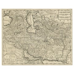
This finely detailed and delicately hand-colored map titled *L'Empire du Sophy des Perses* presents a late 17th-century view of the Persian Empire, covering a wide region including modern-day Iran, Iraq, Kuwait, southern parts of the Caucasus, and western Pakistan. The map was designed by Nicolas Sanson, the royal geographer to the French King, and engraved by Antoine d’Winter. This example was likely issued around 1683 as part of *Geographise en Historise Werelt Beschryving*, a Dutch adaptation of Sanson’s influential small-format atlases.
The map captures the political and geographical structure of the Persian Empire under the Safavid dynasty, known to European audiences as the “Empire of the Sophy.” Topographical details such as rivers, mountain ranges, and deserts are depicted, along with numerous place names—both classical and then-contemporary—including major cities such as Isfahan, Shiraz, Baghdad, and Basra. Borders are outlined in original hand color, dividing key regions such as Chorasan, Kirman, Arack Agemi, and more.
To the north is the Caspian Sea, labeled *Mer de Baccu ou de Sala*, and the *Mer d’Arabie* (Arabian Sea) is shown at the southern boundary, along with the entrance to the Persian Gulf and the mouth of the Indus River. The title is elegantly framed in a green laurel wreath cartouche, a signature element of Sanson’s map design.
This particular map has a rich production history. While originally engraved in the 1650s by A. Peyrounin, this smaller version was re-engraved by Antoine d’Winter for editions published by Ribbius and de Vries in the early 1680s. The plates changed hands multiple times through the 18th century, a testament to their enduring value and clarity.
An excellent addition to any collection of antique maps of the Middle East or Persian Empire.
Condition Report:
Excellent early impression on bright paper with full margins. Light spots in the Arabian Sea area. Watermark with arrow visible. No tears or repairs. Hand coloring is well-preserved and attractive.
Framing Tips:
Frame in a gold or dark wood moulding with an ivory or tan mat to accent the warm hand coloring. Float mounting is recommended to display the full plate and plate mark. Use UV-protective glass to preserve paper and pigment.
- Dimensions:Height: 8.75 in (22.2 cm)Width: 13 in (33 cm)Depth: 0.01 in (0.2 mm)
- Materials and Techniques:Paper,Engraved
- Period:1680-1689
- Date of Manufacture:circa 1683
- Condition:Excellent early impression on bright paper with full margins. Light spots in the Arabian Sea area. Watermark with arrow visible. No tears or repairs. Hand coloring is well-preserved and attractive.
- Seller Location:Langweer, NL
- Reference Number:Seller: BG-140631stDibs: LU3054345121352
About the Seller
5.0
Recognized Seller
These prestigious sellers are industry leaders and represent the highest echelon for item quality and design.
Platinum Seller
Premium sellers with a 4.7+ rating and 24-hour response times
Established in 2009
1stDibs seller since 2017
2,654 sales on 1stDibs
Typical response time: <1 hour
- ShippingRetrieving quote...Shipping from: Langweer, Netherlands
- Return Policy
Authenticity Guarantee
In the unlikely event there’s an issue with an item’s authenticity, contact us within 1 year for a full refund. DetailsMoney-Back Guarantee
If your item is not as described, is damaged in transit, or does not arrive, contact us within 7 days for a full refund. Details24-Hour Cancellation
You have a 24-hour grace period in which to reconsider your purchase, with no questions asked.Vetted Professional Sellers
Our world-class sellers must adhere to strict standards for service and quality, maintaining the integrity of our listings.Price-Match Guarantee
If you find that a seller listed the same item for a lower price elsewhere, we’ll match it.Trusted Global Delivery
Our best-in-class carrier network provides specialized shipping options worldwide, including custom delivery.More From This Seller
View AllMap of the Persian Empire circa 1750 by Tirion – Hand-Colored Dutch Map
Located in Langweer, NL
Map of the Persian Empire circa 1750 by Tirion – Hand-Colored Dutch Map
This finely detailed antique map titled "Nieuwe Kaart van 't Ryk van Persie" (New Map of the Empire of Persia...
Category
Antique 1750s Dutch Maps
Materials
Paper
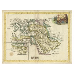
1742 Antique Map of the Persian Empire with Detailed Borders and Cartouche
Located in Langweer, NL
Title: 1742 Covens & Mortier Map of the Persian Empire by Guillaume De L'Isle
This remarkable 1742 map, "Carte de Perse," was originally designed by Guillaume De L'Isle, a preemin...
Category
Antique 1740s Dutch Maps
Materials
Paper
$1,547 Sale Price
20% Off
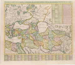
18th-Century Map of the Eastern Roman Empire by Henri Chatelain, c. 1719
Located in Langweer, NL
Title: 18th-Century Map of the Eastern Roman Empire by Henri Chatelain, c. 1719
Description: This intricately detailed map, titled *Nouvelle Carte pour Servir à l'Histoire de l'Empi...
Category
Antique 1710s Maps
Materials
Paper
Map of Persia, the Caspian & India – Isaak Tirion, c.1730
Located in Langweer, NL
Map of Persia and Surrounding Regions – “Nieuwe Kaart van 't Ryck van Persie” by Isaak Tirion, Amsterdam, c. 1730
This finely detailed copperplate map titled “Nieuwe Kaart van 't Ry...
Category
Antique Mid-18th Century Dutch Maps
Materials
Paper
Authentic Old Map of Persia with Original Border Coloring, 1745
Located in Langweer, NL
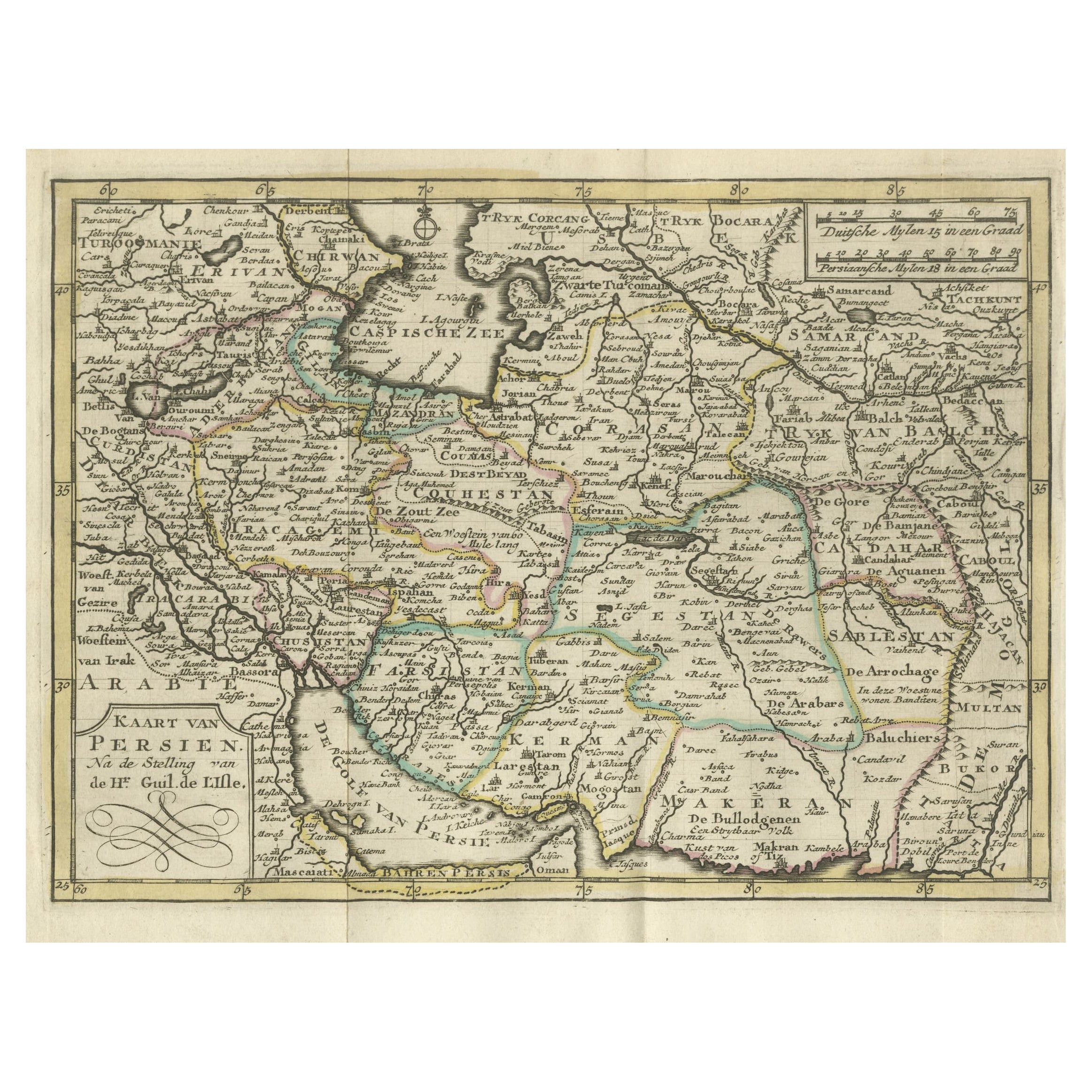
Title: "Kaartje van Persien na de stelling van den Heer Guillaume de L'Isle"
Translates to "Map of Persia based on the work of Mr. Guillaume de L'Isle." Guillaume de L'Isle was a p...
Category
Antique 1740s Maps
Materials
Paper

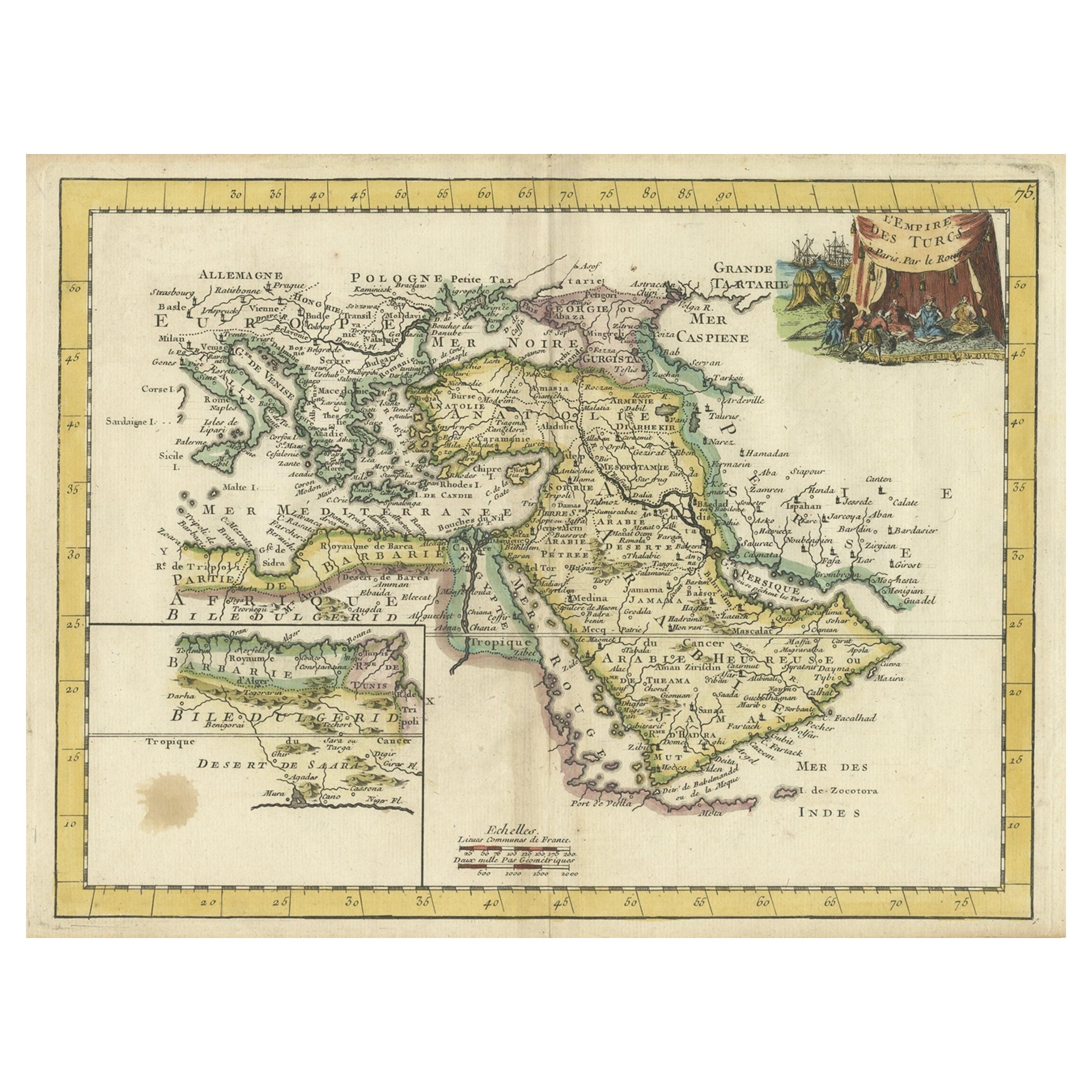
Orginal Antique Handcolored Map of the Turkish Empire, 1748
Located in Langweer, NL
Antique map titled 'L'Empire des Turcs'. Old map of the Turkish Empire with an inset of the North African regions. Originates from 'Atlas Nouveau Portatif' by G.L. le Rouge.
Artis...
Category
Antique 18th Century Maps
Materials
Paper
$341 Sale Price
35% Off
You May Also Like
Southern Greece: A Large 17th Century Hand-colored Map By Sanson and Jaillot
By Nicholas Sanson d'Abbeville
Located in Alamo, CA
This large original hand-colored copperplate engraved map of southern Greece and the Pelopponese Peninsula entitled "La Moree Et Les Isles De Zante, Cefalonie, Ste. Marie, Cerigo & C...
Category
1690s Landscape Prints
Materials
Engraving

Southern & Eastern Europe: A Large 17th C. Hand-colored Map by Sanson & Jaillot
By Nicholas Sanson d'Abbeville
Located in Alamo, CA
This large hand-colored map entitled "Estats de L'Empire des Turqs en Europe, ou sont les Beglerbeglicz our Gouvernements" was originally created by Nicholas Sanson d'Abbeville and this version was published by Hubert Jaillot in "Atlas Nouveau" in Paris in 1692. It depicts the territories of the Ottoman Empire in Europe, predominantly Eastern Europe. Highlights include, the Mediterranean Sea, the Adriatic Sea, the Black Sea, the Dalmation Coast including present day Croatia, Bosnia and Herzegovina, Montenegro, Serbia, Slovenia, Italy, Greece, North Macedonia, Turkey, Romania, Hungary, Albania, Kosovo, Bulgaria, Transylvania, Moldova and southern portions of France, Switzerland, Germany, and Poland..
The map consists of two sheets joined as one along a vertical joint. The map has original hand-coloring. It is printed on antique hand-made laid, chain-linked paper with wide margins. The sheet measures 24.88" high and 38" wide. There is a central vertical joint, as issued. The map is in very good condition.
Nicholas Sanson d'Abbeville (1600-1667) was one of the greatest French cartographather of French cartography. Sanson opened his first printing business in Paris in 1638. The king recognized his skill and knowledge and made him the official geographer to the court. He eventually served two kings in this capacity. Sanson was succeeded by his sons and son...
Category
1690s Landscape Prints
Materials
Engraving

Map of the East Indies: An Original 18th Century Hand-colored Map by E. Bowen
Located in Alamo, CA
This is an original 18th century hand-colored map entitled "An Accurate Map of the East Indies Exhibiting the Course of the European Trade both on the Continent and Islands" by Emanu...
Category
Mid-18th Century Old Masters Landscape Prints
Materials
Engraving

1640 Willem Blaeu Map Entitled "Contado di molise et principato vltra, " Ric.a003
By Willem Blaeu
Located in Norton, MA
1640 Willem Blaeu map entitled
"Contado di molise et principato vltra,"
Colored
Ric. a003
Measures: 38 x 49.6 cm and wide margins
DBLAEU.
Cou...
Category
Antique 17th Century Dutch Maps
Materials
Paper

West Germany: Original Hand Colored 17th Century Map by Johannes Janssonius
By Johannes Janssonius
Located in Alamo, CA
An original hand colored copperplate engraved map entitled in Latin "Archiepiscopatus Maghdeburgensis et Anhaltinus Ducatus cum terris adjacentibus", published in Amsterdam in 1640 i...
Category
Mid-17th Century Old Masters More Prints
Materials
Engraving

Persiae, Armeniae, Natoliae et Arabiae Descriptio per Frederick deWit 1666 map
Located in Paonia, CO
Map of Persiae, Armeniae, Natoliae et Arabiae Descriptio per F de Wit 1688 engraving from: Atlas Contractus Orbis Terrarum Praecipuas ac Novissimas Complectens Tabulas. Amsterdam, N. Visscher, 1656-77. (Koeman III, Vis5-8) This highly decorative map of the Middle East is by the Dutch engraver, publisher, and map seller...
Category
1660s Realist Landscape Prints
Materials
Engraving

More Ways To Browse
Antique Hand Warmer
17th Century Dutch Wood Frames
Round Table Base
Cream Soup
Early English Silver
James Bond
Paisley Rugs and Carpets
Antique Pagoda
Black And Chrome Lounge Chair
Ceramic 1960s Italy
Vintage 1930 Dining Room Set
Antique Brass And Copper
Antique Cow
Antique Harvest
Antique Victorian Dining Tables
Environment Furniture
Italian Plastic Chairs
Made In Belgium