Items Similar to Neatly Framed Decorative Hand-Colored View of Zierikzee, the Netherlands, 1858
Want more images or videos?
Request additional images or videos from the seller
1 of 6
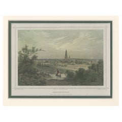
Neatly Framed Decorative Hand-Colored View of Zierikzee, the Netherlands, 1858
About the Item
Antique print titled 'Zierikzee'.
View of the city of Zierikzee, the Netherlands. This print originates from 'Het koningrijk der Nederlanden voorgesteld in eene reeks van 136 naar de natuur geteekende schilderachtige gezigten' authored by J. L. Terwen and published by G.B. van Goor in Gouda, 1858.
Artists and engravers: Johannes Leonardus Terwen (1813-1873). Terwen enjoyed a good education to become a teacher. On July 14, 1840 he became the principal of the 'Bijzondere School' in Gouda. Later he was a teacher at the latin school in Gouda, but he seemed to experience a larger calling to become an author.
- Dimensions:Height: 11.93 in (30.3 cm)Width: 13.47 in (34.2 cm)Depth: 0 in (0.02 mm)
- Materials and Techniques:
- Period:
- Date of Manufacture:1858
- Condition:Condition: Very good, general age-related toning. Frame included, lightly used. Please study image carefully.
- Seller Location:Langweer, NL
- Reference Number:Seller: BG-114451stDibs: LU3054327312012
About the Seller
5.0
Recognized Seller
These prestigious sellers are industry leaders and represent the highest echelon for item quality and design.
Platinum Seller
Premium sellers with a 4.7+ rating and 24-hour response times
Established in 2009
1stDibs seller since 2017
2,435 sales on 1stDibs
Typical response time: 1 hour
- ShippingRetrieving quote...Shipping from: Langweer, Netherlands
- Return Policy
Authenticity Guarantee
In the unlikely event there’s an issue with an item’s authenticity, contact us within 1 year for a full refund. DetailsMoney-Back Guarantee
If your item is not as described, is damaged in transit, or does not arrive, contact us within 7 days for a full refund. Details24-Hour Cancellation
You have a 24-hour grace period in which to reconsider your purchase, with no questions asked.Vetted Professional Sellers
Our world-class sellers must adhere to strict standards for service and quality, maintaining the integrity of our listings.Price-Match Guarantee
If you find that a seller listed the same item for a lower price elsewhere, we’ll match it.Trusted Global Delivery
Our best-in-class carrier network provides specialized shipping options worldwide, including custom delivery.More From This Seller
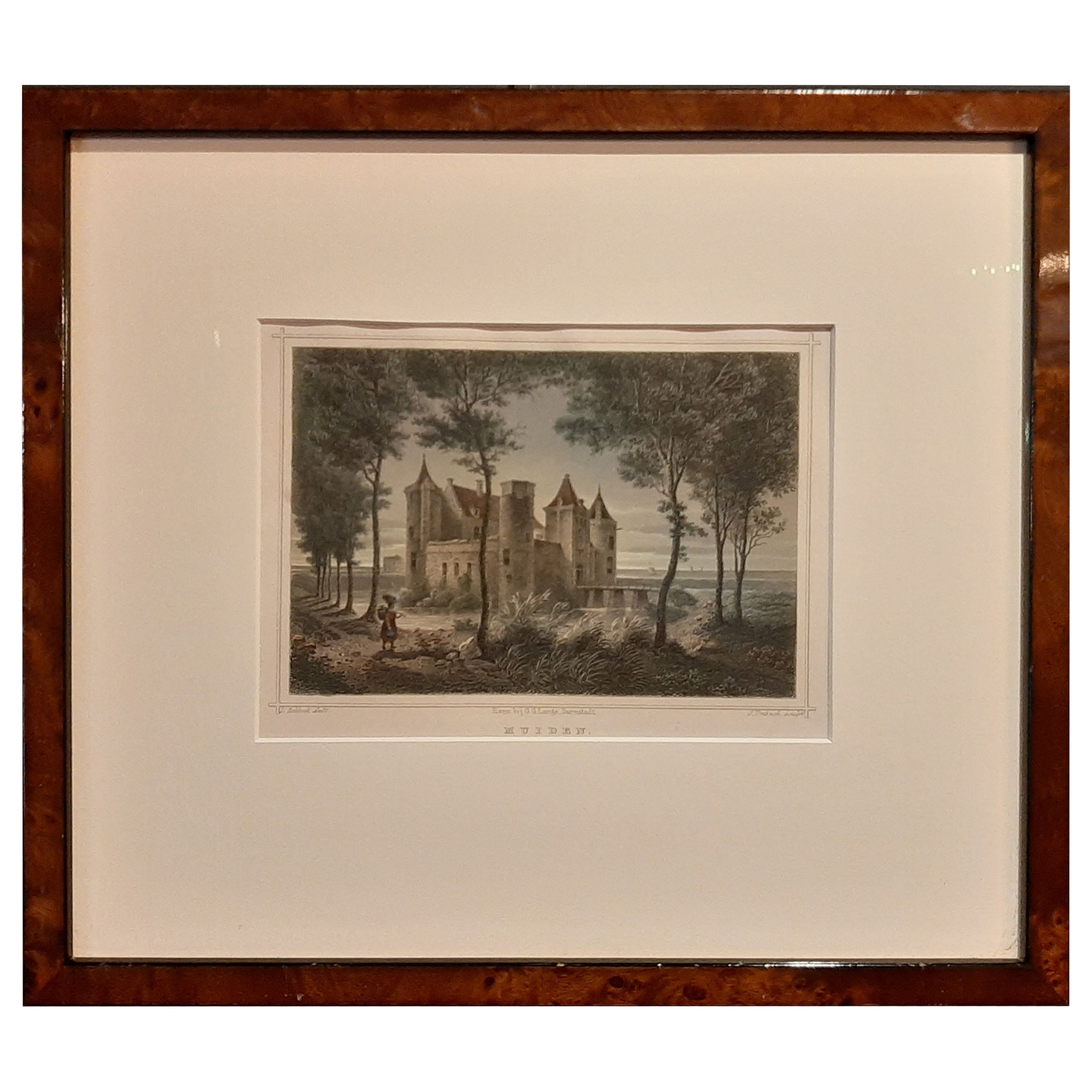
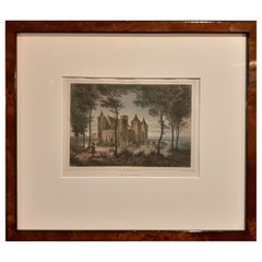
View AllNicely Framed View of Muiden Castle, the Netherlands, 1858
Located in Langweer, NL
Antique print titled 'Muiden'. View of Muiden Castle, the Netherlands. This print originates from 'Het koningrijk der Nederlanden voorgesteld in eene reeks van 136 naar de natuur get...
Category
Antique 1850s Prints
Materials
Paper
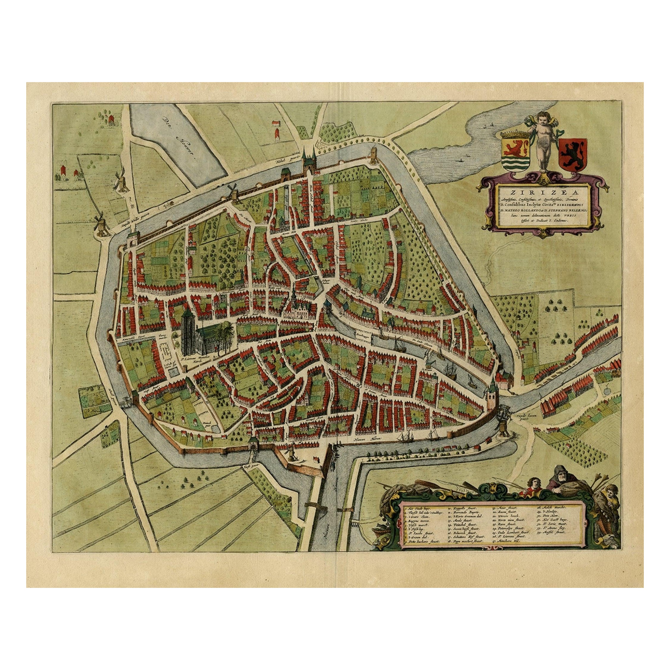
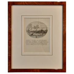
Antique Bird's-eye View Plan of Zierikzee in Zeeland, The Netherlands, 1649
Located in Langweer, NL
Antique print, titled: 'Zirizea.' - A bird's-eye view plan of Zierikzee in The Netherlands, with key to locations and coats of arms. After Matheo Rollando and Stephano Bellemo. Latin tekst on verso. From the city Atlas: 'Toneel der Steeden' published by Joan Blaeu...
Category
Antique 1640s Maps
Materials
Paper
$1,066 Sale Price
20% Off
Nicely Hand-Colored View of the City of Amersfoort, The Netherlands, 1858
Located in Langweer, NL
Antique print titled 'Amersfoort van den Appelenweg gezien'.
View of the city of Amersfoort, the Netherlands. This print originates from 'Het koningrijk der Nederlanden voorgeste...
Category
Antique 1850s Prints
Materials
Paper
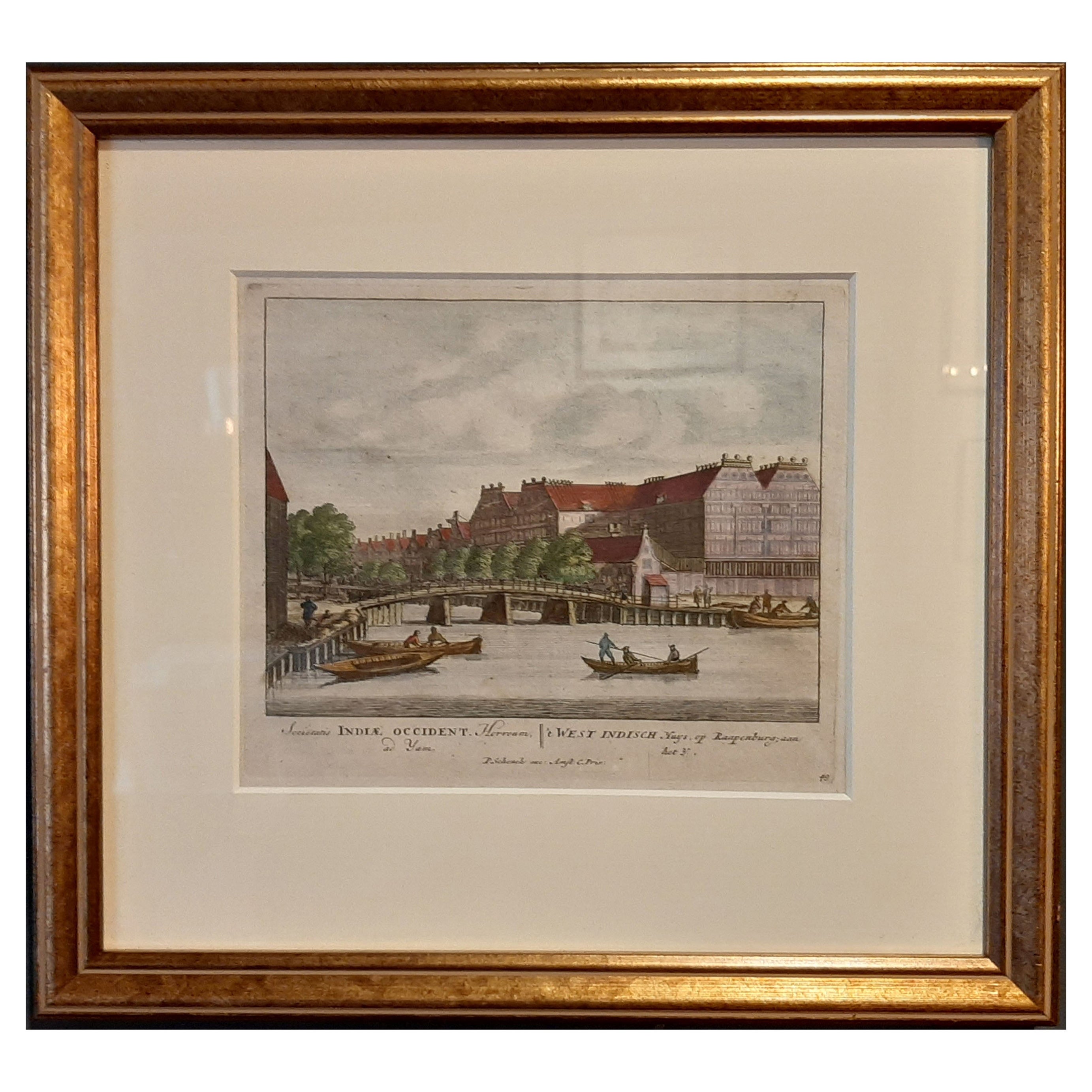
Framed View of the Brouwersgracht in Amsterdam, the Netherlands, 1708
Located in Langweer, NL
Antique print titled 'Societatis Indiae Occident (..) - West Indisch Huys op Raapenburg (..)'.
Despite the title suggesting this print is a view of the West-Indisch House in Amst...
Category
Antique Early 1700s Maps
Materials
Paper

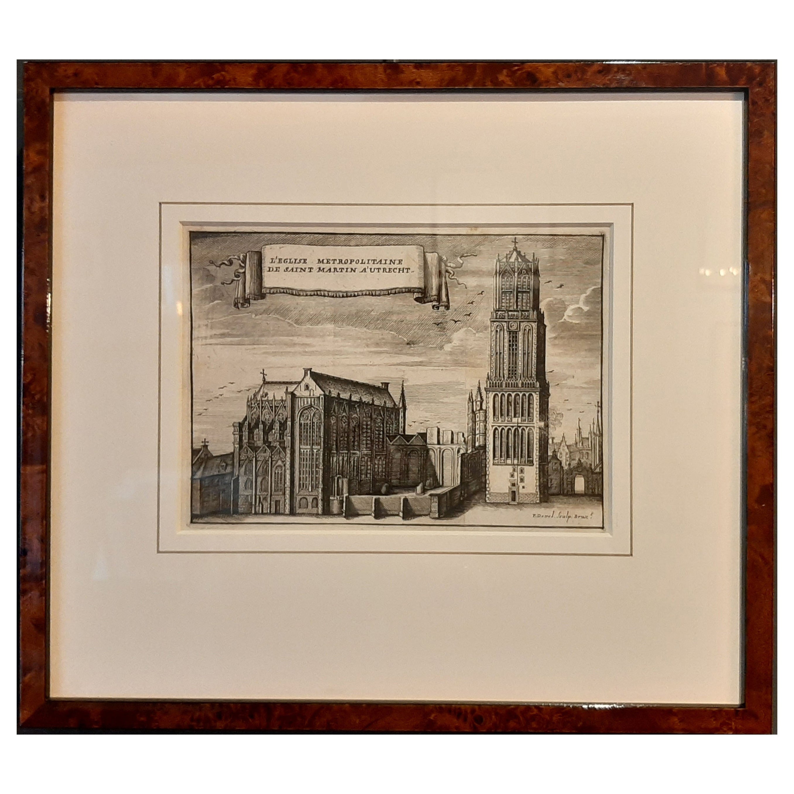
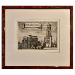
Framed View of St. Martin's Cathedral or Domkerk, Utrecht, The Netherlands, 1770
Located in Langweer, NL
Antique print titled 'L'Eglise Metropolitaine de Saint Martin a' Utrecht'.
View of St. Martin's Cathedral in Utrecht, also known as 'Domkerk'.
Artists and Engravers: Publishe...
Category
Antique 1770s Prints
Materials
Paper
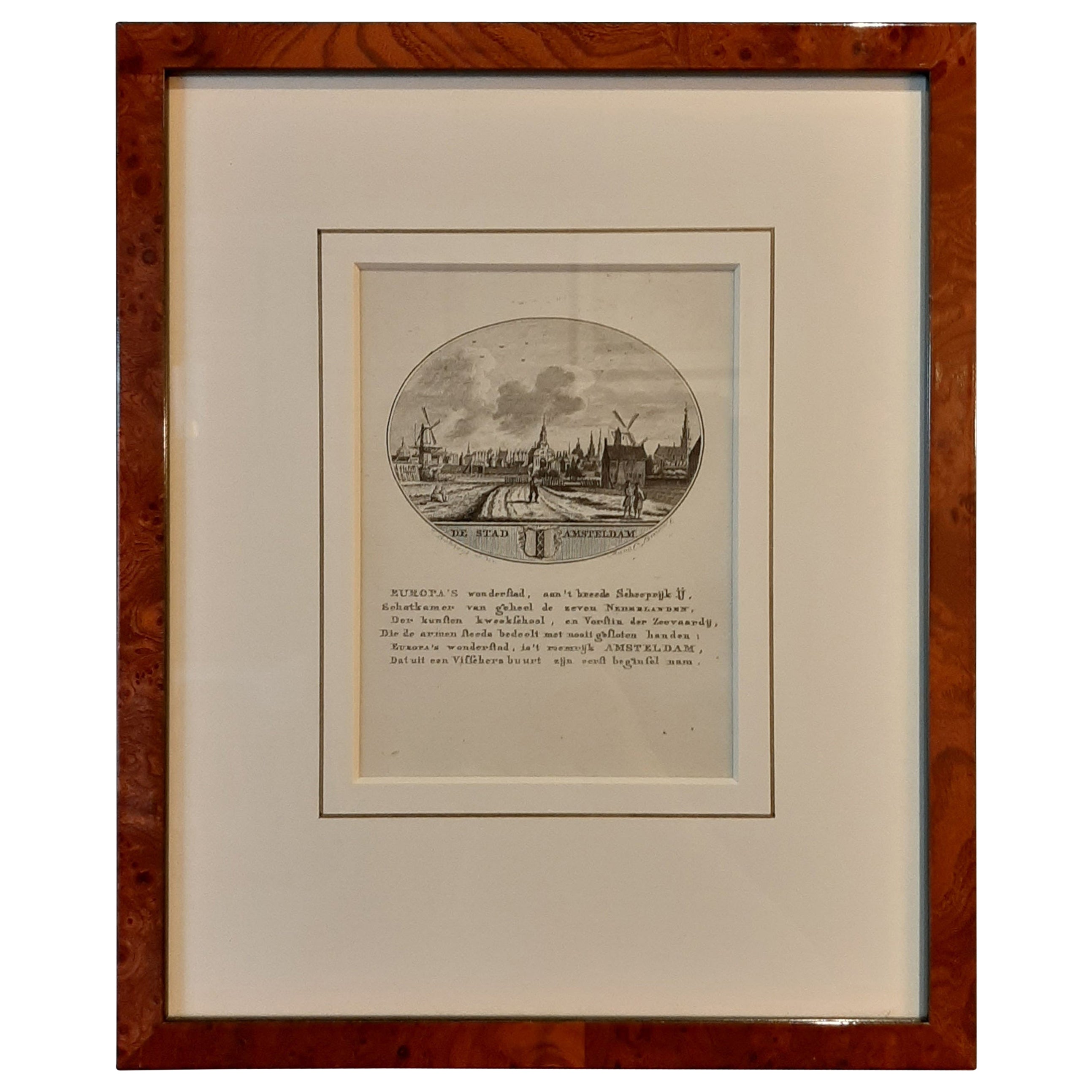
Nicely Framed View on the 'Spaarndammerdijk' in Amsterdam, the Netherlands, 1795
Located in Langweer, NL
Antique print titled 'De Stad Amsteldam'.
View on the 'Spaarndammerdijk' in the city of Amsterdam, the Netherlands. This print originates from 'De...
Category
Antique 1790s Prints
Materials
Paper
You May Also Like
N.E. View of the United States Capitol, Washington, DC Antique Proof Print 1858
Located in Colorado Springs, CO
This engraved print shows a view of the United States Capitol Building, in Washington, D.C. The print depicts the neoclassical building from the northeast orientation, with a bustling street scene in front. The steel engraving is a proof printing, drawn and engraved by Henry Sartain and published in 1858.
Plans began in May 1854 to build a new cast-iron dome for the United States Capitol. The then-architect of the Capitol Thomas Walter and his team were sold on the aesthetics of a new dome, as well as the utility of a fire-proof one. A year later, on March 3, 1855, President Franklin Pierce...
Category
Antique 1850s American Prints
Materials
Paper

City View of Nuremberg, Germany: An 18th Century Hand-Colored Map by M. Seutter
By Matthew Seutter
Located in Alamo, CA
An 18th century hand-colored city view of Nuremburg, Germany entitled "Geometrischer Grundris der des Heiligen Römischen Reichs Freyen Stadt Nürnberg" by Matthaus Seutter from his "A...
Category
Antique Mid-18th Century German Maps
Materials
Paper

Hand-Colored 18th Century Homann Map of the Danube, Italy, Greece, Croatia
By Johann Baptist Homann
Located in Alamo, CA
"Fluviorum in Europa principis Danubii" is a hand colored map of the region about the Danube river created by Johann Baptist Homann (1663-1724) in his 'Atlas Novus Terrarum', publish...
Category
Antique Early 18th Century German Maps
Materials
Paper

South America: Hand-colored 18th Century Framed Map by Thomas Jefferys
By Thomas Jefferys
Located in Alamo, CA
This detailed hand-colored map of South America by Thomas Jefferys was published in London in 1750. The map shows countries, early colonial possessions, towns, rivers, mountains, and...
Category
Antique Mid-18th Century English Maps
Materials
Paper

17th Century Hand Colored Map of the Liege Region in Belgium by Visscher
By Nicolaes Visscher II
Located in Alamo, CA
An original 17th century map entitled "Leodiensis Episcopatus in omnes Subjacentes Provincias distincté divisusVisscher, Leodiensis Episcopatus" by Nicolaes Visscher II, published in Amsterdam in 1688. The map is centered on Liege, Belgium, includes the area between Antwerp, Turnhout, Roermond, Cologne, Trier and Dinant.
This attractive map is presented in a cream-colored mat measuring 30" wide x 27.5" high. There is a central fold, as issued. There is minimal spotting in the upper margin and a tiny spot in the right lower margin, which are under the mat. The map is otherwise in excellent condition.
The Visscher family were one of the great cartographic families of the 17th century. Begun by Claes Jansz Visscher...
Category
Antique Late 17th Century Dutch Maps
Materials
Paper

Hand Colored 18th Century Homann Map of Austria Including Vienna and the Danube
By Johann Baptist Homann
Located in Alamo, CA
"Archiducatus Austriae inferioris" is a hand colored map of Austria created by Johann Baptist Homann (1663-1724) and published in Nuremberg, Germany in 1728 shortly after his death. ...
Category
Antique Early 18th Century German Maps
Materials
Paper

Recently Viewed
View AllMore Ways To Browse
Brown Leather Breuer
Buckle Couch
Butterfly Lounge Chair
Button Leather Couch
Carved Root Table
Cedar Together
Chaise Lounge Recliners
Chinese Mahogany Table
Chinese Shield
Chinese Wood And Glass Table
Cityscape Table
Coffee Table Nest
Color Screen Room Divider
Crucial Trading
Curved Bar Cart
Delft Chargers
Delft Tiles Furniture
Delft Tiles