Items Similar to Old Engraving of the Trarbach Battle in Rhineland-Palatinate, Germany, c.1710


Want more images or videos?
Request additional images or videos from the seller
1 of 5
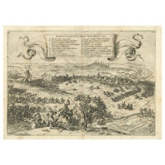
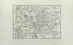
Old Engraving of the Trarbach Battle in Rhineland-Palatinate, Germany, c.1710
$264.58
$330.7320% Off
£198.80
£248.4920% Off
€224
€28020% Off
CA$364.33
CA$455.4220% Off
A$407.76
A$509.7020% Off
CHF 213.45
CHF 266.8120% Off
MX$4,953.50
MX$6,191.8720% Off
NOK 2,710.22
NOK 3,387.7720% Off
SEK 2,557.56
SEK 3,196.9420% Off
DKK 1,704.86
DKK 2,131.0820% Off
About the Item
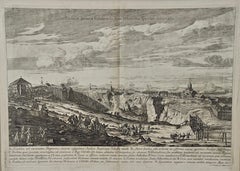
Rare antique print titled 'Plan de la Ville et Chateau Traarbach (..)'. Battle plan of Trarbach, Rhineland-Palatinate, Germany.
Published circa 1710 by P. Schenk.
Below image text in Dutch and Latin, describing the victory over the strongly build Castle of Traerbach, of the allied forces under command of the Prince of Hessen after heavy bombing. Traerbach and a number of others castles along the river Moselle fell to the allied forces whereby the famous Baron de Trogne lost his life.
Background of this battle:
The Battle of Blenheim, 1704
The Battle of Blenheim fought on August 13, 1704 was one of the turning points of the War of the Spanish Succession (1701-14), saving Vienna from the Franco-Bavarian army and preventing the collapse of the Grand Alliance.
To bring the war to a swift end, Louis XIV of France planned to seize the Emperor Leopold’s capital and knock Austria out of the war. The French armies and those of its Bavarian allies, together with a revolt in Austrian-controlled Hungary, threatened Vienna from several sides. Realising the danger, the Duke of Marlborough marched his forces 250 miles from the Low Countries to the River Danube in just five weeks, brilliantly keeping his destination a secret from both friend and foe. At the village of Blindheim (Blenheim), Marlborough and Prince Eugene of Savoy engaged the French and Bavarian forces and scored an overwhelming victory. Bavaria was knocked out of the war, and Louis’s hopes for a quick victory came to an end. France suffered more than 30,000 casualties, including the commander-in-chief, Marshal Tallard, who was taken captive to England. By the end of the year, the Alliance had taken Landau, Trier and Trarbach and stood poised to take the war into France itself.
The role of Meredith’s Own at Blenheim is not entirely clear, nor are the regiment’s casualties. However, the ‘Blenheim Roll’ does name the 32 officers entitled to share in the £65,000 bounty given by Queen Anne after the battle. Of these, the Colonel received £72, Lieutenant Colonels £51, Majors £45, Captains £20, Lieutenants and Quartermasters £14, Surgeons £12, Ensigns £11 and the Surgeon’s Mate £7 10s 0d. Further down the ranks, the regiment’s 29 sergeants were each entitled to £2 and the 34 Corporals and 480 privates and drummers to 30 shillings and £1 respectively.
Blenheim was, in fact, the second battle which Meredith’s Own fought. Their baptism of fire had come few weeks earlier in the Alliance victory at the Battle of the Schellenburg in Bavaria. The regiment lost four officers killed and 19 wounded, including Meredith himself. (source: Royal Hampshire Regiment site)
Condition: Fair, strong toning. Shows wear, blank verso. Please study image carefully.
- Dimensions:Height: 7.88 in (20 cm)Width: 9.45 in (24 cm)Depth: 0 in (0.02 mm)
- Materials and Techniques:
- Period:1710-1719
- Date of Manufacture:circa 1710
- Condition:
- Seller Location:Langweer, NL
- Reference Number:Seller: BG-13009-1131stDibs: LU3054326563402
About the Seller
5.0
Recognized Seller
These prestigious sellers are industry leaders and represent the highest echelon for item quality and design.
Platinum Seller
Premium sellers with a 4.7+ rating and 24-hour response times
Established in 2009
1stDibs seller since 2017
2,535 sales on 1stDibs
Typical response time: <1 hour
- ShippingRetrieving quote...Shipping from: Langweer, Netherlands
- Return Policy
Authenticity Guarantee
In the unlikely event there’s an issue with an item’s authenticity, contact us within 1 year for a full refund. DetailsMoney-Back Guarantee
If your item is not as described, is damaged in transit, or does not arrive, contact us within 7 days for a full refund. Details24-Hour Cancellation
You have a 24-hour grace period in which to reconsider your purchase, with no questions asked.Vetted Professional Sellers
Our world-class sellers must adhere to strict standards for service and quality, maintaining the integrity of our listings.Price-Match Guarantee
If you find that a seller listed the same item for a lower price elsewhere, we’ll match it.Trusted Global Delivery
Our best-in-class carrier network provides specialized shipping options worldwide, including custom delivery.More From This Seller
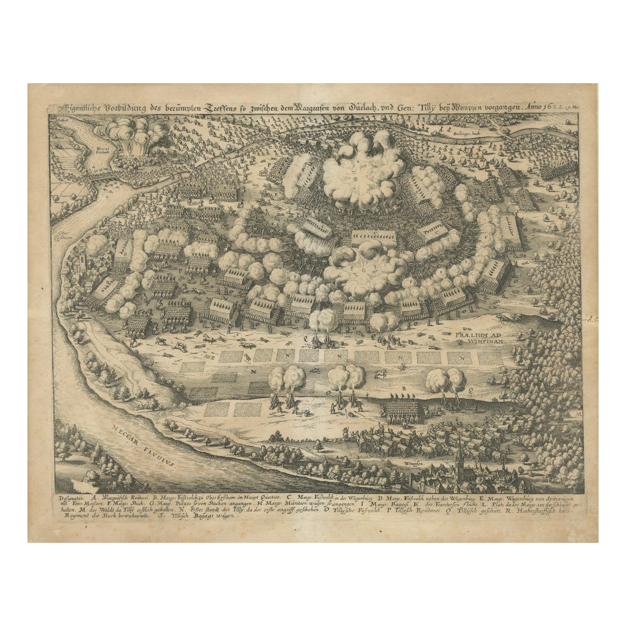
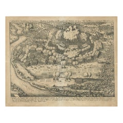
View AllBattle of Wimpfen, 1622: Engraving by Matthäus Merian (ca. 1645)
Located in Langweer, NL
Title: Battle of Wimpfen, 1622: Engraving by Matthäus Merian (ca. 1645)
Description: This antique copper engraving, created by the renowned Swiss-German engraver Matthäus Merian aro...
Category
Antique 1640s Maps
Materials
Paper
$321 Sale Price
20% Off
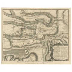
Antique Print of the Battle of Oudenard by I. Basire, 1751
Located in Langweer, NL
Plan of the Battle of Oudenard, fought during the war of the Spanish Succession (1701-1714), in which the Allies, led by Marlborough and Prince Eugene of Savoy, beat the French under the leadership of Louis Joseph, duc de Vendôme, and Louis, duc de Bourgogne (later the Dauphin, but died of measles at 29). The French commanders had quarrelled, resulting in a divided force that was easily beaten. Nicholas Tindal (1687-1774), at one time Chaplain to Greenwich Hospital...
Category
Antique Mid-18th Century Prints
Materials
Paper
$226 Sale Price
20% Off
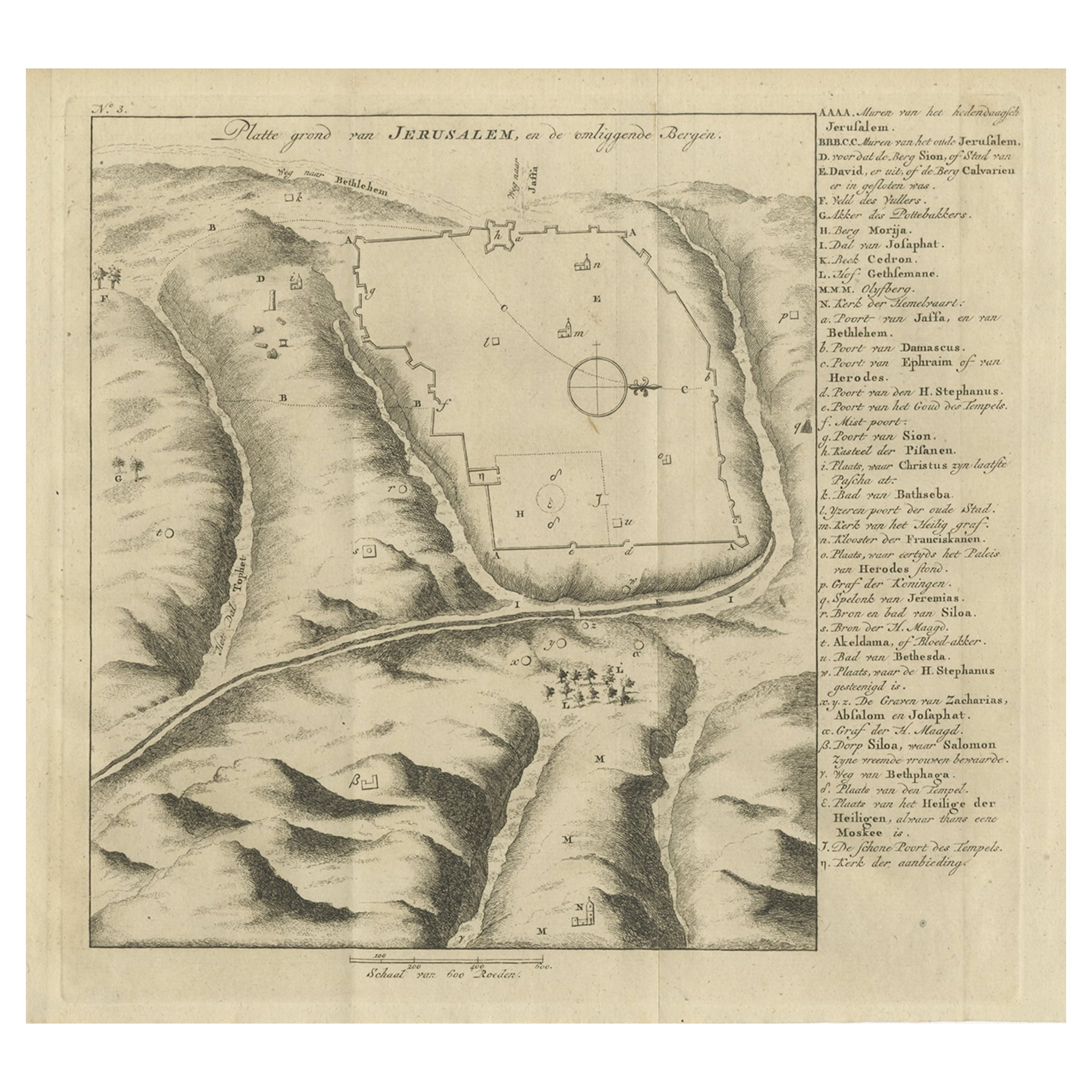
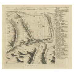
Antique Engraving of a Map or Plan of Jerusalem and Surrounding Mountains, 1773
Located in Langweer, NL
Antique map titled 'Platte grond van Jerusalem, en de omliggende Bergen'. Plan of the city of Jerusalem, with surrounding mountains. Originates from the first Dutch editon of an inte...
Category
Antique 18th Century Maps
Materials
Paper
$255 Sale Price
20% Off
Old Engraving of The Battle of Bergen in Hainaut during the Eighty Years', 1632
Located in Langweer, NL
The print is a historical depiction of the Siege of Bergen (also known as Mons) in Hainaut in 1572, during the Eighty Years' War.
This event is significant as it involved Count Lou...
Category
Antique 1640s Prints
Materials
Paper
$793 Sale Price
20% Off
Free Shipping
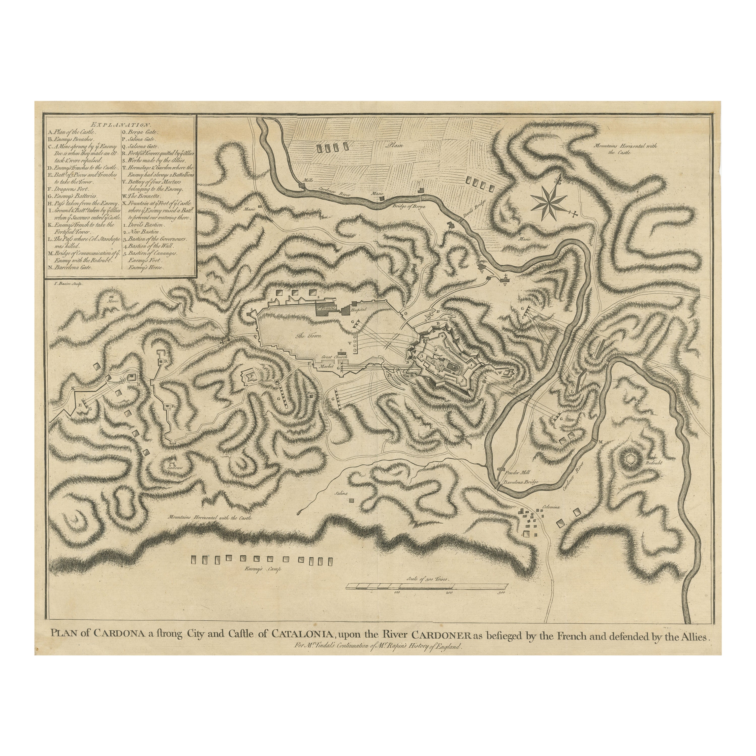
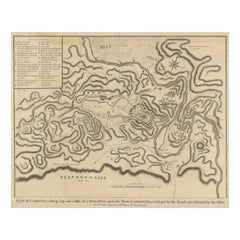
Antique Plan of the Siege of the Castle of Cardona in 1714
Located in Langweer, NL
Antique print titled 'Plan of Cardona a strong city and castle of Catalonia, upon the river Cardoner as besieged by the French and defended by the Allies'. A plan of the siege of the...
Category
Antique Mid-18th Century Prints
Materials
Paper
$321 Sale Price
20% Off
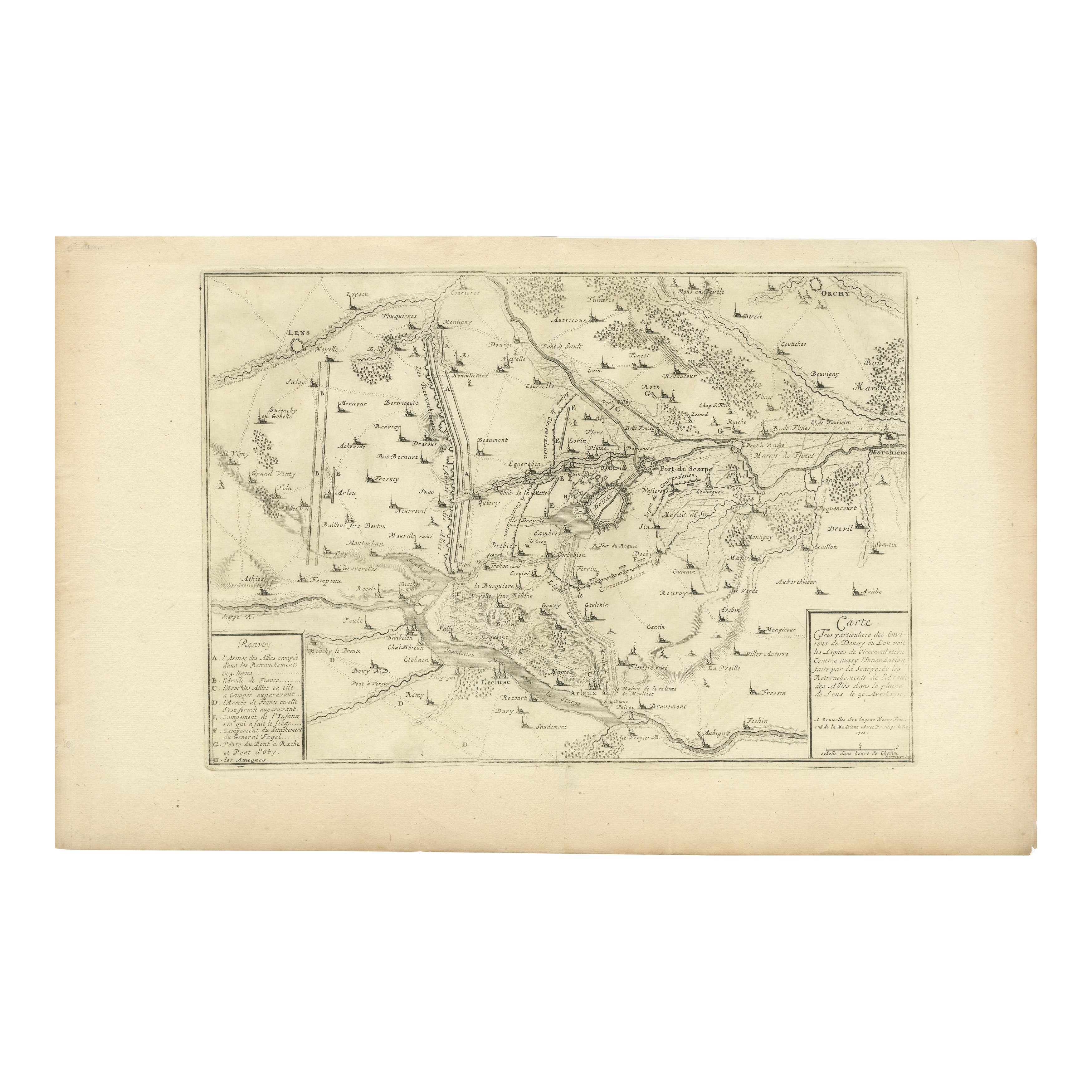
Detailed 1720s Map – Siege of Douay and Lines of Circumvallation, France
Located in Langweer, NL
Detailed 1720s Map – Siege of Douay and Lines of Circumvallation, France
This engraved map shows the detailed fortifications and surrounding region of Douay (Douai) in northern Fran...
Category
Antique Early 18th Century French Maps
Materials
Paper
You May Also Like
17th-18th Century Siege of Graves Mapping Engraving By Willian III
Located in Kingston, NY
RARE French 17th-18th Century Enhanced Siege of Graves Mapping Engraving BY William III, also widely known as William of Orange,
The Siege of Grave in Dutch Brabant started by Monsie...
Category
Antique 17th Century French Prints
Materials
Paper

Map of Battle of Smolensk - Etching by Pierre François Tardieu - 1837
Located in Roma, IT
Map of Battle of Smolensk is an Etching realized by Pierre François Tardieu in 1837.
Good conditions.
The artwork is realized in a well-balanced composition. the artwork and belong...
Category
1830s Modern Figurative Prints
Materials
Lithograph
17th Century Toulouse, Savve, Sommieres Topographical Map by Iohan Peeters
Located in New York, NY
Fine topographical 17th century map of Toulouse, Savve and Sommieres by Iohan Peeters
Beautiful engraving of the capital of France's Occitanie Region, Toulouse, called La Ville Rose- the Pink City, for the terracotta bricks used in its many buildings, giving the city a distinct apricot-rose hue. An important cultural and educational center, the city's residents included Nobel Prize winners and world renown artists- Henri de Toulouse-Lautrec, Henri Martin, Jean-Auguste-Dominique Ingres, Antonin Mercie, Alexandre Falguiere and more recently Cyril Kongo...
Category
Antique 17th Century Dutch Maps
Materials
Paper

Battle of Austerlitz - Etching by Pierre François Tardieu - 1837
Located in Roma, IT
Battle of Austerlitz is an Etching realized by Pierre François Tardieu in 1837.
Good conditions.
The artwork is realized in a well-balanced composition. the artwork and belongs to ...
Category
1830s Modern Figurative Prints
Materials
Lithograph
1657 Janssonius Map of Vermandois and Cappelle, Ric. A-004
Located in Norton, MA
1657 Janssonius map of
Vermandois and Cappelle
Ric.a004
Description: Antique map of France titled 'Descriptio Veromanduorum - Gouvernement de la Cappelle'. Two detailed maps o...
Category
Antique 17th Century Unknown Maps
Materials
Paper

An Antique Engraved View of Copper Mining in Sweden in the 17th C. by Dahlberg
By Erik Dahlberg
Located in Alamo, CA
This is an antique engraved view entitled "Fodinae aerariae Falunenfis, qui orientem fpectat, delineatio" (Copper mining in Falun), Sweden in 1705 from "Sueciae Antiquae et Hodiernae"' published in Stockholm by Erik Dahlberg (1625-1703). The engraving was created by Johannes van den Aveelen (1650-1727), who was an accomplished copperplate engraver who emigrated to Sweden to work on Dahlberg's spectacular book, "Sueciae Antiquae et Hodiernae", which was focused on the views and architecture of Sweden, both in the ancient past and at the time of the publication.
This engraving depicts a very active 17th century working scene...
Category
Early 18th Century Naturalistic Landscape Prints
Materials
Laid Paper, Engraving