Original Antique City Plan of Delhi, India, 1861
View Similar Items


Want more images or videos?
Request additional images or videos from the seller
1 of 5
Auction endedBrowse Current Auctions
Original Antique City Plan of Delhi, India, 1861
About the Item
- Dimensions:Height: 13 in (33.02 cm)Width: 19 in (48.26 cm)Depth: 0.07 in (1.78 mm)
- Style:Victorian (Of the Period)
- Materials and Techniques:Paper,Other
- Place of Origin:
- Period:
- Date of Manufacture:1861
- Condition:Wear consistent with age and use.
- Seller Location:St Annes, GB
- Reference Number:1stDibs: LU1836324414722
About the Seller
4.9
Platinum Seller
These expertly vetted sellers are 1stDibs' most experienced sellers and are rated highest by our customers.
1stDibs seller since 2016
2,565 sales on 1stDibs
Associations
International Confederation of Art and Antique Dealers' Associations
More From This SellerView All
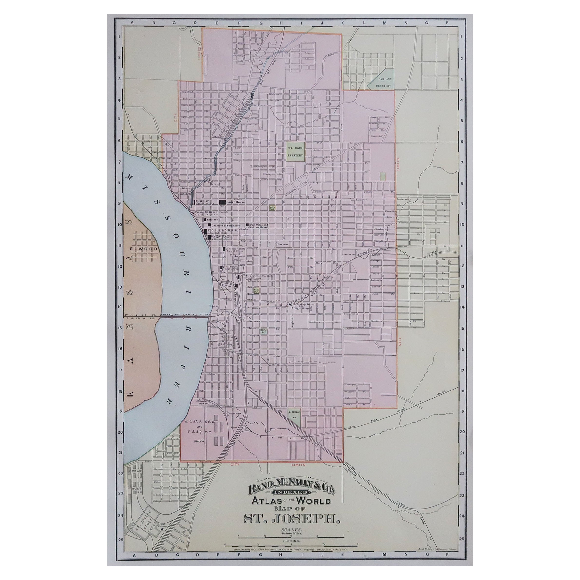
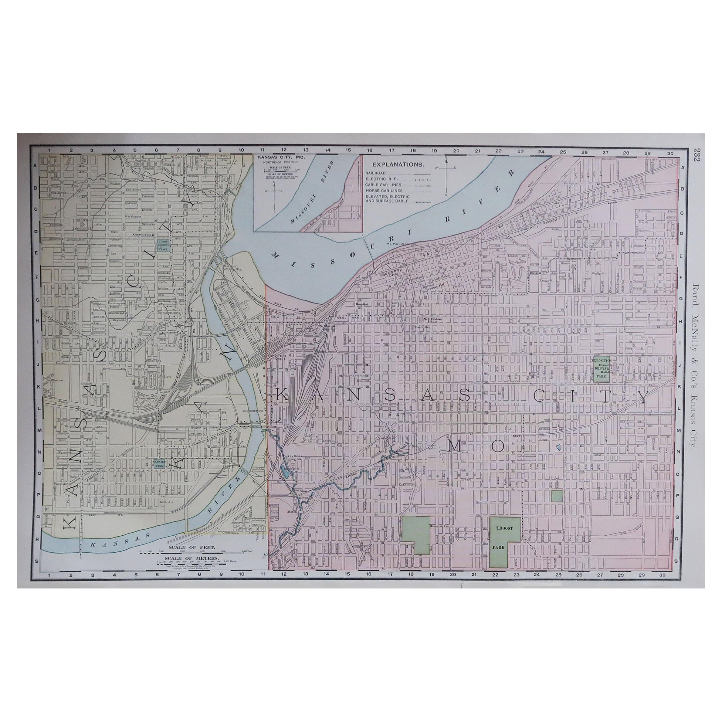
- Original Antique City Plan of Kansas City, USA. 1894By Rand McNally & Co.Located in St Annes, LancashireFabulous colorful map of Kansas City Original color By Rand, McNally & Co. Published, 1894 Unframed Slightly reduced bottom margin. Free shipping.Category
Antique 1890s American Maps
MaterialsPaper

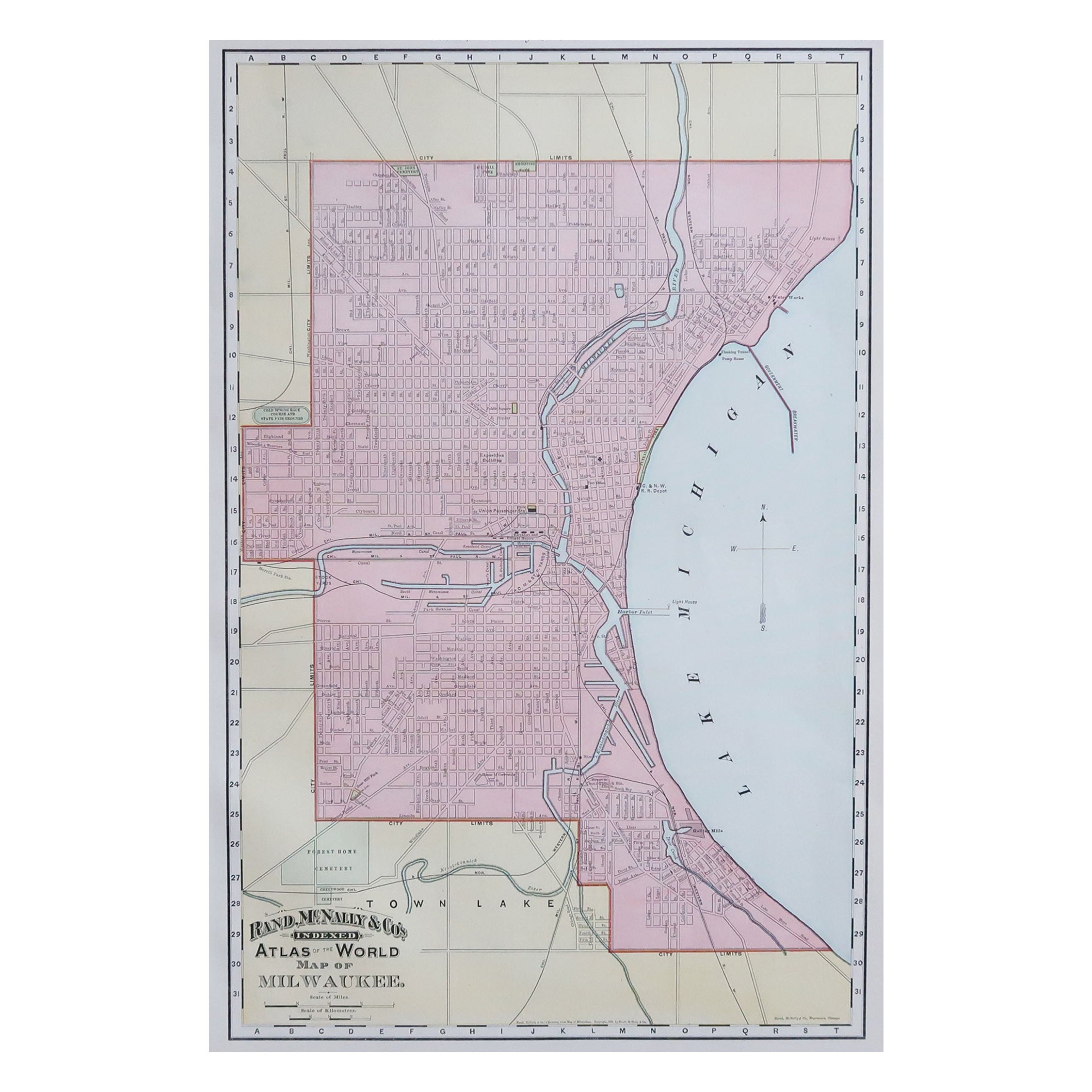
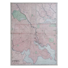
- Original Antique City Plan of Milwaukee, USA, 1894By Rand McNally & Co.Located in St Annes, LancashireFabulous colorful map of Milwaukee Original color By Rand, McNally & Co. Published, 1894 Unframed Free shipping.Category
Antique 1890s American Maps
MaterialsPaper

- Original Antique Map of Indonesia, 1861Located in St Annes, LancashireGreat map of Indonesia Drawn and engraved by Edward Weller Original color Published in The Weekly Dispatch Atlas, 1861 Repairs to minor e...Category
Antique 1860s English Victorian Maps
MaterialsPaper

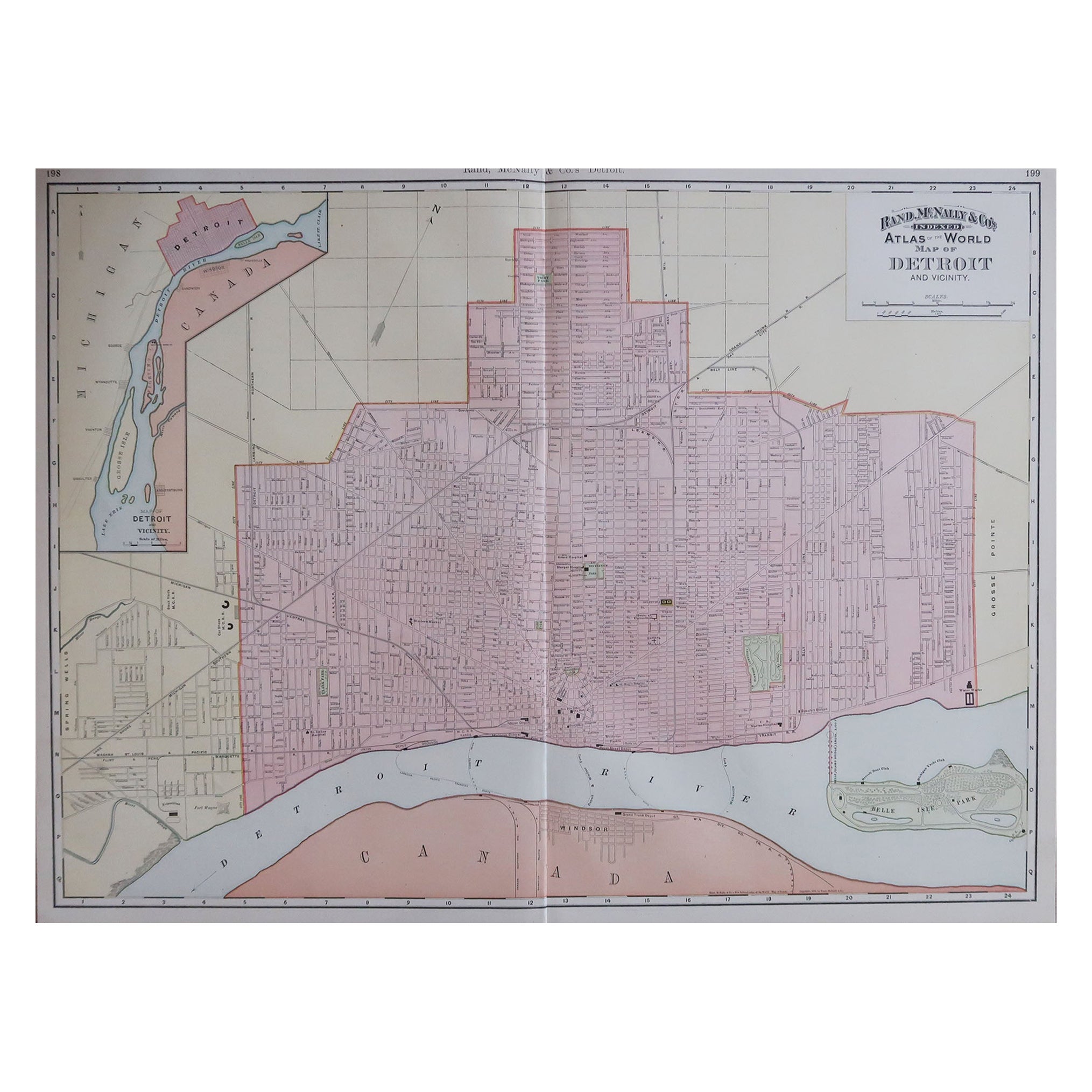
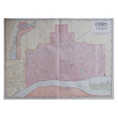
- Large Original Antique City Plan of Detroit, USA, 1894By Rand McNally & Co.Located in St Annes, LancashireFabulous colorful map of Detroit Original color By Rand, McNally & Co. Published, 1894 Unframed Free shipping.Category
Antique 1890s American Maps
MaterialsPaper
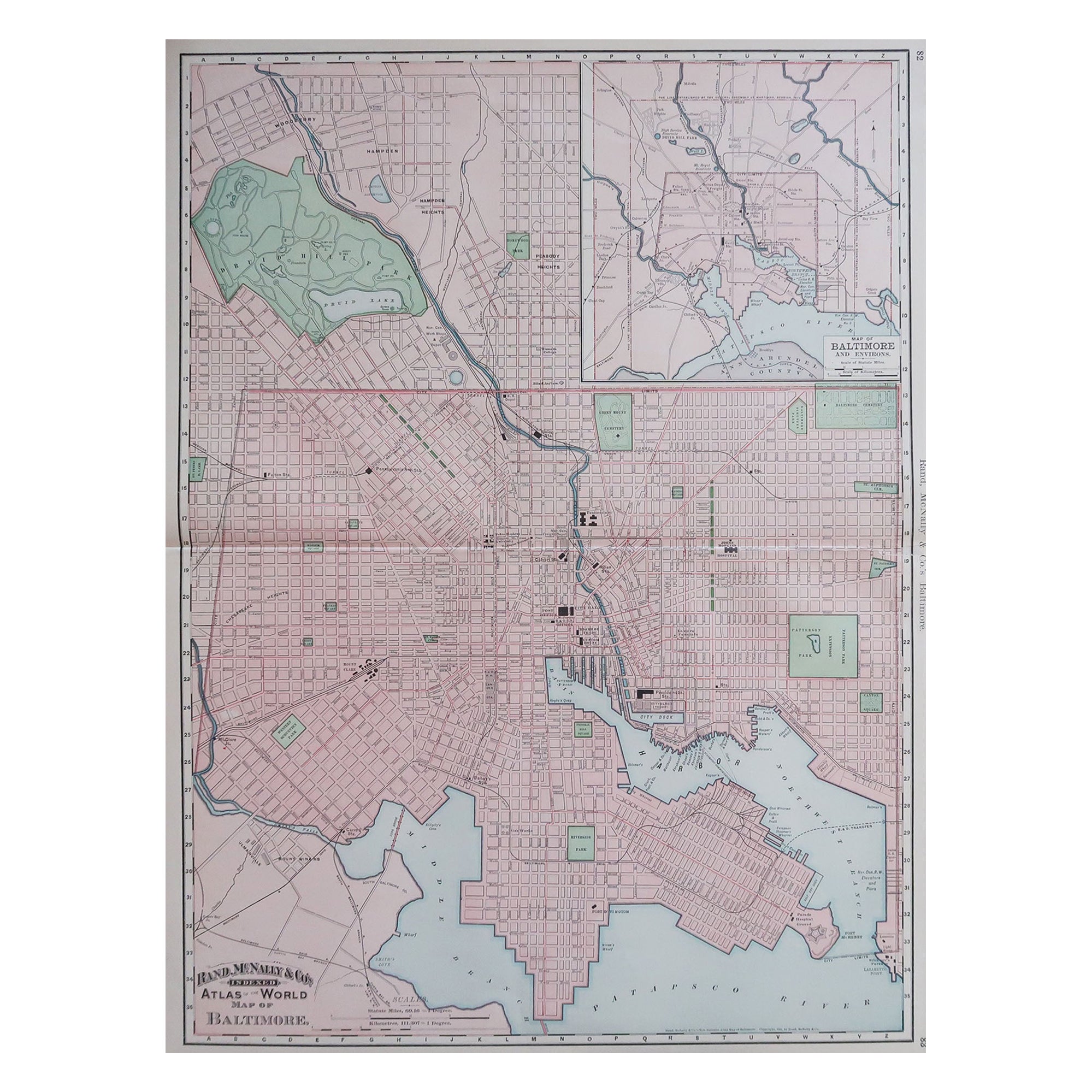
- Large Original Antique City Plan of Baltimore, USA, 1894By Rand McNally & Co.Located in St Annes, LancashireFabulous colorful map of Baltimore Original color By Rand, McNally & Co. Published, 1894 Unframed Free shipping.Category
Antique 1890s American Maps
MaterialsPaper
- Large Original Antique City Plan of Montreal, Canada, circa 1900By Rand McNally & Co.Located in St Annes, LancashireFabulous colorful map of Montreal Original color By Rand, McNally & Co. Published, circa 1900 Unframed Free shipping.Category
Antique Early 1900s American Maps
MaterialsPaper

You May Also Like
- Antique Plan of the City of Calcutta 'India' by Letts, 1883Located in Langweer, NLBeautiful colored plan showing buildings (with key), Fort William, race ground, canals, railroads, etc. This plan originates from Letts's Popular Atlas.Category
Antique Late 19th Century Maps
MaterialsPaper
 $274 Sale Price33% Off
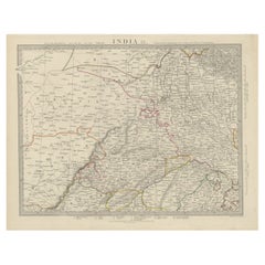
 - Antique Map of the Region of Delhi in India, 1833Located in Langweer, NLAntique map titled 'India IX'. Old steel engraved map of the region of Delhi, with great detail. Artists and Engravers: Engraved by J. & C. Walker. Published under the superinten...Category
Antique 19th Century Maps
MaterialsPaper
- Antique City View and Map of IJlst, City in Friesland, Holland, Framed, 1664Located in Langweer, NLAntique map titled 'Ylst'. Old map and city view of the city of IJlst, Friesland. This map originates from 'Beschrijvinge van de Heerlyckheydt van Frieslandt' by B. Schotanus à Sterr...Category
Antique 17th Century Maps
MaterialsPaper
 $439 Sale Price20% Off
 - Gold Leaf Foil Pictorial Plan Map of the West Country of England Antique StyleLocated in GBWe are delighted to offer for sale this lovely Antique style pictorial plan map of the West Country of England etched in gold leaf foil This is a very interesting and decorative p...Category
20th Century English Adam Style Maps
MaterialsGold Leaf
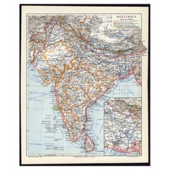
- Antique German Map of India and Sri Lanka or Ceylon, 1902By MeyerLocated in Langweer, NLAntique map titled 'Ostindien.' (Map of India with an inset map of East-Bengal.) This attractive original old antique print / plate / map originates from 1885-1907 editions of a famous German encyclopedia: 'Meyers grosses Konversations-Lexikon.', published in Leipzig and Vienna. Meyers Konversations-Lexikon was a major German encyclopedia that existed in various editions from 1839 until 1984, when it merged with the Brockhaus encyclopedia. Several of the plates were also used in Dutch Encyclopedia's like Winkler Prins...Category
20th Century Maps
MaterialsPaper
 $60 Sale Price20% Off
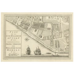
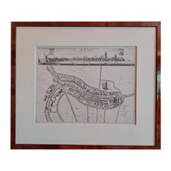
 - Original Antique Plan of the Dutch Settlement at Chinsura-Hooghly, India, 1746Located in Langweer, NLAntique print, titled: 'Plan de la Loge Hollandoise d'Ougly'. A plan of the Dutch settlement at Chinsura-Hooghly, India. This print originates from Prevost's 'Histoire Generale d...Category
Antique 1740s Maps
MaterialsPaper