Items Similar to Original Antique Map of Township Ulrum in Groningen, The Netherlands, 1862

Want more images or videos?
Request additional images or videos from the seller
1 of 6
Original Antique Map of Township Ulrum in Groningen, The Netherlands, 1862
About the Item
Groningen: Gemeente Houwerzijl-Niekerk-Vierhuizen-Ulrum-Zoutkamp. These scarse detailed maps of Dutch Towns originate from the 'Gemeente atlas van de Provincie Groningen in 62 kaarten.' by C. Fehse. This atlas of all towns in Groningen, the Netherlands, was published in 1862 by J. Oomkens.
Artists and Engravers: Author: C. Fehse. This atlas is the only atlas known by C. Fehse. It is assumed that Jacob Kuyper was inspired by this atlas leading to the publication of the "Gemeente Atlas", with 1210 plans of all the towns and villages in the Netherlands.
Condition: Fine. Occasional foxing and light staining. Please study scan carefully.
Date: 1862
We sell original antique maps to collectors, historians, educators and interior decorators all over the world. Our collection includes a wide range of authentic antique maps from the 16th to the 20th centuries. Buying and collecting antique maps is a tradition that goes back hundreds of years. Antique maps have proved a richly rewarding investment over the past decade, thanks to a growing appreciation of their unique historical appeal. Today the decorative qualities of antique maps are widely recognized by interior designers who appreciate their beauty and design flexibility. Depending on the individual map, presentation, and context, a rare or antique map can be modern, traditional, abstract, figurative, serious or whimsical. We offer a wide range of authentic antique maps for any budget.
- Dimensions:Height: 9.65 in (24.5 cm)Width: 7.49 in (19 cm)Depth: 0 in (0.01 mm)
- Materials and Techniques:
- Period:
- Date of Manufacture:1862
- Condition:Good, given age. A few spots in the margins. Original folds as issued. General age-related toning and/or occasional minor defects from handling. Please study image carefully.
- Seller Location:Langweer, NL
- Reference Number:
About the Seller
5.0
Platinum Seller
These expertly vetted sellers are 1stDibs' most experienced sellers and are rated highest by our customers.
Established in 2009
1stDibs seller since 2017
1,922 sales on 1stDibs
Typical response time: <1 hour
- ShippingRetrieving quote...Ships From: Langweer, Netherlands
- Return PolicyA return for this item may be initiated within 14 days of delivery.
More From This SellerView All
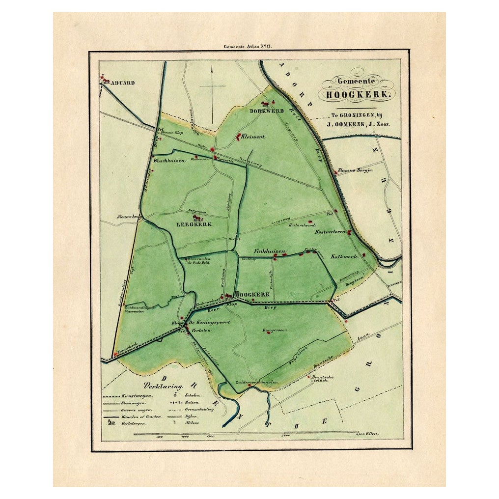
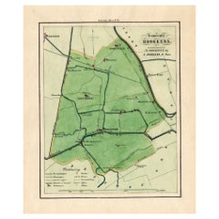
- Antique Map of the Township of Hoogkerk in Groningen, The Netherlands, 1862Located in Langweer, NLGroningen: Gemeente Dorkwerd-Hoogkerk-Leegkerk-Vinkhuizen. These scarse detailed maps of Dutch Towns originate from the 'Gemeente atlas van de Provincie Groningen in 62 kaarten.' by ...Category
Antique 19th Century Maps
MaterialsPaper
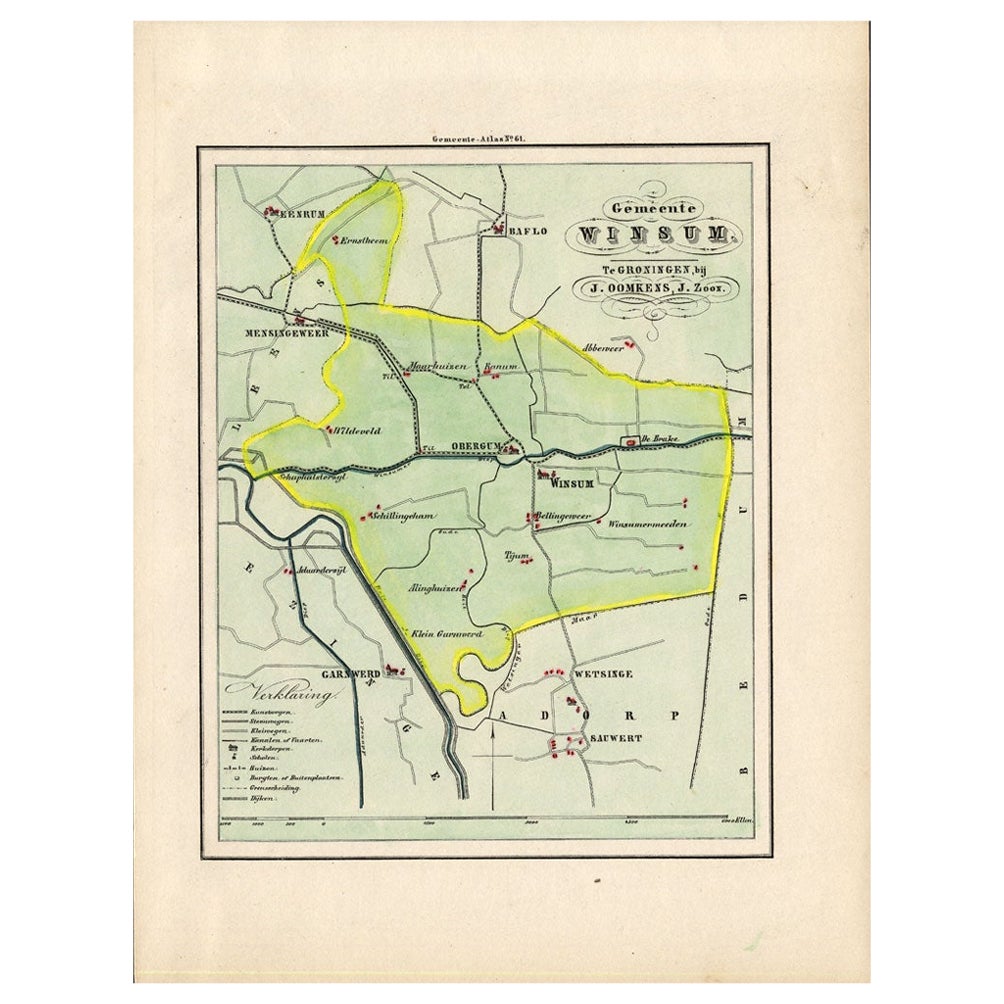
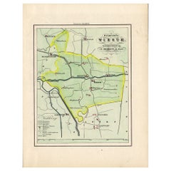
- Antique Map of the Township of Winsum, Groningen in The Netherlands, 1862Located in Langweer, NLGroningen: Gemeente Obergum-Winsum. These scarse detailed maps of Dutch Towns originate from the 'Gemeente atlas van de Provincie Groningen in 62 kaarten.' by C. Fehse. This atlas of...Category
Antique 19th Century Maps
MaterialsPaper
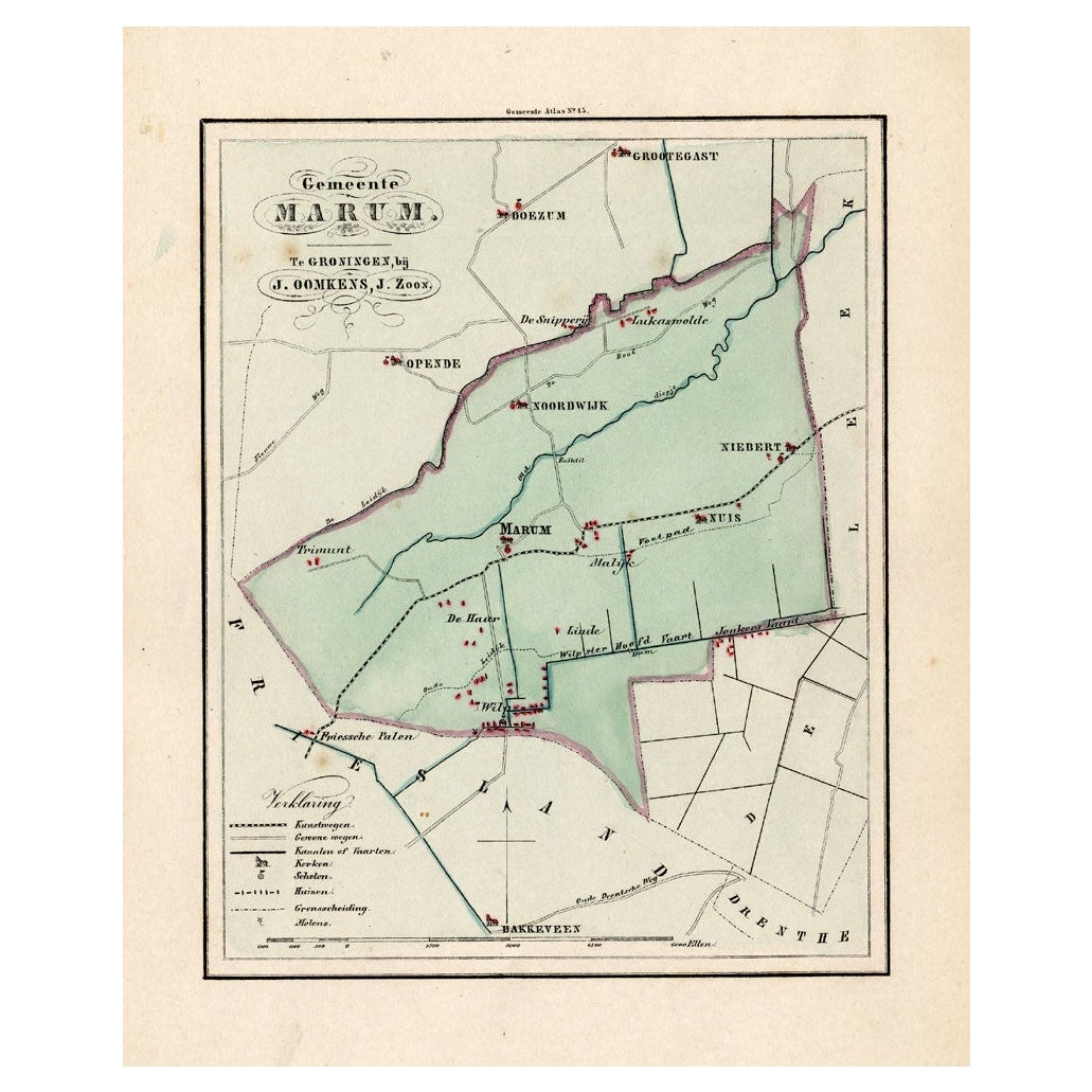
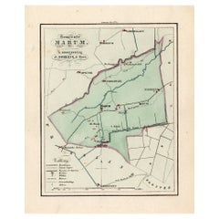
- Antique Map of the Township of Marum in Groningen, The Netherlands, 1862Located in Langweer, NLGroningen: Gemeente Marum-Noordwijk-NuiS. These scarse detailed maps of Dutch Towns originate from the 'Gemeente atlas van de Provincie Groningen in 62 kaarten.' by C. Fehse. This at...Category
Antique 19th Century Maps
MaterialsPaper
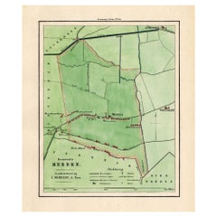
- Antique Map of the Township of Meeden in Groningen, the Netherlands, 1862Located in Langweer, NLGroningen: Gemeente Meeden. These scarse detailed maps of Dutch Towns originate from the 'Gemeente atlas van de Provincie Groningen in 62 kaarten.' by C. Fehse. This atlas of all tow...Category
Antique 19th Century Maps
MaterialsPaper
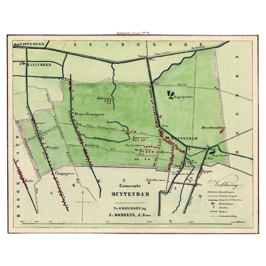
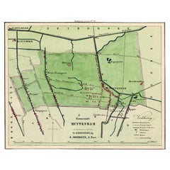
- Antique Map of the Township of Muntendam in Groningen, the Netherlands, 1862Located in Langweer, NLGroningen: Gemeente Muntendam. These scarse detailed maps of Dutch Towns originate from the 'Gemeente atlas van de Provincie Groningen in 62 kaarten.' by C. Fehse. This atlas of all ...Category
Antique 19th Century Maps
MaterialsPaper
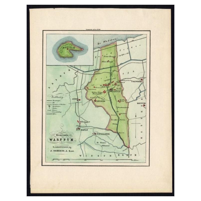
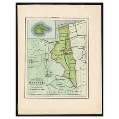
- Original Antique Map of the township of Warffum in The Netherlands, 1862Located in Langweer, NLGroningen: Gemeente Rottumeroog-Warffum. These scarse detailed maps of Dutch Towns originate from the 'Gemeente atlas van de Provincie Groningen in 62 kaarten.' by C. Fehse. This atl...Category
Antique 19th Century Maps
MaterialsPaper
You May Also Like
- Original Antique Map of The Netherlands, Engraved by Barlow, Dated 1807Located in St Annes, LancashireGreat map of Netherlands Copper-plate engraving by Barlow Published by Brightly & Kinnersly, Bungay, Suffolk. Dated 1807 Unframed.Category
Antique Early 1800s English Maps
MaterialsPaper
- Original Antique Map of The Netherlands, Sherwood, Neely & Jones, Dated 1809Located in St Annes, LancashireGreat map of The Netherlands Copper-plate engraving by Cooper Published by Sherwood, Neely & Jones. Dated 1809 Unframed.Category
Antique Early 1800s English Maps
MaterialsPaper
- Large Original Antique Map of The World, Fullarton, C.1870Located in St Annes, LancashireGreat map of the World. Showing both hemispheres From the celebrated Royal Illustrated Atlas Lithograph. Original color. Published by Fullarton, Edinburgh, C.1870 Unframed. Rep...Category
Antique 1870s Scottish Maps
MaterialsPaper
- Original Antique Map of the American State of Washington, 1889Located in St Annes, LancashireGreat map of Washington Drawn and Engraved by W. & A.K. Johnston Published By A & C Black, Edinburgh. Original colour Unframed.Category
Antique 1880s Scottish Victorian Maps
MaterialsPaper
- Original Antique Map of the American State of Pennsylvania, 1889Located in St Annes, LancashireGreat map of Pennsylvania Drawn and Engraved by W. & A.K. Johnston Published By A & C Black, Edinburgh. Original colour Unframed. Repair to a minor tear on bottom edge.Category
Antique 1880s Scottish Victorian Maps
MaterialsPaper
- Original Antique Map of the American State of Nevada, 1889Located in St Annes, LancashireGreat map of Nevada Drawn and Engraved by W. & A.K. Johnston Published By A & C Black, Edinburgh. Original colour Unframed.Category
Antique 1880s Scottish Victorian Maps
MaterialsPaper


Recently Viewed
View AllMore Ways To Browse
Hemisphere L
World Map The World
Masque Theatre No
Radnor Furniture
Map Measure
Antique Maps Of British Isles
Taiwan Map
Antique Maps Of Ukraine
Ukraine Antique Map
Antique Map Nova Scotia
Gambia Antique Map
Antique Arizona Map
Antique Maps Of Kansas
Authentic Pirate
Antique Cuba Map
Babylon Map
Montenegro Antique Map
Antique Map Dordogne