Items Similar to Original Map of The Northern Arabian Peninsula, Palestine, Iraq & Iran, 1732


Want more images or videos?
Request additional images or videos from the seller
1 of 5
Original Map of The Northern Arabian Peninsula, Palestine, Iraq & Iran, 1732
About the Item
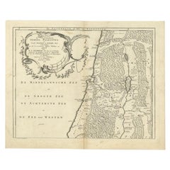
Antique map titled 'Nieuwe kaart van Irak Arabi, Kurdistan, Diarbek (..).'
Detailed map including the northern part of the Arabian peninsula, Palestine, Iraq, Iran and the eastern part of Cyprus. Source unknown, to be determined.
Artists and Engravers: Made by 'Isaak Tirion' after an anonymous artist. Isaak Tirion, a Dutch publisher in Amsterdam, was born 1705. He produced serveral Atlases and Dutch town plans. The maps mainly based on those of Guillaume de l'Isle. He died in 1765. Tirion was born in Utrecht in 1705. He moved to Amsterdam in 1725 and set up shop on Damrak as a book publisher. Tirion quick rose in prominence by publishing pamphlets, historical works, and, most importantly, maps and atlases. He eventually relocated his printing house to the prestigious Kalverstraat. In his long career he produced eight atlases in multiple editions, some of which were published posthumously until about 1784. Most of his cartographic work is based on the earlier maps of Guillaume de L'Isle.
- Dimensions:Height: 11.66 in (29.6 cm)Width: 14.69 in (37.3 cm)Depth: 0.01 in (0.2 mm)
- Materials and Techniques:
- Period:1730-1739
- Date of Manufacture:1732
- Condition:Condition: Good, given age. A few minor crinkles. Original folds as issued. General age-related toning and/or occasional minor defects from handling. Top left margin cut short. Please study image carefully.
- Seller Location:Langweer, NL
- Reference Number:
About the Seller
5.0
Platinum Seller
These expertly vetted sellers are 1stDibs' most experienced sellers and are rated highest by our customers.
Established in 2009
1stDibs seller since 2017
1,916 sales on 1stDibs
Typical response time: <1 hour
- ShippingRetrieving quote...Ships From: Langweer, Netherlands
- Return PolicyA return for this item may be initiated within 14 days of delivery.
More From This SellerView All
- Antique Map of the Arabian Peninsula by Bonne 'c.1780'Located in Langweer, NLAntique map titled 'Carte de l'Arabie, du Golfe Persique, et de la Mer Rouge (..)'. Original antique map of the Arabian Peninsula, including the horn...Category
Antique Late 18th Century Maps
MaterialsPaper
- Antique Map of the Arabian Peninsula by Bonne 'c.1780'Located in Langweer, NLAntique map titled 'Carte de l'Arabie, du Golfe Persique, et de la Mer Rouge (..)'. Original antique map of the Arabian Peninsula, including the horn...Category
Antique Late 18th Century Maps
MaterialsPaper
- Antique Map of the Arabian Peninsula by Franceschini, '1739'Located in Langweer, NLAntique map titled 'Conventus et Residentiae'. Rare map of the Arabian Peninsula. This map originates from 'Provinciarum et Conventum Fratrum Discalc...Category
Antique Mid-18th Century Maps
MaterialsPaper
- Antique Map of the Arabian Peninsula by Bellin 'c.1740'Located in Langweer, NLAntique map titled 'Carte de la Coste d'Arabie, Mer Rouge et Golfe de Perse'. Original antique map of the Arabian Peninsula, labes both Mecca and Med...Category
Antique Mid-18th Century Maps
MaterialsPaper
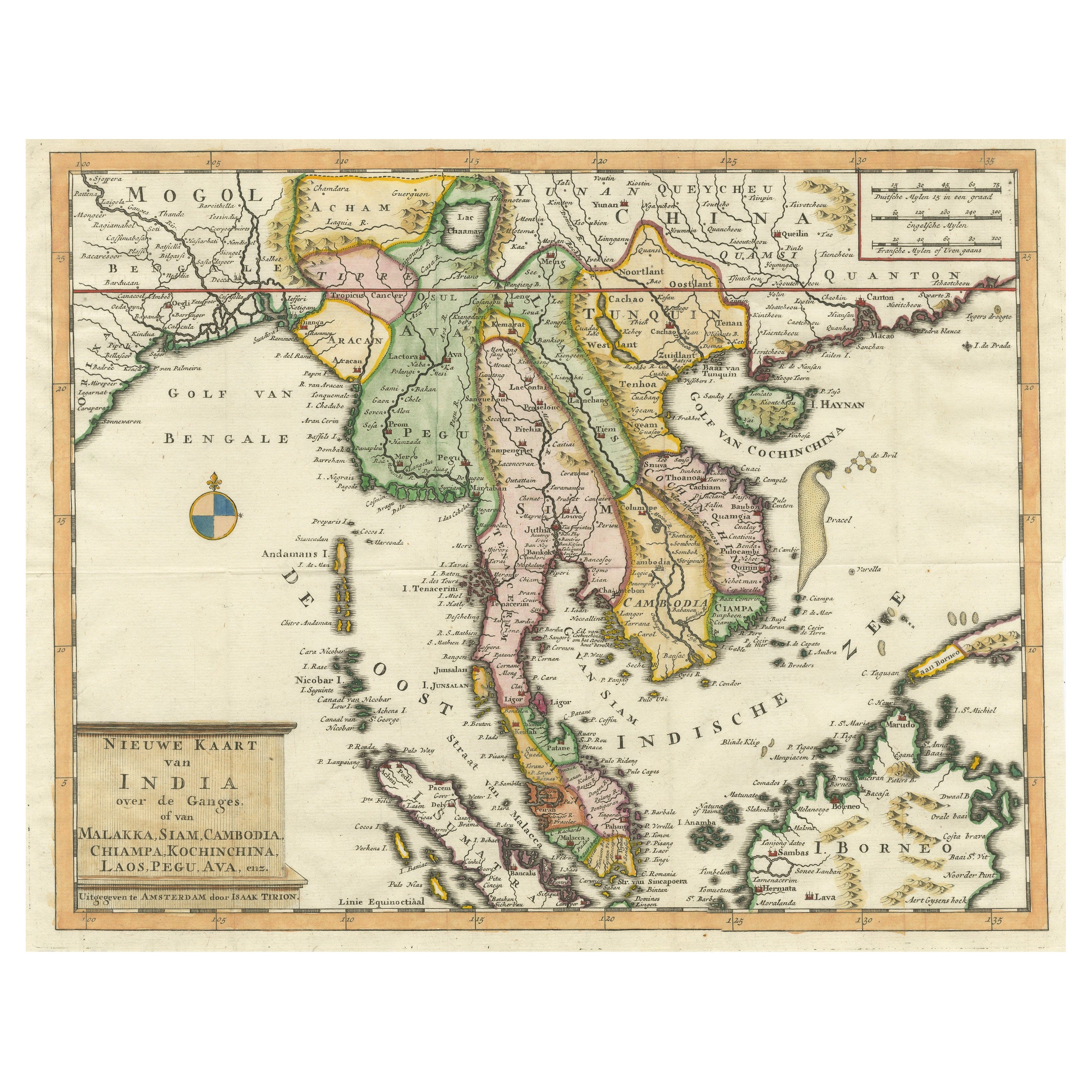
- Antique Map of Indochina, the Malaysian Peninsula and Northern SumatraLocated in Langweer, NLAntique map titled 'Nieuwe Kaart van India over de Ganges of van Malakka, Siam, Cambodia, Chiampa, Kochinchina, Laos, Pegu, Ava, enz'. Original old map of Indochina, the Malaysian Pe...Category
Antique Mid-18th Century Maps
MaterialsPaper
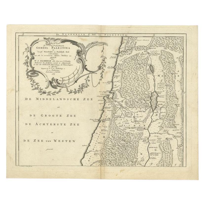
- Antique Map of the Northern Part of Biblical Palestine by Lindeman, c.1763Located in Langweer, NLAntique map titled 'De 8ste en 9de Landkaarte Geheel Palestina (..).' Map of the northern part of Biblical Palestine. With large title cartouche. Published by A. van Paddenburg, Neth...Category
Antique 18th Century Maps
MaterialsPaper


You May Also Like
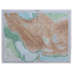
- Large Original Vintage Map of Persia / Iran, circa 1920Located in St Annes, LancashireGreat maps of Persia. Unframed. Original color. By John Bartholomew and Co. Edinburgh Geographical Institute. Published, circa 1920. Free shipping.Category
Vintage 1920s British Maps
MaterialsPaper
- Original Antique Map of the American State of Nevada, 1889Located in St Annes, LancashireGreat map of Nevada Drawn and Engraved by W. & A.K. Johnston Published By A & C Black, Edinburgh. Original colour Unframed.Category
Antique 1880s Scottish Victorian Maps
MaterialsPaper
- Original Antique Map of the American State of Oregon, 1889Located in St Annes, LancashireGreat map of Oregon Drawn and Engraved by W. & A.K. Johnston Published By A & C Black, Edinburgh. Original colour Unframed.Category
Antique 1880s Scottish Victorian Maps
MaterialsPaper
- Original Antique Map of the American State of Pennsylvania, 1889Located in St Annes, LancashireGreat map of Pennsylvania Drawn and Engraved by W. & A.K. Johnston Published By A & C Black, Edinburgh. Original colour Unframed. Repair to a minor tear on bottom edge.Category
Antique 1880s Scottish Victorian Maps
MaterialsPaper
- Original Antique Map of the American State of Washington, 1889Located in St Annes, LancashireGreat map of Washington Drawn and Engraved by W. & A.K. Johnston Published By A & C Black, Edinburgh. Original colour Unframed.Category
Antique 1880s Scottish Victorian Maps
MaterialsPaper
- Large Original Vintage Map of The World, circa 1920Located in St Annes, LancashireGreat map of The World Original color. Good condition / minor foxing Published by Alexander Gross Unframed.Category
Vintage 1920s English Maps
MaterialsPaper