Items Similar to Philippine Meteorological & Seismological Network Map – Manila Observatory, 1899

Want more images or videos?
Request additional images or videos from the seller
1 of 10
Philippine Meteorological & Seismological Network Map – Manila Observatory, 1899
$545.90
£407.60
€460
CA$766.97
A$839.17
CHF 433.01
MX$10,048.98
NOK 5,497.26
SEK 5,150.41
DKK 3,503.95
About the Item
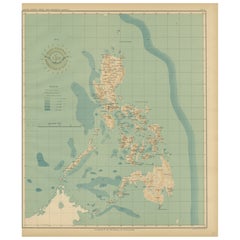
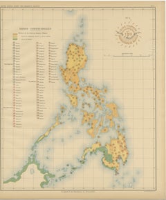
Title: Meteorological and Seismological Stations of the Philippines – Observatorio de Manila, 1899
This rare scientific chromolithograph titled “Islas Filipinas – Estaciones Meteorológicas y Sísmicas” was produced in 1899 under the direction of Rev. José Algué, S.J., Director of the Observatorio de Manila. Issued as Plate No. 5 from the Atlas de Filipinas, it is one of the earliest printed maps to document the meteorological and seismological observation network of the Philippines at the end of the 19th century.
The map shows the entire archipelago divided into numbered “Distritos meteorológicos y sísmicos” (meteorological and seismic districts), with color-shaded regions corresponding to distinct administrative zones of observation. Red symbols denote various categories of stations, as explained in the legend titled “Signos,” including Estaciones centrales, Estaciones meteorológicas-sísmicas de 1ª clase, and Estaciones meteorológicas-sísmicas de 2ª clase. Planned but not yet established stations are labeled En Proyecto, marking the ambitious scope of the network under development at the time.
This map was a product of the Jesuit scientific tradition that made the Observatorio de Manila one of Asia’s foremost centers of atmospheric and seismic research. Compiled by Filipino draftsmen under Jesuit supervision, the map reflects both meticulous fieldwork and advanced scientific organization. It bears two official markings: the red circular stamp of the “Observatorio de Manila” and the embossed seal of the “U.S. Coast and Geodetic Survey,” evidencing its inclusion in the 1900 Washington publication of the Atlas of the Philippine Islands.
The map captures a pivotal historical moment: the modernization of Philippine science under the transition from Spanish to American governance. It serves as both a scientific document and a visual testament to early meteorological and seismic research in the Pacific.
Condition: Excellent, with original color, light marginal toning, and clear institutional stamps.
Framing tips: Display in a dark walnut or mahogany frame with an off-white or soft beige mat to highlight the pastel tones and historical annotations.
Technique: Chromolithograph on paper
Maker: Rev. José Algué, S.J., Observatorio de Manila, 1899
- Dimensions:Height: 14.57 in (37 cm)Width: 12.8 in (32.5 cm)Depth: 0.01 in (0.2 mm)
- Materials and Techniques:
- Place of Origin:
- Period:
- Date of Manufacture:1899
- Condition:Condition: Excellent, with original color, light marginal toning, and clear institutional stamps.
- Seller Location:Langweer, NL
- Reference Number:Seller: BG-12176-51stDibs: LU3054346957242
About the Seller
5.0
Recognized Seller
These prestigious sellers are industry leaders and represent the highest echelon for item quality and design.
Platinum Seller
Premium sellers with a 4.7+ rating and 24-hour response times
Established in 2009
1stDibs seller since 2017
2,676 sales on 1stDibs
Typical response time: <1 hour
- ShippingRetrieving quote...Shipping from: Langweer, Netherlands
- Return Policy
Authenticity Guarantee
In the unlikely event there’s an issue with an item’s authenticity, contact us within 1 year for a full refund. DetailsMoney-Back Guarantee
If your item is not as described, is damaged in transit, or does not arrive, contact us within 7 days for a full refund. Details24-Hour Cancellation
You have a 24-hour grace period in which to reconsider your purchase, with no questions asked.Vetted Professional Sellers
Our world-class sellers must adhere to strict standards for service and quality, maintaining the integrity of our listings.Price-Match Guarantee
If you find that a seller listed the same item for a lower price elsewhere, we’ll match it.Trusted Global Delivery
Our best-in-class carrier network provides specialized shipping options worldwide, including custom delivery.More From This Seller
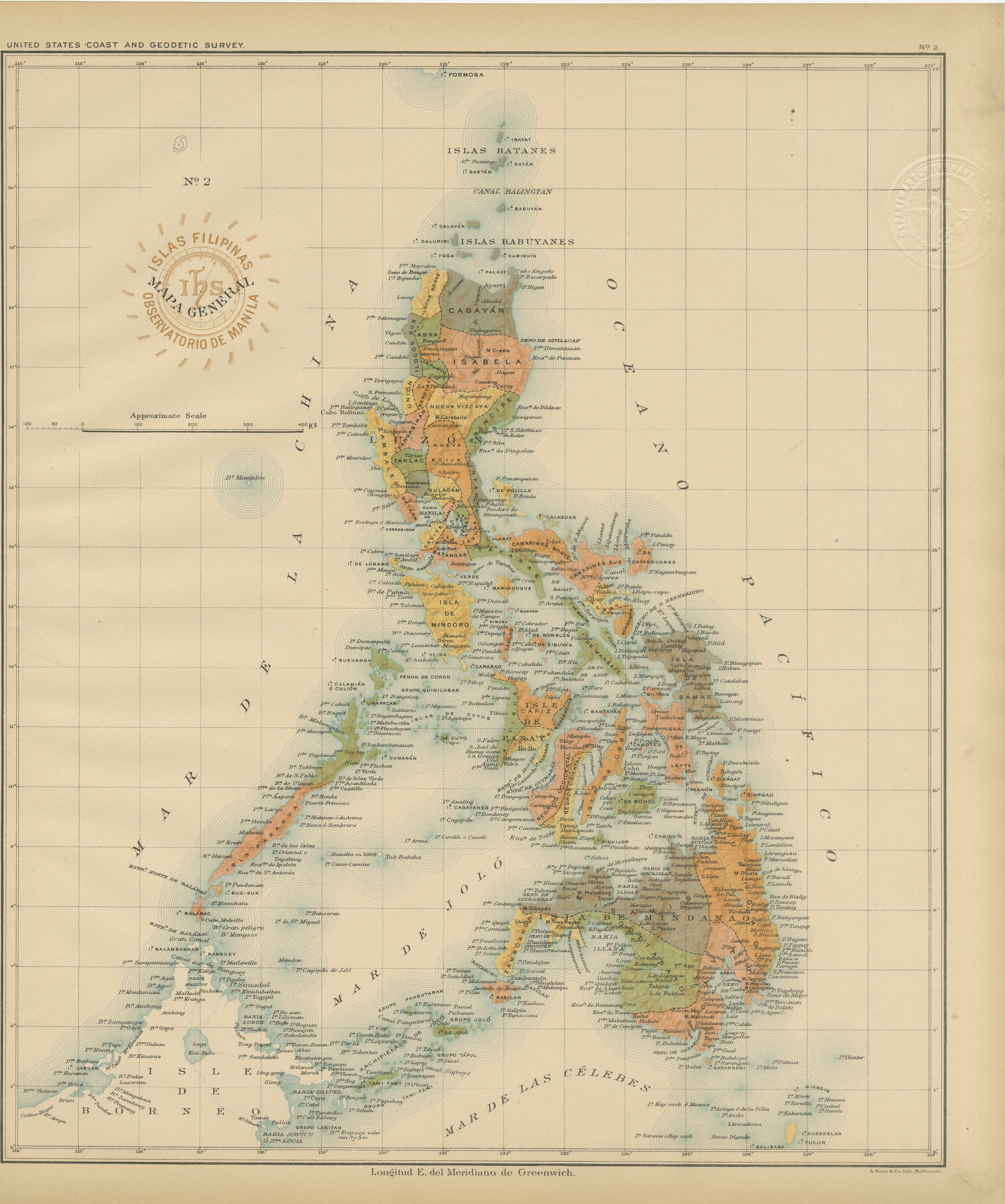
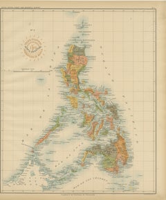
View AllAntique Map of the Philippine Islands – Observatorio de Manila, 1899
Located in Langweer, NL
Antique Map of the Philippine Islands – Observatorio de Manila, 1899
This beautiful chromolithographed map titled “Islas Filipinas” was created in 1899 under the direction of Rev. J...
Category
Antique 1890s Philippine Maps
Materials
Paper
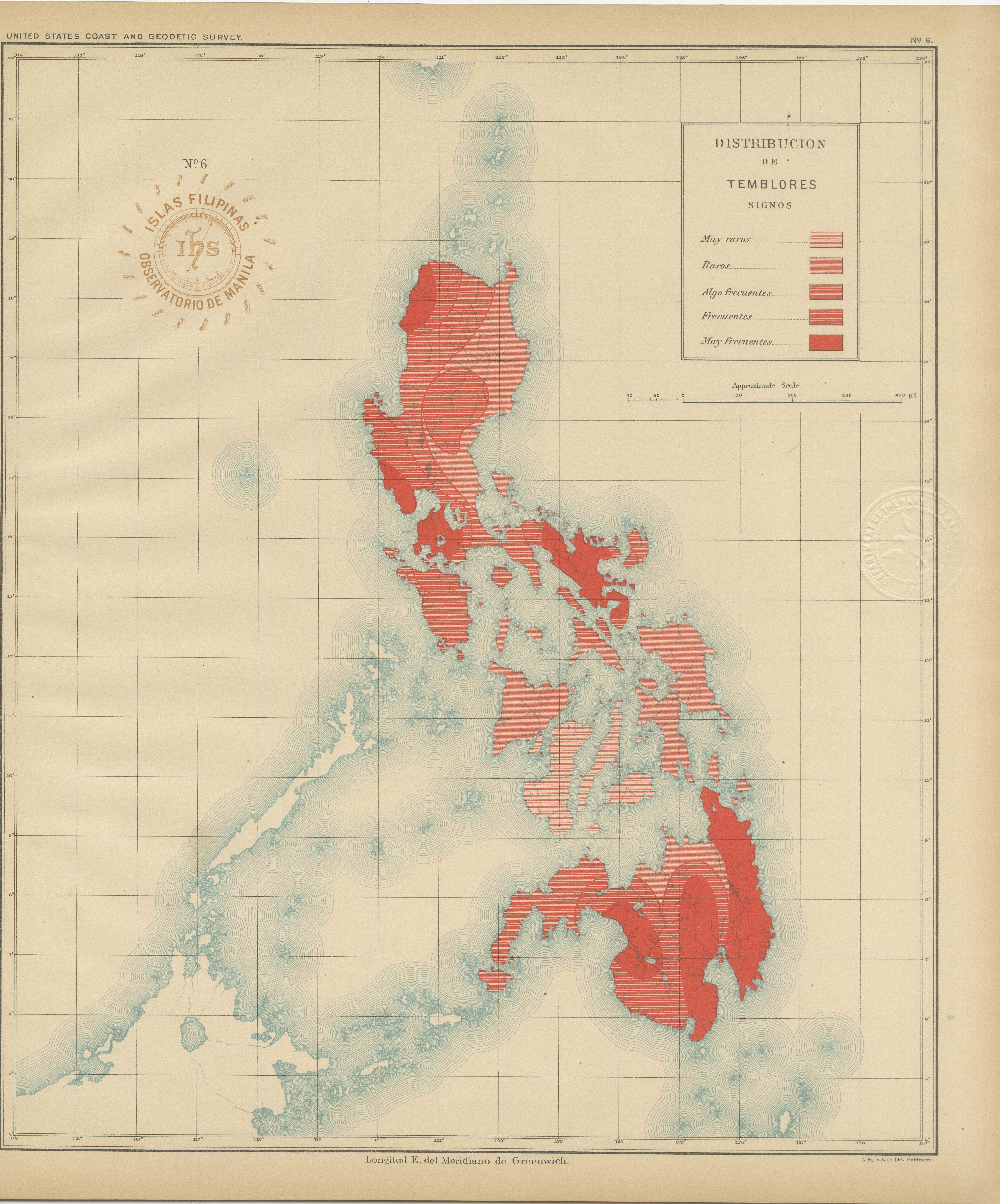
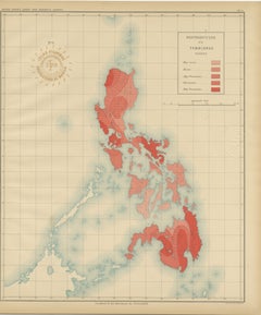
Seismic Activity Map of the Philippine Islands – Observatorio de Manila, 1899
Located in Langweer, NL
Title: Seismic Activity Map of the Philippine Islands – Observatorio de Manila, 1899
This striking chromolithograph titled “Distribución de los Temblores” (Distribution of Earthquak...
Category
Antique 1890s Philippine Maps
Materials
Paper
Orographic Map of the Philippine Islands – Observatorio de Manila, 1899
Located in Langweer, NL
Title: Orographic Map of the Philippine Islands – Observatorio de Manila, 1899
This finely executed chromolithographed map, titled “Islas Filipinas – Mapa Orográfico,” was created i...
Category
Antique 1890s Philippine Maps
Materials
Paper
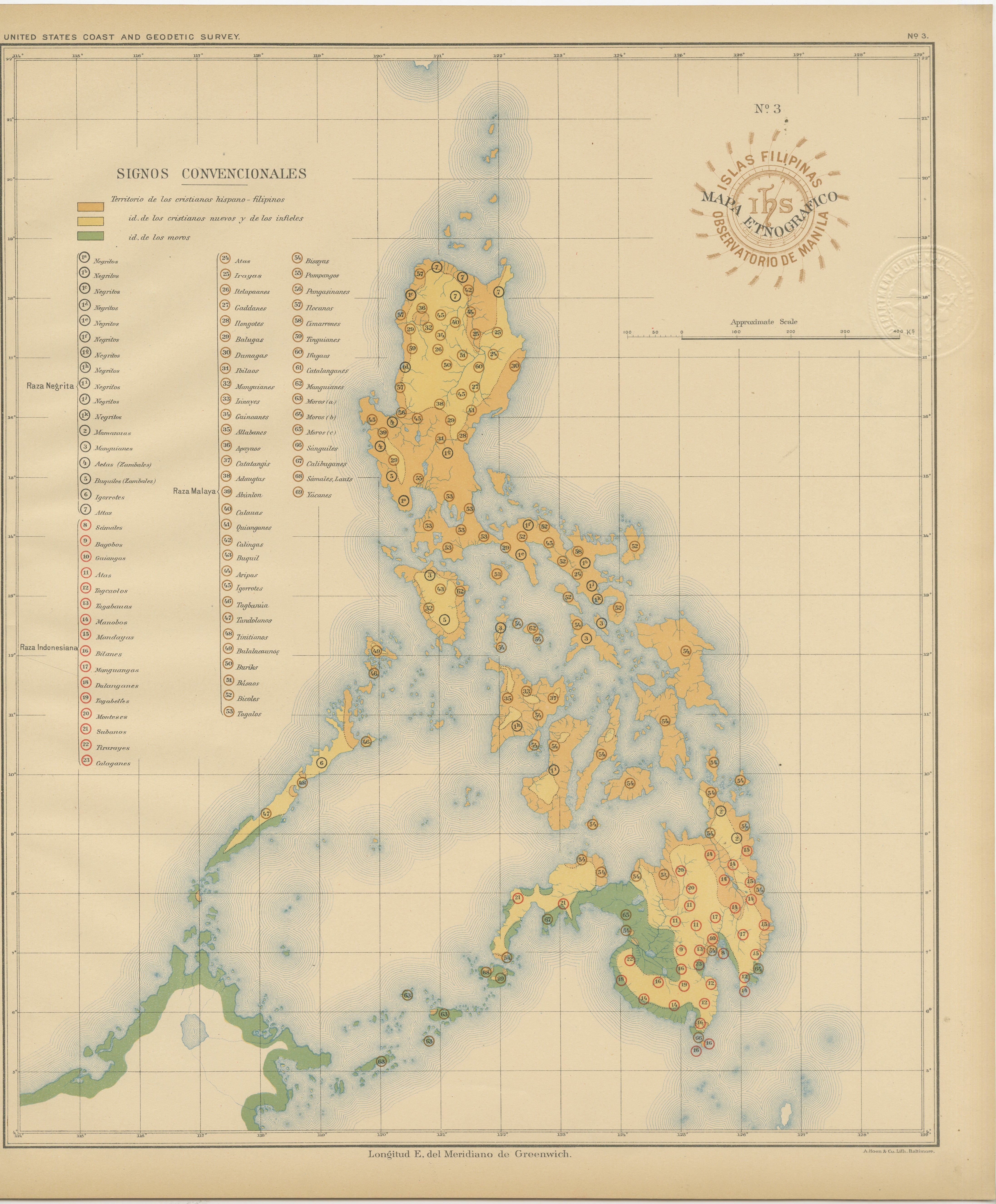
Ethnographic Map of the Philippine Islands – Observatorio de Manila, 1899
Located in Langweer, NL
Ethnographic Map of the Philippine Islands – Observatorio de Manila, 1899
This rare and fascinating chromolithographed map titled “Islas Filipinas – Mapa Etnográfico” was created in...
Category
Antique 1890s Philippine Maps
Materials
Paper
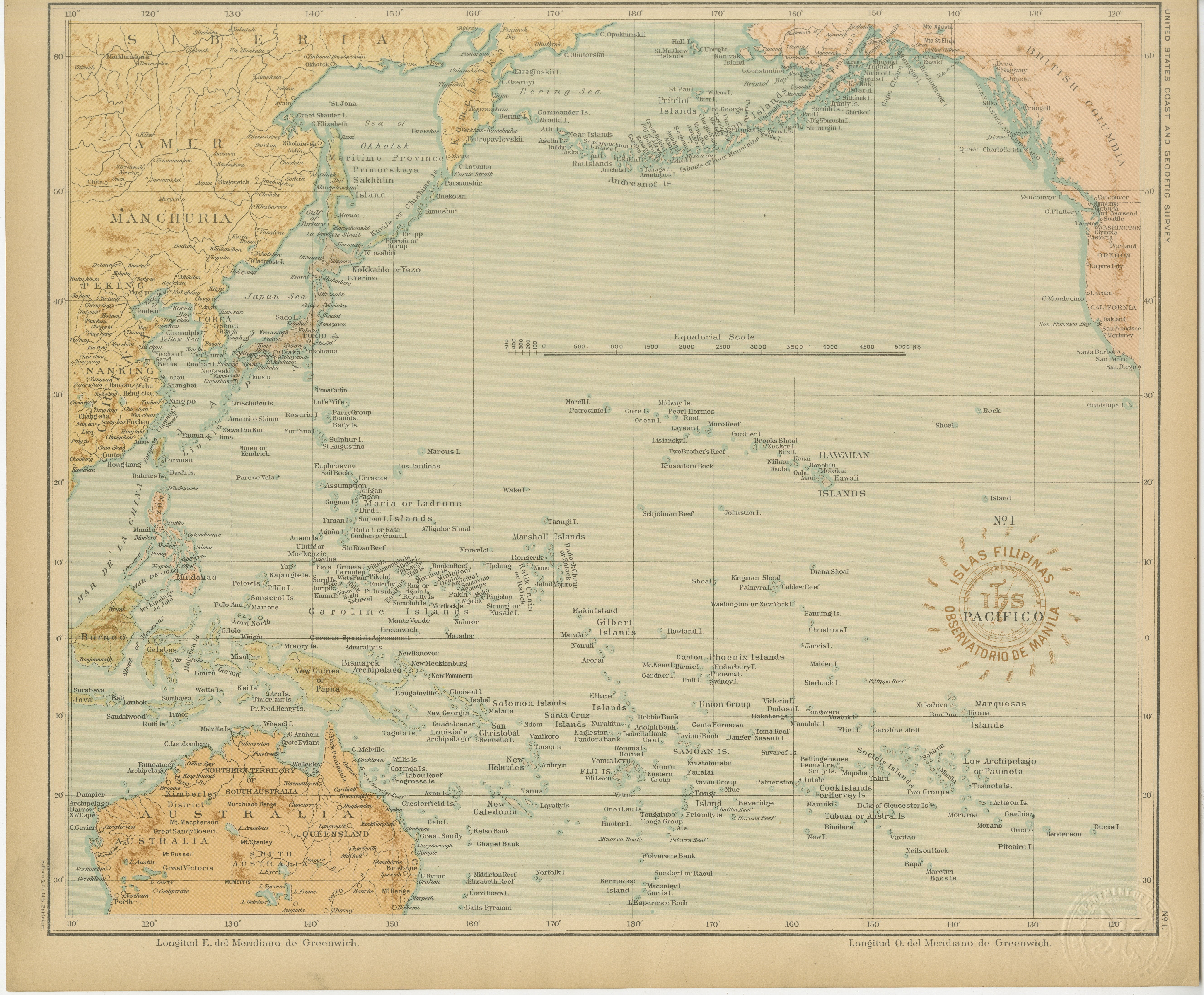
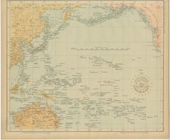
Map of the Pacific Ocean and Philippine Archipelago – Manila Observatory, 1899
Located in Langweer, NL
Title: Pacific Ocean and the Philippine Archipelago – Observatorio de Manila, 1899
Description:
This finely detailed chromolithographed map titled “Islas Filipinas – Océano Pacífico...
Category
Antique 1890s Philippine Maps
Materials
Paper
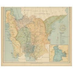
Central Luzon Topographic and Hydrographic Map – Observatorio de Manila, 1899
Located in Langweer, NL
Title: Central Luzon Topographic and Hydrographic Map – Observatorio de Manila, 1899
Description:
This highly detailed chromolithograph titled “Islas Filipinas – Luzón” was created ...
Category
Antique 1890s Philippine Maps
Materials
Paper
You May Also Like
Original Antique Map of The Philippines. C.1900
Located in St Annes, Lancashire
Fabulous map of The Philippines
Original color.
Engraved and printed by the George F. Cram Company, Indianapolis.
Published, C.1900.
Unframed.
Free shipping.
Category
Antique 1890s American Maps
Materials
Paper

Original Antique Map of US Possessions In The Pacific Ocean, C.1900
Located in St Annes, Lancashire
Fabulous map of US possessions in the Pacific Ocean
Original color.
Engraved and printed by the George F. Cram Company, Indianapolis.
Published, C.1900.
Unframed.
Free shipping.
Category
Antique 1890s American Maps
Materials
Paper

Large Original Vintage Map of S.E Asia, with a Vignette of Singapore
Located in St Annes, Lancashire
Great map of South East Asia
Original color. Good condition
Published by Alexander Gross
Unframed.
Category
Vintage 1920s English Maps
Materials
Paper

Original Antique Map of South East Asia by Thomas Clerk, 1817
Located in St Annes, Lancashire
Great map of South East Asia
Copper-plate engraving
Drawn and engraved by Thomas Clerk, Edinburgh.
Published by Mackenzie And Dent, 1817
Unframed.
Category
Antique 1810s English Maps
Materials
Paper

Large Original Vintage Map of British Island Possessions, circa 1920
Located in St Annes, Lancashire
Great map of British Island Possessions
Original color. Good condition
Published by Alexander Gross
Unframed.
Category
Vintage 1920s English Maps
Materials
Paper

Antique 1803 Italian Map of Asia Including China Indoneseia India
Located in Amsterdam, Noord Holland
Antique 1803 Italian Map of Asia Including China Indoneseia India
Very nice map of Asia. 1803.
Additional information:
Type: Map
Country of Manufacturing: Europe
Period: 19th centu...
Category
Antique 19th Century European Maps
Materials
Paper

$584 Sale Price
20% Off