Items Similar to South Sweden Map with Inset of Halmstad – Antique Map by Frederik de Wit, c.1680


Video Loading
Want more images or videos?
Request additional images or videos from the seller
1 of 14
South Sweden Map with Inset of Halmstad – Antique Map by Frederik de Wit, c.1680
$813.46
$1,016.8320% Off
£602.25
£752.8120% Off
€676
€84520% Off
CA$1,126.30
CA$1,407.8720% Off
A$1,229.65
A$1,537.0620% Off
CHF 644.65
CHF 805.8220% Off
MX$14,934.51
MX$18,668.1420% Off
NOK 8,050.66
NOK 10,063.3320% Off
SEK 7,601.97
SEK 9,502.4620% Off
DKK 5,146.53
DKK 6,433.1720% Off
About the Item
South Sweden Map with Inset of Halmstad – Antique Map by Frederik de Wit, c.1680
This richly detailed antique map titled Accurata Scaniae, Blekingae et Hallandiae Descriptio presents the southern provinces of Sweden: Scania (Skåne), Blekinge, and Halland. Published in Amsterdam by the renowned Dutch cartographer Frederik de Wit around 1680, the map exemplifies the elegance and precision of Golden Age Dutch cartography.
De Wit’s depiction includes a carefully engraved overview of the southern Swedish landscape, bounded by the Kattegat and Baltic Sea, and interspersed with forests, rivers, and settlements. Prominent cities such as Malmö, Lund, Kristianstad, and Karlskrona are noted, along with smaller towns and ecclesiastical divisions. The inclusion of the inset map of Halmstad and its surrounding coast enhances the geographic utility and regional focus of the map.
The decorative cartouche, held aloft by two cherubs, frames the title at the top center of the map, while another vignette in the upper right corner playfully depicts two cherubs operating a press. These elements add to the artistic appeal and historical charm of the piece.
Frederik de Wit (1630–1706) was one of Amsterdam’s most successful mapmakers of the late 17th century, known for his atlases, wall maps, and sea charts. His work combined geographical accuracy with artistic beauty, and his maps were widely distributed across Europe. This map is a fine example of his craftsmanship and the enduring importance of this border region between Denmark and Sweden.
Condition report: Good condition with attractive contemporary hand coloring. General age toning with some faint creases near the centerfold. Blank verso, with two small repairs. Please review the image carefully for details.
Framing tips: A natural wood or gold-leaf frame with a light beige or pale green mat would highlight the original hand coloring. Opt for UV-resistant glass to protect the pigments over time.
- Dimensions:Height: 20.87 in (53 cm)Width: 24.41 in (62 cm)Depth: 0.02 in (0.5 mm)
- Materials and Techniques:Paper,Engraved
- Place of Origin:
- Period:Late 17th Century
- Date of Manufacture:1680
- Condition:Repaired: Two small repairs on the back with tape. Good condition with attractive contemporary hand coloring. General age toning with some faint creases near the centerfold. Blank verso, with two small repairs. Please review the image carefully for details.
- Seller Location:Langweer, NL
- Reference Number:Seller: BG-067921stDibs: LU305439810221
About the Seller
5.0
Recognized Seller
These prestigious sellers are industry leaders and represent the highest echelon for item quality and design.
Platinum Seller
Premium sellers with a 4.7+ rating and 24-hour response times
Established in 2009
1stDibs seller since 2017
2,641 sales on 1stDibs
Typical response time: <1 hour
- ShippingRetrieving quote...Shipping from: Langweer, Netherlands
- Return Policy
Authenticity Guarantee
In the unlikely event there’s an issue with an item’s authenticity, contact us within 1 year for a full refund. DetailsMoney-Back Guarantee
If your item is not as described, is damaged in transit, or does not arrive, contact us within 7 days for a full refund. Details24-Hour Cancellation
You have a 24-hour grace period in which to reconsider your purchase, with no questions asked.Vetted Professional Sellers
Our world-class sellers must adhere to strict standards for service and quality, maintaining the integrity of our listings.Price-Match Guarantee
If you find that a seller listed the same item for a lower price elsewhere, we’ll match it.Trusted Global Delivery
Our best-in-class carrier network provides specialized shipping options worldwide, including custom delivery.More From This Seller
View AllSouthern Sweden Provinces Map – Homann’s ‘Nova Tabula Scaniae’, ca. 1730
Located in Langweer, NL
Southern Sweden Provinces Map – Homann’s ‘Nova Tabula Scaniae’, ca. 1730
Antique map titled 'Nova Tabula Scaniae in qua sunt Scania, Blekingia et Hallandia'. This decorative map sho...
Category
Antique Mid-18th Century German Maps
Materials
Paper

$529 Sale Price
20% Off
Antique Map of the Region of Saintonge by Janssonius, 1657
By Johannes Janssonius
Located in Langweer, NL
Antique map 'La Saintonge vers le Midy avecq le Brovageais'. Decorative map of the Saintonge region, a former province of France located on the west central Atlantic coast. This map ...
Category
Antique Mid-17th Century Maps
Materials
Paper

$577 Sale Price
20% Off
Antique Map of Scandinavia by T. Jefferys, circa 1750
Located in Langweer, NL
Antique map titled 'Sweden, Denmark, Norway & Finland'. An original mid-18th century copper engraved antique map of Scandinavia by Thomas Jefferys....
Category
Antique Mid-18th Century Maps
Materials
Paper

$182 Sale Price
20% Off
Map of the Duchy of Pomerania – Antique Engraving by P. Schenk Jr., c. 1750
Located in Langweer, NL
Map of the Duchy of Pomerania – Antique Engraving by P. Schenk Jr., c. 1750
Antique map titled 'Ducatus Pomeraniae Tabula Generalis'. This historical map presents the Duchy of Pomer...
Category
Antique Mid-18th Century Dutch Maps
Materials
Paper

$481 Sale Price
20% Off
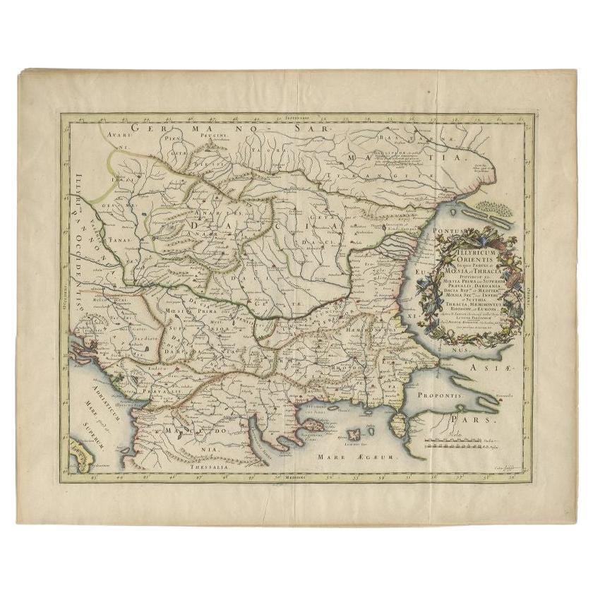
Antique Map of the Region Around the Baltic Sea by Cordier, c.1670
Located in Langweer, NL
Antique map titled 'Illyricum Orientis: In quo Partes II Moesia et Thracia'. Engraved map of the area west of the Baltic Sea, present day Bulgaria, Romania, and Turkey. The map is ba...
Category
Antique 17th Century Maps
Materials
Paper
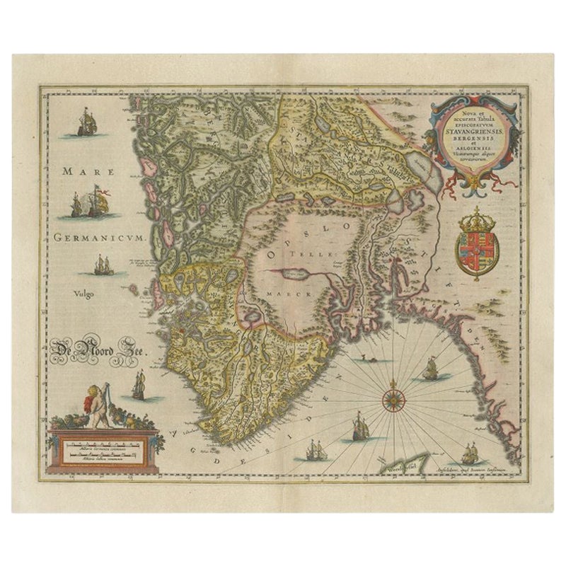
Antique Map of Southern Norway by Janssonius, c.1650
Located in Langweer, NL
"Antique map titled 'Nova et Accurata Tabula Episcopatuum Stavangriensis et Asloiensis'. Old map of the southern part of Norway, it covers the region around Bergen. Decorated with ma...
Category
Antique 17th Century Maps
Materials
Paper
$725 Sale Price
20% Off
You May Also Like
1646 Jansson Map Entitled "Procinvia Connactiae, " Ric.a006
Located in Norton, MA
1646 Jansson map entitled
"Procinvia connactiae,"
Ric.a006
Description: The PROVINCE of CONNAVGT 490 x 380From vol 4 of Jansson's Atlas Novus 1646, published in Amsterdam with...
Category
Antique 17th Century Unknown Maps
Materials
Paper

Antique Map - Gallia - Etching by Johannes Janssonius - 1650s
By Johannes Janssonius
Located in Roma, IT
Antique Map - Gallia is an antique map realized in 1650 by Johannes Janssonius (1588-1664).
The Map is Hand-colored etching, with coeval watercoloring.
Good conditions with slight ...
Category
1650s Modern Figurative Prints
Materials
Etching

1640 Willem Blaeu Map Entitled "Contado di molise et principato vltra, " Ric.a003
By Willem Blaeu
Located in Norton, MA
1640 Willem Blaeu map entitled
"Contado di molise et principato vltra,"
Colored
Ric. a003
Measures: 38 x 49.6 cm and wide margins
DBLAEU.
Cou...
Category
Antique 17th Century Dutch Maps
Materials
Paper

1657 Janssonius Map of Vermandois and Cappelle, Ric. A-004
Located in Norton, MA
1657 Janssonius map of
Vermandois and Cappelle
Ric.a004
Description: Antique map of France titled 'Descriptio Veromanduorum - Gouvernement de la Cappelle'. Two detailed maps o...
Category
Antique 17th Century Unknown Maps
Materials
Paper

1627 Hendrik Hondius Map Entitled "Vltoniae Orientalis Pars, " Ric.a009
Located in Norton, MA
1627 Hendrik Hondius map entitled
"Vltoniae orientalis pars,"
Ric.a009
Title:
Vltoniae orientalis : pars
Title (alt.) :
Ultoniae orientalis pars
Creator:
Mercator, Gerh...
Category
Antique 17th Century Dutch Maps
Materials
Paper

1643 Willem&Joan Blaeu Map NW Flanders "Flandriae Teutonicae Pars Prientalior
Located in Norton, MA
1643 Willem and Joan Blaeu map of northwest Flanders, entitled
"Flandriae Teutonicae Pars Prientalior,"
Ric0012
" Authentic" - Map of the northwest Fl...
Category
Antique 17th Century Dutch Maps
Materials
Paper

More Ways To Browse
17th Century Dutch Wood Frames
Swedish 17th Century Furniture
Blue Kilim Vintage
Contemporary Side Tables And Stools
Decorative Wall Plate
Mid Century Modern Corner Chair
Dining Tables With Brass Inlay
Oak Mid Century Armchair
Solid Wood Side Table Stool
Antique Marble Top Hall Table
Bird And Butterfly
Old Carpet
Porcelain Modern Hand Painted
Bent Plywood
1960 Italian Dining Set
Italian Giltwood Table
Polished Bronze Table
Antique Laurel Wreath