Items Similar to Vintage Map of London – Bartholomew’s Plan of Central London, c.1929


Want more images or videos?
Request additional images or videos from the seller
1 of 10
Vintage Map of London – Bartholomew’s Plan of Central London, c.1929
$1,411.10
£1,049.05
€1,190
CA$1,955.52
A$2,180.03
CHF 1,136.98
MX$26,361.65
NOK 14,292.36
SEK 13,523.43
DKK 9,059.78
About the Item
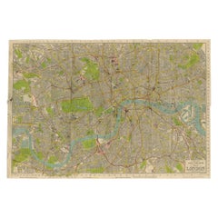
London Central Map c.1929 – Bartholomew Antique City Plan
This detailed city plan, titled “Bartholomew’s Plan of London, Central Area,” was published by John Bartholomew & Son, Edinburgh, in the early 20th century (c.1929). Bartholomew, one of Britain’s most respected cartographic firms, was known for its clarity, accuracy, and the use of subtle yet effective color schemes.
The map covers central London with exceptional detail, extending from Paddington and Regent’s Park in the west to the East India Docks and Greenwich in the east, and from Hampstead Heath in the north down to Clapham and Greenwich in the south. Streets, squares, parks, and railways are finely engraved, while key buildings and institutions are highlighted in black, including Buckingham Palace, the Houses of Parliament, St. Paul’s Cathedral, the Tower of London, and major railway termini such as King’s Cross, Paddington, and Waterloo.
Color coding marks borough divisions and major thoroughfares, while the River Thames flows through the center, with its distinctive bends and docks prominently shown. Parks such as Hyde Park, Regent’s Park, and Green Park appear in green, providing clear orientation within the dense urban fabric.
Plans of London by Bartholomew were issued in various formats for guidebooks, atlases, and folding tourist maps, making them practical tools for visitors and residents alike. This edition captures London between the Edwardian era and the interwar years, a period of rapid growth and modernization before the transformative effects of the Second World War.
Condition: Very good. Original color printing, with strong paper and sharp impressions. Folding map. Light age toning and minor handling wear in margins, but overall well preserved.
Framing tips: This map makes an excellent display piece for London enthusiasts. A black or dark oak frame with a cream mat will enhance the clarity of the engraving, while a green secondary mat could draw attention to the parks and open spaces.
Technique: Lithograph with original printed color
Maker: John Bartholomew & Son, Edinburgh, c.1929
Collector’s note: John Bartholomew & Son was one of the leading British mapmaking firms of the 19th and 20th centuries. Their London plans combined elegance and precision, and today are valued both as historical records and as decorative works. Maps like this, showing the city between the Victorian and modern eras, are especially sought after by collectors of London history.
- Dimensions:Height: 23.23 in (59 cm)Width: 33.08 in (84 cm)Depth: 0.01 in (0.2 mm)
- Materials and Techniques:
- Place of Origin:
- Period:
- Date of Manufacture:circa 1929
- Condition:Condition: Good. Original linen backing with fold lines as issued. Some light toning and minor wear at fold intersections, but image remains clear and paper stable. Marginal foxing in places, consistent with age and handling.
- Seller Location:Langweer, NL
- Reference Number:Seller: BG-14098-21stDibs: LU3054346392792
About the Seller
5.0
Recognized Seller
These prestigious sellers are industry leaders and represent the highest echelon for item quality and design.
Platinum Seller
Premium sellers with a 4.7+ rating and 24-hour response times
Established in 2009
1stDibs seller since 2017
2,589 sales on 1stDibs
Typical response time: <1 hour
- ShippingRetrieving quote...Shipping from: Langweer, Netherlands
- Return Policy
Authenticity Guarantee
In the unlikely event there’s an issue with an item’s authenticity, contact us within 1 year for a full refund. DetailsMoney-Back Guarantee
If your item is not as described, is damaged in transit, or does not arrive, contact us within 7 days for a full refund. Details24-Hour Cancellation
You have a 24-hour grace period in which to reconsider your purchase, with no questions asked.Vetted Professional Sellers
Our world-class sellers must adhere to strict standards for service and quality, maintaining the integrity of our listings.Price-Match Guarantee
If you find that a seller listed the same item for a lower price elsewhere, we’ll match it.Trusted Global Delivery
Our best-in-class carrier network provides specialized shipping options worldwide, including custom delivery.More From This Seller
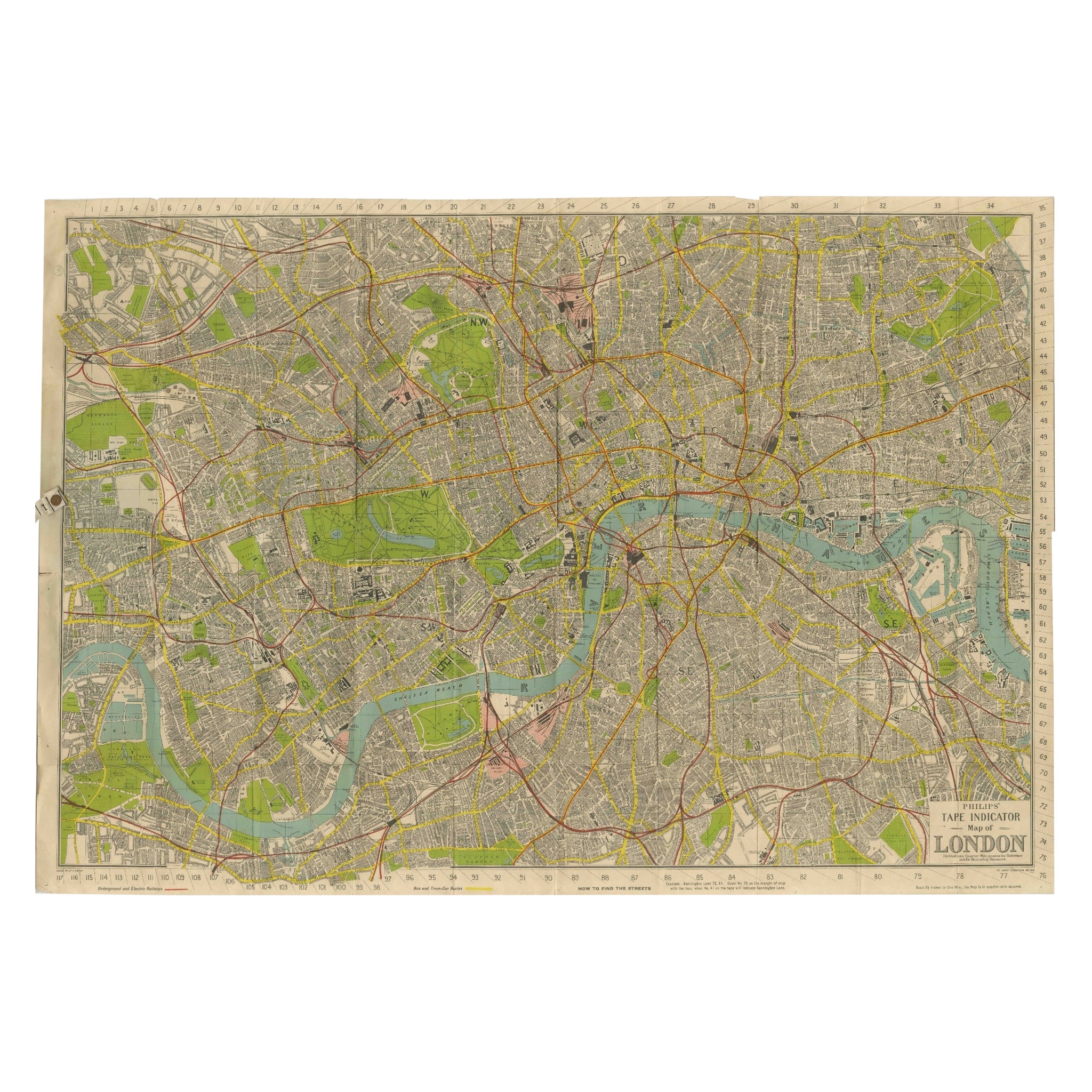
View AllVintage Map of London – Phillips’ Tape Indicator Map of Central London, c.1930
Located in Langweer, NL
Phillips Tape Indicator Map of London c.1930 – Antique City Plan
This large and detailed map of central London is titled “Phillips’ Tape Indicator Map of London.” It was published b...
Category
Early 20th Century Scottish Maps
Materials
Paper
Antique Map of the City of London by Balbi '1847'
Located in Langweer, NL
Antique map titled 'London'. Original antique map of the city of London. This map originates from 'Abrégé de Géographie (..)' by Adrien Balbi. Published 1847.
Category
Antique Mid-19th Century Maps
Materials
Paper

$189 Sale Price
20% Off
Antique Map of London by Tirion '1754'
Located in Langweer, NL
Antique map titled 'Kaart van Londen enz. en van het naby gelegen land ruim een Uur gaans rondsom dezelve Stad; getrokken uit de groote gemeeten Kaart van Hr. John Rocque'. In the se...
Category
Antique Mid-18th Century Maps
Materials
Paper

$758 Sale Price
20% Off
Antique Copper Engraving of Folding Plan of London, Published in 1804
Located in Langweer, NL
This rare map comes originally from the publication: Modern London: Being the History and Present State of the British Metropolis.
It was published in London and Printed for Richard...
Category
Antique Early 1800s Maps
Materials
Paper
$711 Sale Price
20% Off
Antique Map of London Showing the Area from Essex to Surrey, England, 1741
Located in Langweer, NL
Antique map titled 'Regionis quae est circa Londinum specialis repraesentatio (..)'
Very detailed map showing the area from Essex to Surrey and shows a lovely view of London with a high level of detail, stretching from Old London Bridge...
Category
Antique 18th Century Maps
Materials
Paper
$1,375 Sale Price
20% Off
Paris and Surroundings – Antique Map by Gall and Inglis, Published 1843
Located in Langweer, NL
Antique Map of Paris and Environs by Gall and Inglis, 1843
This finely detailed map titled "Gall & Inglis’ Plan of Paris and Environs" was published in 1843 and provides a fascinati...
Category
Antique Mid-19th Century English Maps
Materials
Paper

You May Also Like
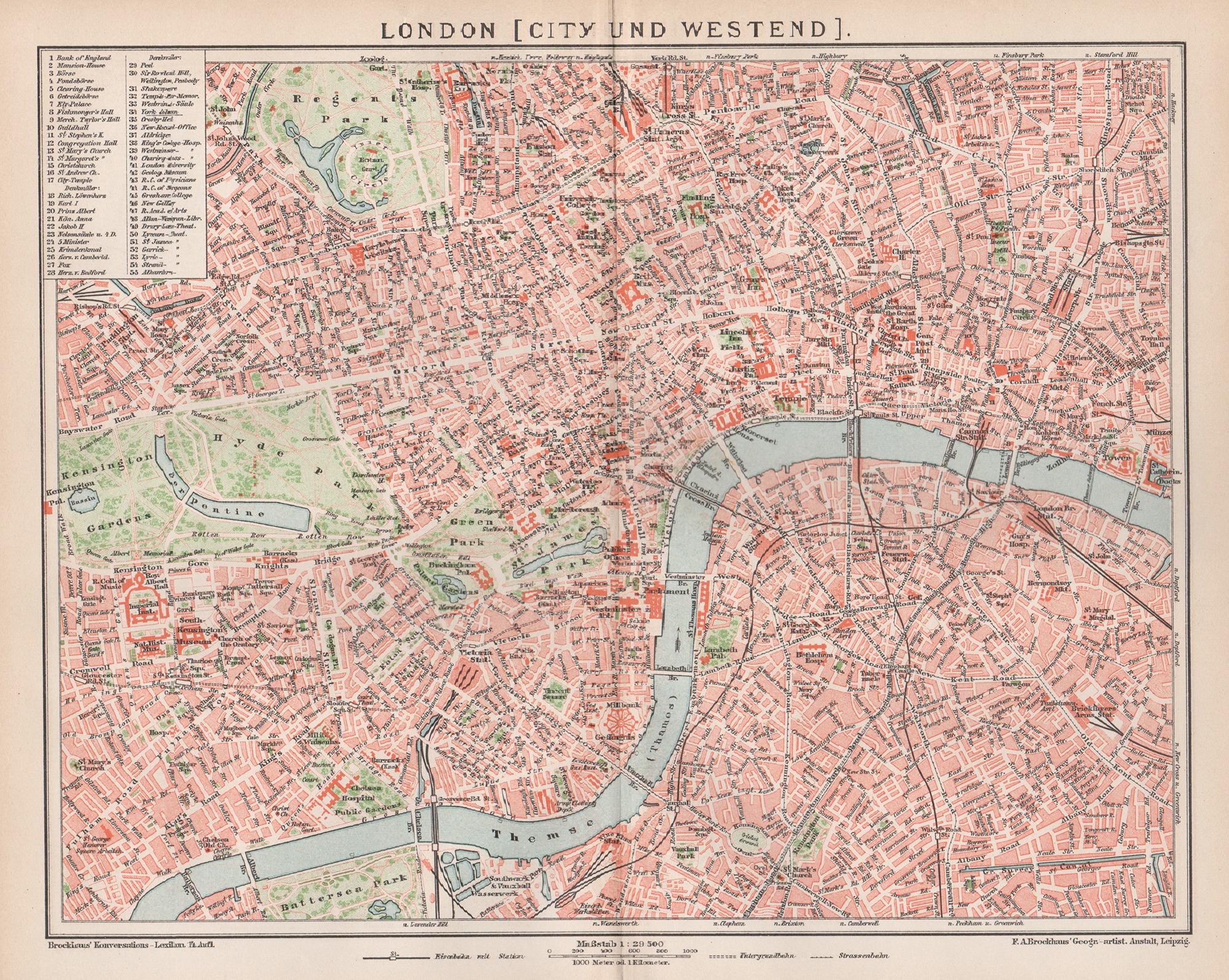
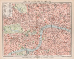
London, City and West End. Antique Map City Plan Chromolithograph, circa 1895
Located in Melbourne, Victoria
'London (City Und Westend)'
Colour lithograph. 1895.
250mm by 305mm (sheet).
Late 19th century German lithograph plan of London, City and West End.
Central vertical fold.
Category
Late 19th Century Victorian More Prints
Materials
Lithograph
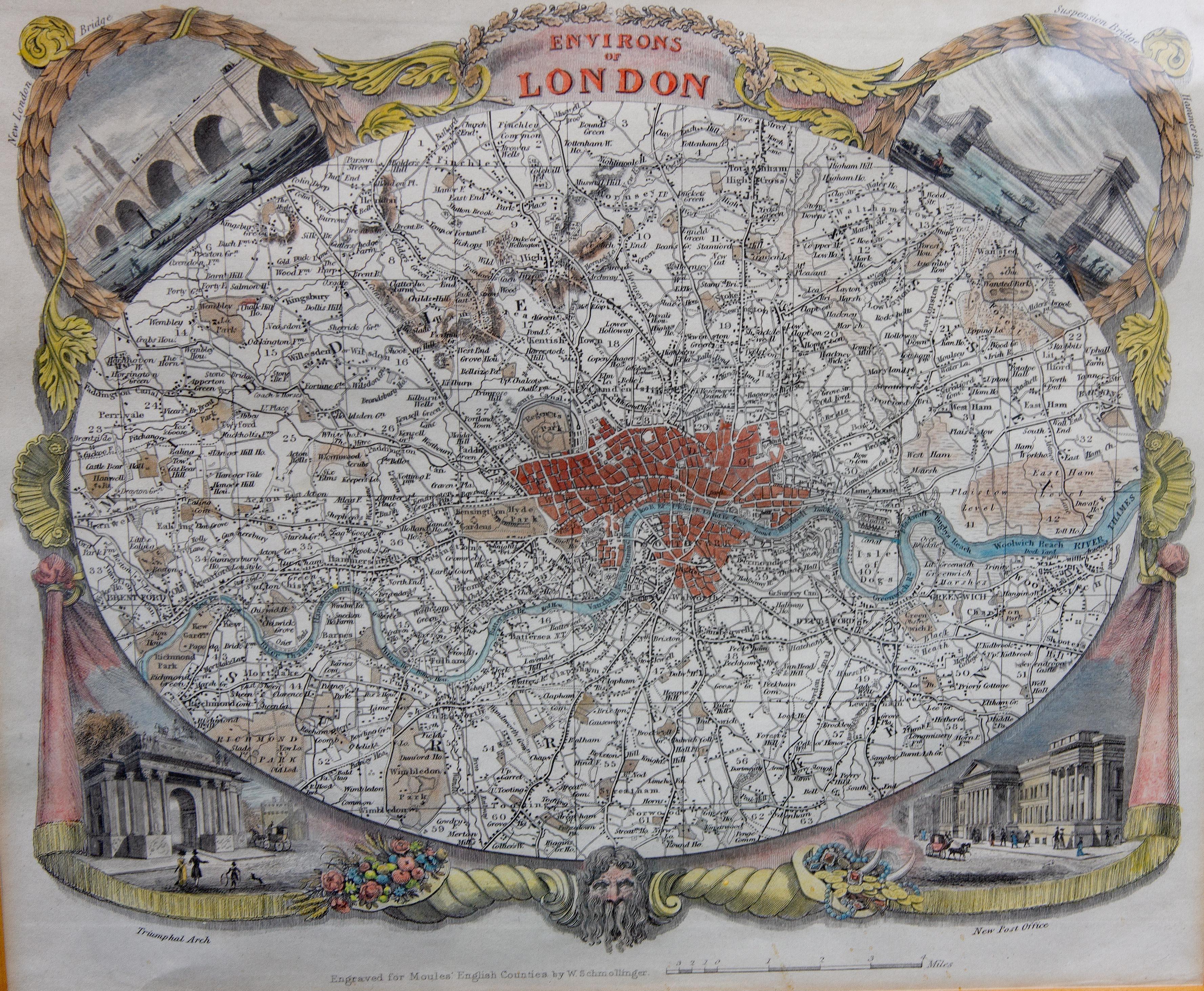
Antique Map of London by Thomas Moule and William Schmollinger
Located in Rochester, NY
Decorative engraved map of London by William Schmollinger for Moule's English County maps. Hand colored. Circa 1830's.
Category
Antique Early 19th Century English Prints
Materials
Paper

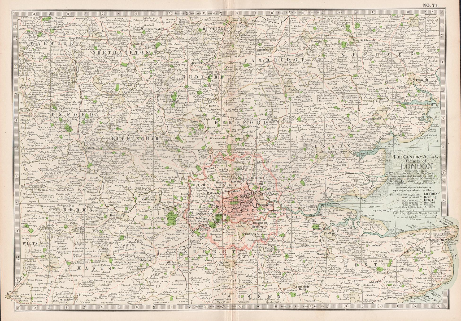
Vicinity of London, England, United Kingdom. Century Atlas antique map
Located in Melbourne, Victoria
'The Century Atlas. Vicinity of London, England, United Kingdom.'
Original antique map, 1903.
Central fold as issued. Map name and number printed on the reverse corners.
Sheet 29.5...
Category
Early 20th Century Victorian More Prints
Materials
Lithograph

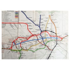
Original Antique Map of The London Underground. 1911
Located in St Annes, Lancashire
Superb map of The London Underground
Published by Ward Lock, 1911
Folding map. Printed on paper
Unframed.
Good condition/ Minor repair to an edge tear on right edge ( shown in ...
Category
Vintage 1910s English Maps
Materials
Canvas, Paper
Large Scale Map of the London Metropolis
Located in Dallas, TX
The product is a large scale map of the London Metropolis, specifically focusing on the city in intricate detail. It would be a valuable collectible for those interested in maps and ...
Category
Mid-20th Century English Maps
Materials
Paper
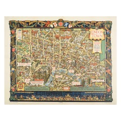
Original Vintage Poster London Town Pictorial Map Southern Railway Underground
By Kerry Lee
Located in London, GB
Original vintage Travel By Train map poster for London Town by the British artist, illustrator and poster designer Kerry Lee (1902-1988) featuring a detailed...
Category
Vintage 1930s British Posters
Materials
Paper