Items Similar to German Globe by C. Abel-Klinger, Nuremberg, circa 1860


Video Loading
Want more images or videos?
Request additional images or videos from the seller
1 of 22
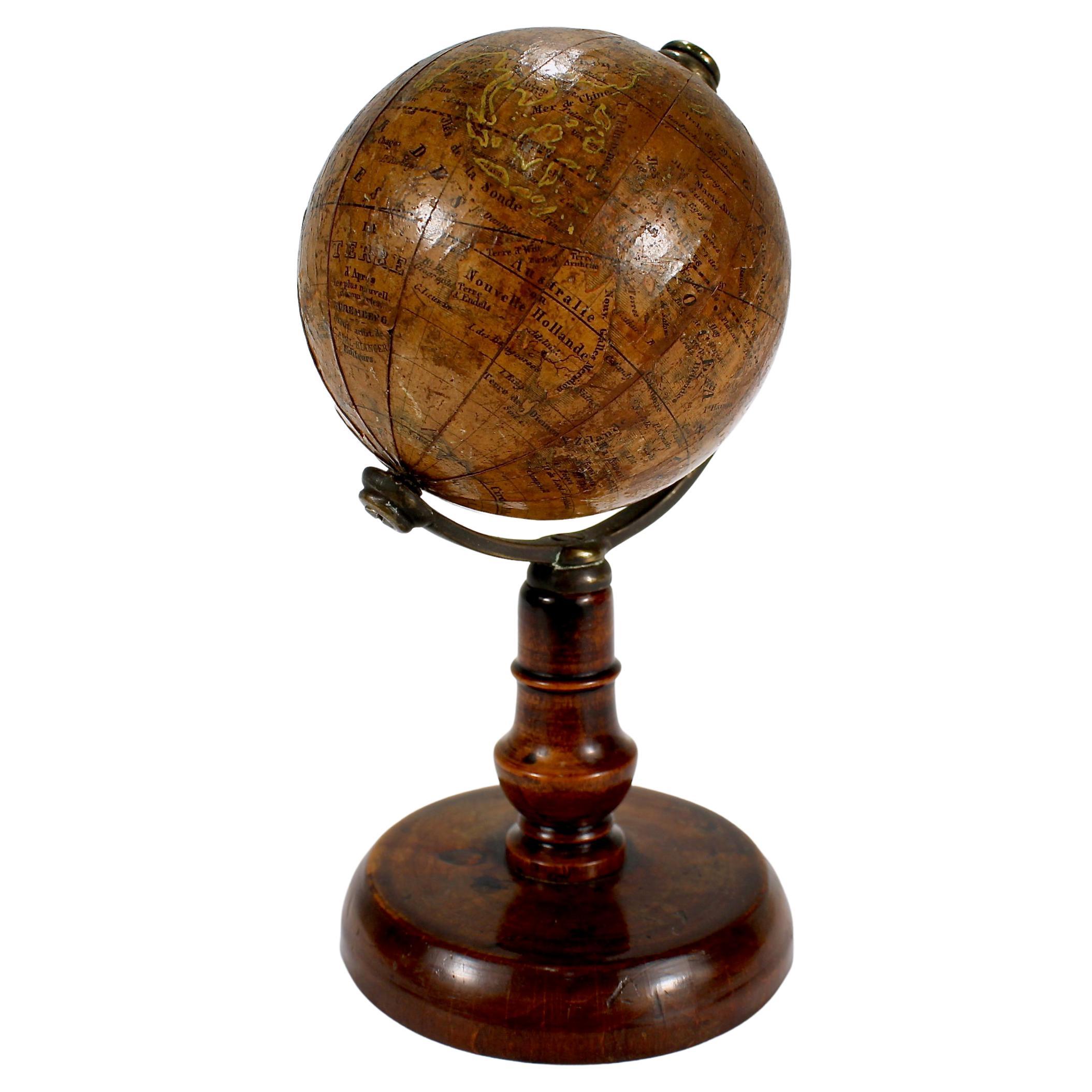
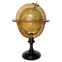
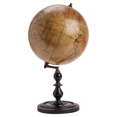
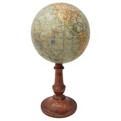
German Globe by C. Abel-Klinger, Nuremberg, circa 1860
$4,180.26
£3,108.29
€3,500
CA$5,871.37
A$6,463.95
CHF 3,303.74
MX$77,148.96
NOK 42,063.63
SEK 39,362.18
DKK 26,665.82
About the Item
Terrestrial globe
Artistic company C. Abel - Klinger
Nuremberg, circa 1860
H cm 31 x 22 cm (12.20 x 8.66 in); sphere 14 cm (5.51 in) in diameter
lb 2.30 (kg 1.04)
State of conservation: good. On the sphere there are slight visible signs of accidental bumping at the poles, as well as on New Guinea and England (vertical and more visible); some ink stains, especially at the South Pole and on the meridian that crosses North America.
The globe is composed of twelve whole gores of printed paper, juxtaposed and glued on a sphere made with a chalky base mixture.
The circle of the meridian, made of brass, bears the degrees of latitude.
A hollow octagon of wood bears the circle of the horizon, which has been printed on paper and glued on. It is marked in French with the amplitude, the direction of the winds, the days and months of the year and the names and symbols of the zodiac.
The globe is in French; there are no national boundaries.
Much of equatorial and southern Africa is unexplored. Lake Tanganyika is barely outlined, but Lake Victoria is missing: both of these were described for the first time in 1858. The southwestern part of the United States is also undescribed. Australia (which was so named after 1829) is called both “Australie”, and still “Nouv. le Hollande”. Tasmania is still defined as “Terre de Diemen”: in reality it should have been called “Terre de Van Diemen” (Van Diemen’s Land), a name used until 1856, when the island definitively assumed the name of Tasmania.
The base is made of wood and is composed of four arched uprights that support the circle of the horizon and end in a turned column. This rests, in turn, on a square base with concave sides.
In the southern Indian Ocean, between South Africa and Australia, the globe bears a cartouche with the inscription:
LA
TERRE
D’aprés
les plus nouvelles découvertes
NUREMBERG
institut artistique de
C. ABEL – KLINGER
Editeurs
Georg Johann Klinger (Nuremberg, 1764-1806) began publishing his first globes in 1790 under the name "J. G. Klinger’schen Kunsthandlung". After his death, the widow continued the activity until 1831, when it was bought by Johann Paul Dreykorn (1805-1875), who continued to publish globes with the same heading. In 1852 Carl Abel joined the management of the company and the name changed to "C. Abel-Klinger Kunsthandlung", as can also be seen in the cartouche of the present globe.
The company remained active until the beginning of the 20th century, publishing globes in various languages and in various formats.
Bibliography:
Van Der Krogt, Peter. Old Globes in the Netherlands, Utrecht 1984, pp. 173-179;
Dekker, Elly - Van Der Krogt, Peter. Globes from the Western World, London 1993, pp. 102, 106;
Van Der Krogt, Peter. Globes Neederlandici, Utrecht 1993, pp. 395-396;
Dekker, Elly. Globes at Greenwich, Oxford 1999, pp. 384-390.
- Creator:C. Abel-Klinger (Maker)
- Dimensions:Height: 12.21 in (31 cm)Diameter: 8.67 in (22 cm)
- Style:Other (Of the Period)
- Materials and Techniques:
- Place of Origin:
- Period:
- Date of Manufacture:circa 1860
- Condition:Minor losses. Minor fading. On the sphere there are slight visible signs of accidental bumping at the poles, as well as on New Guinea and England (vertical and more visible); some ink stains, especially at the South Pole and on the meridian that crosses North America.
- Seller Location:Milano, IT
- Reference Number:1stDibs: LU4352217134262
About the Seller
4.3
Vetted Professional Seller
Every seller passes strict standards for authenticity and reliability
Established in 1860
1stDibs seller since 2018
21 sales on 1stDibs
Associations
International Confederation of Art and Antique Dealers' Associations
- ShippingRetrieving quote...Shipping from: Milano, Italy
- Return Policy
Authenticity Guarantee
In the unlikely event there’s an issue with an item’s authenticity, contact us within 1 year for a full refund. DetailsMoney-Back Guarantee
If your item is not as described, is damaged in transit, or does not arrive, contact us within 7 days for a full refund. Details24-Hour Cancellation
You have a 24-hour grace period in which to reconsider your purchase, with no questions asked.Vetted Professional Sellers
Our world-class sellers must adhere to strict standards for service and quality, maintaining the integrity of our listings.Price-Match Guarantee
If you find that a seller listed the same item for a lower price elsewhere, we’ll match it.Trusted Global Delivery
Our best-in-class carrier network provides specialized shipping options worldwide, including custom delivery.More From This Seller
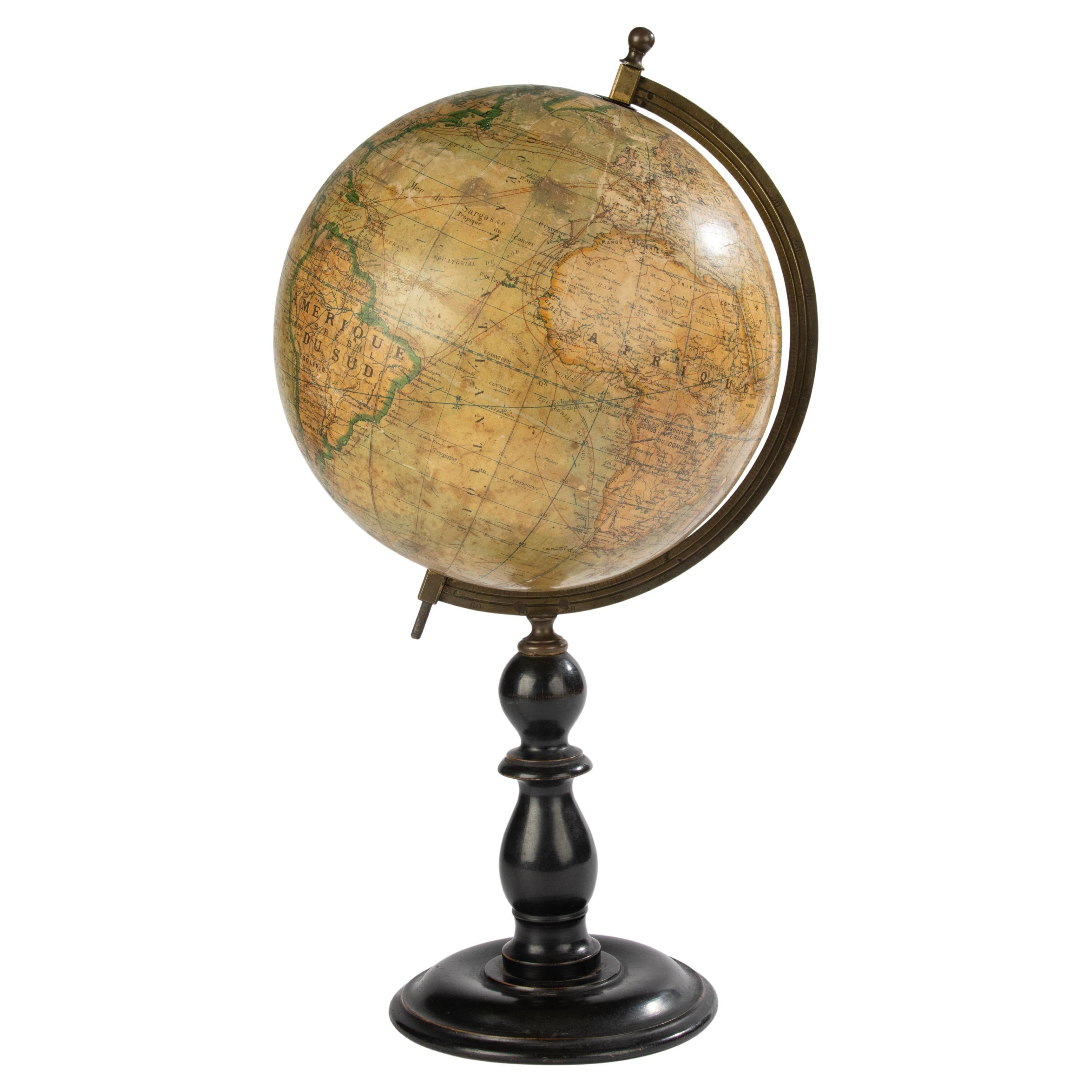
View AllTerrestrial Table Globe by Félix Delamarche, Paris, 1821
By Félix Delamarche
Located in Milano, IT
Terrestrial table globe
Félix Delamarche
Paris, 1821
It measures 20.47 in height, Ø max 14.17 in; the sphere Ø 9.44 in (h 52 cm x Ø max 36.5 cm; the sphere Ø 24 cm)
Wood, printed...
Category
Antique 1820s French Restauration Scientific Instruments
Materials
Metal
Celestial Table Globe, Charles-François Delamarche, Paris, 1791
By Charles Francois Delamarche
Located in Milano, IT
Celestial table globe
Charles-François Delamarche
Paris, 1791
It measures: 17.13 in in height, Ø max 27.7 in; the sphere Ø 7.09 in
(h 43.5 cm x Ø max 27.7 cm; the sphere Ø 18 cm).
W...
Category
Antique 1790s French Other Scientific Instruments
Materials
Metal
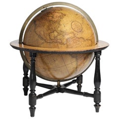
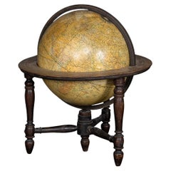
18-inch Globe, Cary's, London, 1840
By Cary’s
Located in Milano, IT
John and William Cary
Updated by George and John Cary
Terrestrial Globe
London, 1840
lb 22 (kg 10)
Slight surface abrasions due to use. A small crack on the horizon circle.
The globe rests in its original Dutch style stand with four supporting turned wood columns.
It measures 26 in in height x 23.6 in in diameter with the diameter of the sphere measuring 18 in; 66 cm in height x 60 cm in diameter with the diameter of the sphere measuring 45.72 cm.
The 18 inch...
Category
Antique 1840s English Early Victorian Globes
Materials
Paper, Wood
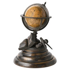
Miniature Terrestrial Globe Newton & Son London, Post 1833, Ante 1858
By Newton and Son
Located in Milano, IT
Miniature Terrestrial Globe
Newton & Son
London, post 1833, ante 1858
Paper, papier-mâché, bronze and wood
It measures: sphere diameter 2.95 in (7.6 cm); diameter of the wooden base 6.02 in (15.3 cm); height 8.36 in (21.24 cm).
Weight: 2,067 lb.
State of conservation: the globe still bears its original paint, but has various small gaps, abrasions and stains on the surface.
The globe is hinged with two pins at the meridian circle, which is in turn inserted perpendicular to the horizon circle; this is supported by four semi-arches connected at the bottom by a small goblet-shaped foot, resting on a wooden bell-shaped base.
Apart from the wooden base, the entire support structure is made of bronze; on the foot there are the scale reproductions of a compass, a telescope and an open book.
The sphere is made of papier-mâché and is covered with twelve printed paper gores.
In the North Pacific Ocean the globe bears a cartouche with the inscription (about 30% of the writing is illegible, but the missing parts can be easily integrated based on the rest):
NEWTON’S
New & Improved
TERRESTRIAL
Globe
Published by Newton & Son
66 Chancery Lane
LONDON
On the globe, much of central Africa is empty and the great lakes Tanganyika and Victoria are not marked (Europeans would begin to explore the area after 1858). Canada is called "British Territory" and Alaska "Russian Territory" (it would become part of the United States in 1867). Australia already bears its modern name (until 1829 it had been called New Holland) and its coasts are completely designed; Tasmania is listed as an island (Matthew Flinders circumnavigated it in 1798). The routes of Cook's various voyages are plotted; both the route followed by Biscoe in 1831 and the "Land of Enderby" which he discovered on the coast of Antarctica, south of Africa, are marked.
Bibliography
P. Van der Krogt, Old Globes...
Category
Antique 1840s English Early Victorian Maps
Materials
Bronze
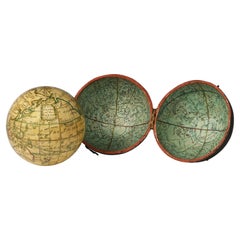
Pocket Globe, Nicholas Lane, London, post 1779
By Nicholas Lane
Located in Milano, IT
Pocket Globe
Nicholas Lane
London, post 1779
The globe is contained in its original case, which is covered in leather.
The sphere measures 2.75 in (6.9 cm) whereas the case measure...
Category
Antique 1780s English Other Models and Miniatures
Materials
Leather, Wood, Paper
Ptolemaic Armillary Sphere Charles-François Delamarche Paris, 1805-1810 Circa
By Charles Francois Delamarche
Located in Milano, IT
Charles-François Delamarche
Ptolemaic armillary sphere
Paris, circa 1805-1810
Wood and papier-mâché
covered with printed and partly hand-coloured paper
It measures 15.74” in height, ...
Category
Antique Early 1800s French Empire Scientific Instruments
Materials
Paper, Wood

You May Also Like
Terrestrial globe published by Ernst Schotte & co, Germany 1890.
Located in Milan, IT
Terrestrial globe in watercolored paper, fixed with an inclined axis through a small brass arm, mounted on a black turned fruit wood base. Published by Ernst Schotte & Co. Berlin, Ge...
Category
Antique Late 19th Century German Scientific Instruments
Materials
Brass
Antique 19th Century Miniature French Edition Globe by C. Abel-Klinger
By C. Abel-Klinger
Located in Philadelphia, PA
A fine antique French Edition miniature globe.
By C. Abel-Klinger.
On a turned wooden stand with an uncalibrated brass half meridian.
The globe is marked with an integral l...
Category
Antique 19th Century German Neoclassical Maps
Materials
Paper
Antique 19th Century Smiths Terrestrial Globe By George Philips & Son Ltd c.1890
By George Philip & Son
Located in Royal Tunbridge Wells, Kent
Antique 19th Century English terrestrial globe made by George Philips and Son. Set on a walnut stand. This piece makes a striking addition to any library or serves as a decorative ye...
Category
20th Century British Other Globes
Materials
Walnut
19th Century Terrestrial Globe - by Ikelmer Paris
By Ikelmer
Located in Casteren, Noord-Brabant
A beautiful antique globe, issued by the French maker Ikelmer Paris.
The globe was made around 1880-1890.
The globe is made of paper, the base is made of black lacquered wood.
The gl...
Category
Antique Late 19th Century French Belle Époque Globes
Materials
Wood, Paper
Library Terrestrial Globe On Stand, Late 19th Early 20th Century
Located in MARSEILLE, FR
Large terrestrial globe in papier maché and plaster, fixed in its wooden basket: the spindles are painted with the continents (decoratively), the complete meridian is in brass; the h...
Category
Antique Late 19th Century Italian Renaissance Scientific Instruments
Materials
Wood, Paper

19th Century Terrestrial Globe by G. Thomas, Editeur & Globe Maker, Paris, 1890s
By G. Thomas, Éditeur
Located in San Francisco, CA
Rare 19th century terrestrial globe by G. Thomas, Editeur & Globe Maker, Paris, circa 1890s
The globe sits atop a wooden stand and measures 4" diameter x 6.5" high.
The globe i...
Category
Antique Late 19th Century French Globes
Materials
Paper
More Ways To Browse
Terrestrial Globes
Zodiac Globe
Opera Glasses
Antique Barometer Thermometer
Mushroom Model
19th Century French Barometer
Antique Balancing Scales
Antique Vacuum
Antique Weight Scales
Antique Glass Tubes
Brass Barometers
Bronze Mortar
Antique Apparatus
Antique Avery
Anatomic Plaster
Antique Spectacles
Brass Display Stand
Curiosity Shop