1 of 7
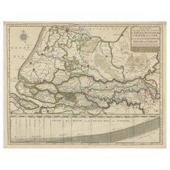
1750 Schaffhausen, Seutter, Large and Detailed Map Switzerland
$634.16List Price
About the Item
- Creator:Matthew Seutter (Artist)
- Dimensions:Height: 14.57 in (37 cm)Width: 16.93 in (43 cm)Depth: 0.04 in (1 mm)
- Style:Baroque (Of the Period)
- Materials and Techniques:
- Place of Origin:
- Period:1670-1679
- Date of Manufacture:1679
- Condition:Wear consistent with age and use.
- Seller Location:Norwich, GB
- Reference Number:1stDibs: LU7031234705412
Authenticity Guarantee
In the unlikely event there’s an issue with an item’s authenticity, contact us within 1 year for a full refund. DetailsMoney-Back Guarantee
If your item is not as described, is damaged in transit, or does not arrive, contact us within 7 days for a full refund. Details24-Hour Cancellation
You have a 24-hour grace period in which to reconsider your purchase, with no questions asked.Vetted Professional Sellers
Our world-class sellers must adhere to strict standards for service and quality, maintaining the integrity of our listings.Price-Match Guarantee
If you find that a seller listed the same item for a lower price elsewhere, we’ll match it.Trusted Global Delivery
Our best-in-class carrier network provides specialized shipping options worldwide, including custom delivery.You May Also Like
Antique Map of Northern Germany by M. Seutter, circa 1730
By Matthew Seutter
Located in Langweer, NL
Antique map titled 'Saxoniae Inferioris Circulus'. Old map of the northern part of Germany by M. Seutter. Covering the area of Lower Saxony, Mecklenburg-Vorpommern and Schleswig-Hols...
Category
Antique Mid-18th Century Maps
Materials
Paper

$568 Sale Price
20% Off
H 20.67 in W 24.61 in D 0.02 in
1859 Antique Swiss Panorama: Blackie's Detailed Map of Switzerland
Located in Langweer, NL
The "Antique Map of Switzerland" is a distinguished piece from 'The Imperial Atlas of Modern Geography', published in 1859 by the renowned cartographer W. G. Blackie. This map presen...
Category
Antique Mid-19th Century Maps
Materials
Paper
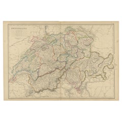
$210 Sale Price
30% Off
H 14.57 in W 21.26 in D 0.02 in
Detailed Original Antique Map of the Russian Empire in Asia, 1750
Located in Langweer, NL
Antique map titled 'Partie Orientale de l'Empire de Russie en Asie (..)'.
Detailed map of the Russian Empire in Asia.
Artists and Engravers: Gilles Robert de Vaugondy (1688-1766) was the head of a leading family of geographers in eighteenth century France. Gilles got his start when he jointly inherited the shop of Pierre-Moullart Sanson, grandson of the famous geographer Nicholas Sanson. The inheritance included the business, its stock of plates, and a roller press...
Category
Antique 1750s Maps
Materials
Paper
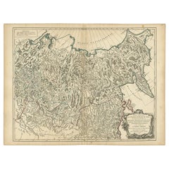
$568 Sale Price
20% Off
H 19.69 in W 25.99 in D 0 in
Antique Map of Greece by Seutter or Lotter, 'c.1740'
Located in Langweer, NL
Antique map titled 'Graecia pars Septentrionalis'. Original antique map of Greece, uncommon. Signed cum Gratia et Privil. S.R.I. Vicariatus (..)'. Published by Seutter or Lotter, cir...
Category
Antique Mid-18th Century Maps
Materials
Paper

$664 Sale Price
35% Off
H 20.28 in W 25.6 in D 0.02 in
Detailed Regional Map of the Gulf of Bengal and the Lower Ganges River, ca.1750
Located in Langweer, NL
Title of this original and rare antique map: Nouvelle Carte Du Royaume De Bengale
Mapmaker: Jacques-Nicolas Bellin (1703-1772).
He was among the most important mapmakers of the eighteenth century. In 1721, at only the age of 18, he was appointed Hydrographer to the French Navy. In August 1741, he became the first Ingénieur de la Marine of the Dépôt des cartes...
Category
Antique 1750s Maps
Materials
Paper
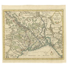
$606 Sale Price
20% Off
H 11 in W 13.5 in D 0.02 in
Large and Detailed Map of the Russian Empire in Asia, ca.1780
Located in Langweer, NL
Description: Antique map titled 'Bowles's New Pocket Map of the East Part of the Russian Empire in Asia'. Large and detailed map of the Russian Empire in Asia. Source unknown, to be determined.
Artists and Engravers: Made by 'Thomas & Carington Bowles' after 'D'Anville'. Thomas Bowles, born around 1712, was map publisher and seller in London...
Category
Antique 1780s Maps
Materials
Paper
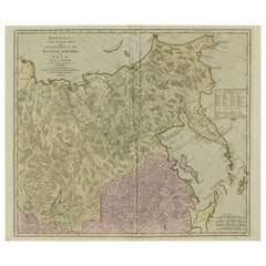
$818 Sale Price
20% Off
H 19.61 in W 23.31 in D 0 in
Detailed Map of Dutch Rivers, with the Rhine, Maas, de Merwe en de Lek, C.1750
Located in Langweer, NL
Antique map titled 'Kaart van den Loop der Rivieren de Rhyn, de Maas, de Waal, de Merwe en de Lek, door de Provincien van Gelderland, Holland en Utrecht'.
...
Category
Antique 1750s Maps
Materials
Paper
$539 Sale Price
20% Off
H 16.15 in W 20.48 in D 0 in
Antique Map of Tartary and Northeast Asia, c.1750
Located in Langweer, NL
Antique map titled 'Carte de la tartarie occidentale'. An interesting map of Tartary and northeast Asia, from Lake Baykal, Partie du Siberia in the north, Pays des Kalkas at the cent...
Category
Antique 18th Century Maps
Materials
Paper

Antique Print of the Rhine Falls, near Schaffhausen, Switzerland
Located in Langweer, NL
Antique print titled 'Der Rheinfall, bei Schaffhausen'. View of the Rhine Falls, a waterfall located in Switzerland and the most powerful waterfall in Europe. The falls are located o...
Category
Antique Late 19th Century Prints
Materials
Paper
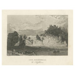
$144 Sale Price
20% Off
H 5.79 in W 7.17 in D 0.02 in
Swiss Splendor: Antique Map of Switzerland and Its Cantons, 1852
Located in Langweer, NL
The antique map titled 'Carte de la Suisse' is an attractive map of Switzerland. Here are the key details and features of the map:
1. **Geographic Coverage**:
- The map provides comprehensive coverage of Switzerland, depicting the entire country.
- It showcases the division of Switzerland by Cantons, including regions from Vaud to Grisons.
- Additionally, the map includes parts of adjacent countries, such as France, Germany, and Italy, providing context for Switzerland's geographical location.
2. **Cartographic Details**:
- The map offers detailed cartographic information, including the delineation of geographic features, rivers, mountains, and the names of Cantons and towns.
- It presents a clear and informative representation of Switzerland's topography.
3. **Origin**:
- This map originates from Maison Basset's 1852 edition of 'Atlas Illustre Destine a l'enseignement de la Geographie elementaire,' indicating its use for educational purposes, particularly in the teaching of geography.
4. **Educational Significance**:
- As part of an educational atlas, the map likely played a role in instructing students about the geography of Switzerland and its political subdivisions.
- It may have been employed as a visual aid to enhance students' understanding of Switzerland's Cantonal divisions.
5. **Aesthetic Appeal**:
- The map is described as attractive, suggesting that it possesses not only educational value but also visual appeal.
- Maps of this era often featured decorative elements that added to their aesthetic charm.
6. **Historical and Geopolitical Significance**:
- Switzerland's unique position in Europe, as a country surrounded...
Category
Antique Mid-19th Century Maps
Materials
Paper
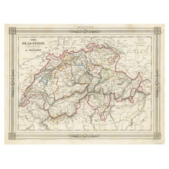
$134 Sale Price
20% Off
H 10.12 in W 13.39 in D 0.02 in
Recently Viewed
View AllMore Ways To Browse
Pomegranate Glass
Qing Dynasty Green
Qing Dynasty Snuff Bottle
Rabbit China
Raoul Guys
Realistic Animal Sculpture
Reclining Buddha
Record Holder
Rectangular Tilt Top
Reh Kennedy
Renaissance Cassone
Renaissance Commode Italian
Ring Cabinet Pull
Robert Kuo Crystal
Robert Mouseman Thompson
Robert Mouseman
Rococo Vanity
Roman Helmet