Items Similar to 17th Century Lithograph Framed Map of Spain


Want more images or videos?
Request additional images or videos from the seller
1 of 7
17th Century Lithograph Framed Map of Spain
$1,820
£1,374.65
€1,588.70
CA$2,552.83
A$2,839.40
CHF 1,486.08
MX$34,631.33
NOK 18,673.16
SEK 17,564.51
DKK 11,858.13
About the Item
In giltwood frame, dated 1652.
- Dimensions:Height: 20.5 in (52.07 cm)Width: 25.5 in (64.77 cm)Depth: 0.5 in (1.27 cm)
- Style:Baroque (Of the Period)
- Materials and Techniques:
- Place of Origin:
- Period:
- Date of Manufacture:circa 1652 and Later Frame
- Condition:Wear consistent with age and use.
- Seller Location:Atlanta, GA
- Reference Number:Seller: R56551stDibs: LU82701146076
About the Seller
5.0
Vetted Professional Seller
Every seller passes strict standards for authenticity and reliability
Established in 1993
1stDibs seller since 2007
281 sales on 1stDibs
Typical response time: <1 hour
- ShippingRetrieving quote...Shipping from: Atlanta, GA
- Return Policy
Authenticity Guarantee
In the unlikely event there’s an issue with an item’s authenticity, contact us within 1 year for a full refund. DetailsMoney-Back Guarantee
If your item is not as described, is damaged in transit, or does not arrive, contact us within 7 days for a full refund. Details24-Hour Cancellation
You have a 24-hour grace period in which to reconsider your purchase, with no questions asked.Vetted Professional Sellers
Our world-class sellers must adhere to strict standards for service and quality, maintaining the integrity of our listings.Price-Match Guarantee
If you find that a seller listed the same item for a lower price elsewhere, we’ll match it.Trusted Global Delivery
Our best-in-class carrier network provides specialized shipping options worldwide, including custom delivery.More From This Seller
View AllMid-18th Century Engraving in a Mid-19th Century Giltwood Frame
Located in Atlanta, GA
displaying a king or nobleman seated on a throne
Category
Antique Early 18th Century French Louis XIV Prints

Italian, Venezia, Giltwood Framed Engraving, "Cavallerriza Di Venezia", ca. 1825
Located in Atlanta, GA
highly specialized subject of a riding arena/academy in Venice, Italy, matted in a period giltwood frame
Category
Antique 1820s Italian Neoclassical Prints
Materials
Giltwood, Paper

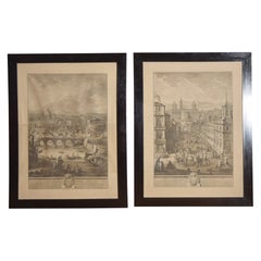
Pair Italian Large Framed Architectural Engravings, Views of Rome, early 19thc
Located in Atlanta, GA
each large engraving framed in period ebonized frame, the scenes depicting Roman views with architecture and figures
Category
Antique Early 19th Century Italian Neoclassical Prints
Materials
Paper
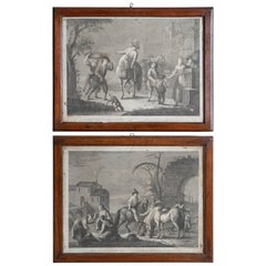
Pair French Engravings of Genre Scenes in Walnut Frames, mid 18th century
Located in Atlanta, GA
Each engraving depicting a typical street and genre scene, respectively, both in antique walnut frames
Category
Antique Mid-18th Century French Rococo Prints
Materials
Paper
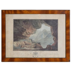
French Neoclassic Engraving, Vue de La Caverne du Dragon, early 19th century
Located in Atlanta, GA
The hand colored engraving by Descourtis depicting a true cave in the Orange region of France with curious admirers with a dog and a soldier, in a period walnut and ebonized frame
Category
Antique Early 1800s French Neoclassical Prints
Materials
Walnut
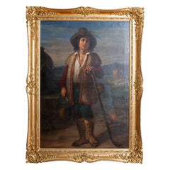
Italian, Rome/Naples, Oil on Canvas, “Ciociara”, Original Frame, ca. 1875
Located in Atlanta, GA
Beautifully painted oil on canvas in its period and original giltwood frame, the canvas relined and the frame completely restored. Of note in the painting are the peacock feather in...
Category
Antique 1870s Italian High Victorian Paintings
Materials
Giltwood, Paint
You May Also Like
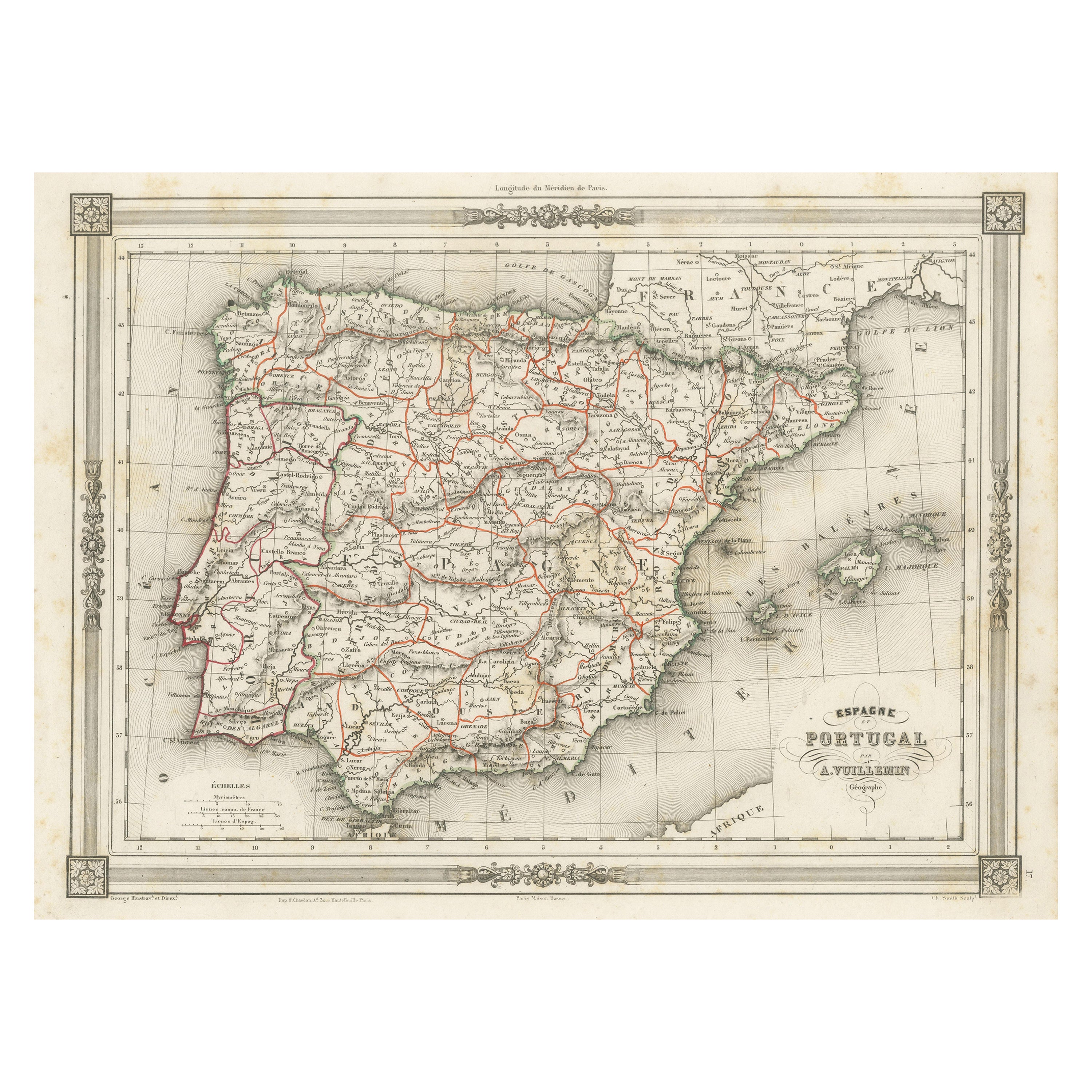
Antique Map of Spain and Portugal, with Frame Style Border
Located in Langweer, NL
Antique map titled 'Espagne et Portugal'. Attractive map of Spain and Portugal. The map covers all of Spain and Portugal from France to the Mediterranean Sea and includes the Baleari...
Category
Antique Mid-19th Century Maps
Materials
Paper
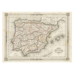
$114 Sale Price
20% Off
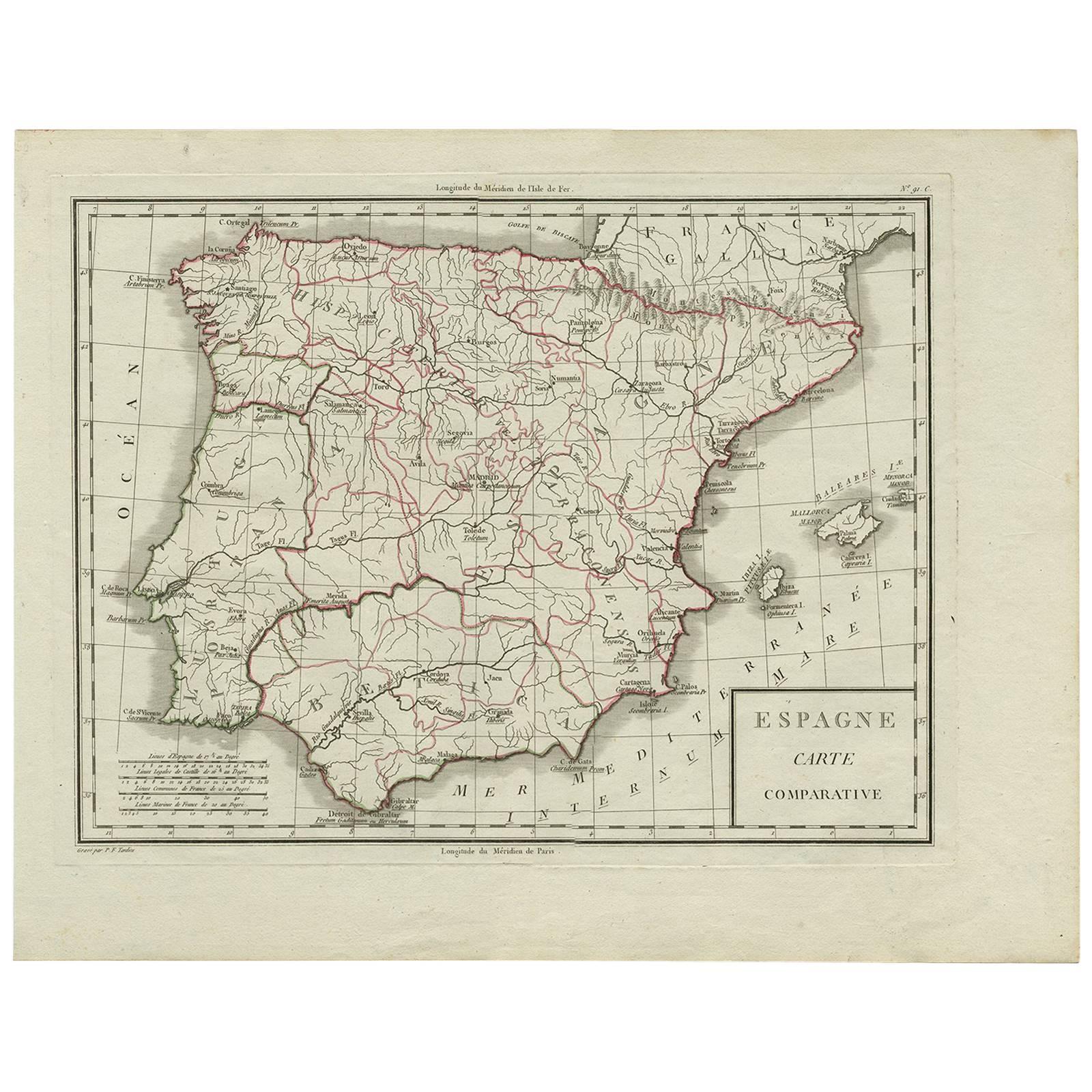
Antique Map of Spain by P.F. Tardieu, circa 1798
By Pierre François Tardieu
Located in Langweer, NL
Antique map titled 'Espagne carte comparative', showing river systems, the modern states of Spain and Portugal and the Roman provinces of Lusitania, Beatica & Hispania Tarraconensis....
Category
Antique Late 18th Century Maps
Materials
Paper
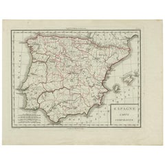
$166 Sale Price
20% Off
After Johann B. Homann (1664-1724) - 19th C, General Map of Spain and Portugal
Located in Corsham, GB
General map of Spain and Portugal divided into its current provinces by D.T. Lopez, newly drawn by F. L. G. in Nuremberg at the Heret of Homann, 1782. A double-page engraved map with...
Category
19th Century More Prints
Materials
Engraving

Antique Map of Spain and Portugal by Tardieu, circa 1795
Located in Langweer, NL
The image is an antique map titled "Hispanie Betique et Lusitanie", which depicts the Iberian Peninsula during the Roman times, highlighting the provinces of Hispania Baetica (Betiqu...
Category
Antique Late 18th Century Maps
Materials
Paper

$238 Sale Price
20% Off
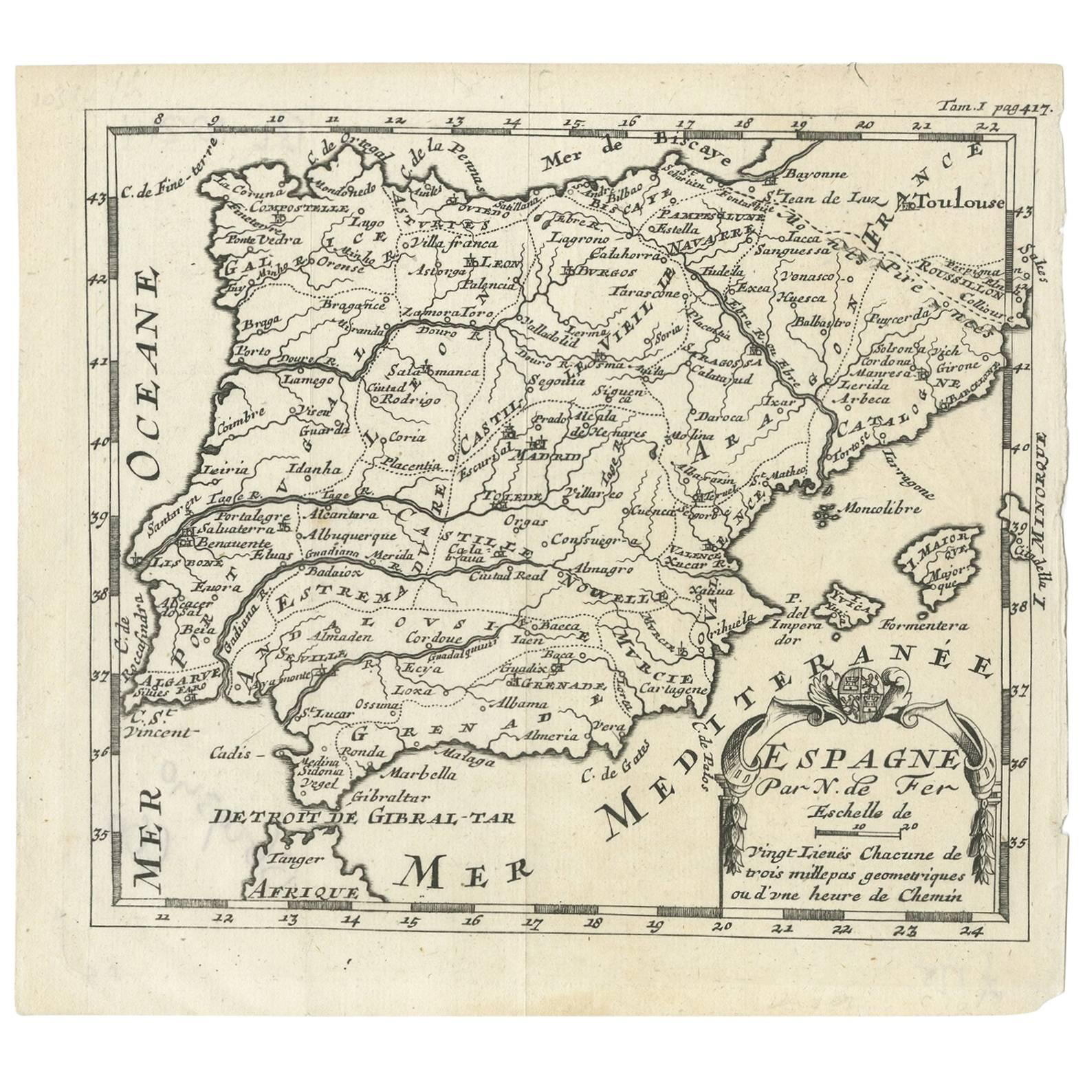
Antique Map of Spain by N. de Fer, circa 1700
Located in Langweer, NL
Antique map of Spain and Portugal with a title cartouche. Nicolas de Fer was the youngest son of the Paris printer and publisher Antoine de Fer. At the ...
Category
Antique Early 18th Century Maps
Materials
Paper
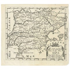
$152 Sale Price
20% Off
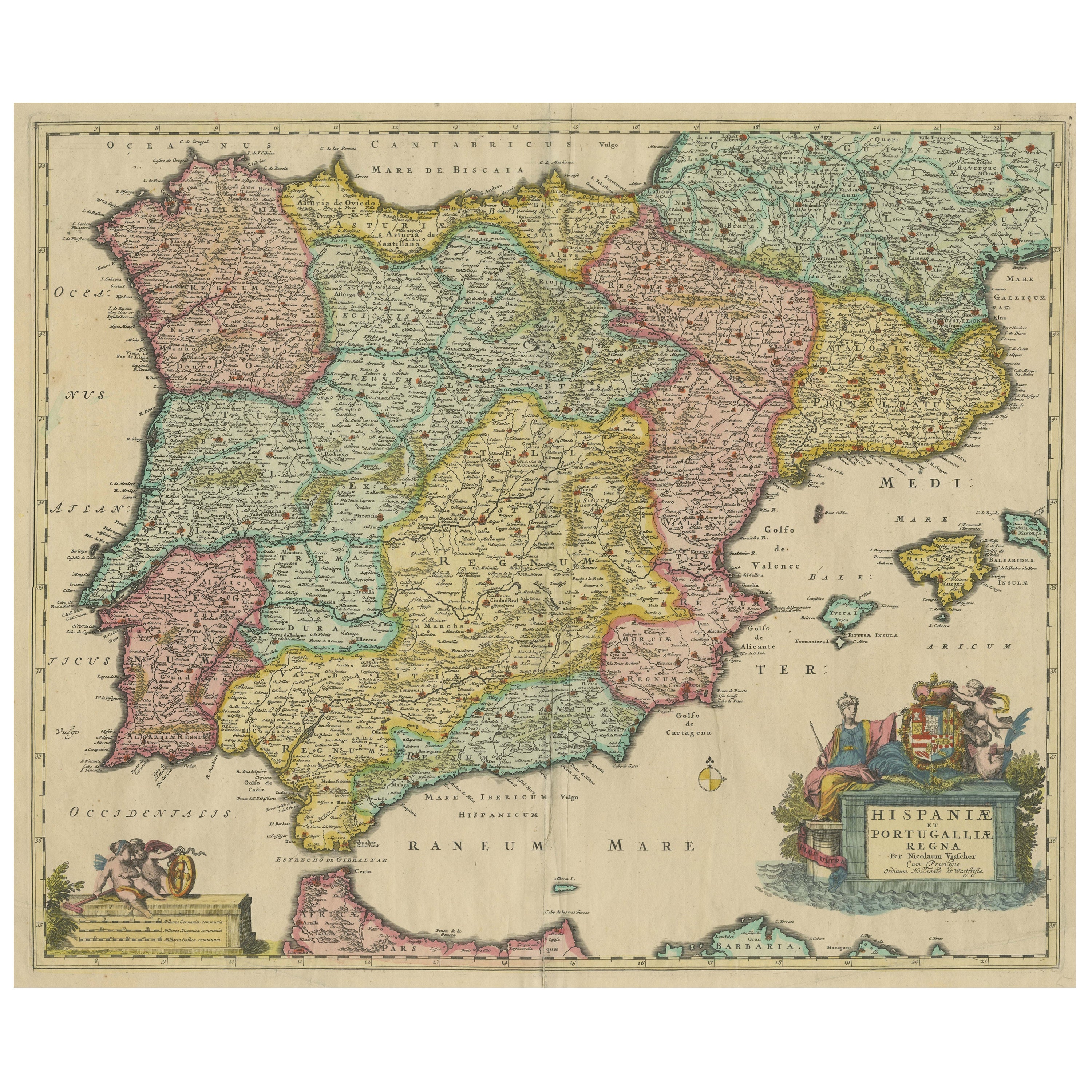
Antique Map of the Iberian Peninsula with two decorative Cartouches
Located in Langweer, NL
Antique map titled 'Hispaniae et Portugalliae Regna'. Original old map of the Iberian peninsula showing Spain, Portugal and the Balearic Islands. Two beautiful cartouches with severa...
Category
Antique Late 17th Century Maps
Materials
Paper
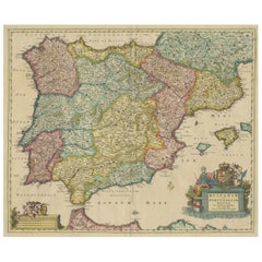
$1,420 Sale Price
20% Off
More Ways To Browse
Birds In Flight Wall Art
Gustave Dore
Fruit Prints Set
Theo Van Doesburg
Antique Bat Print
Antique Greek Costume
Monkey Engravings
Moth Collection
Chile Antique Prints
K J Wood
Paul Colin Josephine Baker
Pinto Paris
Antique Ice Skates
Commodore Perry
Picasso Sala Gaspar
Surgical Instruments
Antique Astrolabe
Cowes Yacht