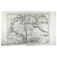
Bellin, map, Hudson Bay, Canada, James Bay, Labrador
View Similar Items


Want more images or videos?
Request additional images or videos from the seller
1 of 7
Bellin, map, Hudson Bay, Canada, James Bay, Labrador
About the Item
- Dimensions:Height: 24.8 in (63 cm)Width: 23.8 in (60.46 cm)Depth: 0.1 in (2.54 mm)
- Materials and Techniques:
- Place of Origin:
- Period:
- Date of Manufacture:1880
- Condition:Wear consistent with age and use.
- Seller Location:Norwich, GB
- Reference Number:1stDibs: LU7031230733022
About the Seller
No Reviews Yet
Vetted Professional Seller
Every seller passes strict standards for authenticity and reliability
Established in 1992
1stDibs seller since 2022
10 sales on 1stDibs
Authenticity Guarantee
In the unlikely event there’s an issue with an item’s authenticity, contact us within 1 year for a full refund. DetailsMoney-Back Guarantee
If your item is not as described, is damaged in transit, or does not arrive, contact us within 7 days for a full refund. Details24-Hour Cancellation
You have a 24-hour grace period in which to reconsider your purchase, with no questions asked.Vetted Professional Sellers
Our world-class sellers must adhere to strict standards for service and quality, maintaining the integrity of our listings.Price-Match Guarantee
If you find that a seller listed the same item for a lower price elsewhere, we’ll match it.Trusted Global Delivery
Our best-in-class carrier network provides specialized shipping options worldwide, including custom delivery.More From This Seller
View All1750 Schaffhausen, Seutter, Large and Detailed Map Switzerland
By Matthew Seutter
Located in Norwich, GB
Sandrart Joachim, von (1606-1688)
Effigies antiquae Romae. redacta a Pyrrho Ligorio Romano, per XIIII Regiones, in quas Urbem divisit Imp. Caesar August.
Nuremberg, Germany, pu...
Category
Antique 1670s Italian Baroque Prints
Materials
Paper
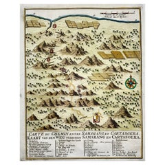
Map of Indonesia, Semarang, Kartasoera, Soerabaya by Schley
By Jakob van der Schley
Located in Norwich, GB
'Carte du Chemin entre Samarang et Cartasoera, kaart van den weg tusschen Samarang en Cartasoera'
Map of the Road between Semarang and Kartasura by Van Schley.
Published 1763.
...
Category
Antique 1760s Indonesian Georgian Prints
Materials
Paper
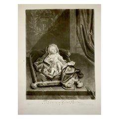
Godfrey Kneller After J. Smith, Portrait of James Stuart, the Old Pretender
By Sir Godfrey Kneller
Located in Norwich, GB
The Prince of Great Britain (Portrait of James Stuart, the Old Pretender)
G Kneller ad vivum pinx:', 'I Smith fecit'.
Published by I Smith at ye go...
Category
Antique 1680s English George I Prints
Materials
Paper
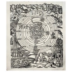
1517 Farming Calendar, Master of the Grüninger Workshop, Master Woodcut
By Albrecht Dürer
Located in Norwich, GB
Original from 1515
A pivotal and iconic calendar woodcut from 1517 and first used in the 1502 of Sebastian Brandt’s edition of the works of Vergil.
The four books of The Georgi...
Category
Antique 16th Century Prints
Materials
Paper
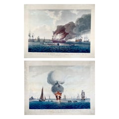
1797 Set of 2 Large Aquatints, Maritime, Explosion of the 'HMS' Boyne
By John William Edy
Located in Norwich, GB
On offer two superb and large aquatints (with original hand color) depicting the “Explosion on, and Sinking of Her Majesty’s Ship BOYNE”
Plate 1. “View of His Majesty's Ship Boyne...
Category
Antique 1790s British Georgian Prints
Materials
Paper
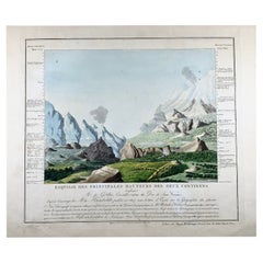
1813 Joh. W. Von Goethe & Alex. Von Humboldt; Comparative View of Mountains
Located in Norwich, GB
Esquisse des principales hauteurs des deux continens dressée par Mr. de Göthe,... d'après l'ouvrage de Mr. de Humboldt, publié en 1807 sous le titre d'Essai sur la géographie des plantes
Goethe, Johann Wolfgang von (1749-1832). Cartographer
Using information from: Humboldt, Alexander von (1769-1859)
32 x 27 cm on a leaf measuring 47 x 55 cm.
Extremely rare example of Johann Wolfgang von Goethe’s comparative chart to depict the relative height of mountains, thus defining a cartographic style that would flourish throughout the remainder of the 19th century.
This map is extremely scarce. It was issued and sold independently in Paris, 1813.
Beginning in 1805, Goethe gave lectures on natural sciences to a group of Weimar women on Wednesday mornings. The audience included the Duchess Luise, Schiller's widow Charlotte and her sister Caroline von Wolzogen. Here Goethe used his image of heights on April 1, 1807 for the first time. A copy was sent to Alexander von Humboldt...
Category
Antique 1810s Biedermeier Prints
Materials
Paper
You May Also Like
Antique Map of Siberia by Bellin, 1754
Located in Langweer, NL
Antique map titled 'Carte de la Siberie'. Detailed map of Siberia, extending from the White Sea and the Caspian Sea in the west to Irkuckoi Province, Jakutky on the Lena River and regions just to the east. Centered on the Jenisi River. Originates from Prévost's 'Histoire Générale des Voyages'. Artists and Engravers: Jacques-Nicolas Bellin (1703-1772) was among the most important mapmakers of the eighteenth century. In 1721, at age 18, he was appointed hydrographer (chief cartographer) to the French Navy. In August 1741, he became the first Ingénieur de la Marine of the Depot des cartes...
Category
Antique 18th Century Maps
Materials
Paper

$324 Sale Price
20% Off
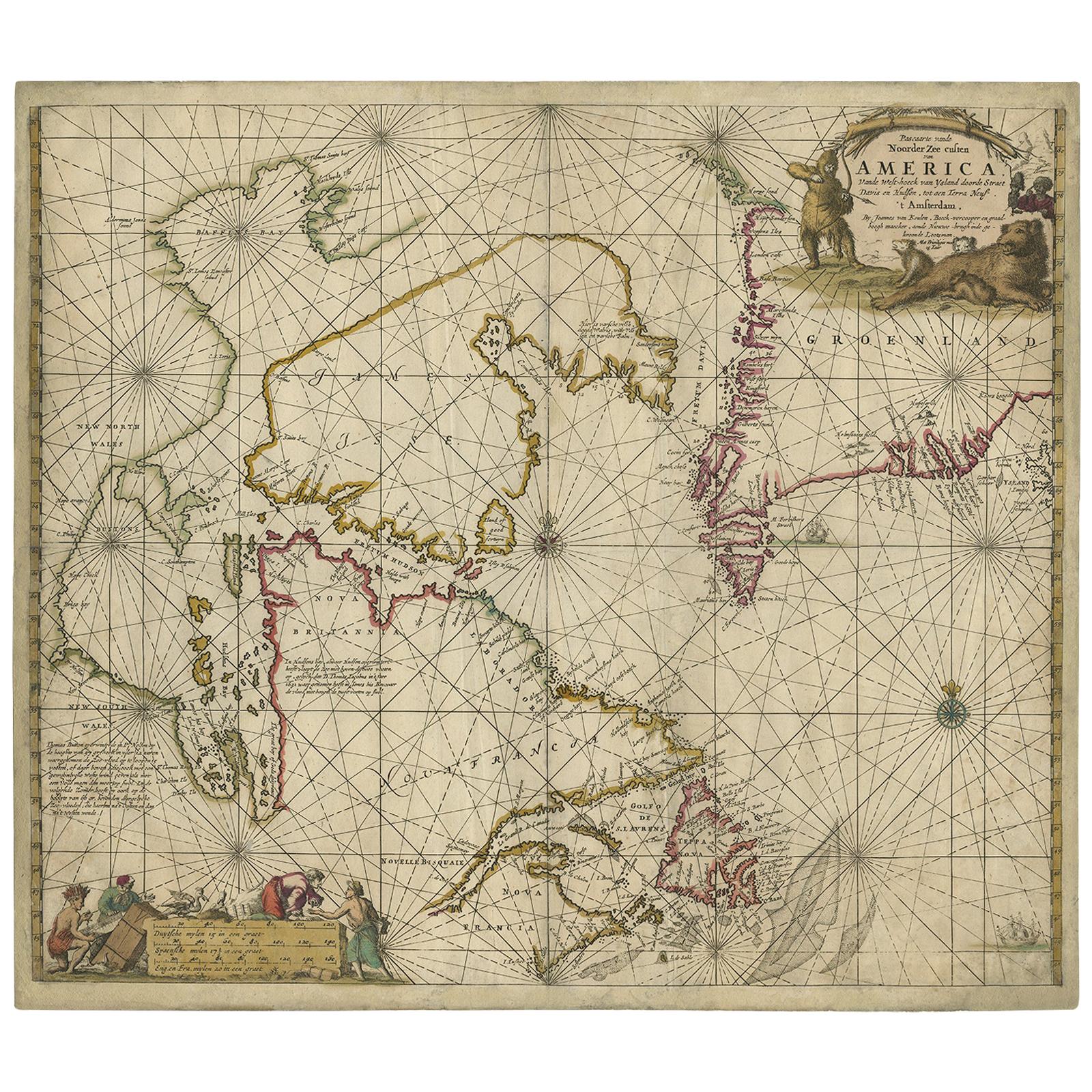
Antique Sea Chart of Hudson Bay and Arctic Canada by Van Keulen, circa 1681
Located in Langweer, NL
Antique map titled 'Pascaarte vande Noorderzee Custen van America (..)'. Sea chart of Hudson Bay and Arctic Canada. Compass roses, loxodromic lines, and ships decorate the oceans and...
Category
Antique Late 17th Century Maps
Materials
Paper
Antique Map of Japan by J.N. Bellin, 1752
Located in Langweer, NL
Bellin's wonderfully detailed map of Japan from the atlas of Prevost d'Exiles' influential collection of travel narratives, Histoire Generale des Voyages. Considered the best general...
Category
Antique Mid-18th Century Maps
Materials
Paper

$426 Sale Price
20% Off
Antique Map of Eastern Siberia by Bellin '1768'
Located in Langweer, NL
Antique map titled 'Suite de la Carte de la Siberie et le Pays de Kamtchatka'. Original antique map of the eastern portion of Siberia, centered on eastern Russia and the Mer d'Ochozk (Sea of Okhotsk) showing the Kamchatka Peninsula and I. de Beringe and I. Sagalin. The map shows the tracks of Russian ships...
Category
Antique Mid-18th Century Maps
Materials
Paper

$278 Sale Price
20% Off
Antique Map of the Arabian Peninsula by Bellin 'c.1740'
Located in Langweer, NL
Antique map titled 'Carte de la Coste d'Arabie, Mer Rouge et Golfe de Perse'. Original antique map of the Arabian Peninsula, labes both Mecca and Med...
Category
Antique Mid-18th Century Maps
Materials
Paper

$463 Sale Price
20% Off
Antique Map of Boulogne-sur-Mer by Bellin '1764'
Located in Langweer, NL
Antique map titled 'Plan de la Ville de Boulogne'. Original antique map of Boulogne-sur-Mer, France. This map originates from 'Le petit atlas maritime: recueil de cartes et plans des...
Category
Antique Mid-18th Century Maps
Materials
Paper

$139 Sale Price
20% Off