Items Similar to Botanical Map by A.K. Johnston – Global Plant Distribution Chart 1852


Want more images or videos?
Request additional images or videos from the seller
1 of 10
Botanical Map by A.K. Johnston – Global Plant Distribution Chart 1852
$312.87per item
£231.63per item
€260per item
CA$433.19per item
A$472.94per item
CHF 247.94per item
MX$5,744.04per item
NOK 3,096.41per item
SEK 2,923.84per item
DKK 1,979.44per item
Quantity
About the Item
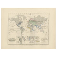
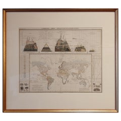
Botanical Map by A.K. Johnston – Global Plant Distribution Chart 1852
This remarkable antique chart titled "The Distribution of the Most Important Trees, Shrubs, Grains, & Fruits According to Zones of Climate & Moisture" was created by Alexander Keith Johnston and published in 1852 by William Blackwood & Sons, Edinburgh and London. It is Plate 15 from Johnston’s revolutionary *Physical Atlas of Natural Phenomena*, a foundational work in scientific cartography.
This thematic map combines botanical geography and climatology to illustrate how vegetation and agricultural crops are distributed across the globe according to climatic zones and moisture levels. Zones such as the "Climate of the Tropics," "European & Tropical," and "Northern Zone of Perpetual Ice and Snow" are color-coded and labeled with the dominant plants, fruits, or grains associated with each area.
The map meticulously annotates where particular species grow best: bananas and sugarcane in equatorial regions, wheat and apples in temperate zones, palms and spice trees in the tropics, and mosses and berries in the Arctic. The influence of rainfall and elevation is also emphasized, providing a multidimensional understanding of global botanical ecology as understood in the 19th century.
Beneath the main map is a stunning cross-sectional diagram titled "Distribution of Plants in a Vertical Direction," illustrating mountain ecosystems from the Rocky Mountains and Andes to the Himalayas and Alps. As the elevation rises, the vegetation zones change—from tropical palms at the base to alpine mosses and lichens near the peaks—offering a visual summary of how altitude affects plant distribution as dramatically as latitude.
Alexander Keith Johnston (1804–1871), a leading figure in Victorian science and cartography, was Geographer in Ordinary to Queen Victoria in Scotland. His work revolutionized the use of maps to present scientific data, and his *Physical Atlas* is still admired for its clarity, elegance, and educational ambition.
This chart is a must-have for collectors of botanical history, early climatology, or decorative scientific illustrations. Its blend of empirical data and visual storytelling is both informative and visually compelling.
Condition and framing tips:
Very good antique condition with minor age toning and a clean printed surface. A striking plate for display, best framed in walnut or gold with a warm ivory mat to highlight the earthy tones and detailed illustrations. Ideal for a library, conservatory, or academic interior.
- Dimensions:Height: 10.79 in (27.4 cm)Width: 13.59 in (34.5 cm)Depth: 0.01 in (0.2 mm)
- Materials and Techniques:
- Place of Origin:
- Period:
- Date of Manufacture:1852
- Condition:Very good condition. Light overall toning near the margins. The paper remains strong and well-preserved. Folding line as issued.
- Seller Location:Langweer, NL
- Reference Number:Seller: BG-13207-151stDibs: LU3054345393502
About the Seller
5.0
Recognized Seller
These prestigious sellers are industry leaders and represent the highest echelon for item quality and design.
Platinum Seller
Premium sellers with a 4.7+ rating and 24-hour response times
Established in 2009
1stDibs seller since 2017
2,641 sales on 1stDibs
Typical response time: <1 hour
- ShippingRetrieving quote...Shipping from: Langweer, Netherlands
- Return Policy
Authenticity Guarantee
In the unlikely event there’s an issue with an item’s authenticity, contact us within 1 year for a full refund. DetailsMoney-Back Guarantee
If your item is not as described, is damaged in transit, or does not arrive, contact us within 7 days for a full refund. Details24-Hour Cancellation
You have a 24-hour grace period in which to reconsider your purchase, with no questions asked.Vetted Professional Sellers
Our world-class sellers must adhere to strict standards for service and quality, maintaining the integrity of our listings.Price-Match Guarantee
If you find that a seller listed the same item for a lower price elsewhere, we’ll match it.Trusted Global Delivery
Our best-in-class carrier network provides specialized shipping options worldwide, including custom delivery.More From This Seller
View AllAntique Map Showing the Distribution of Plants by Johnston, '1850'
Located in Langweer, NL
Antique map titled 'Geographical Distribution of Plants'. Original antique map showing the distribution of plants. This map originates from 'The Physical Atlas of Natural Phenomena' ...
Category
Antique Mid-19th Century Maps
Materials
Paper

$192 Sale Price
20% Off
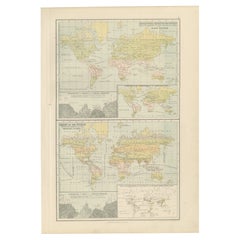
Antique Map of the World Showing the Distribution of Plants and Minerals, 1872
Located in Langweer, NL
Antique map titled 'Johnson's World showing the distribution of the Characteristic Forest Trees (..)'. Original world map showing the distribution o...
Category
Antique Late 19th Century Maps
Materials
Paper

$192 Sale Price
20% Off
Antique Map Showing the Distribution of Plants by Johnston '1850'
Located in Langweer, NL
Antique map titled 'Geographical plants which are used as food for man'. Original antique map showing the distribution of plants. This map originates from 'The Physical Atlas of Natu...
Category
Antique Mid-19th Century Maps
Materials
Paper
$192 Sale Price
20% Off
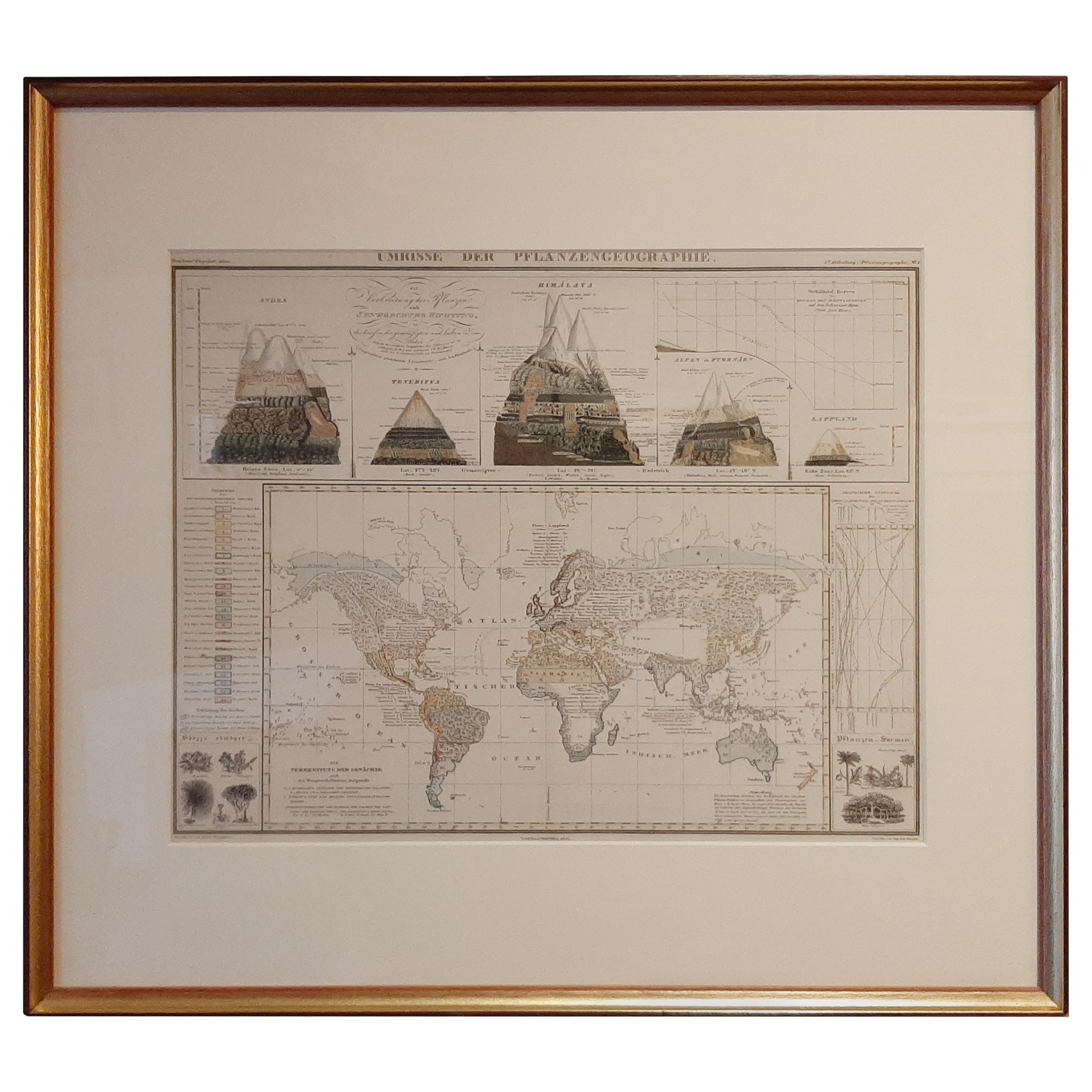
Antique Map of the Distribution of Vegetation throughout the World '1851'
Located in Langweer, NL
Antique map titled 'Umrisse der Pflanzengeographie'. Original antique map showing the distribution of vegetation throughout the world. Five drawings above the map show the vegetation...
Category
Antique Mid-19th Century Maps
Materials
Paper
$722 Sale Price
20% Off
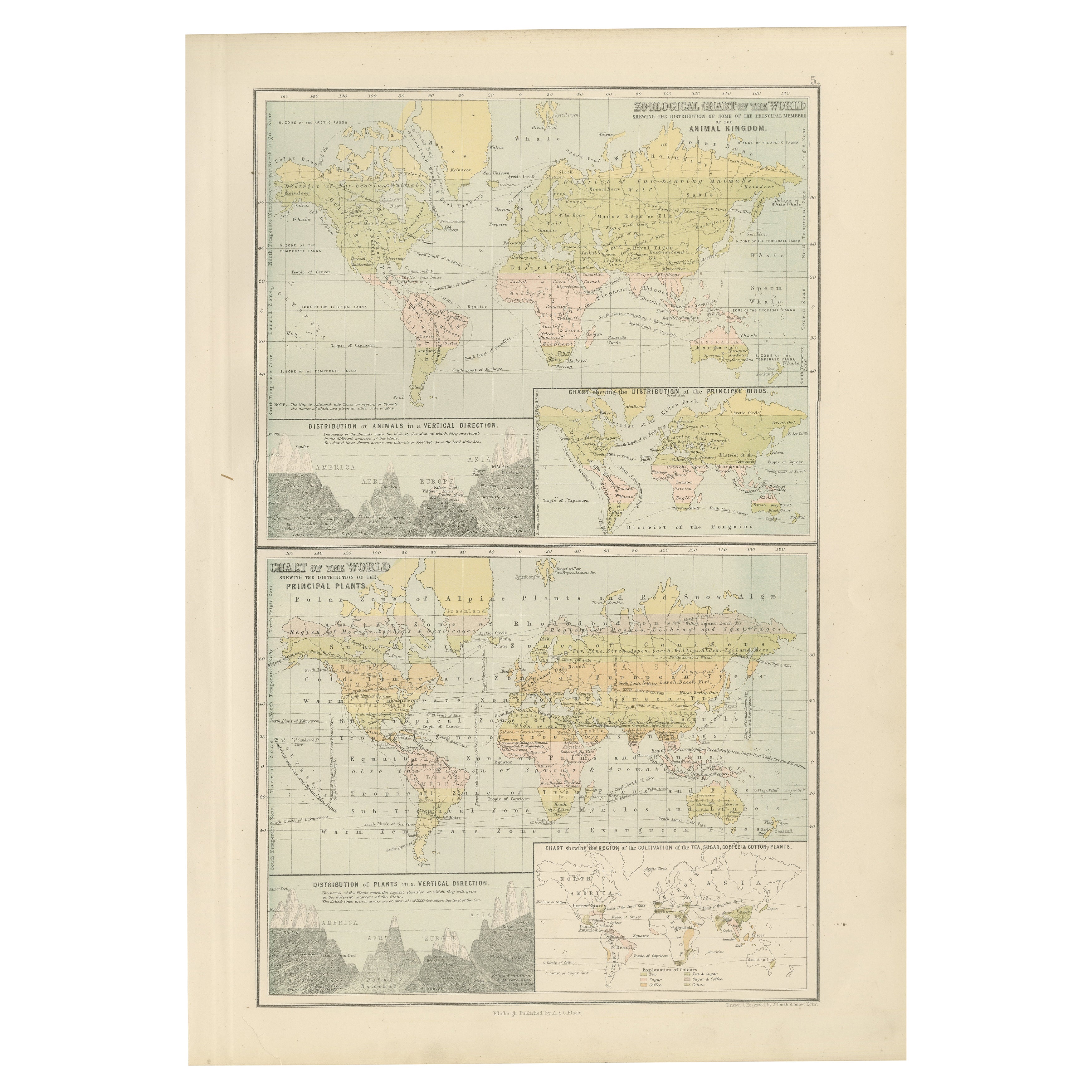
Antique Zoological and Botanical Chart of the World – Decorative Map, 1884
Located in Langweer, NL
Antique Zoological and Botanical Charts of the World – Black’s Atlas, 1884
This double plate from the New and Revised Edition of Black’s General Atlas of the World, published in Edi...
Category
Antique 1880s Scottish Maps
Materials
Paper
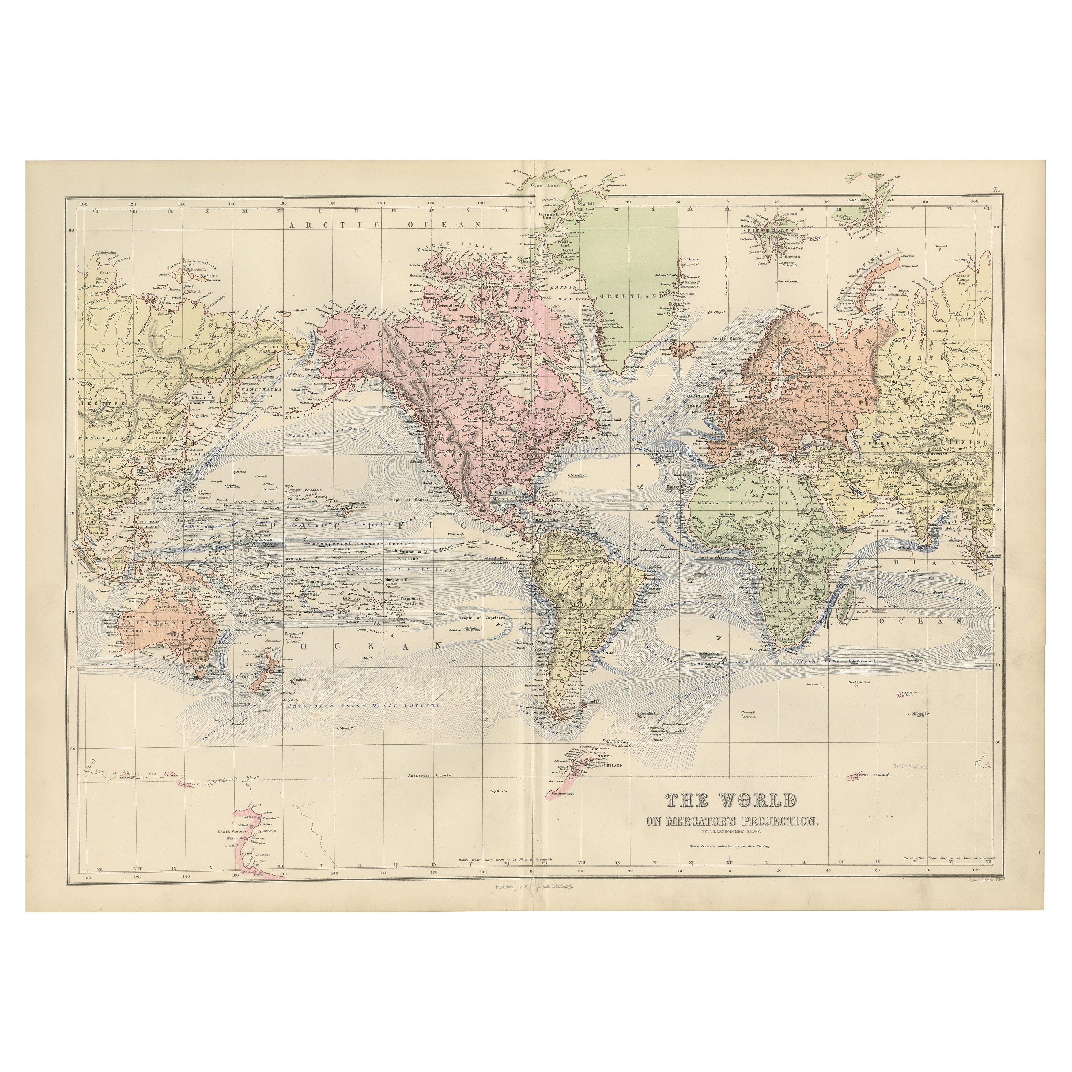
1884 Antique Decorative World Map – Mercator Projection, Victorian Era Print
Located in Langweer, NL
Antique World Map on Mercator’s Projection – Black’s Atlas, 1884
This finely engraved and colored map, titled The World on Mercator’s Projection, was published in the New and Revise...
Category
Antique 1880s Scottish Maps
Materials
Paper

You May Also Like
Original Antique Map of The World by Dower, circa 1835
Located in St Annes, Lancashire
Nice map of the World
Drawn and engraved by J.Dower
Published by Orr & Smith. C.1835
Unframed.
Free shipping
Category
Antique 1830s English Maps
Materials
Paper

1864 Original illustrated planisphere - World Map - Geography
Located in PARIS, FR
Immerse yourself in the epic journey of the past with the Illustrated Historical Planisphere of 1864 by Charpentier! 🗺️ This cartographic treasure transports you through the intrica...
Category
1860s Prints and Multiples
Materials
Linen, Lithograph, Paper

Original Antique Map of The World by Thomas Clerk, 1817
Located in St Annes, Lancashire
Great map of The Eastern and Western Hemispheres
On 2 sheets
Copper-plate engraving
Drawn and engraved by Thomas Clerk, Edinburgh.
Published by Mackenzie And Dent, 1817
...
Category
Antique 1810s English Maps
Materials
Paper

Original Antique Map of The Western Hemisphere by Dower, circa 1835
Located in St Annes, Lancashire
Nice map of the Western Hemisphere
Drawn and engraved by J.Dower
Published by Orr & Smith. C.1835
Unframed.
Free shipping
Category
Antique 1830s English Maps
Materials
Paper

Large Original Antique Map of The World, Fullarton, C.1870
Located in St Annes, Lancashire
Great map of the World. Showing both hemispheres
From the celebrated Royal Illustrated Atlas
Lithograph. Original color.
Published by Fullarton, Edinburgh, C.1870
Unframed.
Rep...
Category
Antique 1870s Scottish Maps
Materials
Paper

John Thomson (1777-1840) - 1830 Map Engraving, Chart of the World
By John Thomson
Located in Corsham, GB
A fine engraved map of the world on Mercator's projection, from the second edition of John Thomson's 'New General Atlas' published in 1830. On paper.
Category
Early 19th Century More Prints
Materials
Engraving
$316 Sale Price
20% Off
More Ways To Browse
Brutalist Horse
Brutalist Zodiac
Buddha Head On Black Stand
Buffalo Horn Furniture
Bugatti Sculpture
Buncheong Ceramics
Cabinets Anglo Indian Rosewood
Carrera Dining Table
Carved Bone Elephants
Carved Censer
Carved Indian Chest
Carved Jade Figure
Carved Shell Cabinet
Cased Fish
Cast Iron Horse Sculpture
Cat Sculpture Blue
Ceramic Blue Glazed Bird
Ceramic Canister