Items Similar to Climatological Map by A.K. Johnston – Global Temperatures Chart 1852


Want more images or videos?
Request additional images or videos from the seller
1 of 10
Climatological Map by A.K. Johnston – Global Temperatures Chart 1852
$312.87per item
£231.63per item
€260per item
CA$433.19per item
A$472.94per item
CHF 247.94per item
MX$5,744.04per item
NOK 3,096.41per item
SEK 2,923.84per item
DKK 1,979.44per item
Quantity
About the Item
Climatological Map by A.K. Johnston – Global Temperatures Chart 1852
This exceptional antique map titled "Climatological Chart Showing by Lines & Figures the Mean Annual Temperature of the Principal Places on the Globe" was created by Alexander Keith Johnston and published in 1852 by William Blackwood & Sons of Edinburgh and London. It was issued as Plate 12 in Johnston’s landmark *Physical Atlas of Natural Phenomena*, a pioneering 19th-century atlas that brought scientific visualization into wide public use.
This map is an early attempt to systematically present global climate data. It displays mean annual temperatures across the world using isothermal lines (red and blue) that connect locations of equal average temperature. The isotherms are drawn with precise geographic accuracy and overlaid with data from major cities and meteorological stations. The red lines represent mean annual temperatures at various latitudes, while blue lines denote temperature during winter.
The chart also includes two detailed insets. One shows the British Isles with a focus on summer and winter mean temperatures by city and station, while the second presents similar data for Central Europe. These regional maps offer insight into 19th-century meteorological science and the importance of regional climate comparisons in early climatology.
Johnston’s meticulous work combines data with elegant cartographic design. His maps are not only valuable scientific tools but also highly decorative. Johnston (1804–1871), Geographer in Ordinary to Queen Victoria in Scotland, was instrumental in the development of thematic cartography. His *Physical Atlas* remains one of the most influential scientific atlases ever published, appreciated for its beauty and clarity as much as for its content.
This plate is particularly interesting for its foresight in climate science and as an early visual reference to global temperature distribution—concepts that underpin today’s environmental studies and climate models.
Condition and framing tips:
Good condition with light age toning and minor wear at the margins. Image field clean and sharp. Frame in matte black or dark walnut with a cream or ivory mat to highlight the fine engraved lines and soft red and blue temperature curves. Ideal for scholars, educators, and interiors with a natural history or scientific theme.
- Dimensions:Height: 13.59 in (34.5 cm)Width: 10.79 in (27.4 cm)Depth: 0.01 in (0.2 mm)
- Materials and Techniques:
- Place of Origin:
- Period:
- Date of Manufacture:1852
- Condition:Very good condition. Light overall toning near the margins. The paper remains strong and well-preserved. Folding line as issued.
- Seller Location:Langweer, NL
- Reference Number:Seller: BG-13207-121stDibs: LU3054345393422
About the Seller
5.0
Recognized Seller
These prestigious sellers are industry leaders and represent the highest echelon for item quality and design.
Platinum Seller
Premium sellers with a 4.7+ rating and 24-hour response times
Established in 2009
1stDibs seller since 2017
2,641 sales on 1stDibs
Typical response time: <1 hour
- ShippingRetrieving quote...Shipping from: Langweer, Netherlands
- Return Policy
Authenticity Guarantee
In the unlikely event there’s an issue with an item’s authenticity, contact us within 1 year for a full refund. DetailsMoney-Back Guarantee
If your item is not as described, is damaged in transit, or does not arrive, contact us within 7 days for a full refund. Details24-Hour Cancellation
You have a 24-hour grace period in which to reconsider your purchase, with no questions asked.Vetted Professional Sellers
Our world-class sellers must adhere to strict standards for service and quality, maintaining the integrity of our listings.Price-Match Guarantee
If you find that a seller listed the same item for a lower price elsewhere, we’ll match it.Trusted Global Delivery
Our best-in-class carrier network provides specialized shipping options worldwide, including custom delivery.More From This Seller
View AllWind and Hurricane Map by A.K. Johnston – Meteorological Chart 1852
Located in Langweer, NL
Wind and Hurricane Map by A.K. Johnston – Meteorological Chart 1852
This scientifically significant 1852 map titled "The Distribution of the Constant, Periodical & Variable Winds Ov...
Category
Antique Mid-19th Century Scottish Prints
Materials
Paper

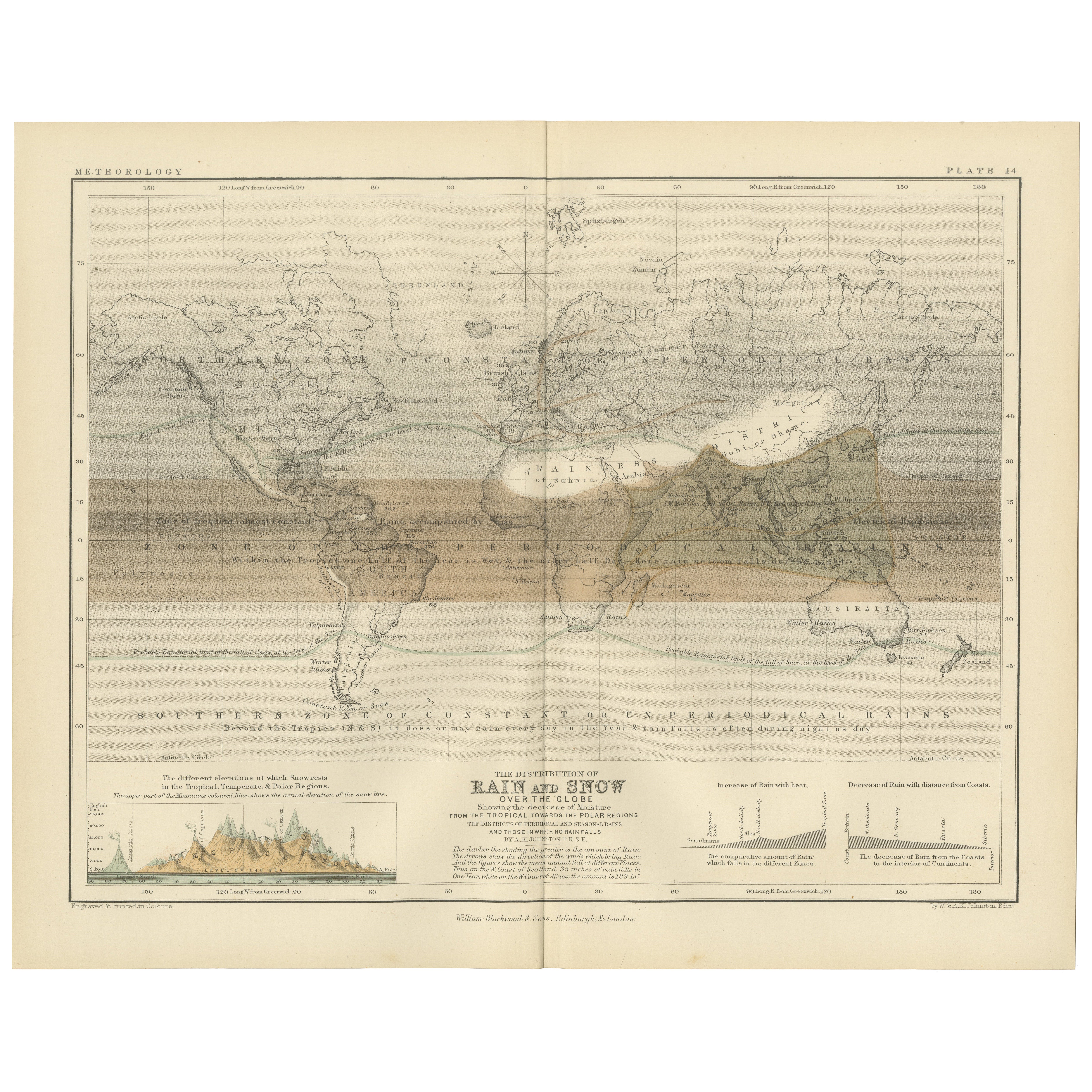
Rain and Snow Map by A.K. Johnston – Global Precipitation Chart 1852
Located in Langweer, NL
Rain and Snow Map by A.K. Johnston – Global Precipitation Chart 1852
This antique meteorological chart titled "The Distribution of Rain and Snow over the Globe" was created by Alexa...
Category
Antique Mid-19th Century Scottish Prints
Materials
Paper
Antique Map showing Isotherm Lines throughout the World by Johnston '1850'
Located in Langweer, NL
Antique map titled 'Humboldt's System of Isothermal Lines'. Original antique map showing isotherm lines throughout the world. This map originates from 'The Physical Atlas of Natural ...
Category
Antique Mid-19th Century Maps
Materials
Paper

$192 Sale Price
20% Off
Antique Map of the World Showing the Distribution of Plants and Minerals, 1872
Located in Langweer, NL
Antique map titled 'Johnson's World showing the distribution of the Characteristic Forest Trees (..)'. Original world map showing the distribution o...
Category
Antique Late 19th Century Maps
Materials
Paper

$192 Sale Price
20% Off
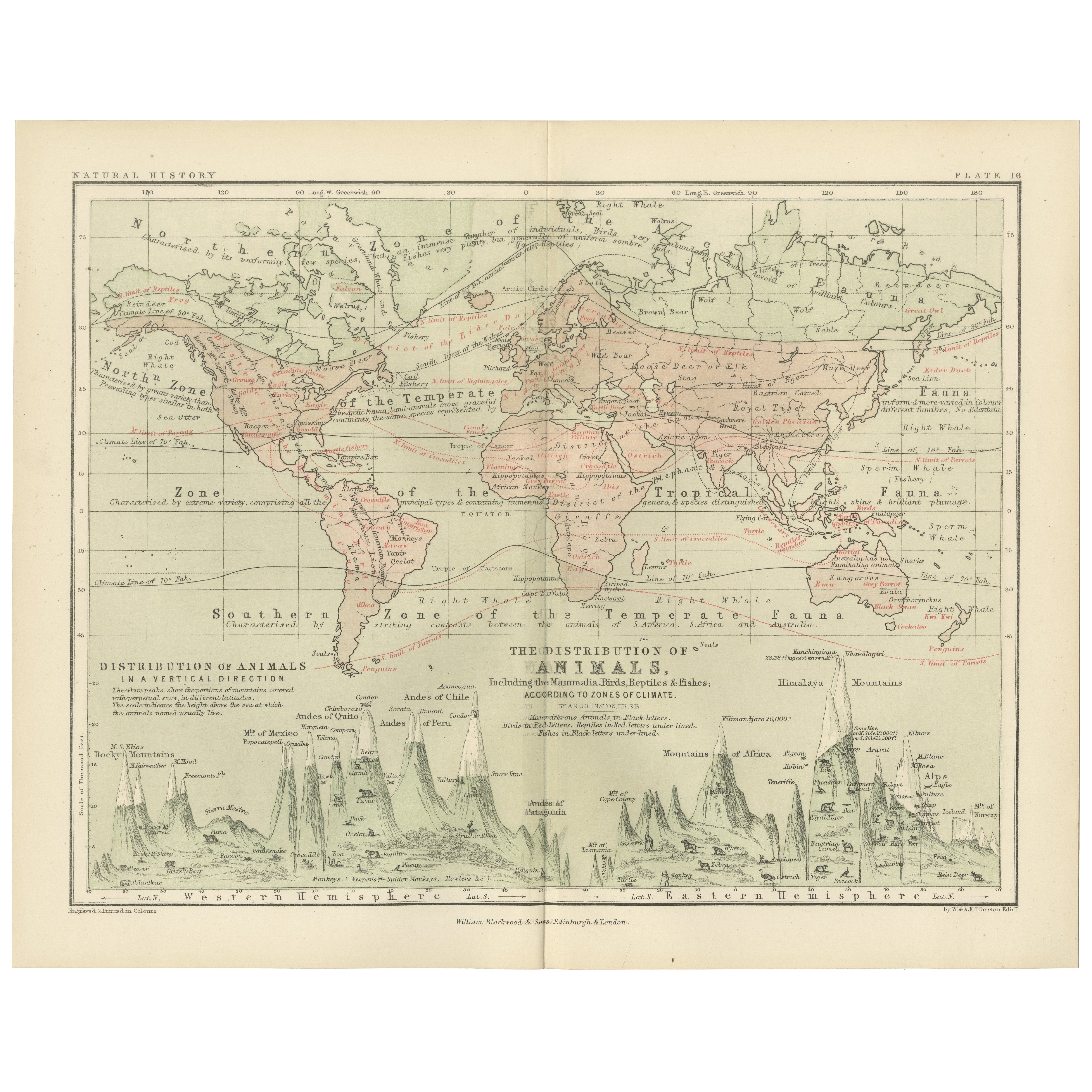
Animal Distribution Map by A.K. Johnston – Fauna by Climate Zones 1852
Located in Langweer, NL
Animal Distribution Map by A.K. Johnston – Fauna by Climate Zones 1852
This beautifully engraved chart titled "The Distribution of Animals Including the Mammalia, Birds, Reptiles & ...
Category
Antique Mid-19th Century Scottish Prints
Materials
Paper
Antique Map Showing the Ocean Currents and Temperature of Air, '1872'
Located in Langweer, NL
Two maps on one sheet titled 'Johnson's Oceans Currents (..)' and 'Johnson's World showing the Distribution of the Temperature of the Air'. Original world map...
Category
Antique Late 19th Century Maps
Materials
Paper

$336 Sale Price
20% Off
You May Also Like
Original Antique Map of The World by Thomas Clerk, 1817
Located in St Annes, Lancashire
Great map of The Eastern and Western Hemispheres
On 2 sheets
Copper-plate engraving
Drawn and engraved by Thomas Clerk, Edinburgh.
Published by Mackenzie And Dent, 1817
...
Category
Antique 1810s English Maps
Materials
Paper

Original Antique Map of The Eastern Hemisphere by Dower, circa 1835
Located in St Annes, Lancashire
Nice map of the Eastern Hemisphere
Drawn and engraved by J.Dower
Published by Orr & Smith. C.1835
Unframed.
Free shipping
Category
Antique 1830s English Maps
Materials
Paper

Hemisphere Of The New Continent - Ancient Map by J.G. Heck - 1834.
By Johann Georg Heck
Located in Roma, IT
Hemisphere Of The New Continent is an artwork realized around 1760 by Johann Georg Heck
Original colored print.
Good conditions except for yellowing of paper and tears along the m...
Category
1830s Modern Figurative Prints
Materials
Etching

Original Antique Map of The World by Dower, circa 1835
Located in St Annes, Lancashire
Nice map of the World
Drawn and engraved by J.Dower
Published by Orr & Smith. C.1835
Unframed.
Free shipping
Category
Antique 1830s English Maps
Materials
Paper

Original Antique Map of The Western Hemisphere by Dower, circa 1835
Located in St Annes, Lancashire
Nice map of the Western Hemisphere
Drawn and engraved by J.Dower
Published by Orr & Smith. C.1835
Unframed.
Free shipping
Category
Antique 1830s English Maps
Materials
Paper

Old British Empire Map - Ancient Map by Karl Spruner - 1760 ca.
By Karl Spruner von Merz
Located in Roma, IT
Old British Empire Map is an artwork realized around 1760 by Karl Spruner.
Original hand-colored print.
Good conditions except for yellowing of pa...
Category
1760s Modern Figurative Prints
Materials
Etching

More Ways To Browse
Bronze Black Panthers
Bronze Chinoiserie Clock
Bronze Marly Horses
Bronze Singing Bowl
Bronze Sparrow
Brutalist Horse
Brutalist Zodiac
Buddha Head On Black Stand
Buffalo Horn Furniture
Bugatti Sculpture
Buncheong Ceramics
Cabinets Anglo Indian Rosewood
Carrera Dining Table
Carved Bone Elephants
Carved Censer
Carved Indian Chest
Carved Jade Figure
Carved Shell Cabinet