Items Similar to Ethnographic Map of the World by A.K. Johnston – Races of Man Chart 1852


Want more images or videos?
Request additional images or videos from the seller
1 of 10
Ethnographic Map of the World by A.K. Johnston – Races of Man Chart 1852
$311.68per item
£231.53per item
€260per item
CA$432.80per item
A$472.28per item
CHF 247.72per item
MX$5,736.02per item
NOK 3,094.15per item
SEK 2,924.13per item
DKK 1,979.35per item
Quantity
About the Item
Ethnographic Map of the World by A.K. Johnston – Races of Man Chart 1852
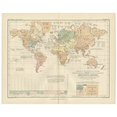
This antique map titled "Ethnographic Map of the World Showing the Present Distribution of the Leading Races of Man" was created by Alexander Keith Johnston and published in 1852 by William Blackwood & Sons in Edinburgh and London. Issued as Plate 17 in Johnston’s *Physical Atlas of Natural Phenomena*, this map reflects 19th-century efforts to visualize human diversity across the globe through early ethnographic theory.
The map categorizes the world's populations into ten generalized racial and cultural groupings, each represented in distinct pastel shades. These include classifications such as Indo-European, Semitic, Negro, Mongolian, Malay, American, and others based on contemporary (now outdated) 19th-century anthropological thought. The regions of distribution are shaded accordingly, spanning continents from the Arctic Circle to the islands of the Pacific.
A large inset map at the bottom right provides a focused view of Europe, showing greater detail in the distribution of groups such as Slavonic, Germanic, Celtic, Basque, and Finnic peoples. Alongside it is a striking profile diagram illustrating the elevation of Earth's landmasses, tying physical geography to patterns of human settlement.
This map, like many from the mid-19th century, combines the empirical ambitions of early anthropology with the visual clarity of scientific cartography. While its categories and terminology are now considered outdated and oversimplified, the chart is an important artifact from the history of ethnography and reflects the European scientific worldview of the time.
Alexander Keith Johnston (1804–1871), one of the most respected geographers of his age, created the *Physical Atlas* as an educational tool to help readers understand the natural world and its human patterns through maps. His work remains a landmark in the development of thematic cartography.
This plate is a compelling object for collectors of antique maps, anthropology history, or Victorian educational materials, and is often studied for its role in the evolution of ethnographic science.
Condition and framing tips:
Very good condition with minimal age toning and a clean printed surface. Centerfold as issued. Frame in black or dark oak wood with a neutral ivory or parchment mat to complement the subdued palette and historic typography. Suitable for a library, academic office, or collection of early scientific prints.
- Dimensions:Height: 10.79 in (27.4 cm)Width: 13.59 in (34.5 cm)Depth: 0.01 in (0.2 mm)
- Materials and Techniques:
- Place of Origin:
- Period:
- Date of Manufacture:1852
- Condition:Very good condition. Light overall toning near the margins and some offset over Europe. The paper remains strong and well-preserved. Folding line as issued.
- Seller Location:Langweer, NL
- Reference Number:Seller: BG-13207-171stDibs: LU3054345393552
About the Seller
5.0
Recognized Seller
These prestigious sellers are industry leaders and represent the highest echelon for item quality and design.
Platinum Seller
Premium sellers with a 4.7+ rating and 24-hour response times
Established in 2009
1stDibs seller since 2017
2,641 sales on 1stDibs
Typical response time: <1 hour
- ShippingRetrieving quote...Shipping from: Langweer, Netherlands
- Return Policy
Authenticity Guarantee
In the unlikely event there’s an issue with an item’s authenticity, contact us within 1 year for a full refund. DetailsMoney-Back Guarantee
If your item is not as described, is damaged in transit, or does not arrive, contact us within 7 days for a full refund. Details24-Hour Cancellation
You have a 24-hour grace period in which to reconsider your purchase, with no questions asked.Vetted Professional Sellers
Our world-class sellers must adhere to strict standards for service and quality, maintaining the integrity of our listings.Price-Match Guarantee
If you find that a seller listed the same item for a lower price elsewhere, we’ll match it.Trusted Global Delivery
Our best-in-class carrier network provides specialized shipping options worldwide, including custom delivery.More From This Seller
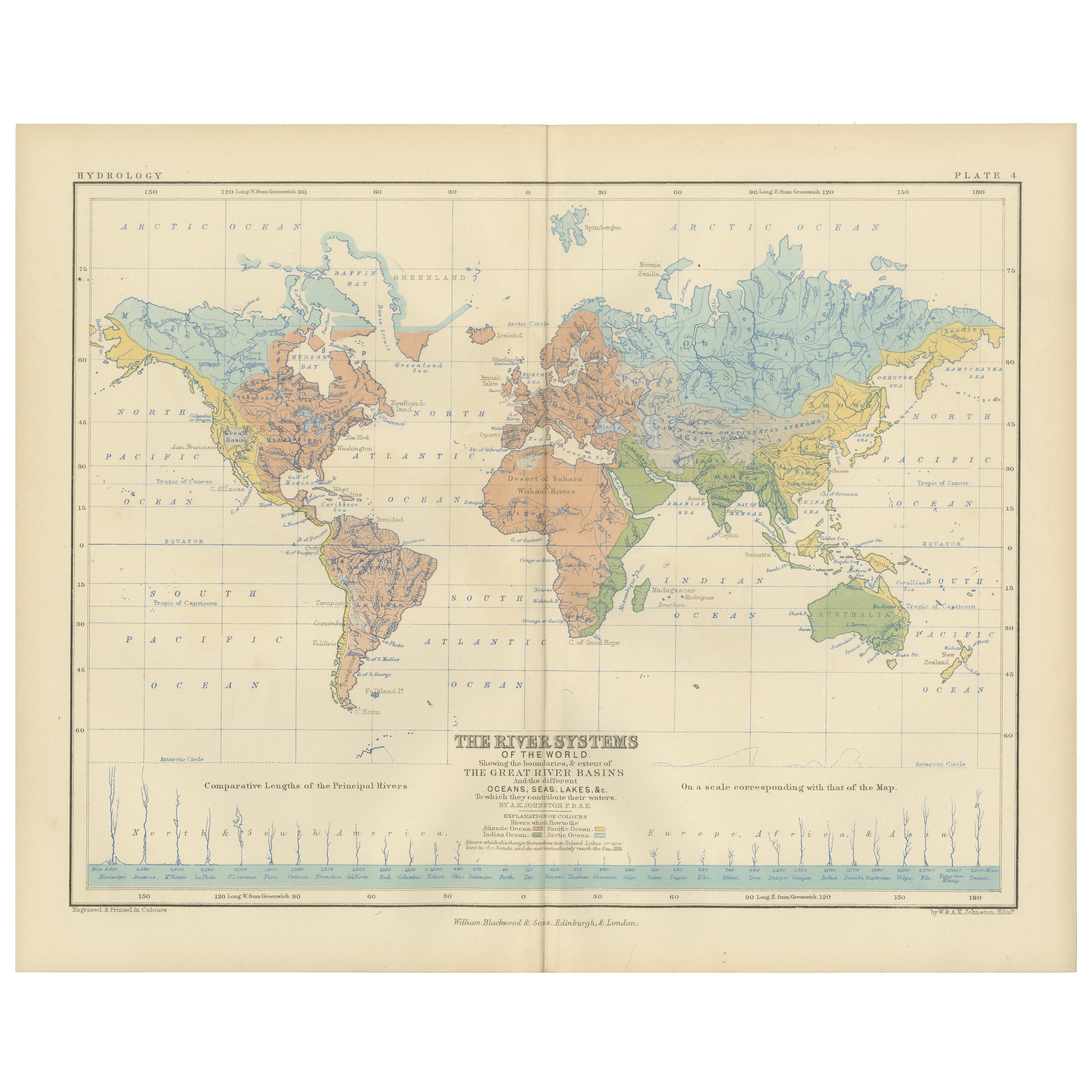
View AllRiver Systems Map of the World by A.K. Johnston – Educational Print 1852
Located in Langweer, NL
River Systems Map of the World by A.K. Johnston – Educational Print 1852
This striking 1852 map titled "The River Systems of the World" was created by the noted Scottish geographer ...
Category
Antique Mid-19th Century Scottish Prints
Materials
Paper

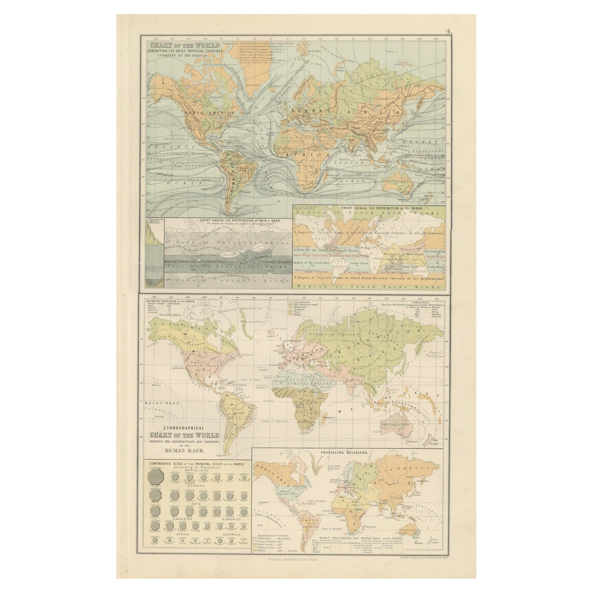
Antique Charts of the World – Physical Features and Ethnographical Map, 1884
Located in Langweer, NL
Antique Charts of the World – Physical Features and Ethnographical Map, 1884
Description:
This fascinating double plate from the New and Revised Edition of Black’s General Atlas of ...
Category
Antique 1880s Scottish Maps
Materials
Paper
Antique Map Showing the Religions Around the World by Johnston '1854'
Located in Langweer, NL
Antique map titled 'Moral & Statistical Chart showing the Geographical Distribution of Man According to Religious Belief'. Rare large-size thematic map on the distribution of religio...
Category
Antique Mid-19th Century Maps
Materials
Paper

$935 Sale Price
35% Off
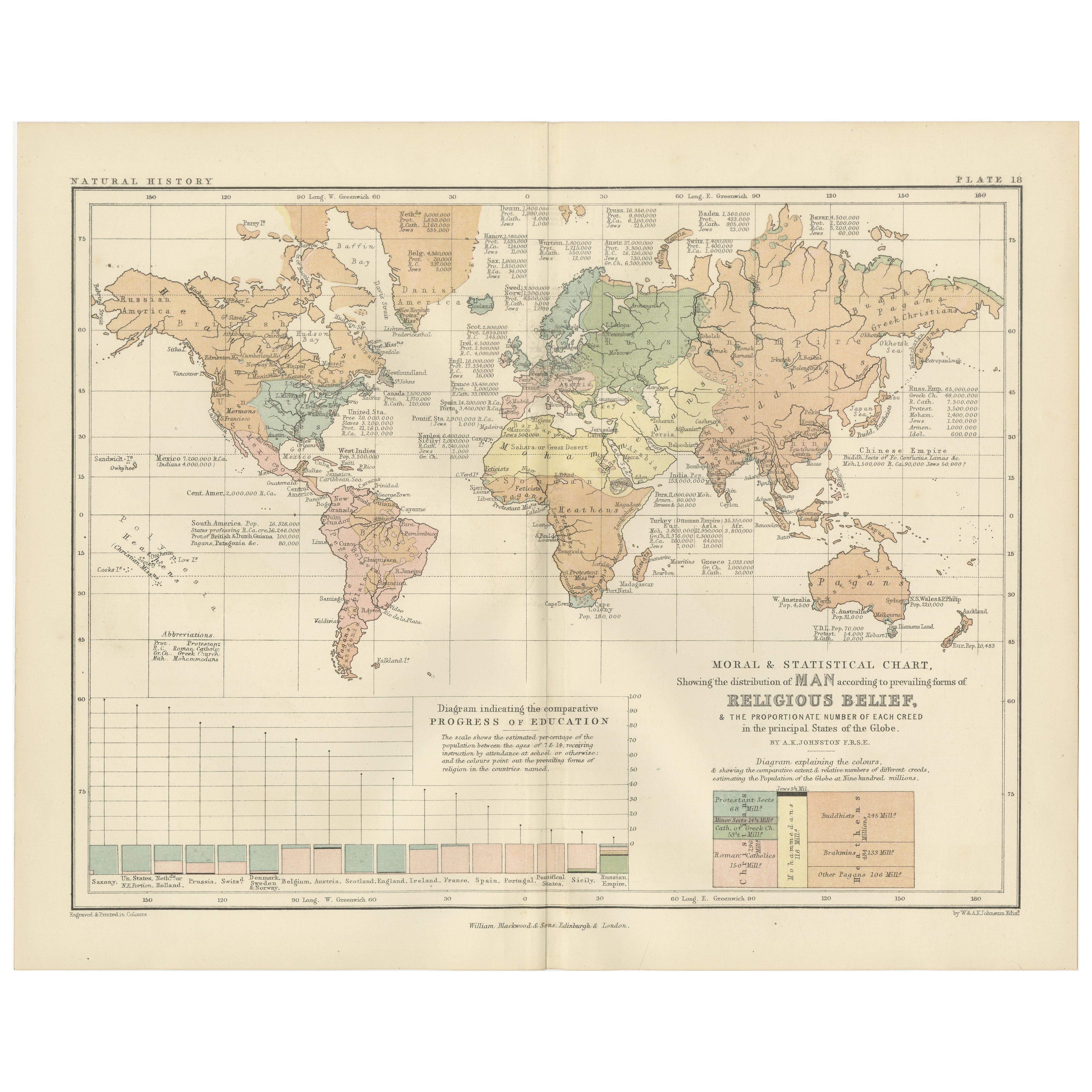
Religious Belief Map by A.K. Johnston – Moral and Statistical Chart 1852
Located in Langweer, NL
Religious Belief Map by A.K. Johnston – Moral and Statistical Chart 1852
This antique chart titled "Moral & Statistical Chart Showing the Distribution of Man According to Prevailing...
Category
Antique Mid-19th Century Scottish Prints
Materials
Paper
Antique Map of the World Showing the Distribution of Plants and Minerals, 1872
Located in Langweer, NL
Antique map titled 'Johnson's World showing the distribution of the Characteristic Forest Trees (..)'. Original world map showing the distribution o...
Category
Antique Late 19th Century Maps
Materials
Paper

$191 Sale Price
20% Off
Antique Map Showing the Division and Distribution of Mammals by Johnston '1850'
Located in Langweer, NL
Antique map titled 'Geographical division and distribution of mammiferous animals of the orders rodentia and ruminantia over the globe'. Original antique map showing geographical div...
Category
Antique Mid-19th Century Maps
Materials
Paper

$191 Sale Price
20% Off
You May Also Like
Original Antique Map of The World by Dower, circa 1835
Located in St Annes, Lancashire
Nice map of the World
Drawn and engraved by J.Dower
Published by Orr & Smith. C.1835
Unframed.
Free shipping
Category
Antique 1830s English Maps
Materials
Paper

1864 Original illustrated planisphere - World Map - Geography
Located in PARIS, FR
Immerse yourself in the epic journey of the past with the Illustrated Historical Planisphere of 1864 by Charpentier! 🗺️ This cartographic treasure transports you through the intrica...
Category
1860s Prints and Multiples
Materials
Linen, Lithograph, Paper

Old British Empire Map - Ancient Map by Karl Spruner - 1760 ca.
By Karl Spruner von Merz
Located in Roma, IT
Old British Empire Map is an artwork realized around 1760 by Karl Spruner.
Original hand-colored print.
Good conditions except for yellowing of pa...
Category
1760s Modern Figurative Prints
Materials
Etching

Map of the World - Original Etching - 1820
Located in Roma, IT
Map of the World is an Original Etching realized by an unknown artist of 19th century in 1820.
Very good condition on two sheets of white paper joine...
Category
1820s Modern Figurative Prints
Materials
Etching

Antique Map of Eastern Hemisphere from the collection of Thierry Despont
Located in New York, NY
Designed by Enrico Bonetti (E. Bonatti) and published by Francesco Vallardi Editore. Based on an earlier map by Evangelista Azzi (Ev. Azzi). Labeled as such at bottom edge of map.
T...
Category
Antique Late 19th Century Italian Maps
Materials
Canvas, Wood

Original Antique Map of The World by Thomas Clerk, 1817
Located in St Annes, Lancashire
Great map of The Eastern and Western Hemispheres
On 2 sheets
Copper-plate engraving
Drawn and engraved by Thomas Clerk, Edinburgh.
Published by Mackenzie And Dent, 1817
...
Category
Antique 1810s English Maps
Materials
Paper

More Ways To Browse
Indo European
Brutalist Horse
Brutalist Zodiac
Buddha Head On Black Stand
Buffalo Horn Furniture
Bugatti Sculpture
Buncheong Ceramics
Cabinets Anglo Indian Rosewood
Carrera Dining Table
Carved Bone Elephants
Carved Censer
Carved Indian Chest
Carved Jade Figure
Carved Shell Cabinet
Cased Fish
Cast Iron Horse Sculpture
Cat Sculpture Blue
Ceramic Blue Glazed Bird