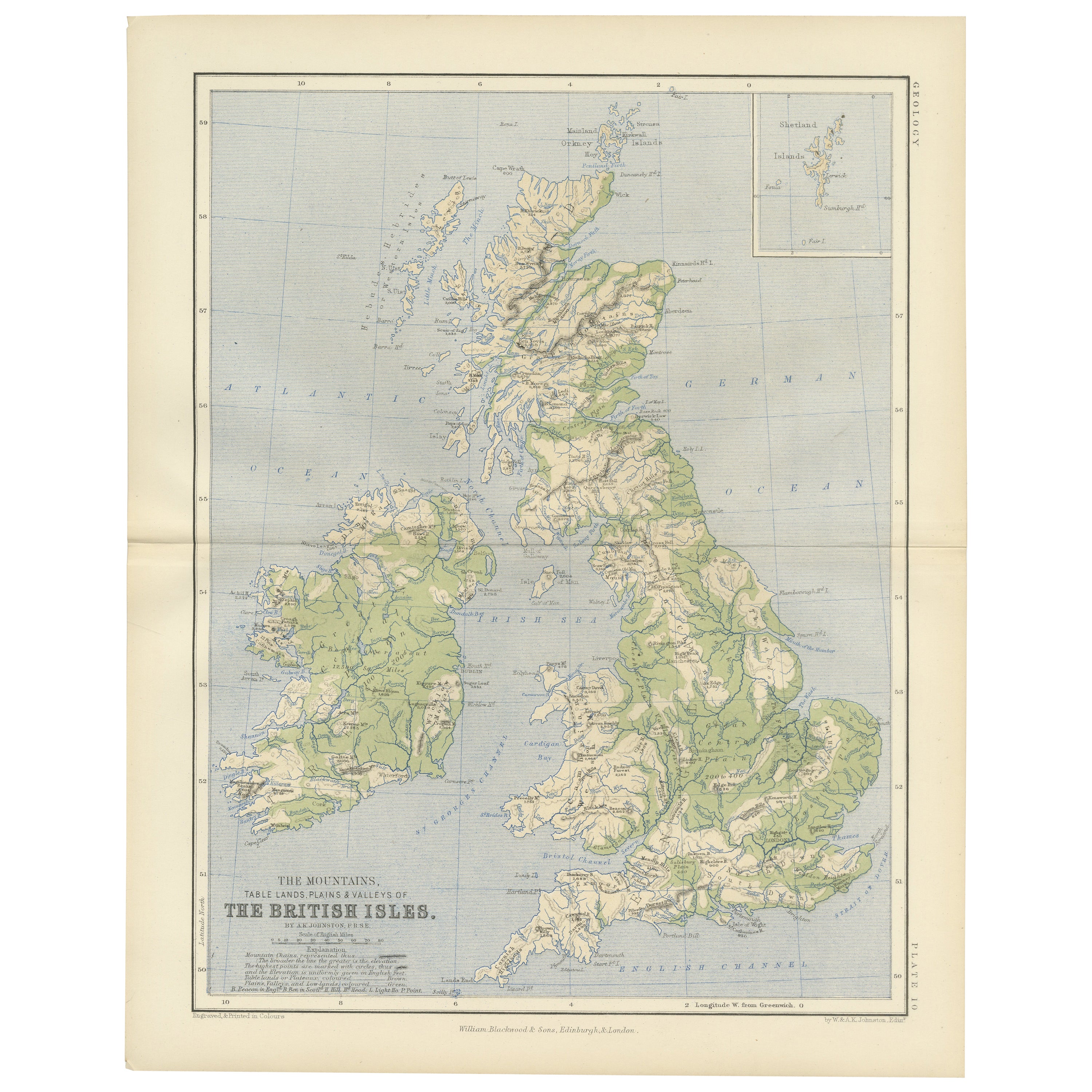
Items Similar to Geological Map of Europe by A.K. Johnston – Mountains and Valleys 1852


Want more images or videos?
Request additional images or videos from the seller
1 of 10
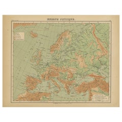
Geological Map of Europe by A.K. Johnston – Mountains and Valleys 1852
$310.40per item
£231.61per item
€260per item
CA$432.84per item
A$474.19per item
CHF 247.71per item
MX$5,700.70per item
NOK 3,096.76per item
SEK 2,920.74per item
DKK 1,979.85per item
Quantity
About the Item
Geological Map of Europe by A.K. Johnston – Mountains and Valleys 1852
This elegant 1852 map titled "The Mountains, Table Lands, Plains & Valleys of Europe" was designed by the acclaimed Scottish geographer Alexander Keith Johnston and published by William Blackwood & Sons, Edinburgh and London. Issued as Plate 5 in Johnston’s pioneering work *The Physical Atlas of Natural Phenomena*, this map presents a physical topographic view of Europe with a focus on land elevation and terrain structure, rather than political borders.
Rendered in soft shades of beige, green, and blue, the map clearly delineates Europe’s major mountain ranges, including the Alps, Pyrenees, Carpathians, Apennines, and the Scandinavian Mountains. Valleys, upland plateaus, and lowlands are carefully shaded and labeled, giving a three-dimensional sense of the landscape. The careful use of hachuring and color gradients creates a tactile impression of Europe’s relief, from the Scottish Highlands to the Ural Mountains.
Rather than showing countries, the map categorizes the land by geological and geomorphological features. The title and key in the lower right explain the distinctions between highlands, tablelands, and low plains, emphasizing natural geography over human boundaries. This approach reflects the 19th-century scientific movement toward thematic cartography—maps made not to navigate or govern, but to understand physical phenomena.
Alexander Keith Johnston (1804–1871), Geographer in Ordinary to the Queen for Scotland, was one of the most respected mapmakers of the Victorian era. His *Physical Atlas* was a groundbreaking work in visual science, and among the first to systematically map climate, geology, hydrology, and landforms across the globe.
This plate is a beautifully executed example of early data visualization and remains highly relevant for collectors of antique scientific prints, students of European geography, or those seeking refined decorative maps for libraries, studies, or offices.
Condition and framing tips:
Very good antique condition with minor toning and slight edge wear. The print retains sharp detail and gentle original coloring. Best displayed in a black or walnut frame with a warm ivory or soft grey mat to highlight the topographic textures and historic typographic style. Ideal for natural history interiors or scholarly settings.
- Dimensions:Height: 10.79 in (27.4 cm)Width: 13.59 in (34.5 cm)Depth: 0.01 in (0.2 mm)
- Materials and Techniques:
- Place of Origin:
- Period:
- Date of Manufacture:1852
- Condition:Very good condition. Light overall toning near the margins. The paper remains strong and well-preserved. Folding line as issued.
- Seller Location:Langweer, NL
- Reference Number:Seller: BG-13207-51stDibs: LU3054345386522
About the Seller
5.0
Recognized Seller
These prestigious sellers are industry leaders and represent the highest echelon for item quality and design.
Platinum Seller
Premium sellers with a 4.7+ rating and 24-hour response times
Established in 2009
1stDibs seller since 2017
2,653 sales on 1stDibs
Typical response time: <1 hour
- ShippingRetrieving quote...Shipping from: Langweer, Netherlands
- Return Policy
Authenticity Guarantee
In the unlikely event there’s an issue with an item’s authenticity, contact us within 1 year for a full refund. DetailsMoney-Back Guarantee
If your item is not as described, is damaged in transit, or does not arrive, contact us within 7 days for a full refund. Details24-Hour Cancellation
You have a 24-hour grace period in which to reconsider your purchase, with no questions asked.Vetted Professional Sellers
Our world-class sellers must adhere to strict standards for service and quality, maintaining the integrity of our listings.Price-Match Guarantee
If you find that a seller listed the same item for a lower price elsewhere, we’ll match it.Trusted Global Delivery
Our best-in-class carrier network provides specialized shipping options worldwide, including custom delivery.More From This Seller
View AllRelief Atlas Map of Europe by Hachette – Antique French Map c.1883
Located in Langweer, NL
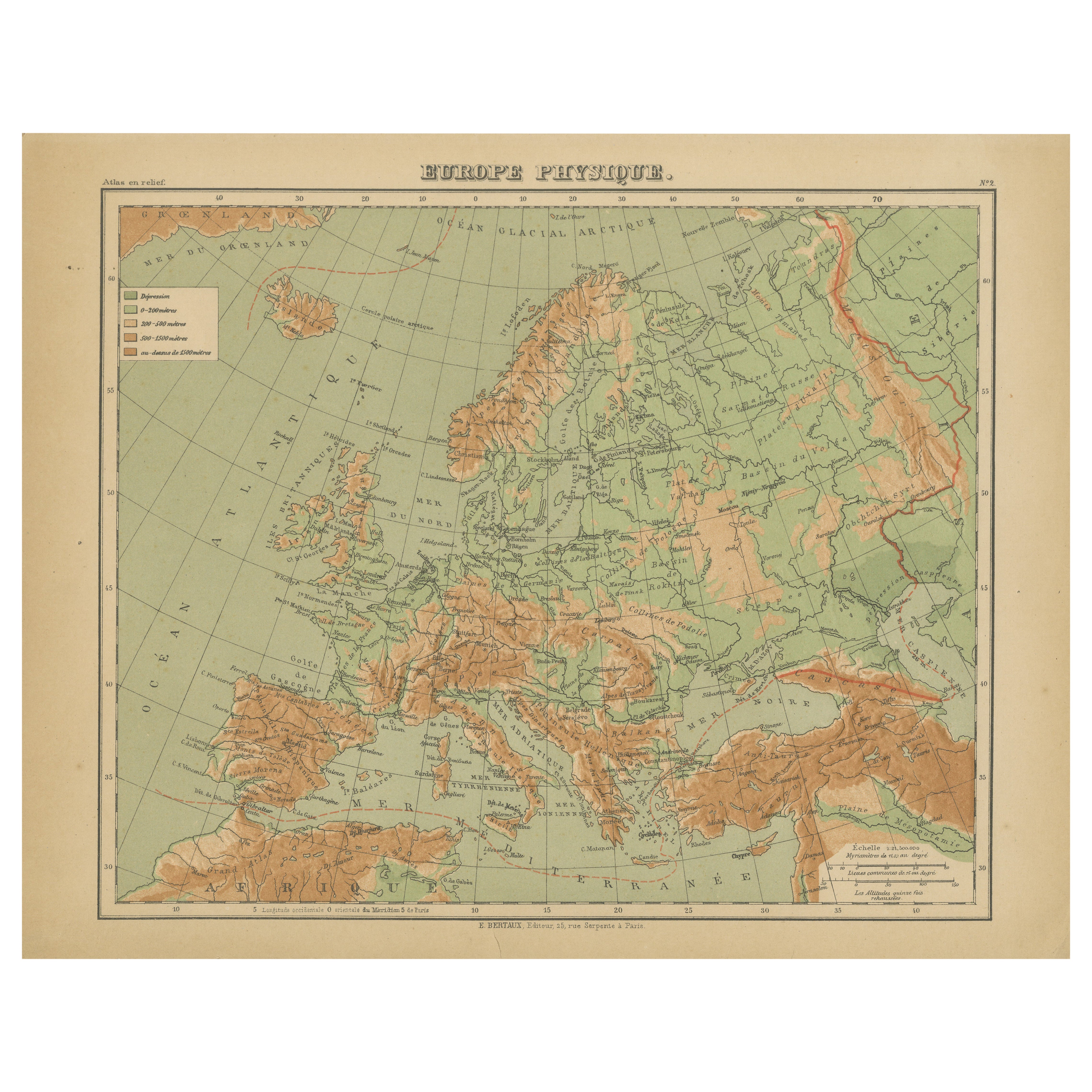
Antique Map of Europe – Physical Relief Map by Hachette, circa 1883
Description:
This antique map titled “Europe Physique” was published by Hachette in Paris around 1883 and origina...
Category
Antique Late 19th Century French Maps
Materials
Paper
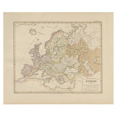
Europe Map – Rivers, Watersheds and Elevation, Published in 1857
Located in Langweer, NL
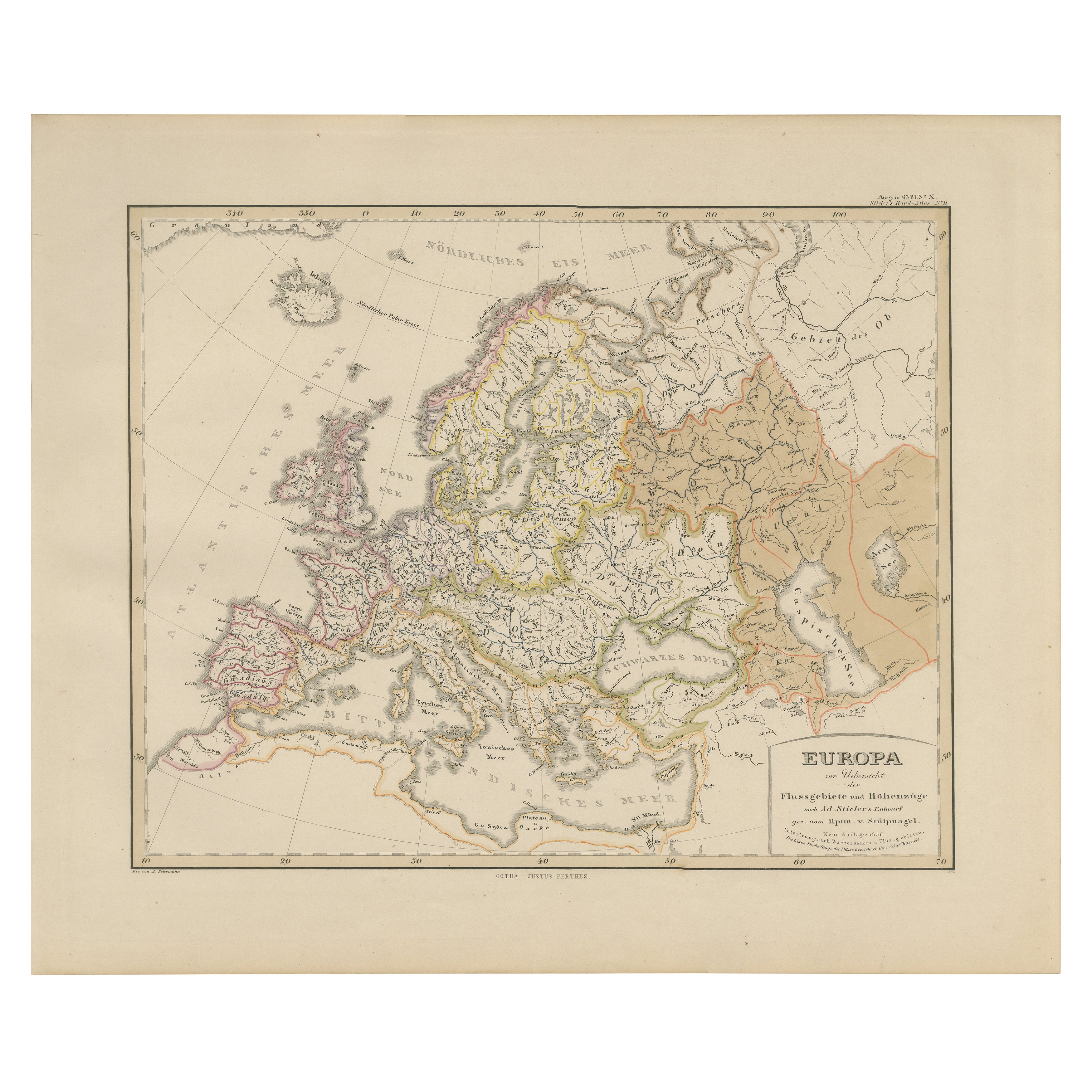
Europe Map – Rivers, Watersheds and Elevation 1857
This beautiful antique print shows Europe with its river systems and watershed regions, titled “Europa zur Übersicht der Flussgebi...
Category
Antique Mid-19th Century German Maps
Materials
Paper
Antique Map of Europe, 1903, with Intricate Political Boundaries and Rich Detail
Located in Langweer, NL
Title: Antique Map of Europe, 1903, with Intricate Political Boundaries and Rich Detail
Description:
This antique map, titled "Europe," is a finely engraved and beautifully colored ...
Category
Early 20th Century Maps
Materials
Paper

Antique Map of Europe by W. G. Blackie, 1859
Located in Langweer, NL
Antique map titled 'Europe'. Original antique map of Europe. This map originates from ‘The Imperial Atlas of Modern Geography’. Published by W. G. Blackie, 1859.
Category
Antique Mid-19th Century Maps
Materials
Paper

$238 Sale Price
20% Off
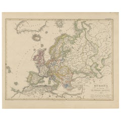
Europe Map – Political Divisions and Borders, Published in 1858
Located in Langweer, NL
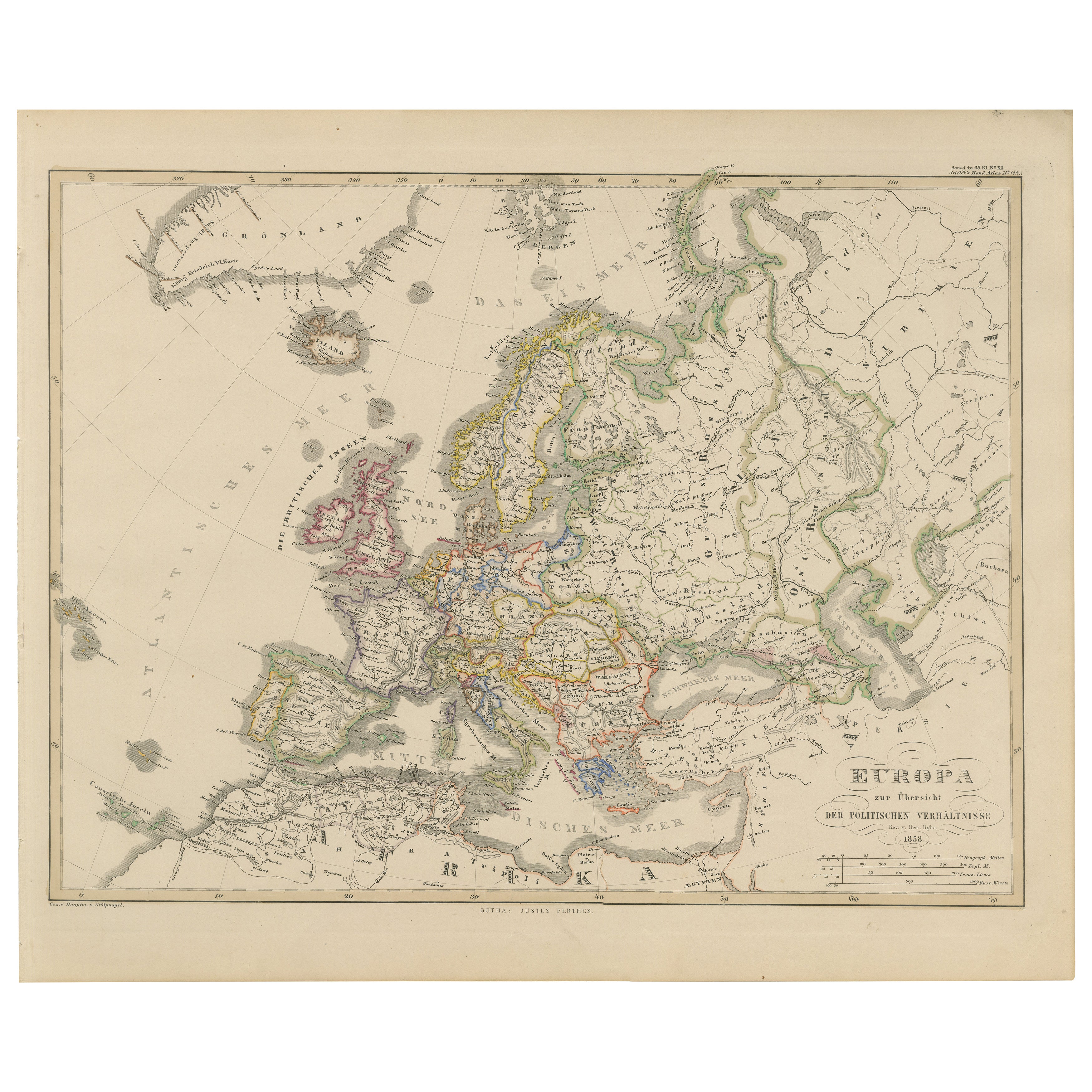
Europe Map – Political Divisions and Borders 1858
This fine antique print shows Europe with its political divisions titled “Europa zur Übersicht der politischen Verhältnisse” meanin...
Category
Antique Mid-19th Century German Maps
Materials
Paper
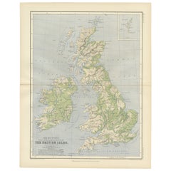
Geological Map of the British Isles by A.K. Johnston – Highlands & Valleys 1852
Located in Langweer, NL
Geological Map of the British Isles by A.K. Johnston – Highlands & Valleys 1852
This antique topographic map titled "The Mountains, Table Lan...
Category
Antique Mid-19th Century Scottish Prints
Materials
Paper
You May Also Like
Map of Europe, 1844
Located in Houston, TX
Over 150 year old engraved map of Europe by Olney from 1844. Original hand color. Shows Northern Europe, Prussia and Germany.
Original antique map o...
Category
1840s More Prints
Materials
Ink, Watercolor, Handmade Paper

Large Original Antique Map of Europe by Sidney Hall, 1847
Located in St Annes, Lancashire
Great map of Europe
Drawn and engraved by Sidney Hall
Steel engraving
Original colour outline
Published by A & C Black. 1847
Unframed
Free shipping.
Category
Antique 1840s Scottish Maps
Materials
Paper

Original Antique Map of Europe, Arrowsmith, 1820
Located in St Annes, Lancashire
Great map of Europe
Drawn under the direction of Arrowsmith.
Copper-plate engraving.
Published by Longman, Hurst, Rees, Orme and Brown, 1820
...
Category
Antique 1820s English Maps
Materials
Paper

Two-Part Large Hand-Colored Map of Europe from 1798
By Thomas Kitchin
Located in New York, NY
Map of Europe printed on two separate sheets from A New Universal Atlas by Thomas Kitchin. Published in London by Laurie & Whittle, 1798. Original engravings hand-colored at publicat...
Category
1790s More Art
Materials
Paper

$1,700 Sale Price
33% Off
1790 Thomas Stackhouse Map, Entitled "Russia in Europe, " , Ric.a004
Located in Norton, MA
1790 Thomas Stackhouse map, entitled
"Russia in Europe"
Ric.a004
Stackhouse, Thomas
Russia in Europe [map]
London: T. Stackhouse, 1783. Map. Matted hand-colored copper engraving. Image size: 14.5 x 15.25 inches. Mat size: 22.75 x 23.75 inches. A beautiful example of this map of Eastern Europe...
Category
Antique 17th Century Unknown Maps
Materials
Paper

France, Northern Part. Century Atlas antique map
Located in Melbourne, Victoria
'The Century Atlas. France, Northern Part.'
Original antique map, 1903.
Inset maps of 'France in Provinces' and 'Paris and Vicinity'.
Central fold as issued. Map name and number pr...
Category
Early 20th Century Victorian More Prints
Materials
Lithograph

More Ways To Browse
Bronze Black Panthers
Bronze Chinoiserie Clock
Bronze Marly Horses
Bronze Singing Bowl
Bronze Sparrow
Brutalist Horse
Brutalist Zodiac
Buddha Head On Black Stand
Buffalo Horn Furniture
Bugatti Sculpture
Buncheong Ceramics
Cabinets Anglo Indian Rosewood
Carrera Dining Table
Carved Bone Elephants
Carved Censer
Carved Indian Chest
Carved Jade Figure
Carved Shell Cabinet