Items Similar to Religious Belief Map by A.K. Johnston – Moral and Statistical Chart 1852


Want more images or videos?
Request additional images or videos from the seller
1 of 11
Religious Belief Map by A.K. Johnston – Moral and Statistical Chart 1852
$311.68per item
£231.53per item
€260per item
CA$432.80per item
A$472.28per item
CHF 247.72per item
MX$5,736.02per item
NOK 3,094.15per item
SEK 2,924.13per item
DKK 1,979.35per item
Quantity
About the Item
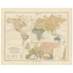
Religious Belief Map by A.K. Johnston – Moral and Statistical Chart 1852
This antique chart titled "Moral & Statistical Chart Showing the Distribution of Man According to Prevailing Forms of Religious Belief & the Proportionate Number of Each Creed in the Principal States of the Globe" was created by Alexander Keith Johnston and published in 1852 by William Blackwood & Sons in Edinburgh and London. Issued as Plate 18 in Johnston’s *Physical Atlas of Natural Phenomena*, this map is a rare and historically significant early attempt to visualize global religious demographics.
The world is color-coded to reflect the dominant religions in various regions, including Christianity (with Roman Catholic, Greek Orthodox, and Protestant branches distinguished), Islam (Sunni and Shiite), Buddhism, Brahmanism (Hinduism), Judaism, and areas broadly labeled as "Heathen" or "Other Faiths," in accordance with 19th-century terminology. The color-coded legend to the lower right includes estimated numbers of adherents for each group, offering a numerical context to the geographic distribution.
Each country or empire is labeled with estimates of its religious composition and population size, from the British Isles and Ottoman Empire to China, Russia, India, and the Americas. The chart reflects not only religious spread, but also the political-religious affiliations of empires and colonial powers during the mid-19th century.
At the bottom of the chart is a diagram titled “Progress of Education,” using bar graphs to compare levels of literacy and schooling across nations—an early example of combining moral and statistical inquiry through cartography. Countries such as Prussia, Scotland, and Saxony rank highest in this education index, while others show much lower rates of public instruction, as interpreted from available data at the time.
Alexander Keith Johnston (1804–1871), Geographer in Ordinary to Queen Victoria in Scotland, was a pioneer in thematic and scientific cartography. His *Physical Atlas* was one of the first atlases to integrate human, environmental, and physical data into visually compelling and educational maps.
This plate is of particular interest to collectors of religious history, antique data visualization, and 19th-century worldviews. It reflects the empirical spirit of the age, while also serving as a historical document of cultural perspectives from a European scientific lens.
Condition and framing tips:
Very good antique condition with some mild age toning and a clean printed surface. Original centerfold as issued. Frame in a dark or neutral wood with a cream or parchment mat to complement the subtle pastel palette and enhance legibility. Ideal for display in a study, library, or historical institution.
- Dimensions:Height: 10.79 in (27.4 cm)Width: 13.59 in (34.5 cm)Depth: 0.01 in (0.2 mm)
- Materials and Techniques:
- Place of Origin:
- Period:
- Date of Manufacture:1852
- Condition:Very good condition. Light overall toning near the margins. The paper remains strong and well-preserved. Folding line as issued.
- Seller Location:Langweer, NL
- Reference Number:Seller: BG-13207-181stDibs: LU3054345393582
About the Seller
5.0
Recognized Seller
These prestigious sellers are industry leaders and represent the highest echelon for item quality and design.
Platinum Seller
Premium sellers with a 4.7+ rating and 24-hour response times
Established in 2009
1stDibs seller since 2017
2,641 sales on 1stDibs
Typical response time: <1 hour
- ShippingRetrieving quote...Shipping from: Langweer, Netherlands
- Return Policy
Authenticity Guarantee
In the unlikely event there’s an issue with an item’s authenticity, contact us within 1 year for a full refund. DetailsMoney-Back Guarantee
If your item is not as described, is damaged in transit, or does not arrive, contact us within 7 days for a full refund. Details24-Hour Cancellation
You have a 24-hour grace period in which to reconsider your purchase, with no questions asked.Vetted Professional Sellers
Our world-class sellers must adhere to strict standards for service and quality, maintaining the integrity of our listings.Price-Match Guarantee
If you find that a seller listed the same item for a lower price elsewhere, we’ll match it.Trusted Global Delivery
Our best-in-class carrier network provides specialized shipping options worldwide, including custom delivery.More From This Seller
View AllAntique Map Showing the Religions Around the World by Johnston '1854'
Located in Langweer, NL
Antique map titled 'Moral & Statistical Chart showing the Geographical Distribution of Man According to Religious Belief'. Rare large-size thematic map on the distribution of religio...
Category
Antique Mid-19th Century Maps
Materials
Paper

$935 Sale Price
35% Off
Ethnographic Map of the World by A.K. Johnston – Races of Man Chart 1852
Located in Langweer, NL
Ethnographic Map of the World by A.K. Johnston – Races of Man Chart 1852
This antique map titled "Ethnographic Map of the World Showing the Present Distribution of the Leading Races...
Category
Antique Mid-19th Century Scottish Prints
Materials
Paper
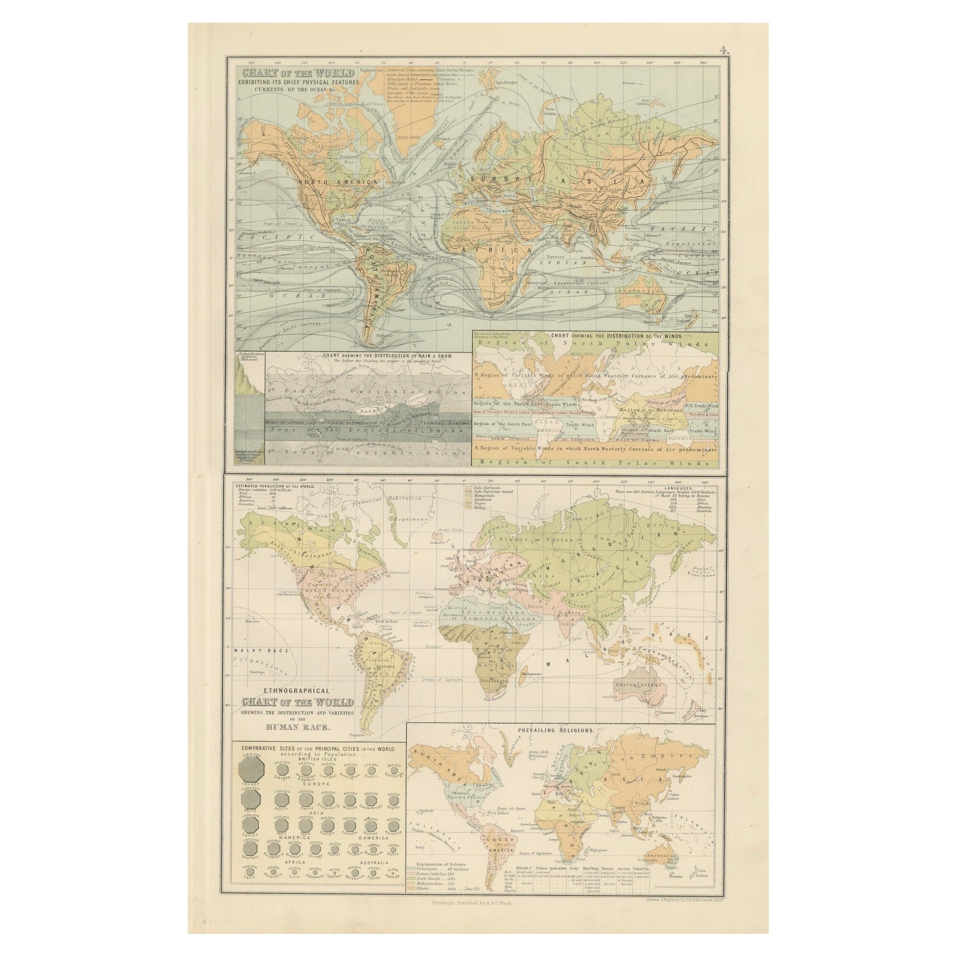
Antique Charts of the World – Physical Features and Ethnographical Map, 1884
Located in Langweer, NL
Antique Charts of the World – Physical Features and Ethnographical Map, 1884
Description:
This fascinating double plate from the New and Revised Edition of Black’s General Atlas of ...
Category
Antique 1880s Scottish Maps
Materials
Paper
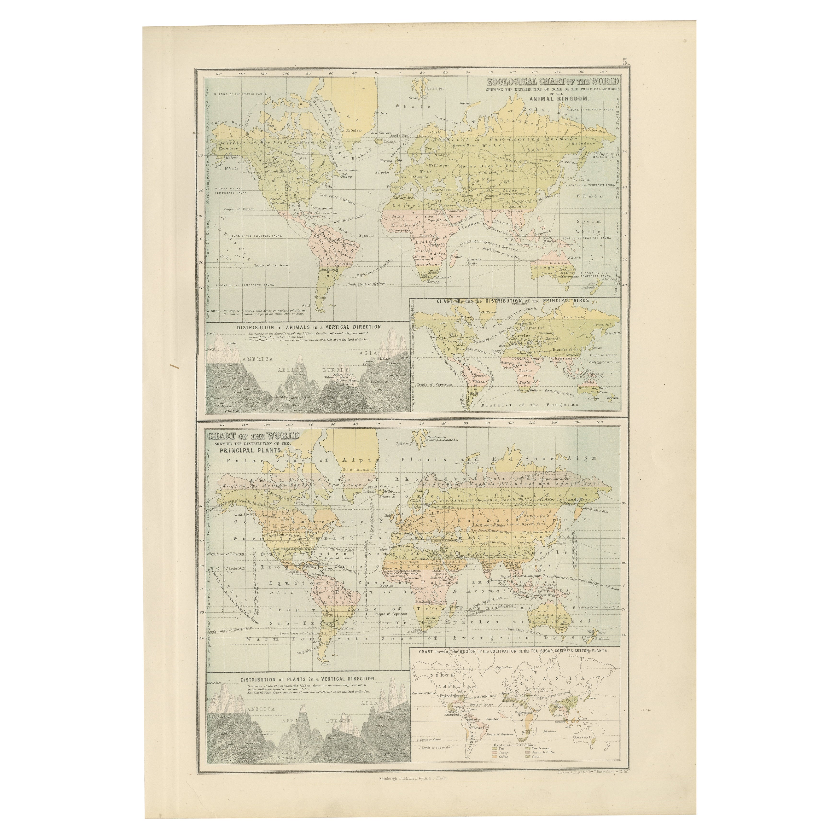
Antique Zoological and Botanical Chart of the World – Decorative Map, 1884
Located in Langweer, NL
Antique Zoological and Botanical Charts of the World – Black’s Atlas, 1884
This double plate from the New and Revised Edition of Black’s General Atlas of the World, published in Edi...
Category
Antique 1880s Scottish Maps
Materials
Paper
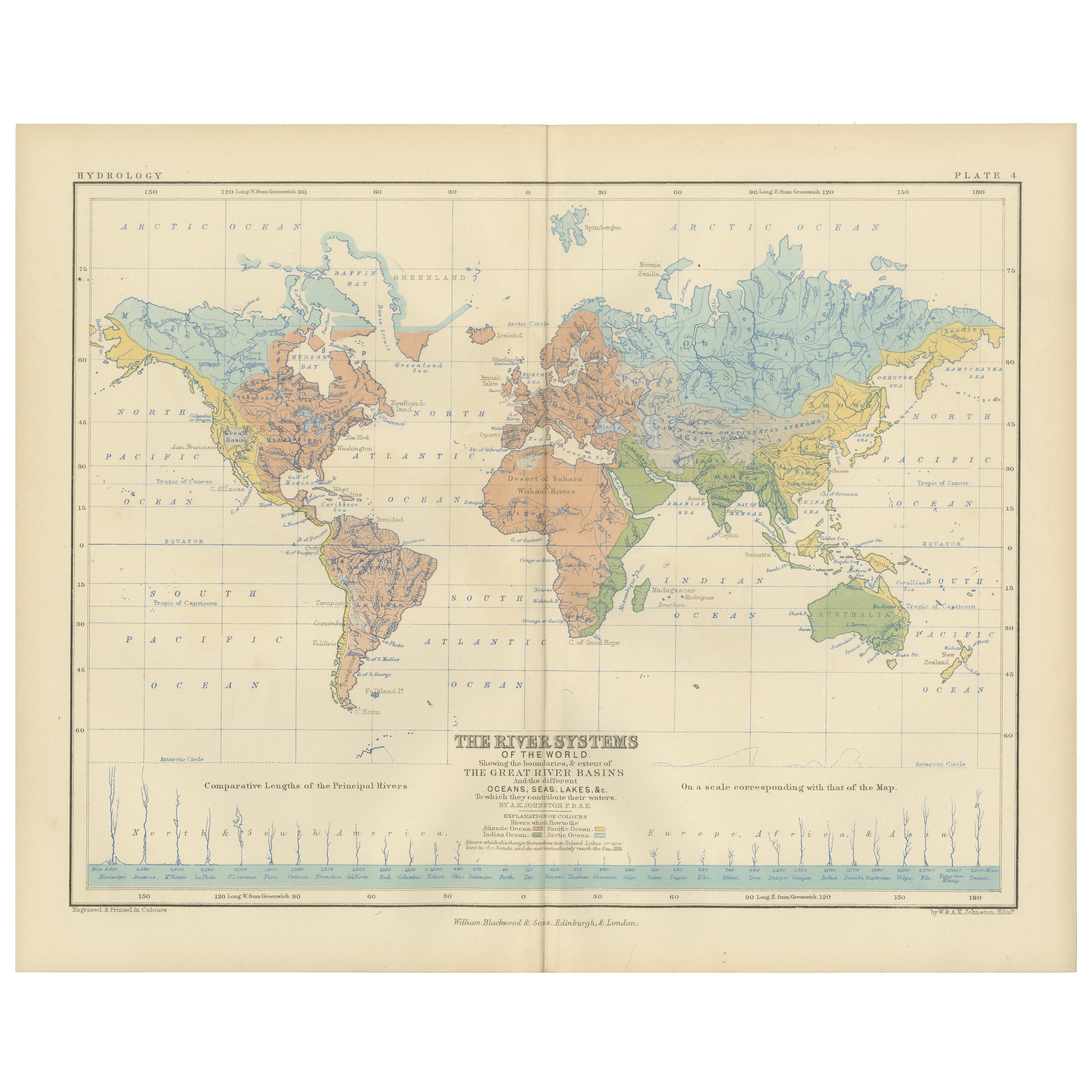
River Systems Map of the World by A.K. Johnston – Educational Print 1852
Located in Langweer, NL
River Systems Map of the World by A.K. Johnston – Educational Print 1852
This striking 1852 map titled "The River Systems of the World" was created by the noted Scottish geographer ...
Category
Antique Mid-19th Century Scottish Prints
Materials
Paper

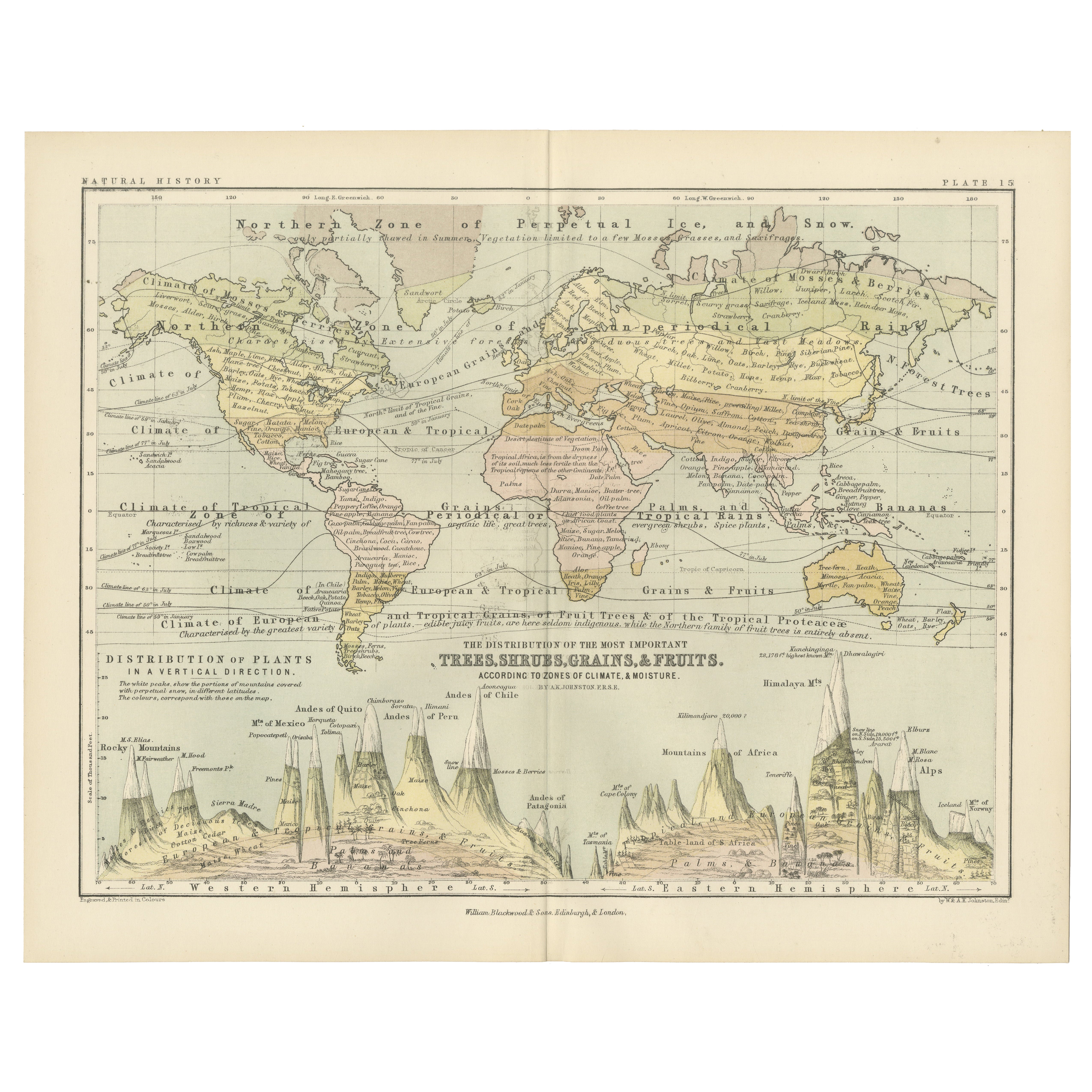
Botanical Map by A.K. Johnston – Global Plant Distribution Chart 1852
Located in Langweer, NL
Botanical Map by A.K. Johnston – Global Plant Distribution Chart 1852
This remarkable antique chart titled "The Distribution of the Most Important Trees, Shrubs, Grains, & Fruits Ac...
Category
Antique Mid-19th Century Scottish Prints
Materials
Paper
You May Also Like
Original Antique Map of The World by Dower, circa 1835
Located in St Annes, Lancashire
Nice map of the World
Drawn and engraved by J.Dower
Published by Orr & Smith. C.1835
Unframed.
Free shipping
Category
Antique 1830s English Maps
Materials
Paper

Old British Empire Map - Ancient Map by Karl Spruner - 1760 ca.
By Karl Spruner von Merz
Located in Roma, IT
Old British Empire Map is an artwork realized around 1760 by Karl Spruner.
Original hand-colored print.
Good conditions except for yellowing of pa...
Category
1760s Modern Figurative Prints
Materials
Etching

Large Original Antique Map of The World, Fullarton, C.1870
Located in St Annes, Lancashire
Great map of the World. Showing both hemispheres
From the celebrated Royal Illustrated Atlas
Lithograph. Original color.
Published by Fullarton, Edinburgh, C.1870
Unframed.
Rep...
Category
Antique 1870s Scottish Maps
Materials
Paper

1864 Original illustrated planisphere - World Map - Geography
Located in PARIS, FR
Immerse yourself in the epic journey of the past with the Illustrated Historical Planisphere of 1864 by Charpentier! 🗺️ This cartographic treasure transports you through the intrica...
Category
1860s Prints and Multiples
Materials
Linen, Lithograph, Paper

1864 Johnson's Map of the World on Mercator's Projection, Ric.B009
Located in Norton, MA
An 1864 Johnson's map of
the World on Mercator's Projection
Ric.b009
About this Item
"This antique map came from Johnson's New Illustrated (Steel Plate) Family Atlas, publ...
Category
Antique 19th Century Dutch Maps
Materials
Paper

Original Antique Map of The Eastern Hemisphere by Dower, circa 1835
Located in St Annes, Lancashire
Nice map of the Eastern Hemisphere
Drawn and engraved by J.Dower
Published by Orr & Smith. C.1835
Unframed.
Free shipping
Category
Antique 1830s English Maps
Materials
Paper

More Ways To Browse
Brutalist Horse
Brutalist Zodiac
Buddha Head On Black Stand
Buffalo Horn Furniture
Bugatti Sculpture
Buncheong Ceramics
Cabinets Anglo Indian Rosewood
Carrera Dining Table
Carved Bone Elephants
Carved Censer
Carved Indian Chest
Carved Jade Figure
Carved Shell Cabinet
Cased Fish
Cast Iron Horse Sculpture
Cat Sculpture Blue
Ceramic Blue Glazed Bird
Ceramic Canister