Schley, Xinjiang Uygur Zizhiqu, Tien Shan, Sinkiang, Map of China
View Similar Items


Want more images or videos?
Request additional images or videos from the seller
1 of 7
Schley, Xinjiang Uygur Zizhiqu, Tien Shan, Sinkiang, Map of China
About the Item
- Creator:Jacques-Nicolas Bellin (Artist)
- Dimensions:Height: 10.63 in (27 cm)Width: 14.18 in (36 cm)Depth: 0.04 in (1 mm)
- Materials and Techniques:Paper,Etched
- Place of Origin:
- Period:1740-1749
- Date of Manufacture:1749
- Condition:Wear consistent with age and use.
- Seller Location:Norwich, GB
- Reference Number:1stDibs: LU7031230847132

Jacques-Nicolas Bellin
Jacques Nicolas Bellin (1703 –1772) was a French hydrographer (official cartographer) and a geographer. While still a teenager he became the chief cartographer to the French Navy and later to the king of France. Bellin created a large number of maps for Antoine François Prévost's (L'Abbe Prevost) 'Histoire Generale des Voyages', which was a 25 volume publication focused on 17th and 18th century exploration.It was published in French, Dutch and German. He also contributed maps and articles to the 35-volume Encyclopédie edited by Denis Diderot and Jean le Rond d'Alembert. He was part of the group called Philosophes, which included many of the great intellectuals of the Age of Enlightenment, including Voltaire, Rousseau and Montesquieu. Bellin died at Versailles in 1772.
About the Seller
No Reviews Yet
Vetted Professional Seller
Every seller passes strict standards for authenticity and reliability
Established in 1992
1stDibs seller since 2022
10 sales on 1stDibs
Authenticity Guarantee
In the unlikely event there’s an issue with an item’s authenticity, contact us within 1 year for a full refund. DetailsMoney-Back Guarantee
If your item is not as described, is damaged in transit, or does not arrive, contact us within 7 days for a full refund. Details24-Hour Cancellation
You have a 24-hour grace period in which to reconsider your purchase, with no questions asked.Vetted Professional Sellers
Our world-class sellers must adhere to strict standards for service and quality, maintaining the integrity of our listings.Price-Match Guarantee
If you find that a seller listed the same item for a lower price elsewhere, we’ll match it.Trusted Global Delivery
Our best-in-class carrier network provides specialized shipping options worldwide, including custom delivery.More From This Seller
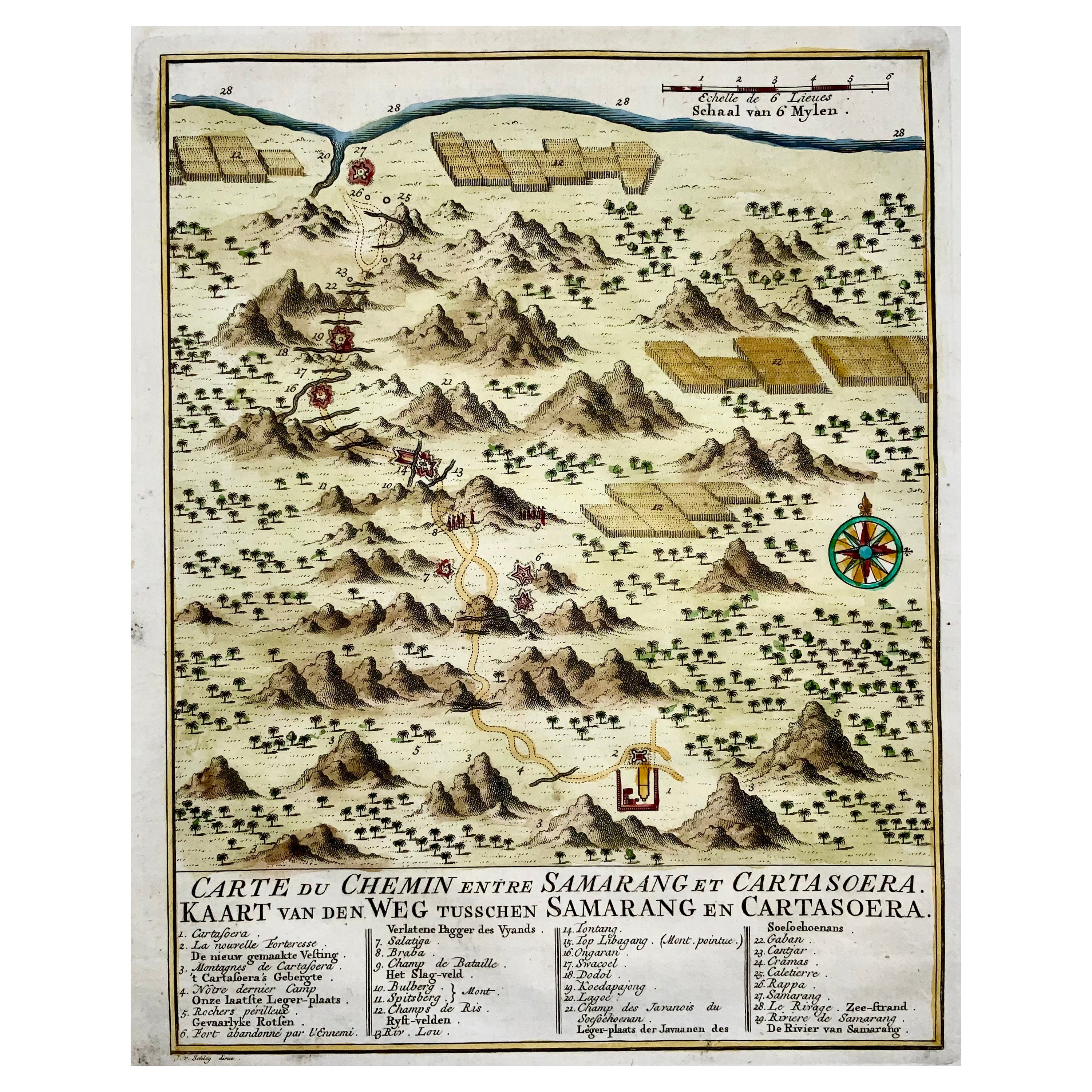
View AllMap of Indonesia, Semarang, Kartasoera, Soerabaya by Schley
By Jakob van der Schley
Located in Norwich, GB
'Carte du Chemin entre Samarang et Cartasoera, kaart van den weg tusschen Samarang en Cartasoera'
Map of the Road between Semarang and Kartasura by Van Schley.
Published 1763.
...
Category
Antique 1760s Indonesian Georgian Prints
Materials
Paper

1750 Schaffhausen, Seutter, Large and Detailed Map Switzerland
By Matthew Seutter
Located in Norwich, GB
Sandrart Joachim, von (1606-1688)
Effigies antiquae Romae. redacta a Pyrrho Ligorio Romano, per XIIII Regiones, in quas Urbem divisit Imp. Caesar August.
Nuremberg, Germany, pu...
Category
Antique 1670s Italian Baroque Prints
Materials
Paper
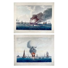
1797 Set of 2 Large Aquatints, Maritime, Explosion of the 'HMS' Boyne
By John William Edy
Located in Norwich, GB
On offer two superb and large aquatints (with original hand color) depicting the “Explosion on, and Sinking of Her Majesty’s Ship BOYNE”
Plate 1. “View of His Majesty's Ship Boyne...
Category
Antique 1790s British Georgian Prints
Materials
Paper
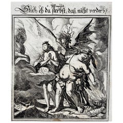
Broadside Dance of Death, “Stirb…”, Conrad Meyer, Master Engraving
By J. Meyer
Located in Norwich, GB
Dance of Death Broadside
Todtentanz Einblattdruck
Meyer, Conrad 1618-1689
Stirb, eh du sterbst, dass nicht verderbst
[Der Todesengel zwischen Laste...
Category
Antique 1650s Swiss Renaissance Prints
Materials
Paper
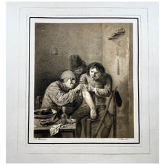
1810c Medicine, Surgeon, N. Strixner after A. Brouwer, incunabula of lithography
Located in Norwich, GB
A. Brouwer pinx. N. Strixner del.
Village Surgeon (The Feeling)
A surgeon dressing the wound of a grimacing patient.
61 x 45 cm; Image: 29.3 x 26.3 cm
Published c 1810
Stone lit...
Category
Antique 1810s German Neoclassical Prints
Materials
Paper
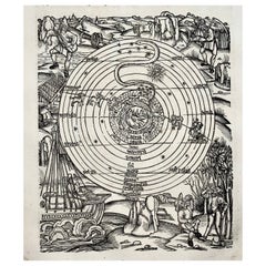
1517 Farming Calendar, Master of the Grüninger Workshop, Master Woodcut
By Albrecht Dürer
Located in Norwich, GB
Original from 1515
A pivotal and iconic calendar woodcut from 1517 and first used in the 1502 of Sebastian Brandt’s edition of the works of Vergil.
The four books of The Georgi...
Category
Antique 16th Century Prints
Materials
Paper
You May Also Like
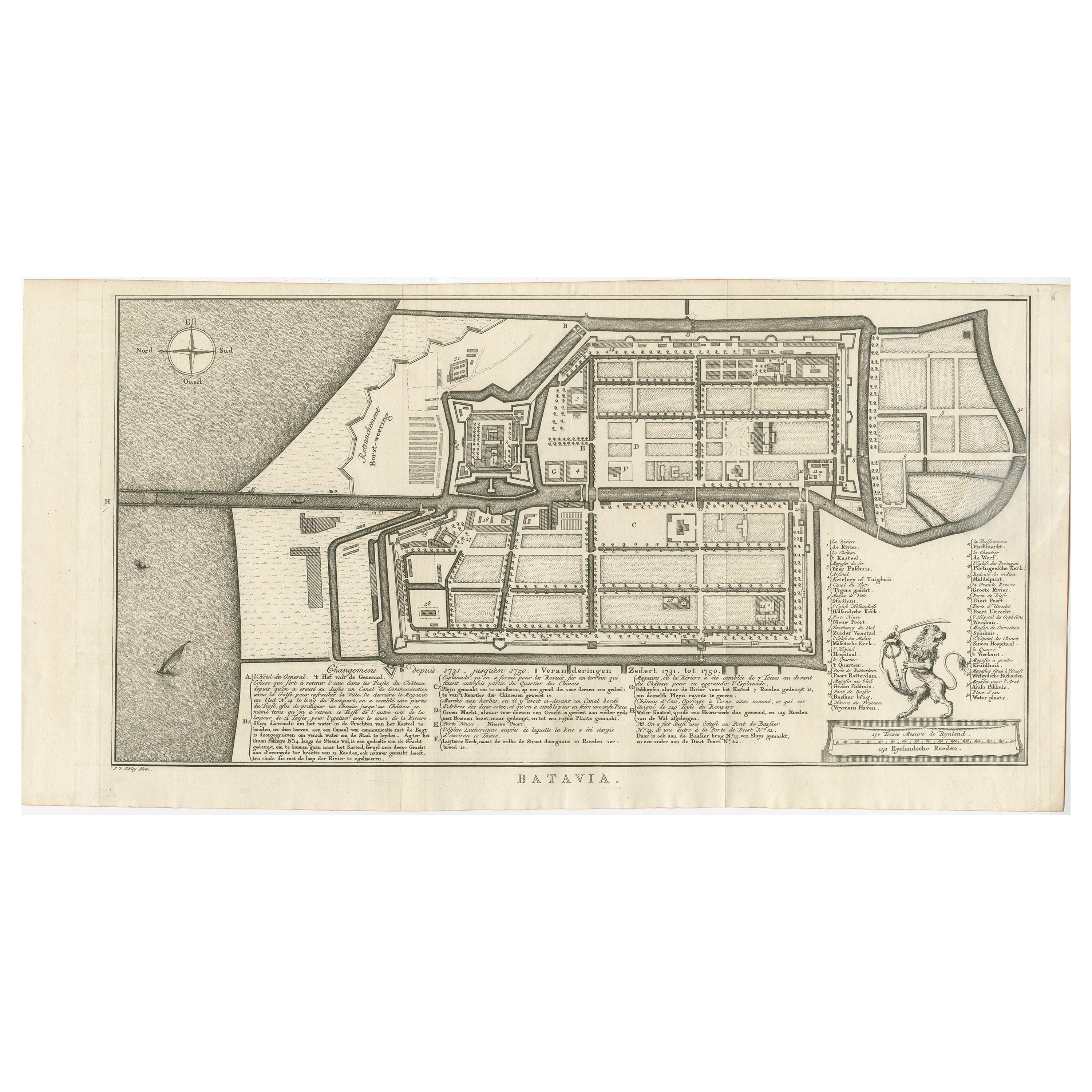
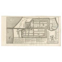
Antique Map of Batavia by Van Schley 'c.1750'
Located in Langweer, NL
Antique map titled 'Batavia'. Original antique map of Batavia, Jakarta, Indonesia. This print originates from the Dutch edition of Prevost's 'Histoire Generale des Voyages' (Paris 17...
Category
Antique Mid-18th Century Prints
Materials
Paper
$415 Sale Price
20% Off
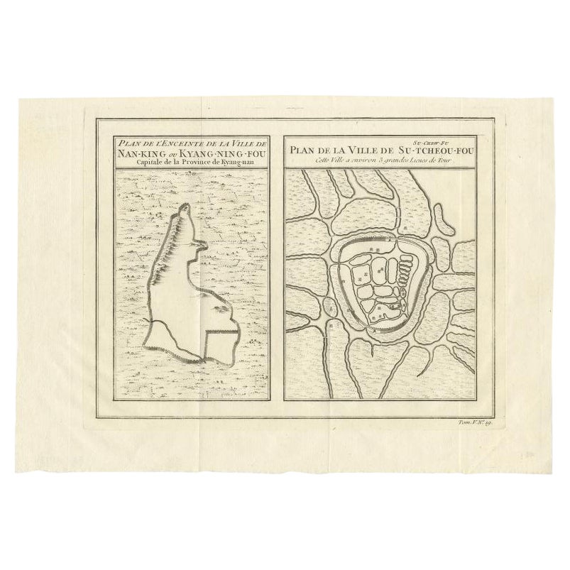
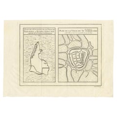
Antique Map of Cities of the Jiangsu Region in China, c.1760
By Jacques-Nicolas Bellin
Located in Langweer, NL
Antique map titled 'Plan de l' Enceinte de la Ville de Nan-King ou Kyang-Ning-Fou et plan de la ville de Su-Tcheou-Fou.' A map of the city of Nanking or Nanjing and a second map show...
Category
Antique 18th Century Maps
Materials
Paper
$184 Sale Price
20% Off
Antique Map of Cities of the Province of Shanxi in China, 1749
By Jacques-Nicolas Bellin
Located in Langweer, NL
Antique print titled: 'Lan-Tcheou ou Lan-Chew dan la province Chensi; Can Tcheou ou Kan-Chew dan la province de Chensi; Tchin-Ywe-Fou ou Chin-Ywen-Fu dans la province de Koei-Tcheou ...
Category
Antique 18th Century Maps
Materials
Paper

$230 Sale Price
20% Off
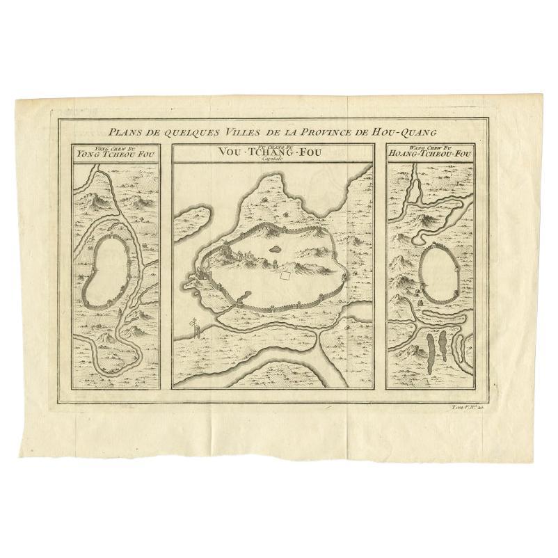
Antique Map of Cities in the Hubei and Hunan Provinces of China, 1755
By Jacques-Nicolas Bellin
Located in Langweer, NL
Antique print titled 'Plans de Quelques villes de la province de Hou-Quang.' Three bird's-eye view plans of walled cities in what are now China's Hubei (Hou-Quang) and Hunan Province...
Category
Antique 18th Century Maps
Materials
Paper

$267 Sale Price
20% Off
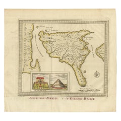
Anbtique Map of the Island of Bali by Van Schley '1755'
Located in Langweer, NL
Antique map titled 'Isle de Baly - 't Eiland Baly'. Beautiful original antique map of Bali, Indonesia. Depicts the island from the north with Java to the l...
Category
Antique Mid-18th Century Maps
Materials
Paper
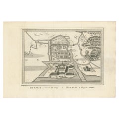
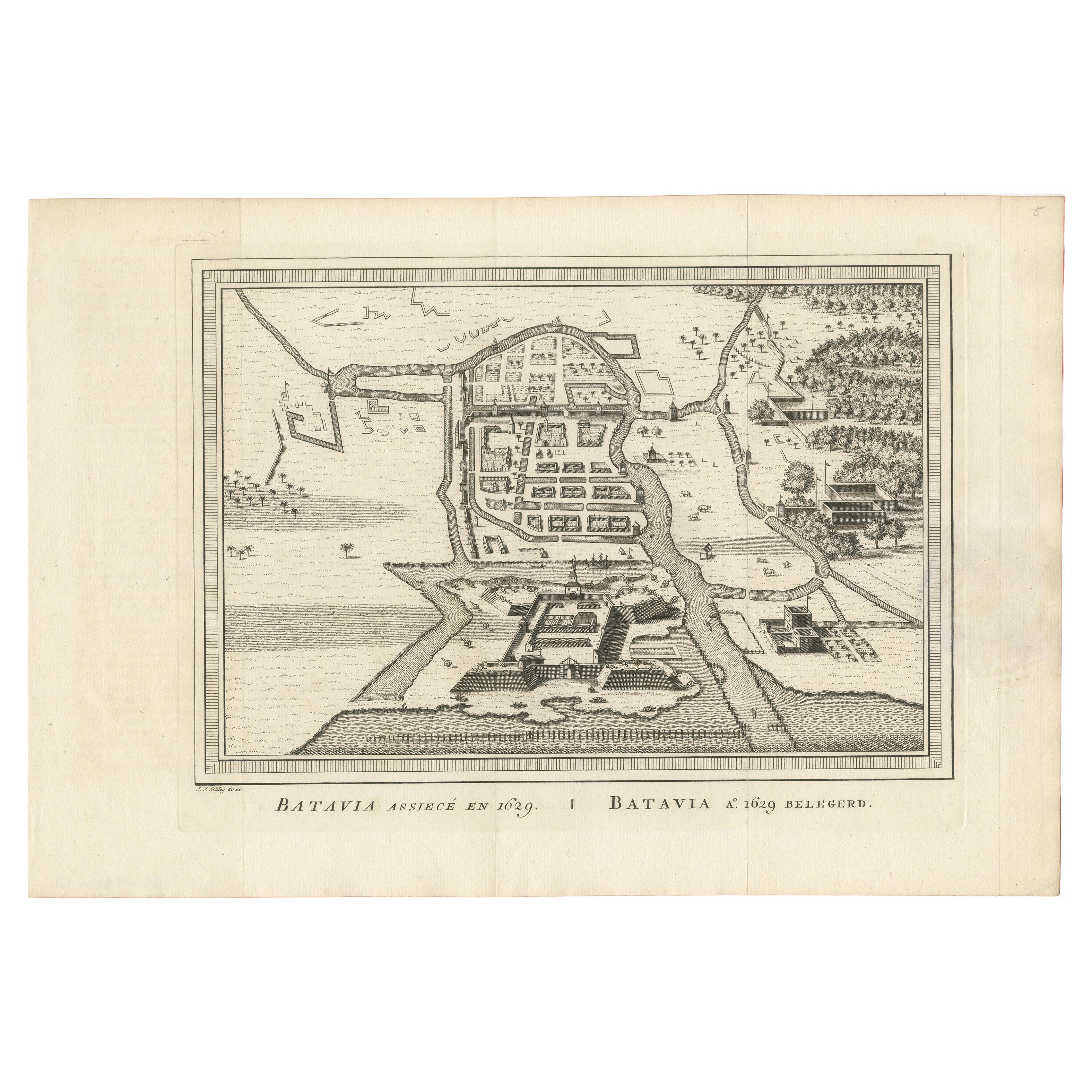
Antique Map of the Siege of Batavia by Van Schley 'c.1750'
Located in Langweer, NL
Antique map titled 'Batavia assiecé en 1629 - Batavia 1629 belegerd'. Bird's eye view map of the siege of Batavia in 1629, Jakarta, Indonesia. This print originates from the Dutch ed...
Category
Antique Mid-18th Century Prints
Materials
Paper