Items Similar to Circa 1950 original illustrated map by André Lesot for "Carte de la Manche"
Want more images or videos?
Request additional images or videos from the seller
1 of 8
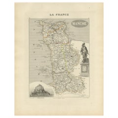
André LesotCirca 1950 original illustrated map by André Lesot for "Carte de la Manche"Circa 1950
Circa 1950
$653.23
£489.64
€550
CA$903.32
A$983.48
CHF 525.15
MX$11,872.17
NOK 6,602.05
SEK 6,140.68
DKK 4,190.40
About the Item
The circa 1950 original illustrated map by André Lesot for "Carte de la Manche" is a significant piece that highlights both artistic design and geographic representation. Created during the mid-20th century, this map reflects a period of renewed interest in regional pride and identity in post-war France.
Lesot, a celebrated French artist known for his work in cartography, crafted this map to serve both as an informative tool and as a piece of visual art. The "Carte de la Manche" focuses on the Manche region, which includes northern France’s Normandy coast, offering both geographic details and insights into the area’s history, culture, and natural landscape.
The map was created at a time when illustrated maps were gaining popularity, particularly as decorative and educational pieces. These maps combined geographic precision with artistic flair, appealing to both travelers and collectors alike. Lesot’s approach to cartography merged functionality with an expressive style, making the map both a practical resource and a visual tribute to the Manche region.
Produced in the early 1950s, this "Carte de la Manche" is a reflection of a period in France when there was a resurgence of interest in national pride, regional identities, and artistic expressions. The map is representative of the mid-century style, which was characterized by clear, easy-to-read design, with a focus on both artistic detail and geographic accuracy.
As an important piece of French cartographic history, the "Carte de la Manche" stands out for its combination of utility and aesthetic value. Today, it remains a collectible item for those interested in the history of French maps, regional culture, and mid-century design.
Original poster
Map - Manche - France
- Creator:André Lesot
- Creation Year:Circa 1950
- Dimensions:Height: 28.75 in (73 cm)Width: 21.26 in (54 cm)
- Medium:
- Period:
- Condition:Good condition, traces of folds, on linen.
- Gallery Location:PARIS, FR
- Reference Number:1stDibs: LU1792215440232
About the Seller
5.0
Gold Seller
Premium sellers maintaining a 4.3+ rating and 24-hour response times
Established in 2021
1stDibs seller since 2022
194 sales on 1stDibs
Typical response time: 1 hour
- ShippingRetrieving quote...Shipping from: PARIS, France
- Return Policy
More From This Seller
View All1947 original map Gouvernement Généraux du Poitou, du Pays d'Aunis
Located in PARIS, FR
The 1947 original map Gouvernement Généraux du Poitou, du Pays d'Aunis et de Saintonge Angoumois, created by Louis Larmat and printed by Dorel in Paris, is a beautifully detailed cartographic representation of a historically significant region in western France. This map, part of Larmat’s extensive body of work, is known for its artistic craftsmanship and geographical precision, offering a comprehensive view of the historical administrative regions of Poitou, Aunis, Saintonge, and Angoumois, which played key roles in the political and cultural history of France.
Louis Larmat is celebrated for his contributions to cartography, particularly for his ability to merge historical context, topographical detail, and aesthetic elegance in his maps. His works, especially those focusing on the vinicultural regions of France, are highly respected for their accuracy and artistry. This particular map, although focusing on a more political and historical aspect rather than the wine regions he is most famous for, continues his tradition of detailed regional documentation. Larmat’s cartographic works often transcended the realm of simple geographical depiction, becoming historical documents that encapsulate the cultural essence of the regions they portray.
This map illustrates the general governments (administrative divisions) of the provinces of Poitou, Aunis, Saintonge, and Angoumois, regions that are steeped in history. These areas, situated along France’s western coastline, have been integral to the country’s political, economic, and cultural development over centuries. The region of Poitou, for example, is historically known as the birthplace of Eleanor of Aquitaine...
Category
1940s Prints and Multiples
Materials
Paper, Lithograph

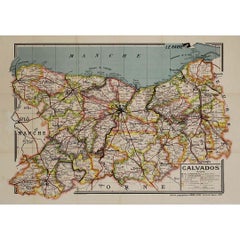
Circa 1950 original map poster of Calvados, designed by André Lesot - Normandy
Located in PARIS, FR
This circa 1950 original map poster of Calvados, designed by André Lesot, is a beautifully detailed representation of this historic region in Normandy, France. Produced by Éditions G...
Category
1950s Prints and Multiples
Materials
Linen, Paper, Lithograph
Circa 1950 original illustrated map for "Carte France autour de Bordeaux"
Located in PARIS, FR
The circa 1950 original illustrated map for "Carte France autour de Bordeaux" is an excellent representation of mid-20th century cartography, focusing on the area surrounding Bordeau...
Category
1950s Prints and Multiples
Materials
Linen, Paper
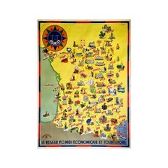
Circa 1935 map illustrated by André Giroux of the P.O Midi railroad network.
Located in PARIS, FR
Very beautiful map illustrated by André Giroux of the P.O Midi railroad network.
The railway company from Paris to Orleans and the Midi (PO Midi) is the n...
Category
1930s Prints and Multiples
Materials
Linen, Paper, Lithograph
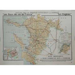
1947 original map "Le Cognac Bois ordinaires & Bois communs" by Larmat
Located in PARIS, FR
The 1947 original map Atlas de la France Vinicole - Les Eaux-de-vie de France - Le Cognac Bois Ordinaires & Bois Communs dits à Terroir, created by Louis Larmat and printed by Dorel ...
Category
1940s Prints and Multiples
Materials
Paper, Lithograph
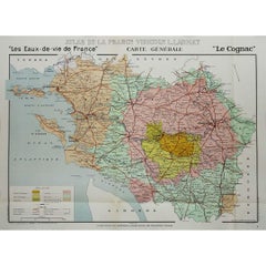
1947 original map "Les eaux-de-vie de France - Le Cognac" by Larmat
Located in PARIS, FR
The 1947 original map Atlas de la France vinicole - Les eaux-de-vie de France - Le Cognac, created by Louis Larmat and printed by Dorel in Paris, is a fascinating and detailed cartog...
Category
1940s Prints and Multiples
Materials
Paper, Lithograph
You May Also Like
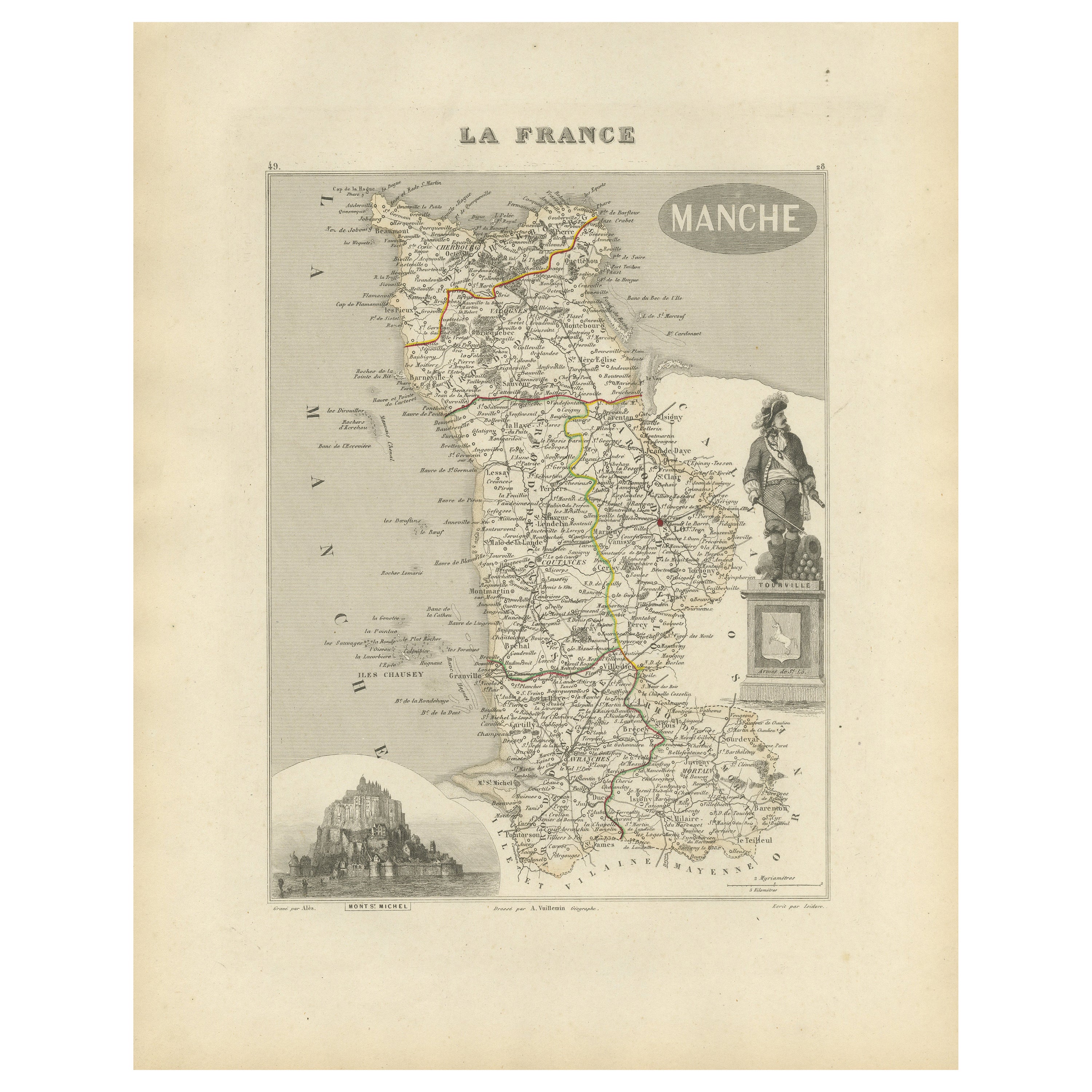
Antique Engraved Map of Manche with Mont Saint-Michel, France, circa 1850
Located in Langweer, NL
Antique Map of Manche, France – Mont-St-Michel and Cherbourg Region – c.1850
This highly decorative mid-19th century map of Manche, engraved by A. Vuillemin and published by Levasse...
Category
Antique Mid-19th Century French Maps
Materials
Paper
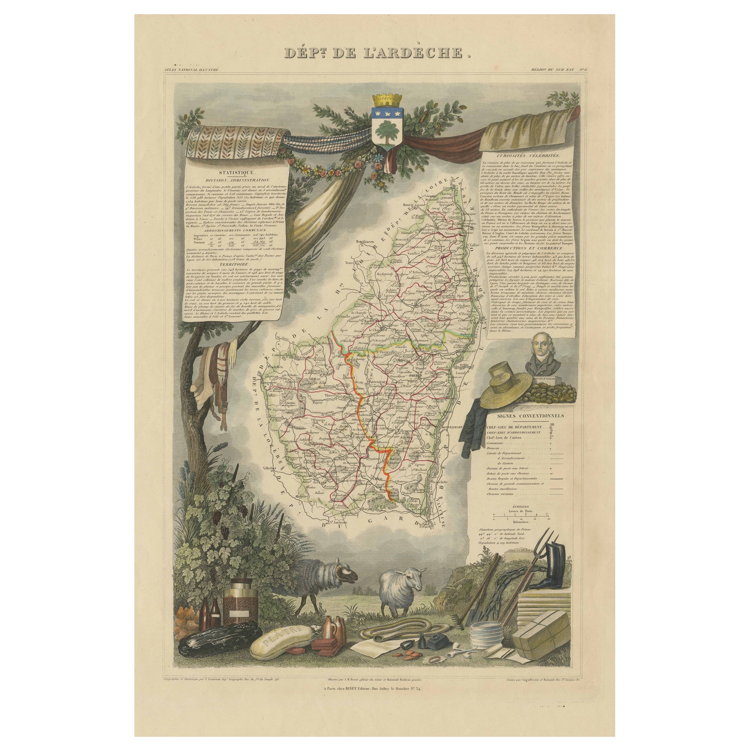
Old Map of the French Department of Ardèche, France
By Victor Levasseur
Located in Langweer, NL
Antique map titled 'Dépt. de l'Ardèche'. Map of the Department of Ardèche, France. This region is known for its fine wines, agriculture, distilled spirits, and cheese. The capital ci...
Category
Antique Mid-19th Century Maps
Materials
Paper
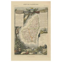
$323 Sale Price
20% Off
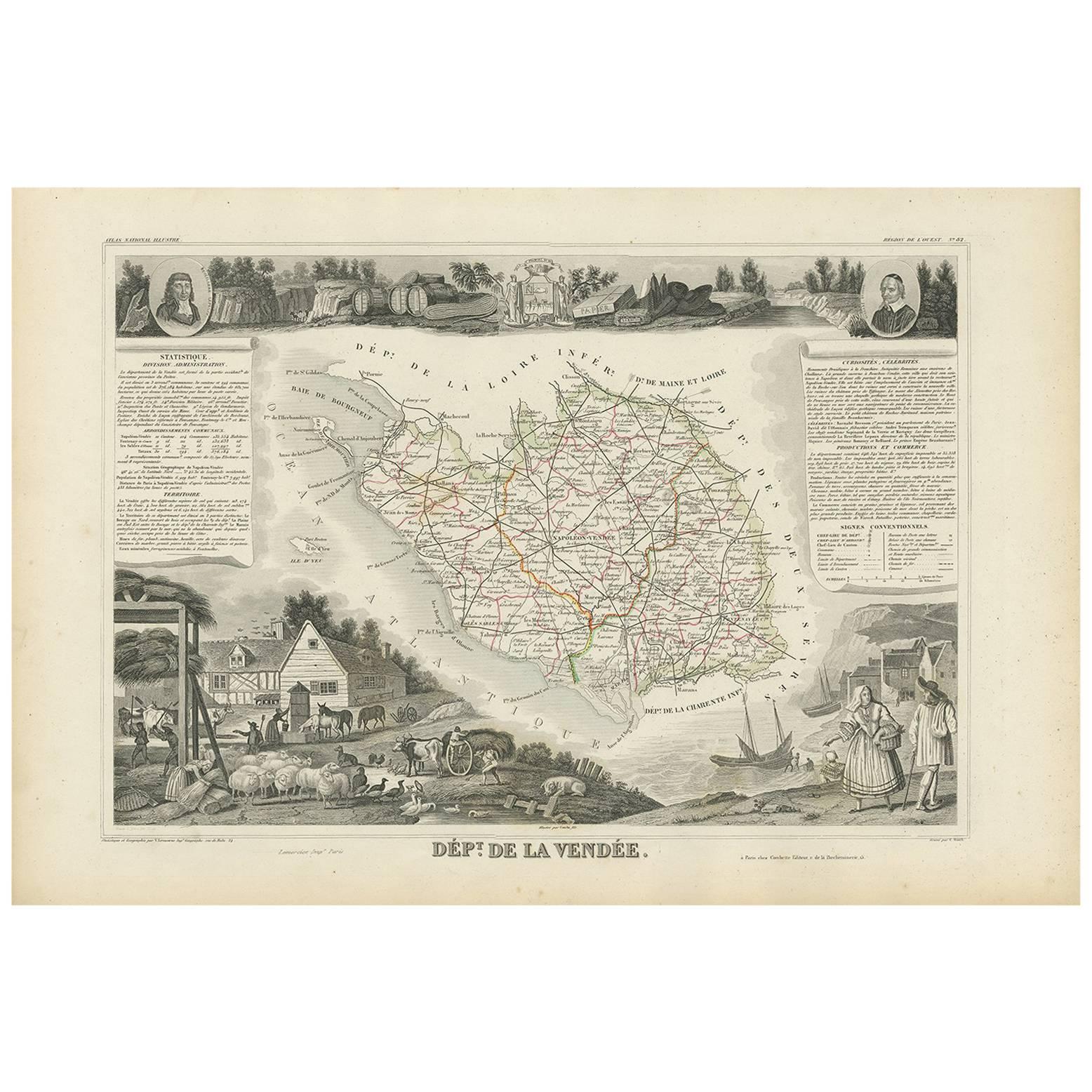
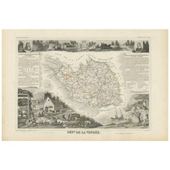
Antique Map of Vendée ‘France’ by V. Levasseur, 1854
By Victor Levasseur
Located in Langweer, NL
Antique map titled 'Dépt. de la Vendée'. Map of the French department of Vendee, France.
Vendee is home to a number of small vineyards around the communes of Vix, Brem, Pissotte an...
Category
Antique Mid-19th Century French Maps
Materials
Paper
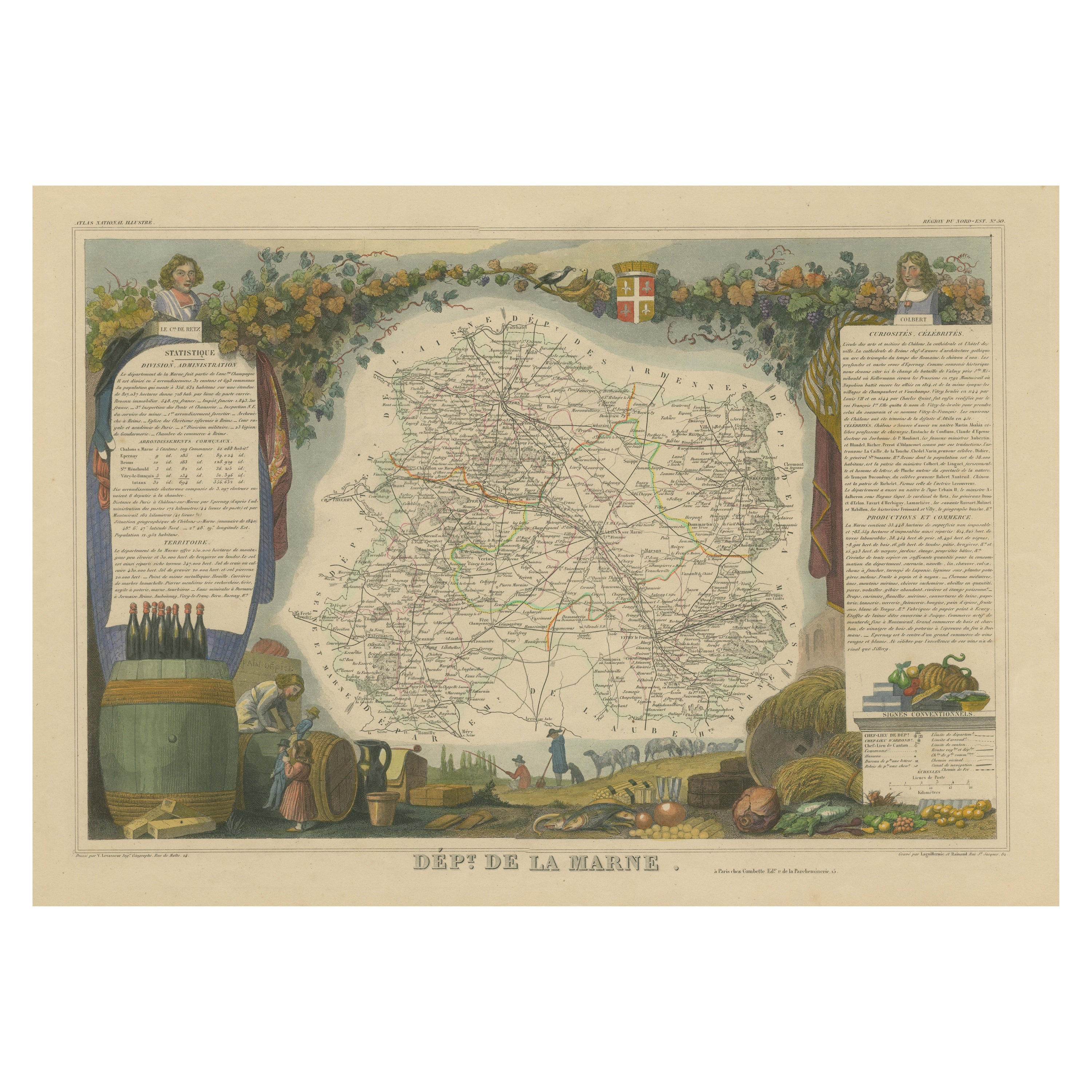
Hand Colored Antique Map of the Department of Marne, France
By Victor Levasseur
Located in Langweer, NL
Antique map titled 'Dépt. de la Marne'. Map of the French department of Marne, France. This department is home to the Champagne region where the world's finest sparkling wine is prod...
Category
Antique Mid-19th Century Maps
Materials
Paper
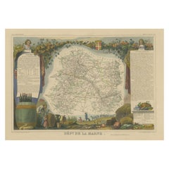
$323 Sale Price
20% Off
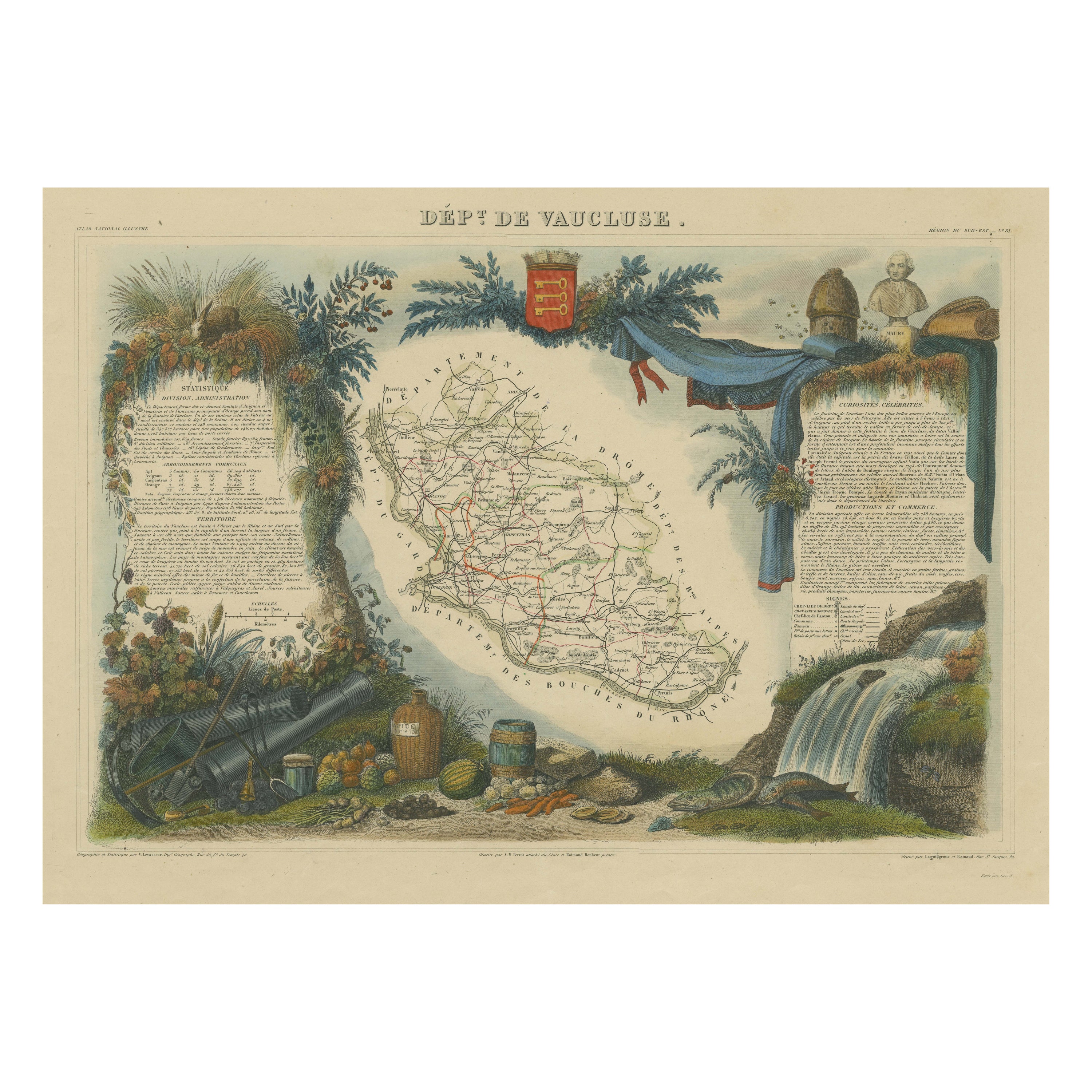
Hand Colored Antique Map of the Department of Vaucluse, France
By Victor Levasseur
Located in Langweer, NL
Antique map titled 'Dépt de Vaucluse'. Map of the French department of Vaucluse, France. Vaucluse is the center of wine production in the southern Rhone. Some of the smartest wines in France can be found here. There is also a very strong movement towards the adoption of organic and biodynamic viticulture and natural wine making...
Category
Antique Mid-19th Century Maps
Materials
Paper
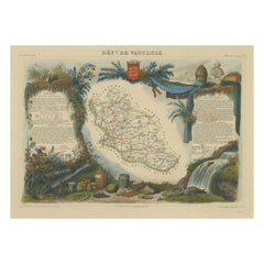
$323 Sale Price
20% Off
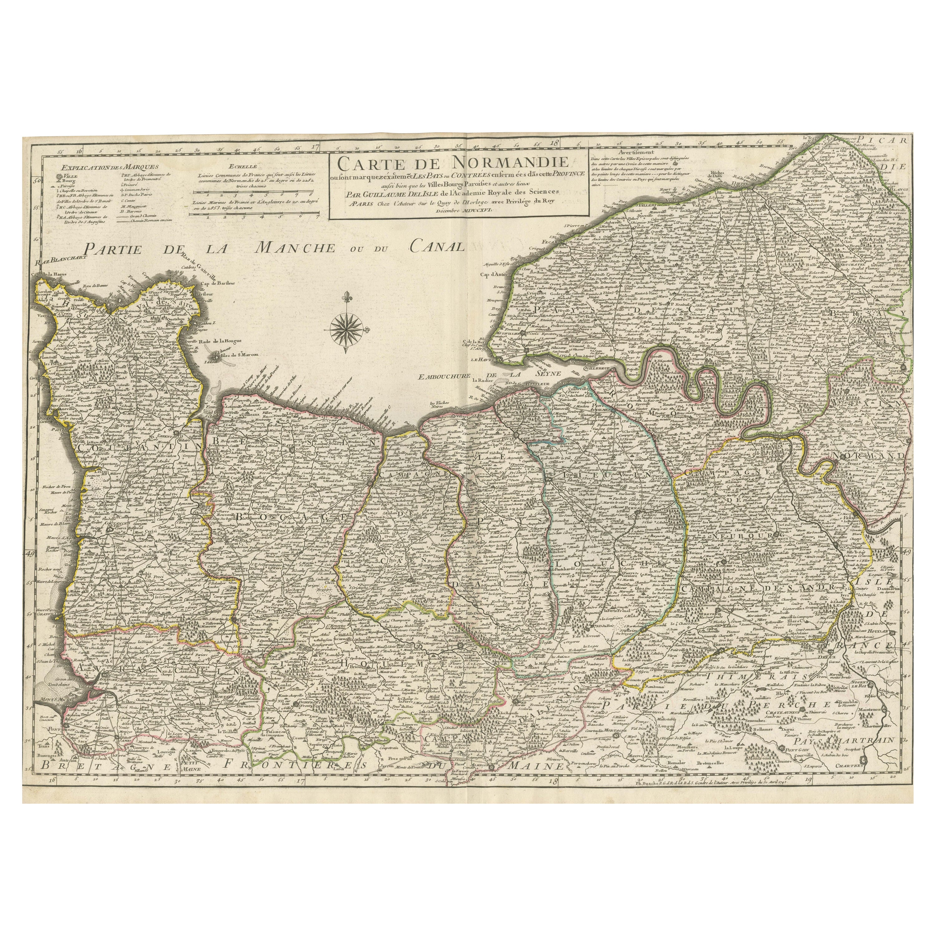
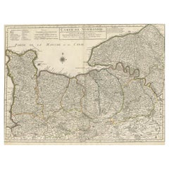
Original Antique Map of Normandy, France
Located in Langweer, NL
Antique map titled 'Carte de Normandie (..)'. Attractive map of Normandy, France. it depicts the former French Duchy of Normandy, covers the region fro...
Category
Antique Mid-18th Century Maps
Materials
Paper
$750 Sale Price
20% Off
More Ways To Browse
The Vintage Map
Illustrated Map
Vintage French Map
Vintage Illustrated Maps
Mid Century Poster Design
Warhol Campbell Soup Print
Woodblock Prints Contemporary
Alpine Poster
Andy Warhol Hand Signed
Ari Gradus
Bank Posters
Basquiat Crown
Dead Body
Dran Art
Drowning Girl
Fisherman Etching
German Judaica
Gilbert And George