Items Similar to Sala, Map from "Civitates Orbis Terrarum" - by F.Hogenberg - 1575
![[Civitates Orbis Terrarum]Map of Cefal - Etching by G. Braun/F. Hogenberg - 1575](https://a.1stdibscdn.com/georg-braun-and-franz-hogenberg-prints-works-on-paper-civitates-orbis-terrarummap-of-cefal-etching-by-g-braun-f-hogenberg-1575-for-sale/a_6503/a_137919521705507440775/J_71845_georg_braun_franz_hogenberg_civitates_orbis_terrarum_map_of_ce_1_master.jpg)
Want more images or videos?
Request additional images or videos from the seller
1 of 2
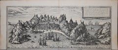
Franz HogenbergSala, Map from "Civitates Orbis Terrarum" - by F.Hogenberg - 15751575
1575
$416.17
$594.5230% Off
£312.16
£445.9430% Off
€350
€50030% Off
CA$580.97
CA$829.9530% Off
A$629.26
A$898.9430% Off
CHF 333.28
CHF 476.1230% Off
MX$7,613.05
MX$10,875.7830% Off
NOK 4,189.86
NOK 5,985.5230% Off
SEK 3,905.84
SEK 5,579.7830% Off
DKK 2,666.24
DKK 3,808.9130% Off
About the Item
"Sala", from the collection "Civitates Orbis Terrarum", Cologne, T. Graminaeus, 1575.
The “Civitates Orbis Terrarum” (Atlas of Cities of the World) was the second oldest printed atlas in the history of world cartography and the first atlas totally dedicated to topographical views. The first volume of this collection was published at Cologne in 1572; the others following in 1575, 1581, 1588 and 1598. The sixth and final volume appeared in 1617, just before the extensive devastation wreaked by the Thirty Years’War.
“The most original and magnificent of all city-atlases, which drew on the work of accomplished topographical artists; and…reproduced it in pictorial compositions of great charm and individuality”. R.A.Skelton
This artwork is shipped from Italy. Under existing legislation, any artwork in Italy created over 70 years ago by an artist who has died requires a licence for export regardless of the work’s market price. The shipping may require additional handling days to require the licence according to the final destination of the artwork.
- Creator:Franz Hogenberg (1540 - 1590, Flemish)
- Creation Year:1575
- Dimensions:Height: 5.52 in (14 cm)Width: 6.3 in (16 cm)Depth: 0.04 in (1 mm)
- Medium:
- Period:
- Condition:Insurance may be requested by customers as additional service, contact us for more information.
- Gallery Location:Roma, IT
- Reference Number:Seller: J-719521stDibs: LU65036159592

Franz Hogenberg
Braun and Hogenberg's 'The Civitates Orbis Terrarum' was the second atlas of maps ever published and the first atlas of cities and towns of the world. It is one of the most important books published in the 16th century. Most of the maps in the atlas were engraved by Franz Hogenberg and the text, with its descriptions of the history and additional factual information of the cities, was written by a team of writers and edited by Georg Braun. The work contained 546 bird-eye views and map views of cities and towns from all over the world. It gave graphic representation of the main features of the illustrated cities and towns, including the buildings and streets. Although the ordinary buildings are stylized, the principal buildings are reproduced from actual drawings created on location. The principal landmarks and streets can still be recognized today. In addition, the maps often include the heraldic arms of the city, the nature of the surrounding countryside, the important rivers, streams and harbors, even depicting stone bridges, wooden pontoons, flat-bottomed ferries, ships and working boats, wharves and jetties, as well as land-based activities, including horsemen, pedestrians, wagons, coaches, and palanquins. Small vignettes are often included which illustrate the trade, occupations and habits of the local inhabitants, such as agriculture, paper-making and textiles, as well as local forms of punishment, such as gibbets, wheels, floggings etc. Large figures dressed in their local costume are often presented out of proportion in the foreground. The aim of the authors was to give as much information as possible in a pleasing visual form. They succeeded in creating maps that were both informative and decorative works of art. The atlas is a wonderful glimpse of life in medieval Europe. Georg Braun (1541-1622) was German Catholic cleric who was born and who died in Cologne, Germany. He was the principal editor of 'The Civitates Orbis Terrarum', acquiring the tables, hiring the artists, and composing the texts. Abraham Ortelius, whose Theatrum Orbis Terrarum of 1570 was the first atlas of maps ever published, assisted Braun in his compilation of the details and maps for the atlas. The Civitates was intended as a companion for the Ortellius' Theatrum, as suggested by the similarity in the titles. Braun was the only survivor of the original team to live to see the publication of last volume (VI) in 1617. Franz Hogenberg (1535-1590) was a Flemish and German painter, engraver, and mapmaker. He was born in Mechelen (also known as Malines) in Flanders, the son of an engraver. After being expelled from Antwerp by the Duke of Alva, he moved to London and then eventually to Cologne, Germany, where he met Georg Braun and Abraham Ortellius. He engraved most of the plates for Ortelius's Theatrum and the majority of those in the Civitates. Many believe that he was responsible for originating the Civitates project.
About the Seller
4.9
Platinum Seller
Premium sellers with a 4.7+ rating and 24-hour response times
1stDibs seller since 2017
7,837 sales on 1stDibs
Typical response time: 1 hour
- ShippingRetrieving quote...Shipping from: Roma, Italy
- Return Policy
More From This Seller
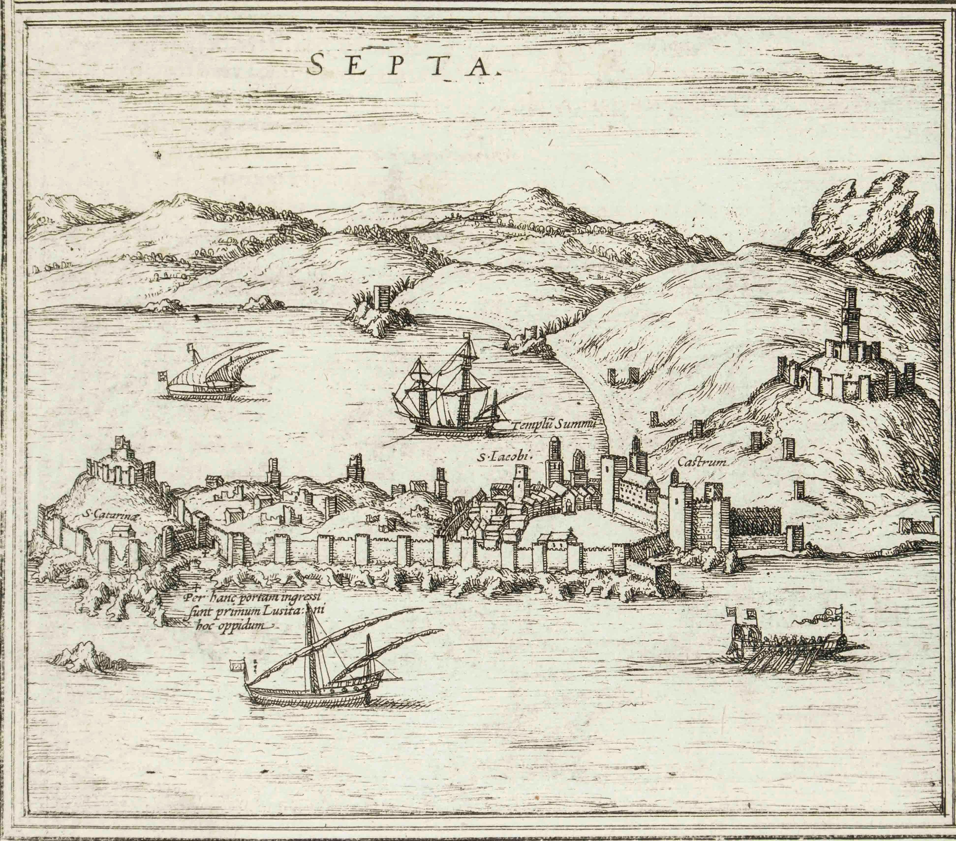
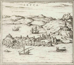
View AllSepta, Map from "Civitates Orbis Terrarum" - by F.Hogenberg - 1575
By Franz Hogenberg
Located in Roma, IT
"Septa", from the collection "Civitates Orbis Terrarum", Cologne, T. Graminaeus, 1575.
The “Civitates Orbis Terrarum” (Atlas of Cities of the World) was the second oldest printed ...
Category
16th Century Figurative Prints
Materials
Etching, Aquatint
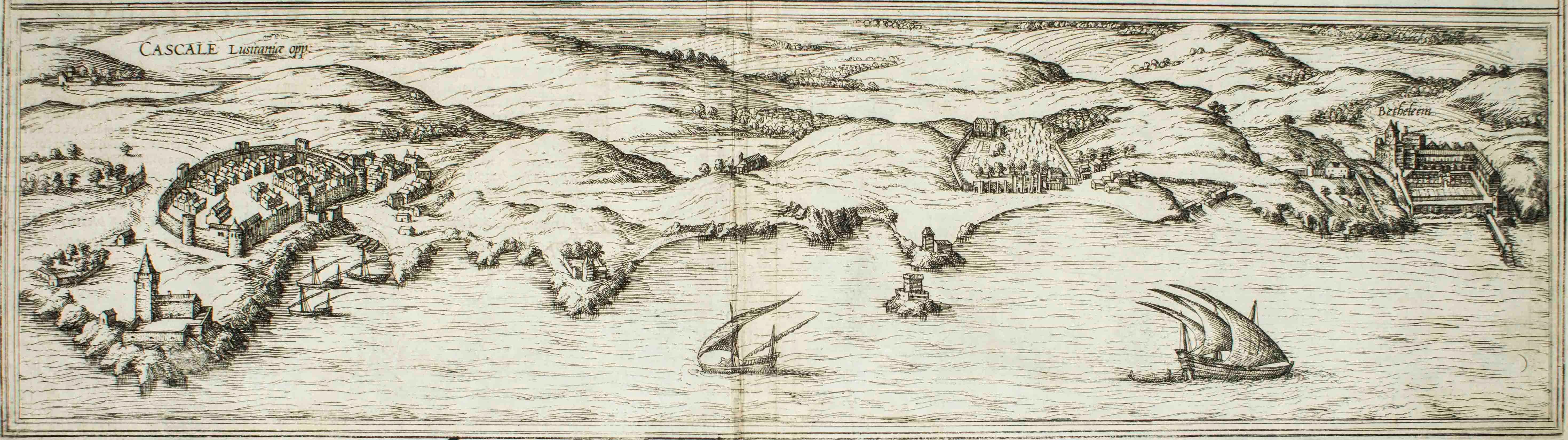
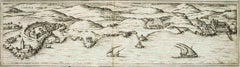
Cascale, Map from "Civitates Orbis Terrarum" - by F. Hogenberg - 1575
By Franz Hogenberg
Located in Roma, IT
Braun G., Hogenberg F., Cascale, from the collection Civitates Orbis Terrarum, Cologne, T. Graminaeus, 1572-1617.
Good conditions expect tue usual central fold.
The “Civitates Orbis...
Category
16th Century Figurative Prints
Materials
Etching, Aquatint
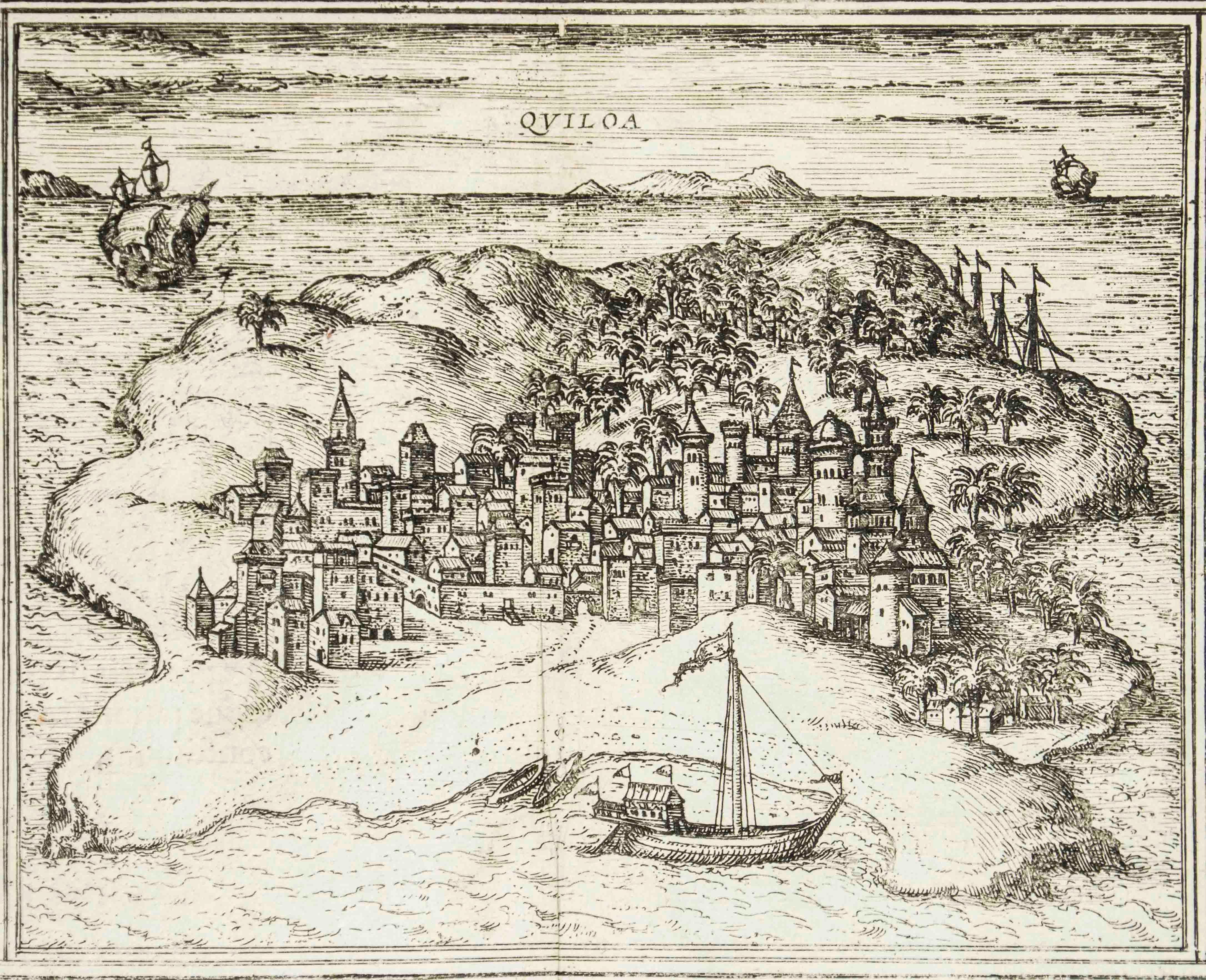
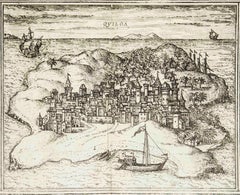
Quiloa, Map from "Civitates Orbis Terrarum" - by F.Hogenberg - 1575
By Franz Hogenberg
Located in Roma, IT
"Quiloa", from the collection "Civitates Orbis Terrarum", Cologne, T. Graminaeus, 1575.
The “Civitates Orbis Terrarum” (Atlas of Cities of the World) was the second oldest printed...
Category
16th Century Figurative Prints
Materials
Etching, Aquatint
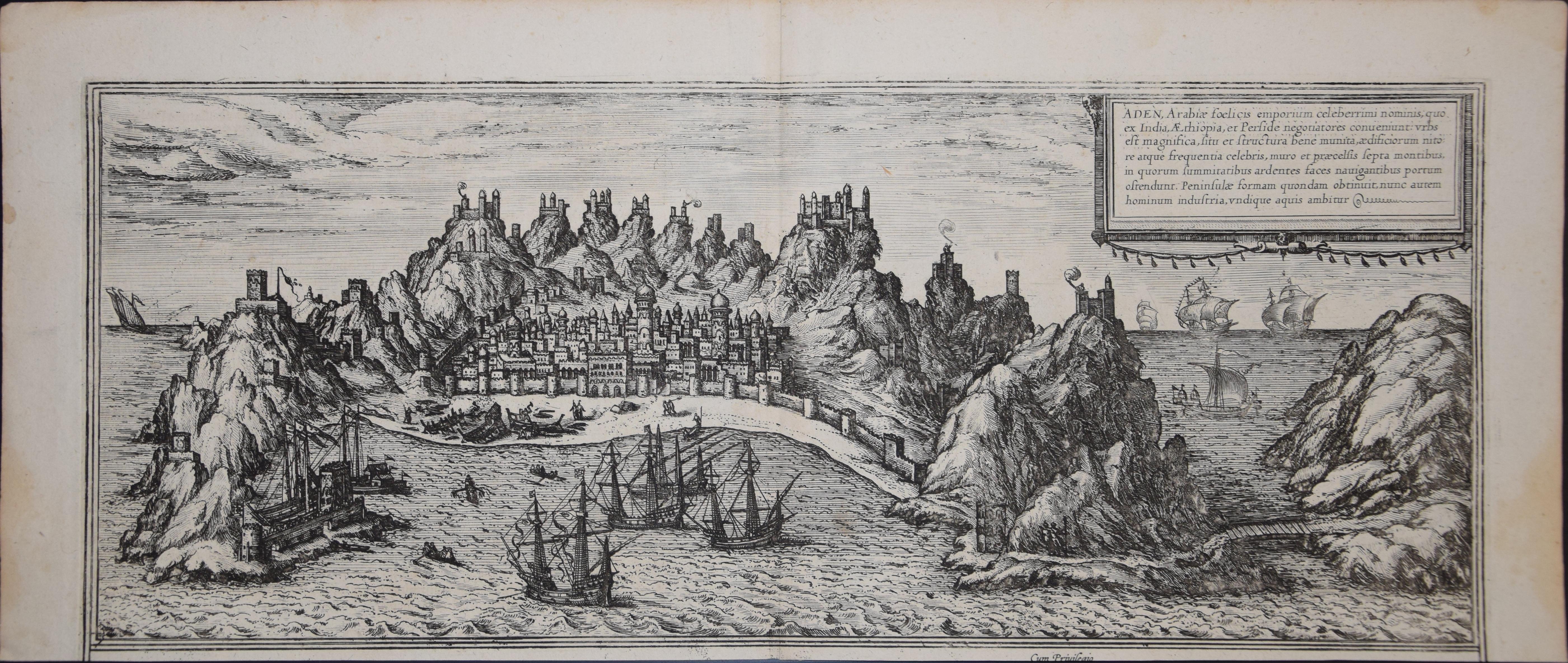
Aden, Map from "Civitates Orbis Terrarum" - by F. Hogenberg - 1575
By Franz Hogenberg
Located in Roma, IT
Braun G., Hogenberg F., Aden, from the collection Civitates Orbis Terrarum, Cologne, T. Graminaeus, 1572-1617.
Good conditions except some stains on margins and a central fold.
The ...
Category
16th Century Figurative Prints
Materials
Etching, Aquatint
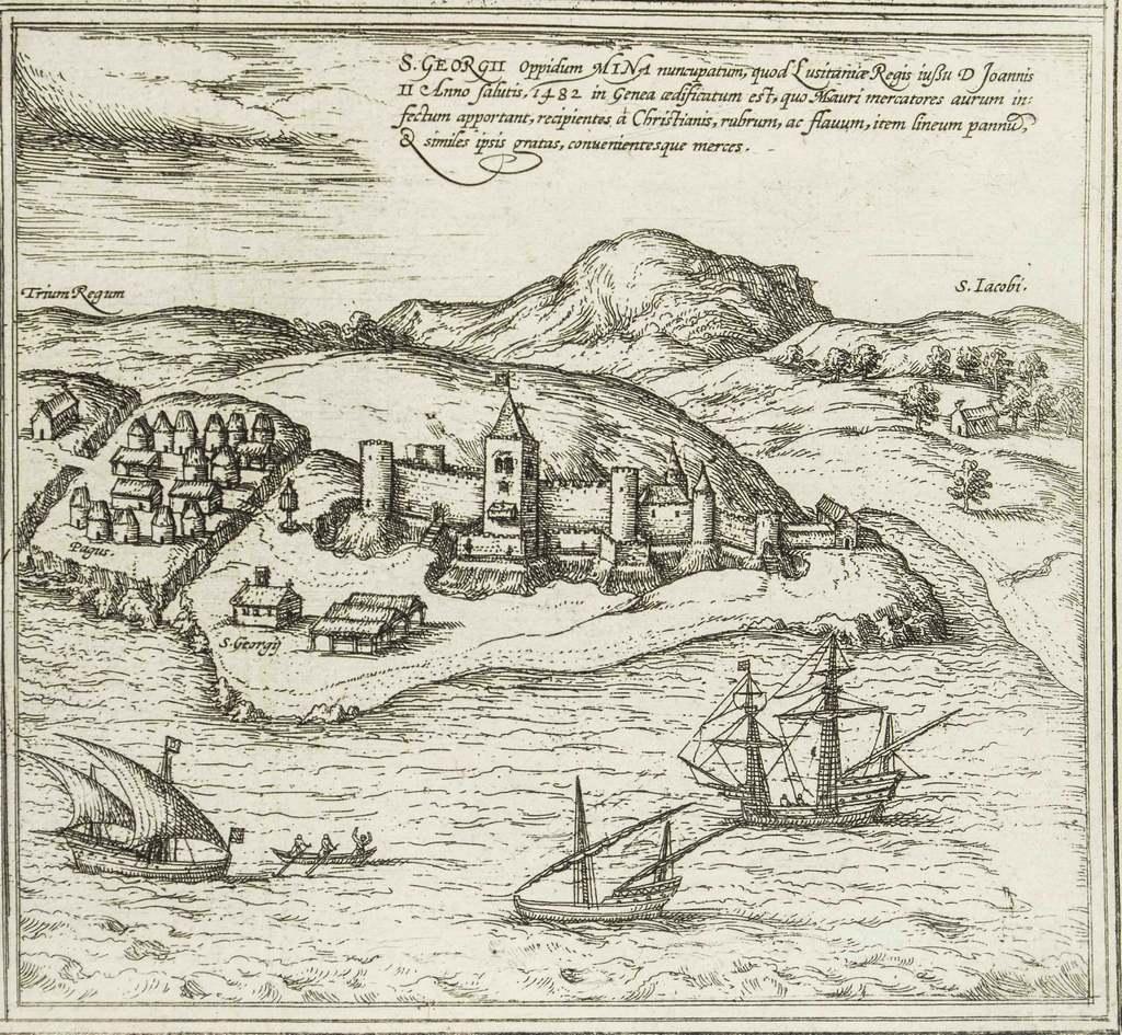
Map of San Georgi - Etching by G. Braun/F. Hogenberg - 1575
Located in Roma, IT
Etching by Georg Braun and Frans Hogenberg, realized in 1575 and belonging to the Suite "Civitates Orbis Terrarum".
The first volume of the Civitates Orbis Terrarum was published in ...
Category
16th Century Modern Figurative Prints
Materials
Etching
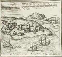
[Civitates Orbis Terrarum]Map of Cefal - Etching by G. Braun/F. Hogenberg - 1575
Located in Roma, IT
Etching by Georg Braun and Franz Hogenberg, belonging to the "Civitates Orbis Terrarum".
Good condition.
The first volume of the Civitates Orbis Terrarum was published in Cologne in ...
Category
16th Century Contemporary Figurative Prints
Materials
Etching
![[Civitates Orbis Terrarum]Map of Cefal - Etching by G. Braun/F. Hogenberg - 1575](https://a.1stdibscdn.com/georg-braun-and-franz-hogenberg-prints-works-on-paper-civitates-orbis-terrarummap-of-cefal-etching-by-g-braun-f-hogenberg-1575-for-sale/a_6503/a_137919521705507440775/J_71845_georg_braun_franz_hogenberg_civitates_orbis_terrarum_map_of_ce_1_master.jpg?width=240)
You May Also Like
16th c. woodcut map - Tabula Asiae Vlll
By Sebastian Münster
Located in Santa Monica, CA
SEBASTIAN MUNSTER (1488-1652)
ASIAE TABVLA Vlll 1540 (45)
Woodcut from Munster's edition of Geographia Universalis, Basel, Henri Petri. 1545 edit...
Category
16th Century Old Masters Landscape Prints
Materials
Woodcut

$950 Sale Price
29% Off
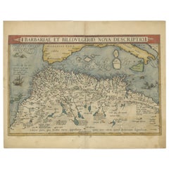
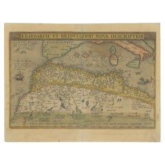
Antique Map of North Africa by Ortelius, c.1600
Located in Langweer, NL
Antique map titled 'Barbariae et Biledulgerid nova descriptio'.
Old map of coastal North Africa and the Mediterranean. The map extends from Morocco and the Sahara to Libya and sh...
Category
Antique 17th Century Belgian Maps
Materials
Paper
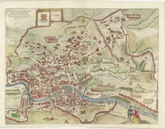
Rare 1572 Map of Ancient Rome with Monuments by Ligorio, Braun & Hogenberg
Located in Langweer, NL
Rare 1572 Map of Ancient Rome with Monuments by Ligorio, Braun & Hogenberg
This remarkable 16th-century map, *Urbis Romae Situs cum ils quae adhuc Conspiciuntur Veter. Monumet Rel...
Category
Antique 16th Century German Maps
Materials
Paper
$1,804 Sale Price
20% Off
View of Seravalle, Italy: A 16th Century Hand-colored Map by Braun & Hogenberg
By Franz Hogenberg
Located in Alamo, CA
This is an original 16th century copperplate originally hand-colored engraved map of View of Seravalle, Italy entitled "Seravallum Celeberrimum Marchiae Tarvisiniae in Agro Foro Juliensi Opp. - Seravalli, quam vides, Spectator, iconem, operi huic nostro suis sumptib. . . ." by Georg Braun & Franz Hogenberg, from their famous city atlas "Civitates Orbis Terrarum", published in Augsberg, Germany in 1575.
The map depicts a view of Seravalle, now Vittorio Veneto, in San Marino, Italy, north of Venice, in a topographically accurate bird's-eye view from the south. A water-filled moat is seen to the south of the city walls and farmland to the east. Two men are depicted standing on a hill in the lower right in conversation next to grain sacks and a grazing horse, while a younger man behind them to the right herds a mule carrying presumably pigs. A very colorful and ornate title cartouche is in the upper center and coat-of-arms are in the right and left upper corners. Serravalle lies in an idyllic setting in the foothills and surrounded by orchards. St Mary's Cathedral with its tall bell tower is prominent in the center of the town. The marketplace and town hall with a bell tower in the square are depicted. Houses and shops are around the main square. Serravalle's importance as an agricultural centre is emphasized by the figures in the foreground. In 1337 Serravalle was conquered by the Republic of Venice. In 1866 the town was united with neighbouring Ceneda to form the town of Vittorio Veneto.
The following is an English translation of an excerpt from the French description of the city on the back of the map: "Serravalle, a market town renowned for cloth, wine and grain, is in such a beautiful situation that the number of its inhabitants, attracted by the loveliness of the place, has grown so much at times that the wall encircling it has had to be enlarged for the third time. The city with the surrounding town once belonged to the Church in Ceneda as an imperial fief. It subsequently became the seat of the Da Camino family (a princely house that at that time was one of the five most noble in all Italy). Now the city is under the sway of the Venetians but is prudently governed by them. For they send only one city councillor with instructions to ensure that justice prevails and to collect duties. In all else, power lies in the hands of the noble families."
This is a translation of the Latin in the title cartouche on the front: "The picture of the town of Serravalle, which you see, viewer, has been contributed to our work entirely at his own expense by Minutius, son of Hieronymus Minutius, a noble gentleman and one renowned for the far-reaching competence of his jurisdiction. We saw him sojourning in Cologne, where he was on business for Gregory XIII; while our good wishes accompany him, we should also like to accompany him on his way with this remembrance, even though it might be against his will, so that even those who have not seen him may learn of his excellence. However, those who do not yet know him will also see his excellence if God the Almighthy does not summon erring souls too soon back to the eternal seat of the Blessed."
References: Van der Krogt 4, 4728, State 1; Taschen, Braun and Hogenberg, p.331; Fauser, #14960
This striking hand-colored city view is printed on laid, chain-linked paper with wide margins. The sheet measures 16" high by 21" wide. There is a central vertical fold as issued and French text on the verso, with Latin on the front. There is some discoloration in the upper and right margins which may represent some watercolor paint from the time of the original hand-coloring of the map. There is a small hole to the right of the upper portion of the vertical fold, which is only visible when held up to light and an area of reinforcement on the verso of the lower vertical fold. The map is otherwise in very good to excellent condition.
Braun and Hogenberg's 'The Civitates Orbis Terrarum' was the second atlas of maps ever published and the first atlas of cities and towns of the world. It is one of the most important books published in the 16th century. Most of the maps in the atlas were engraved by Franz Hogenberg and the text, with its descriptions of the history and additional factual information of the cities, was written by a team of writers and edited by Georg Braun. The work contained 546 bird-eye views and map views of cities and towns from all over the world. It gave graphic representation of the main features of the illustrated cities and towns, including the buildings and streets. Although the ordinary buildings are stylized, the principal buildings are reproduced from actual drawings created on location. The principal landmarks and streets can still be recognized today. In addition, the maps often include the heraldic arms of the city, the nature of the surrounding countryside, the important rivers, streams and harbors, even depicting stone bridges, wooden pontoons, flat-bottomed ferries, ships and working boats, wharves and jetties, as well as land-based activities, including horsemen, pedestrians, wagons, coaches, and palanquins. Small vignettes are often included which illustrate the trade, occupations and habits of the local inhabitants, such as agriculture, paper-making and textiles, as well as local forms of punishment, such as gibbets, wheels, floggings etc. Large figures dressed in their local costume are often presented out of proportion in the foreground. The aim of the authors was to give as much information as possible in a pleasing visual form. They succeeded in creating maps that were both informative and decorative works of art. The atlas is a wonderful glimpse of life in medieval Europe.
Georg Braun (1541-1622) was German Catholic...
Category
16th Century Old Masters Landscape Prints
Materials
Engraving

Antique Map of North Africa by Ortelius, c.1580
Located in Langweer, NL
Antique map titled 'Barbariae et Biledulgerid Nova Descriptio'. Original antique map of North Africa. The map covers the regions of Barbaria and Biledulgerid, essentially the territo...
Category
Antique 16th Century Belgian Maps
Materials
Paper
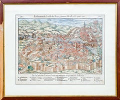
Antique Map of The City of Rome by Sebastian Münster, 1549
By Sebastian Münster
Located in New York, NY
Sebastian Münster (German, 1488-1552)
LA SITUATION DE LA VILLE DE ROME
Antique Map of Rome, 1549
Possibly printed in 1964
Print on paper
Publisher:...
Category
1960s Realist Figurative Prints
Materials
Woodcut
More Ways To Browse
Ota Masamitsu
Oyvind Fahlstrom On Sale
Pablo Picasso Signed Aquatint
Pablo Picasso The Kiss
Parc Monceau Harold Altman
Pegge Hopper Print
Peter Max 1972
Peter Max Angels Signed
Peter Max Liberty And Justice For All
Peter Max Seasons
Peter Max Smile
Peter Schmidt On Sale
Phoebe Cole
Picasso Arena
Picasso Bouquet Of Peace
Picasso Carnival
Picasso Don Quixote
Picasso Heliogravure