Items Similar to Scotia Regnum - Etching by Frederick de Wit - 1680ca
Want more images or videos?
Request additional images or videos from the seller
1 of 5
Frederick de WitScotia Regnum - Etching by Frederick de Wit - 1680ca 1680 ca
1680 ca
$1,194.67
£892.84
€1,000
CA$1,648.11
A$1,805.20
CHF 950.44
MX$21,544.40
NOK 12,112.45
SEK 11,072.60
DKK 7,622.14
About the Item
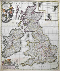
This double-page etching with contemporary coloring, entitled Scotia Regnum, was realized by the cartographer Frederick de Wit for the famous Atlas published in Amsterdam in ca. 1680.
The state of preservation is fair: central fold reinforced in antiquity on the reverse, cropped margins, slight defects, stains and browning of the paper.
Folio, measures ca. cm 51,5x59,8
Inscription on the reverse "Foglio 26 / Scozia"
Frederick de Wit was a cartographer and map-seller who was best known for his atlases and his Dutch town maps. His maps were known for their accuracy and detail, and contributed significantly to the documentation and understanding of the lands explored and discovered in the 17th century. His work had a considerable influence on the diffusion of geographical and cartographic knowledge of the time.
- Creator:Frederick de Wit (1630 - 1706, Dutch)
- Creation Year:1680 ca
- Dimensions:Height: 20.28 in (51.5 cm)Width: 23.55 in (59.8 cm)Depth: 0.04 in (1 mm)
- Medium:
- Movement & Style:
- Period:1680-1689
- Framing:Framing Options Available
- Condition:Insurance may be requested by customers as additional service, contact us for more information.
- Gallery Location:Roma, IT
- Reference Number:Seller: T-1549111stDibs: LU650316393632

Frederick de Wit
Frederick De Wit (1629-1706) was an engraver, cartographer and map dealer who ran a prominent and productive printing business in Amsterdam, founded in 1654 and initially called The Three Crabs and later The White Chart. He published his first atlas in 1662. In 1695 he purchased a large collection of the plates of the prestigious Blaeu publishing business. After his death in 1706, his wife Maria continued in the business for four years before selling it at the auction. A majority of the plates were purchased by Pieter Mortier. His thriving and growing business eventually became Covens & Mortier, one of the largest and most successful cartography and printing businesses of the eighteenth century.
About the Seller
4.9
Platinum Seller
Premium sellers with a 4.7+ rating and 24-hour response times
1stDibs seller since 2017
7,861 sales on 1stDibs
Typical response time: 1 hour
- ShippingRetrieving quote...Shipping from: Grasse, France
- Return Policy
More From This Seller
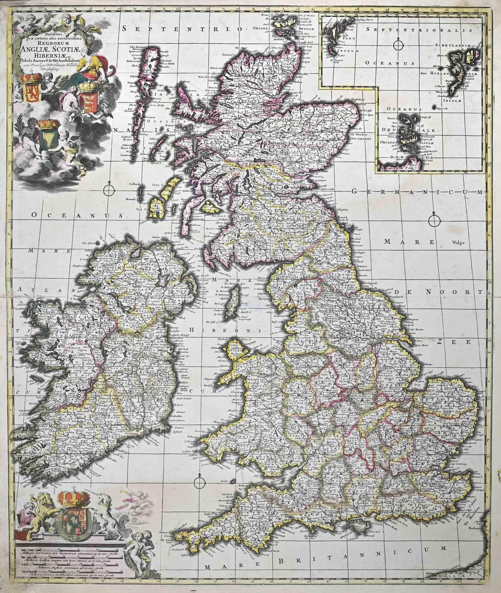
View AllNovissima Prae Caeteris Aliis... - Etching by Frederick de Wit - 1680ca
By Frederick de Wit
Located in Roma, IT
This double-page etching with contemporary coloring, entitled Novissima Prae Caeteris Aliis Accuratissima Regnorum Angliae, Scotiae, Hiberniae, was realized by the cartographer Frede...
Category
1680s Modern Figurative Prints
Materials
Etching
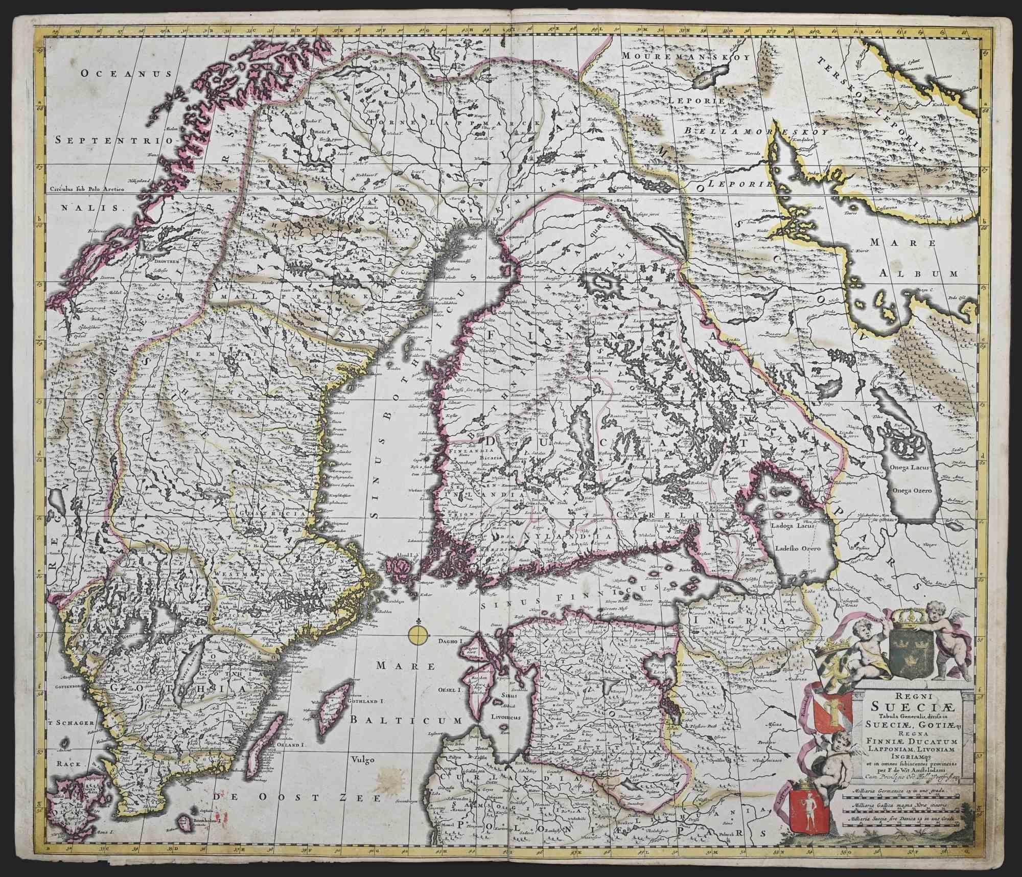
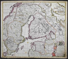
Regni Sueciae Tabula Generalis - Etching by Frederick de Wit - 1680ca
By Frederick de Wit
Located in Roma, IT
This double-page etching with contemporary coloring, entitled Regni Sueciae Tabula Generalis, was realized by the cartographer Frederick de Wit for the famous Atlas published in Amst...
Category
1680s Modern Figurative Prints
Materials
Etching
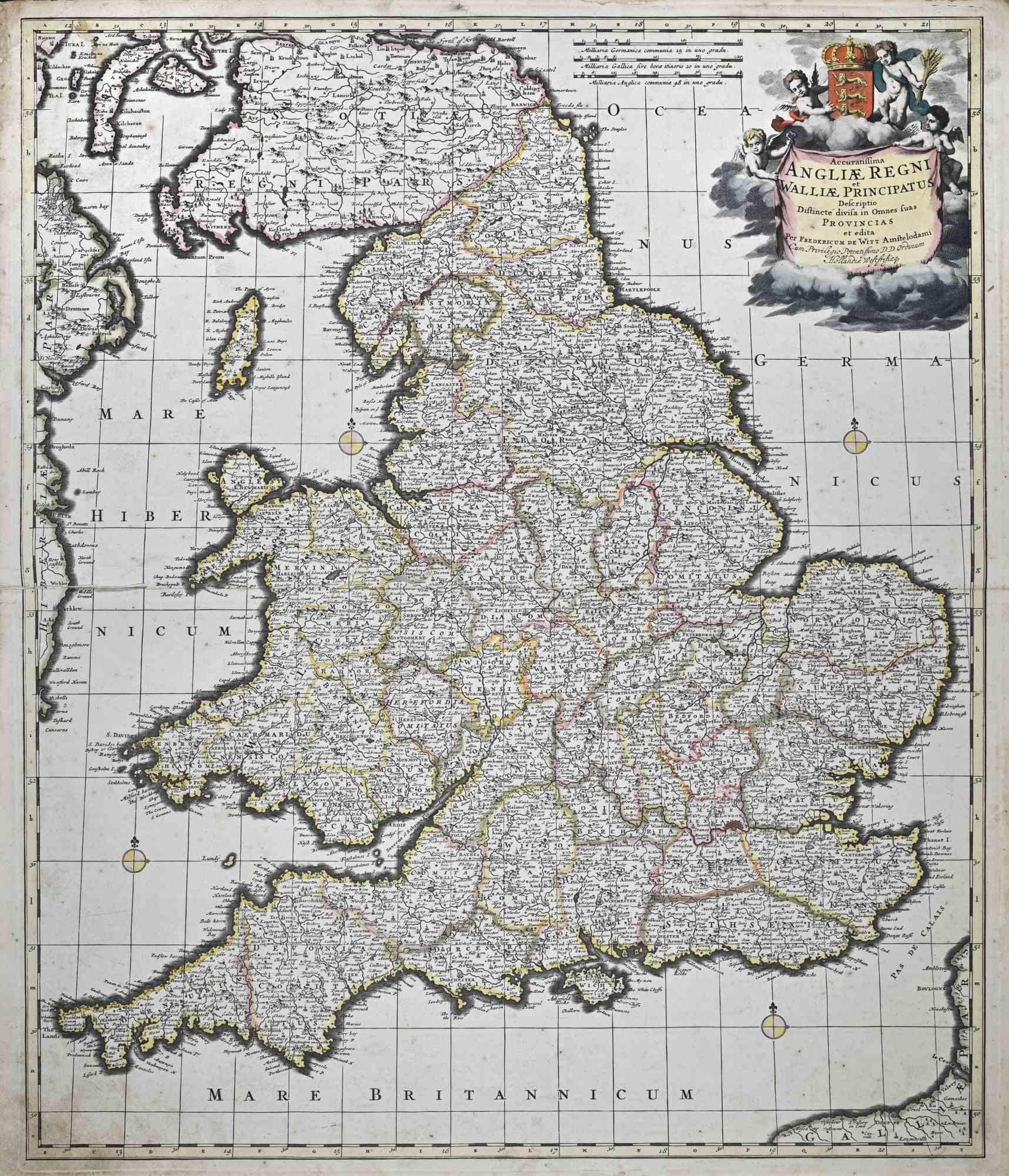
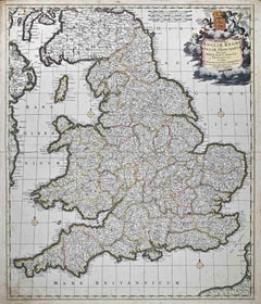
Accuratissima Angliae Regni et Walliae... - Etching by Frederick de Wit - 1680ca
By Frederick de Wit
Located in Roma, IT
This double-page etching with contemporary coloring, entitled Accuratissima Angliae Regni et Walliae Principatus, was realized by the cartographer Frederick de Wit for the famous Atl...
Category
1680s Modern Figurative Prints
Materials
Etching
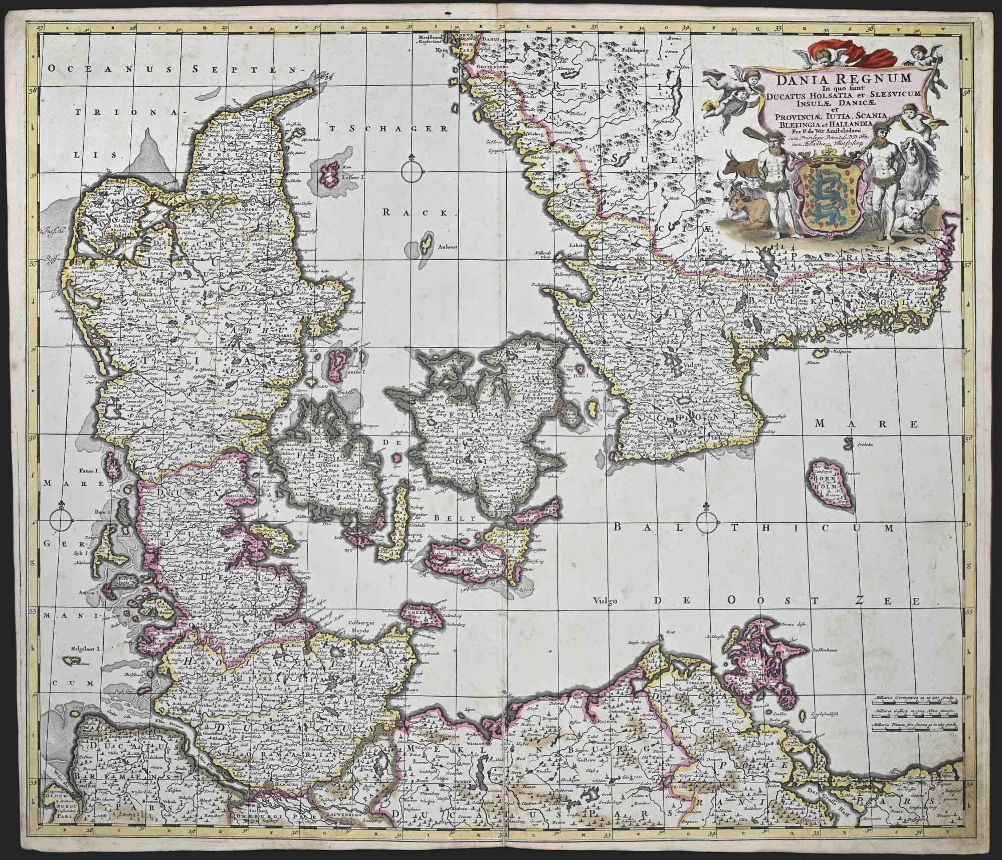
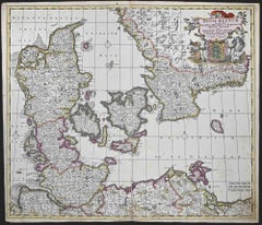
Dania Regnum - Etching by Frederick de Wit - 1680 ca
By Frederick de Wit
Located in Roma, IT
This double-page etching with contemporary coloring, entitled Dania Regnum [...], was realized by the cartographer Frederick de Wit for the famous Atlas published in Amsterdam in ca....
Category
1680s Modern Figurative Prints
Materials
Etching
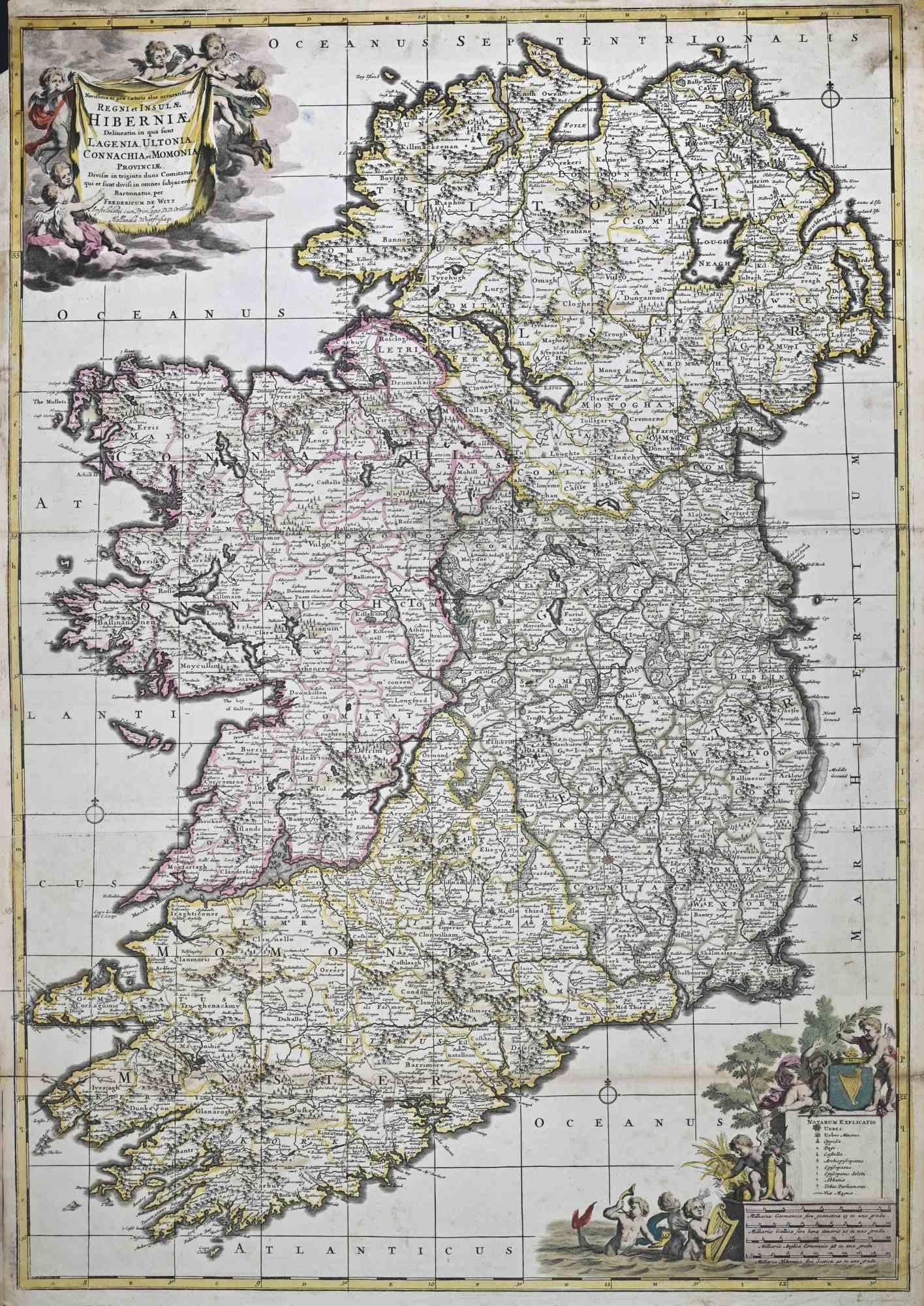
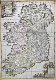
Novissima ac Prae Caeteris Alus Accurat.. - Etching by Frederick de Wit - 1680ca
By Frederick de Wit
Located in Roma, IT
This double-page etching with contemporary coloring, entitled Novissima ac Prae Caeteris Alus Accuratissima Regni et Insulae Hiberniae, was realized by the cartographer Frederick de ...
Category
1680s Modern Figurative Prints
Materials
Etching
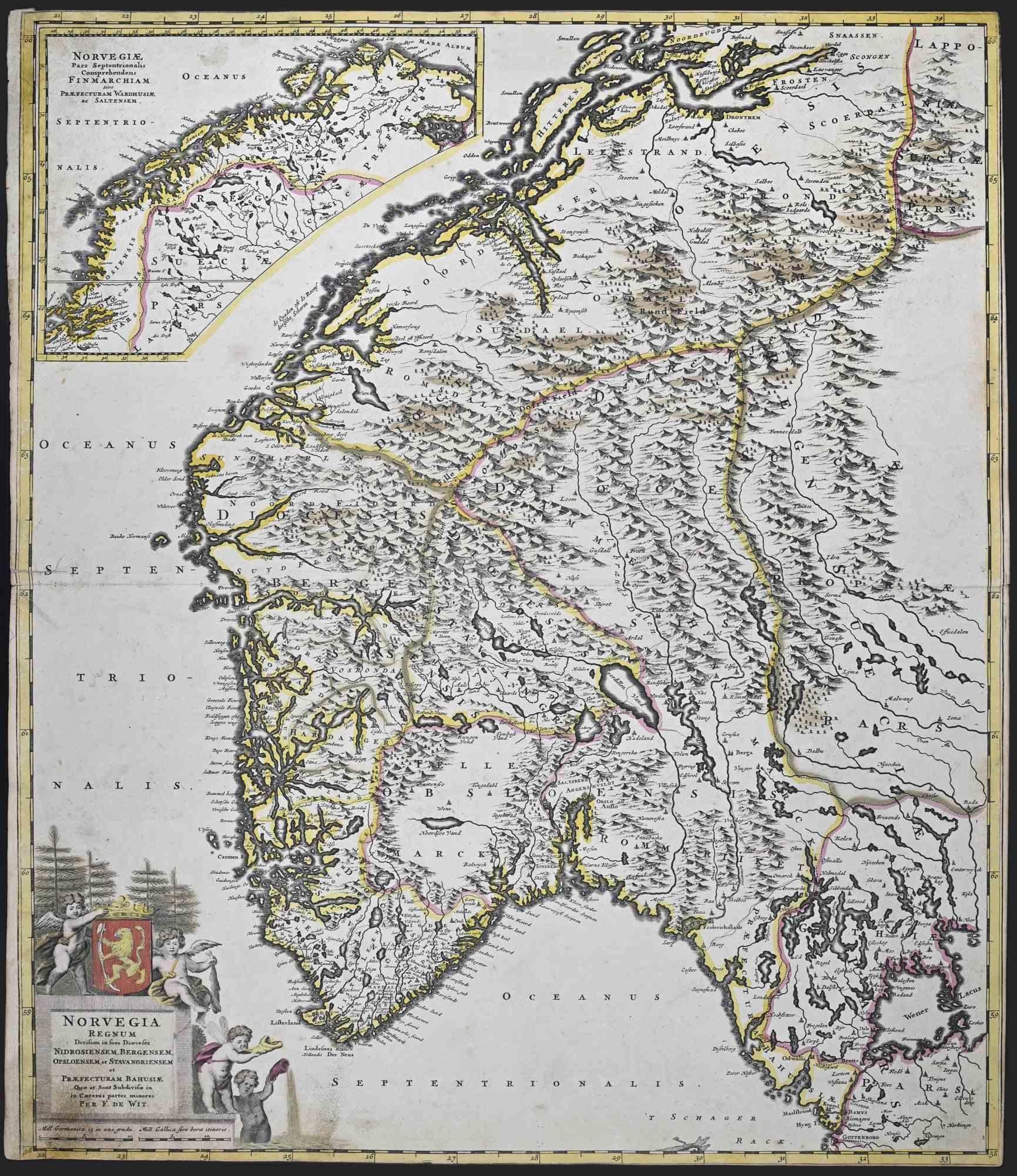
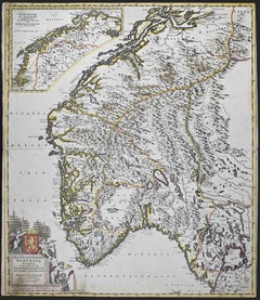
Norvegia Regnum - Etching by Frederick de Wit - 1680ca
By Frederick de Wit
Located in Roma, IT
This double-page etching with contemporary coloring, entitled Norvegia Regnum, was realized by the cartographer Frederick de Wit for the famous Atlas published in Amsterdam in ca. 16...
Category
1680s Modern Figurative Prints
Materials
Etching
You May Also Like
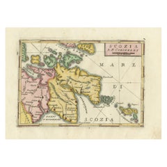
Scozia – Antique Map of Scotland by Coronelli, circa 1690
Located in Langweer, NL
Map of Scotland by Coronelli, c.1690 – “Scozia A.P. Coronelli”
This finely engraved and hand-colored map depicts Scotland, titled Scozia A.P. Coronelli, produced by the renowned Ven...
Category
Antique Late 17th Century Italian Prints
Materials
Paper
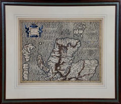
Northern Scotland: 17th Century Hand-colored Map by Mercator
By Gerard Mercator
Located in Alamo, CA
This is a framed hand-colored 17th century map of Northern Scotland by Gerard Mercator entitled "Scotiae pars Septentrionalis", published in Amsterdam in 1636. It is a highly detailed map of the northern part of Scotland, with the northwest Highlands and the cities Inverness and Aberdeen, as well as the Orkney Islands and the Hebrides. There is a decorative title cartouche in the upper left corner.
The map is presented in an antiqued brown wood...
Category
Mid-17th Century Other Art Style Landscape Prints
Materials
Engraving

Northern Scotland: 16th Century Hand-colored Map by Mercator
By Gerard Mercator
Located in Alamo, CA
This is a framed hand-colored 16th century map of Northern Scotland by Gerard Mercator entitled "Scotiae pars Septentrionalis", published in Amsterdam in 1636. It is a highly detailed map of the northern part of Scotland, with the northwest Highlands and the cities Inverness and Aberdeen, as well as the Orkney Islands and the Hebrides. There is a decorative title cartouche in the upper left corner.
The map is presented in an antiqued brown wood...
Category
16th Century Other Art Style Landscape Prints
Materials
Engraving
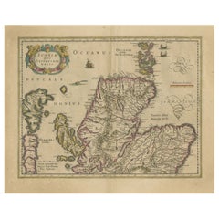
England and the British Isles: A Large 17th Century Hand-colored Map by de Wit
By Frederick de Wit
Located in Alamo, CA
This is a large hand-colored 17th century map of England and the British Isles by Frederick de Wit entitled "Accuratissima Angliæ Regni et Walliæ Principatus", published in Amsterdam in 1680. It is a highly detailed map of England, Scotland, the Scottish Isles...
Category
Late 17th Century Other Art Style Landscape Prints
Materials
Engraving

Original Antique Map of Scotland by Dower, circa 1835
Located in St Annes, Lancashire
Nice map of Scotland
Drawn and engraved by J.Dower
Published by Orr & Smith. C.1835
Unframed.
Free shipping
Category
Antique 1830s English Maps
Materials
Paper

Original Antique Map of the Northern Part of Scotland, circa 1640
Located in Langweer, NL
The antique map, titled 'Scotiae pars septentrionalis,' depicts the northern part of Scotland. Crafted by Hondius around 1640, this map is a historical treasure showcasing the geogra...
Category
Antique Mid-17th Century Maps
Materials
Paper
$841 Sale Price
20% Off