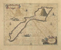
Items Similar to Barbarga - Etching by Johannes Janssonius - 1650s

Want more images or videos?
Request additional images or videos from the seller
1 of 6
Johannes JanssoniusBarbarga - Etching by Johannes Janssonius - 1650s1650s
1650s
$2,366.25
£1,797.68
€2,000
CA$3,324.95
A$3,651.45
CHF 1,879.63
MX$43,690.67
NOK 23,931.80
SEK 22,427.66
DKK 15,235.55
About the Item
Barbarga is an ancient map realized in 1650 by Johannes Janssonius (1588-1664).
Good conditions.
From Atlantis majoris quinta pars, Orbem maritimum [Novus Atlas, volume V: carte marittime]. Amsterdam: Janssonius, 1650. Technique is etching and they are hand watercolored, with coeval watercoloring.
First edition of this famous work by Janssonius also known as the "Waterwereld"; It is the first "maritime atlas (in the true sense of the word) printed in the Netherlands" (Koeman) and published as the fifth volume of the Atlas Novus.
- Creator:Johannes Janssonius (1588 - 1664, Dutch)
- Creation Year:1650s
- Dimensions:Height: 18.71 in (47.5 cm)Width: 23.23 in (59 cm)Depth: 0.04 in (1 mm)
- Medium:
- Movement & Style:
- Period:1650-1659
- Framing:Framing Options Available
- Condition:Insurance may be requested by customers as additional service, contact us for more information.a.
- Gallery Location:Roma, IT
- Reference Number:Seller: T-1411061stDibs: LU650312774092
About the Seller
4.9
Platinum Seller
Premium sellers with a 4.7+ rating and 24-hour response times
1stDibs seller since 2017
7,813 sales on 1stDibs
Typical response time: 1 hour
- ShippingRetrieving quote...Shipping from: Grasse, France
- Return Policy
More From This Seller
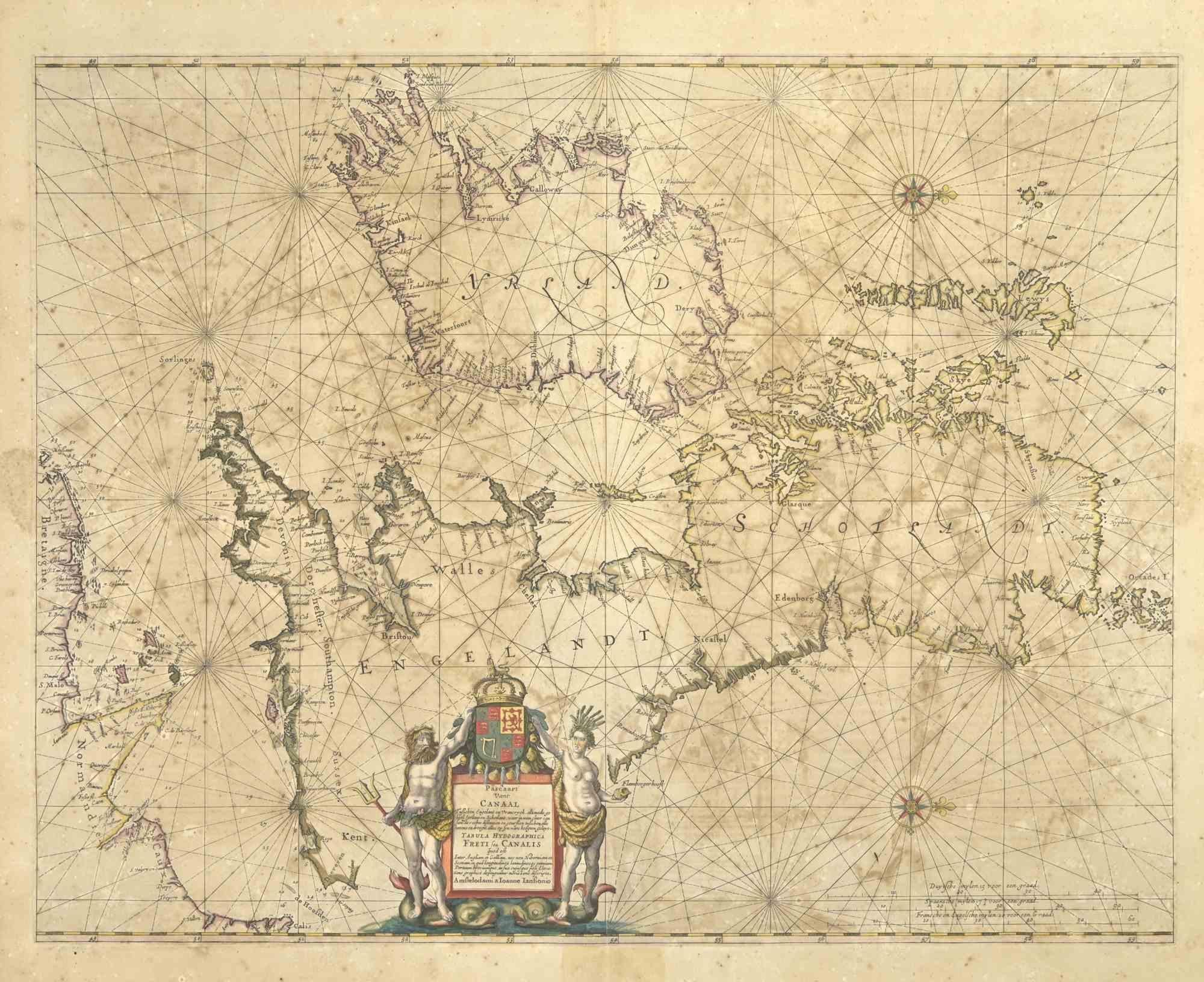
View AllFreti Canalis - Etching by Johannes Janssonius - 1650s
By Johannes Janssonius
Located in Roma, IT
Freti Canalis is an ancient map realized in 1650 by Johannes Janssonius (1588-1664).
Good conditions.
From Atlantis majoris quinta pars, Orbem maritimum [Novus Atlas, volume V: car...
Category
1650s Modern Figurative Prints
Materials
Etching
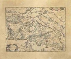
Nova Zemla - Etching by Johannes Janssonius - 1650s
By Johannes Janssonius
Located in Roma, IT
Nova Zemla is an ancient map realized in 1650 by Johannes Janssonius (1588-1664).
Good conditions.
From Atlantis majoris quinta pars, Orbem maritimum [Novus Atlas, volume V: carte ...
Category
1650s Modern Figurative Prints
Materials
Etching
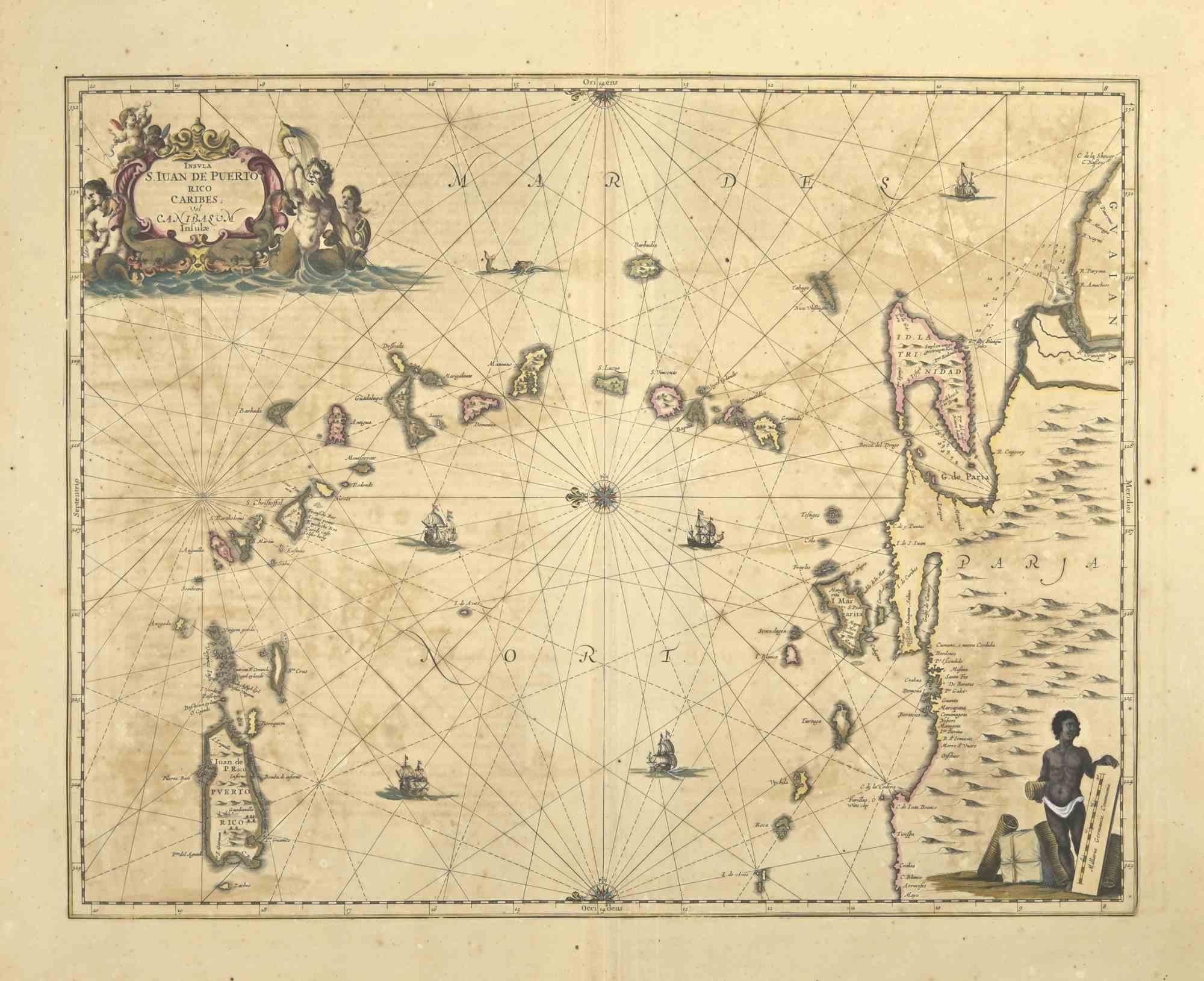
S.Juan de Puerto Rico - Etching by Johannes Janssonius - 1650s
By Johannes Janssonius
Located in Roma, IT
S.Juan de Puerto Rico is an ancient map realized in 1650 by Johannes Janssonius (1588-1664).
Good conditions.
From Atlantis majoris quinta pars, Orbem maritimum [Novus Atlas, volum...
Category
1650s Modern Figurative Prints
Materials
Etching
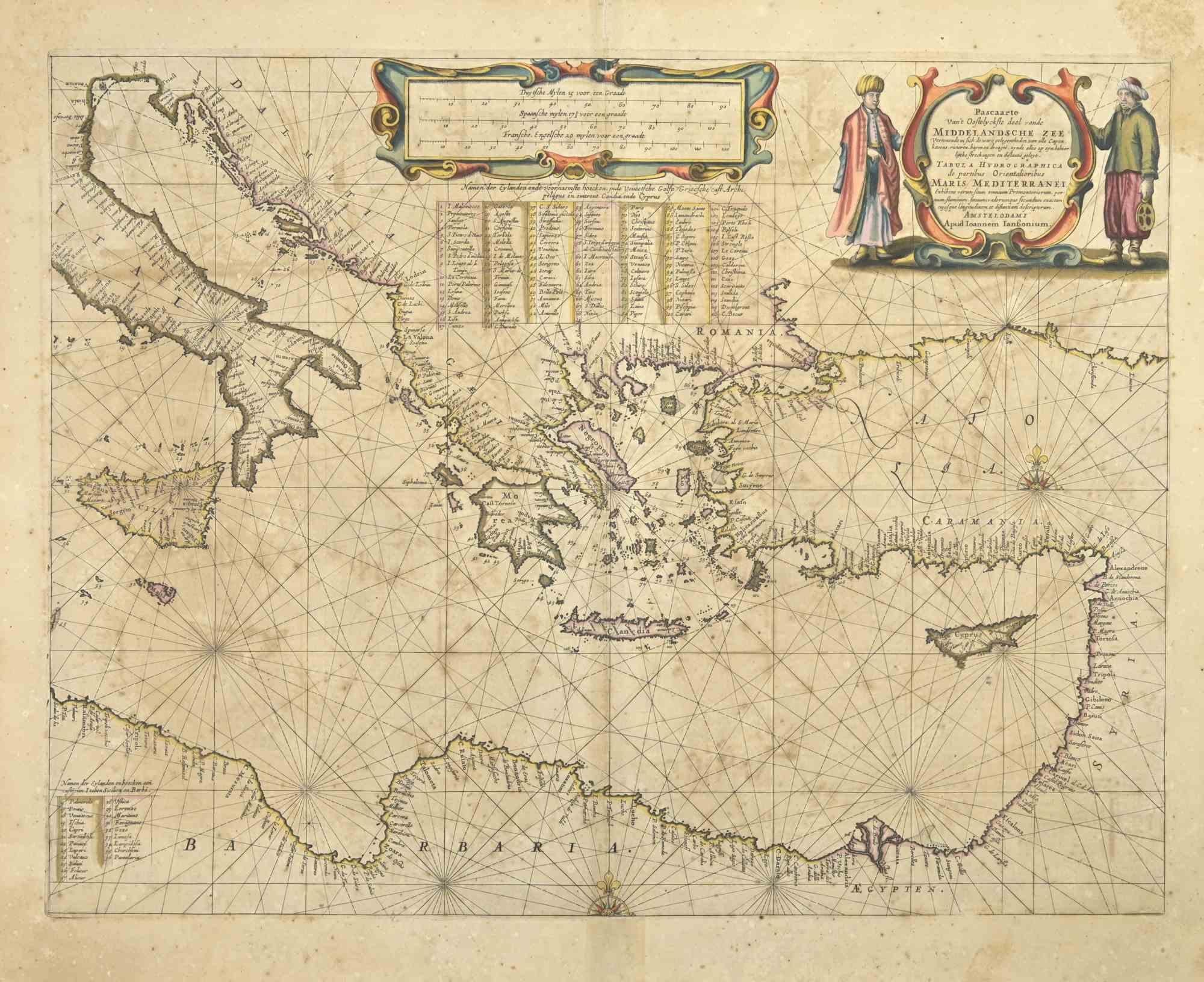
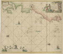
Maris Mediterranei - Etching by Johannes Janssonius - 1650s
By Johannes Janssonius
Located in Roma, IT
Maris Mediterranei is an ancient map realized in 1650 by Johannes Janssonius (1588-1664).
The Map is Hand-colored etching, with coeval watercoloring.
Good conditions with slight fo...
Category
1650s Modern Figurative Prints
Materials
Etching

Oceanus - Etching by Johannes Janssonius - 1650s
By Johannes Janssonius
Located in Roma, IT
Antique Map - Oceanus is an antique map realized in 1650 by Johannes Janssonius (1588-1664).
The Map is Hand-colored etching, with coeval watercoloring.
Good conditions with slight...
Category
1650s Modern Figurative Prints
Materials
Etching
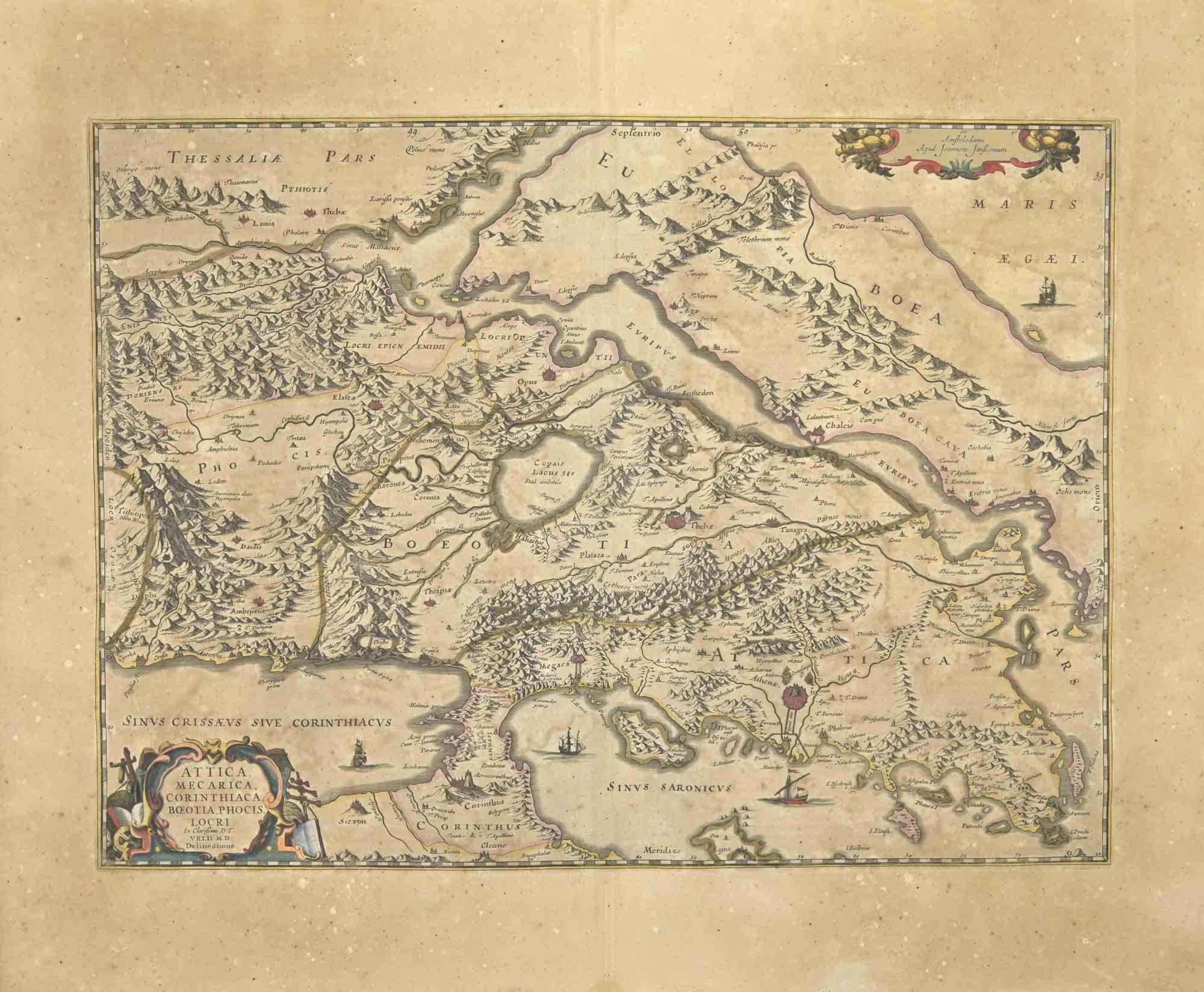
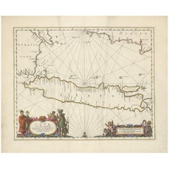
Attica - Etching by Johannes Janssonius - 1650s
By Johannes Janssonius
Located in Roma, IT
Antique Map - Attica is an antique map realized in 1650 by Johannes Janssonius (1588-1664).
The Map is Hand-colored etching, with coeval watercoloring.
Good conditions with slight ...
Category
1650s Modern Figurative Prints
Materials
Etching
You May Also Like
Indiarum Occidentalium Tractus Littorales cum Insulis Caribicis / Pascaert van W
By Louis Renard
Located in New York, NY
This early 18th-century engraved map was published by Louis Renard in Amsterdam. The image size is 19 x 22 " (48.3 x 55.9 cm) plus margins.
A beautifully engraved Dutch sea chart. Shown is the entire Caribbean basin including the eastern seaboard up to Cape Cod and includes Bermuda. Florida is shown with the classic flattened southeastern coast that was derived by Hessel Gerritz. Noted are the routes taken by the Spanish treasure...
Category
18th Century Other Art Style More Prints
Materials
Engraving

Antique Map of Nova Zembla by Janssonius, c.1650
Located in Langweer, NL
Antique map titled 'Nova Zemla, waygats fretum Nassovi cum et terra Samoiedum singula omnium emendatissime descripta'. This map depicts Nova Zembla and the northern continental coast...
Category
Antique 17th Century Maps
Materials
Paper

$375 Sale Price
20% Off
Rugen Island, Germany: An Early 17th Century Map by Mercator and Hondius
By Gerard Mercator
Located in Alamo, CA
This is an early 17th century map entitled "Nova Famigerabilis Insulae Ac Ducatus Rugiae Desciptio" (Map of Rugen Island, Germany) by Gerard Mercator and Henricus and Joducus Hondiu...
Category
Early 17th Century Old Masters Landscape Prints
Materials
Engraving

Original Antique Engraving of a Sea Chart of the Western Mediterranean, ca.1650
Located in Langweer, NL
Antique map titled 'Pascaerte van 't westlyckste deel vande Middelandsche-Zee (..)'.
Sea chart of the Western Mediterranean. The map extends from the Straits of Gibralter to Italy ...
Category
Antique 1650s Maps
Materials
Paper

1717 Johannes Van Keulen Sea Chart of the Eastern Atlantic - Amsterdam to Gambia
Located in Langweer, NL
1717 Johannes Van Keulen Sea Chart of the Eastern Atlantic - Amsterdam to Gambia
This 1717 sea chart by Johannes Van Keulen, titled "Nieuwe Paskaert vande ...
Category
Antique 1710s Dutch Maps
Materials
Paper
$1,996 Sale Price
25% Off
Antique Map of Java by Janssonius, circa 1650
Located in Langweer, NL
Antique map titled 'Insulae Iavae cum parte insularum Borneo Sumatrae, et circumjacentium insularum novissima delineatio'. Beautiful map of Java and parts of Bali, Borneo, Sumatra an...
Category
Antique Mid-17th Century Maps
Materials
Paper
More Ways To Browse
Ancient Maps
Stanislao Lepri
The Fables Chagall
Vintage Berry Picker
Abraham Bloemaert
African Woodcut
Against Apartheid
Ai Weiwei Signed
Albrecht Durer Woodcuts
Alexandra Exter
Allen Jones Lithograph
Antique Prints New Orleans
Botero Poster
Calder Clown
Calder Etching
Cavalier Picasso
Chagall Acrobats
Chagall Daphnis And Chloe