Items Similar to Map of Eastern Roman Empire -Vintage Offset Print - Early 20th Century


Want more images or videos?
Request additional images or videos from the seller
1 of 5
UnknownMap of Eastern Roman Empire -Vintage Offset Print - Early 20th CenturyEarly 20th Century
Early 20th Century
$239.55
£177.75
€200
CA$334.56
A$362.84
CHF 190.58
MX$4,407.33
NOK 2,384.79
SEK 2,245.41
DKK 1,523.65
About the Item
This map of Eastern Roman Empire is a vintage offset print realized in the early 20th Century.
The state of preservation of the artwork is aged with diffused foxing an small cutaways on margin. The middle line is repaired.
Sheet dimension : 47 x 60 cm.
Passepartout: 60 x 70 cm.
This artwork represents skillfully a detailed view of the Eastern Roman Empire through confident strokes.
- Creation Year:Early 20th Century
- Dimensions:Height: 14.18 in (36 cm)Width: 21.66 in (55 cm)Depth: 0.04 in (1 mm)
- Medium:
- Period:
- Framing:Framing Options Available
- Condition:Insurance may be requested by customers as additional service, contact us for more information.
- Gallery Location:Roma, IT
- Reference Number:Seller: M-1144401stDibs: LU65037519152
About the Seller
4.9
Platinum Seller
Premium sellers with a 4.7+ rating and 24-hour response times
1stDibs seller since 2017
7,733 sales on 1stDibs
Typical response time: 2 hours
- ShippingRetrieving quote...Shipping from: Roma, Italy
- Return Policy
Authenticity Guarantee
In the unlikely event there’s an issue with an item’s authenticity, contact us within 1 year for a full refund. DetailsMoney-Back Guarantee
If your item is not as described, is damaged in transit, or does not arrive, contact us within 7 days for a full refund. Details24-Hour Cancellation
You have a 24-hour grace period in which to reconsider your purchase, with no questions asked.Vetted Professional Sellers
Our world-class sellers must adhere to strict standards for service and quality, maintaining the integrity of our listings.Price-Match Guarantee
If you find that a seller listed the same item for a lower price elsewhere, we’ll match it.Trusted Global Delivery
Our best-in-class carrier network provides specialized shipping options worldwide, including custom delivery.More From This Seller
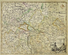
View AllMap of the War -Vesfaglia and Lower Saxony - Etching - 19th Century
Located in Roma, IT
Map of the War -Vestaglia and Lower Saxony is an etching realized during the 19th century.
Good condition.
Category
Early 19th Century Modern Figurative Prints
Materials
Etching

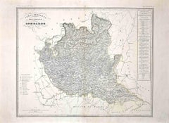
Map of Lombardy - Original Etching - 19th Century
Located in Roma, IT
The Map of Lombardy is an original etching realized by an anonymous artist.
Fair conditions, the folding line of the middle is repaired.
The artwork represents the map of Lombardo....
Category
19th Century Modern Figurative Prints
Materials
Etching
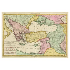
Map of Ancient Greece of Macedonia and... - Lithograph by Auguste Wahlen - 1844
Located in Roma, IT
Map of Ancient Greece of Macedonia and Thrace is a lithograph made by Auguste Wahlen in 1844.
Hand colored.
Good condition.
Bottom left is the original title "Carta della Grecia A...
Category
1840s Modern Figurative Prints
Materials
Lithograph

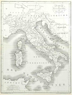
Map of Italy - Etching by Pierre François Tardieu - 1837
Located in Roma, IT
Map of Italy is an Etching realized in 1837.
Good conditions.
The artwork is realized in a well-balanced composition. the artwork and belongs to the suite suite "AtlasBatt" realize...
Category
1830s Modern Figurative Prints
Materials
Lithograph
Map of the War between Hungary and Prussia - Etching - 19th Century
Located in Roma, IT
Map of the War between Hungary and Prussia is an etching realized during the 19th century.
Good condition.
Category
Early 19th Century Modern Figurative Prints
Materials
Etching
$479 Sale Price
20% Off
Map of the War between Hungary and Prussia - Etching - 19th Century
Located in Roma, IT
Map of the War between Hungary and Prussia is an etching realized during the 19th century.
Good condition.
Category
Early 19th Century Modern Figurative Prints
Materials
Etching

You May Also Like
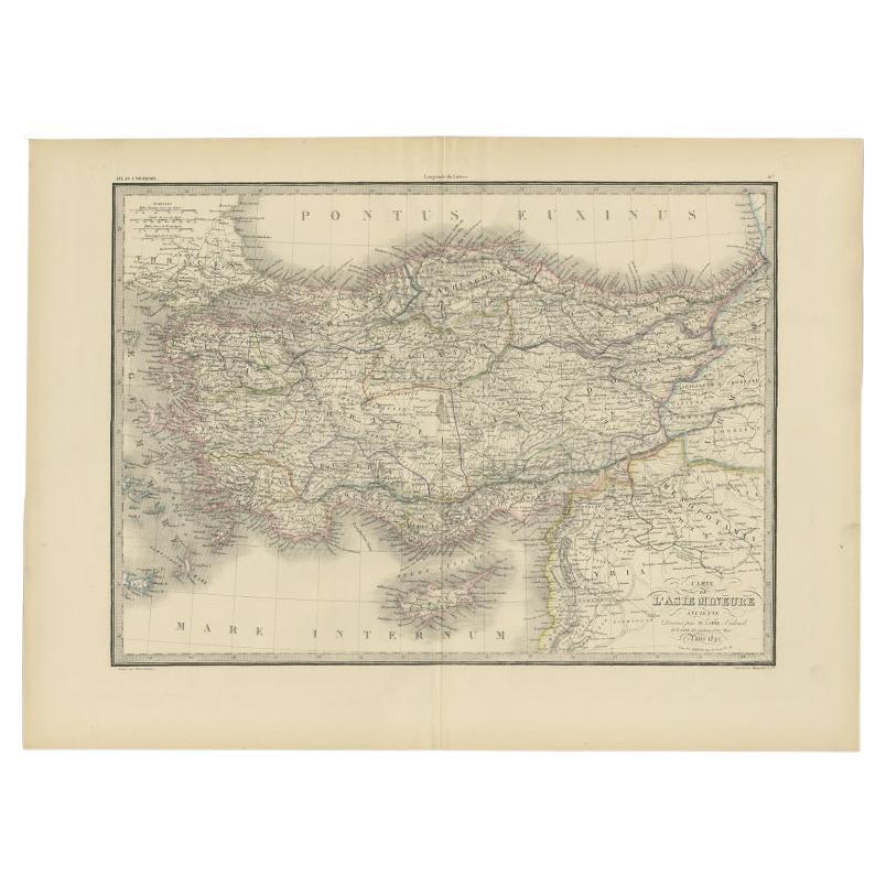
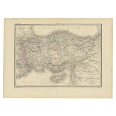
Antique Map of Asia Minor by Lapie, 1842
Located in Langweer, NL
Antique map titled 'Carte de l'Asie Mineure Ancienne (..)'. Map of Asia Minor, also called Anatolia or Turkish Anadolu. This map originates from 'Atlas univ...
Category
Antique 19th Century Maps
Materials
Paper
$373 Sale Price
20% Off
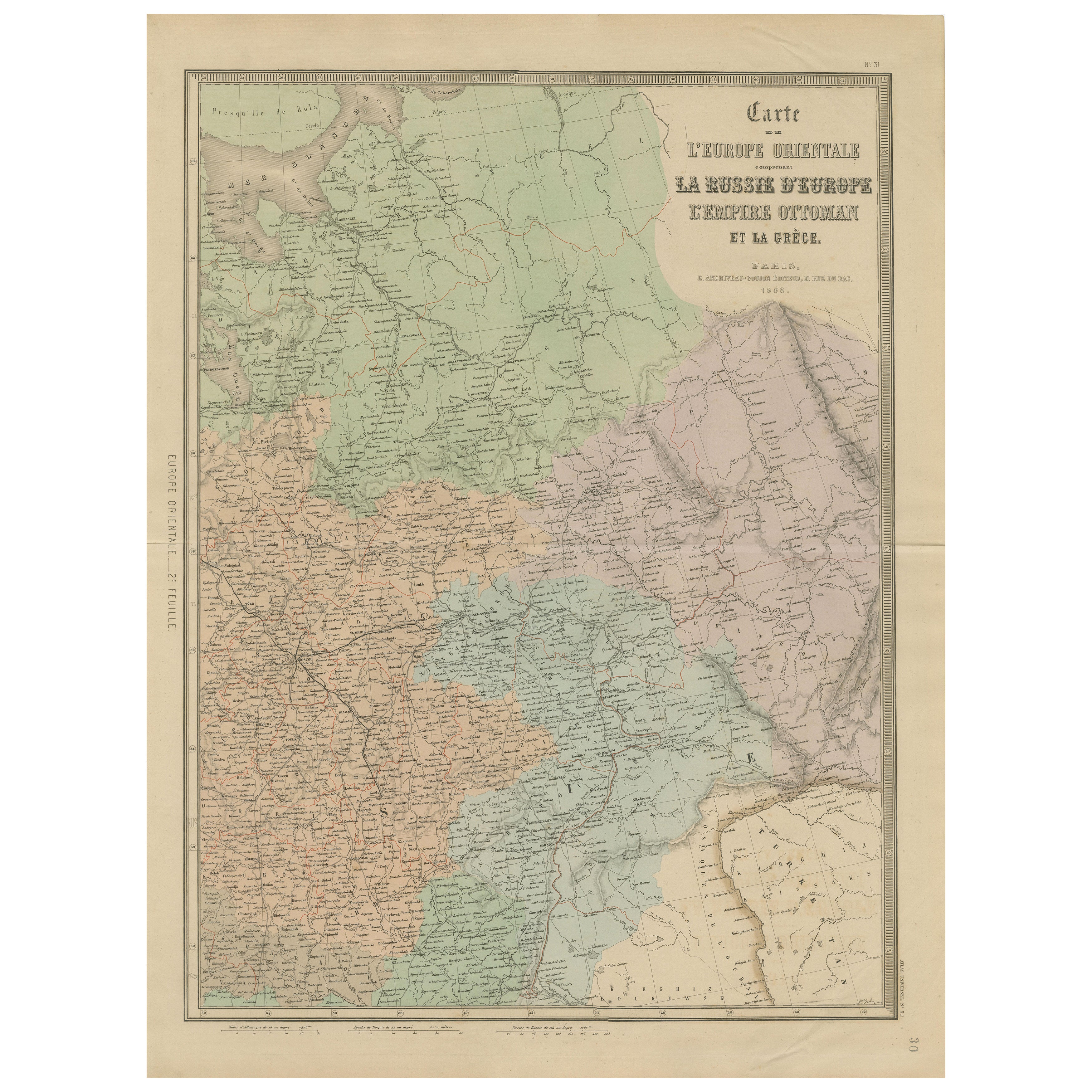
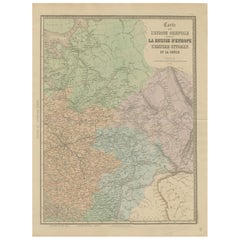
Antique Map of Eastern Europe – Russia, Ottoman Empire & Greece, 1868
Located in Langweer, NL
Antique Map of Eastern Europe – Russia, Ottoman Empire and Greece by Andriveau-Goujon, 1868
This detailed antique map titled “Carte de l’Europe Orientale, la Russie d’Europe, l’Empi...
Category
Antique Mid-19th Century French Maps
Materials
Paper
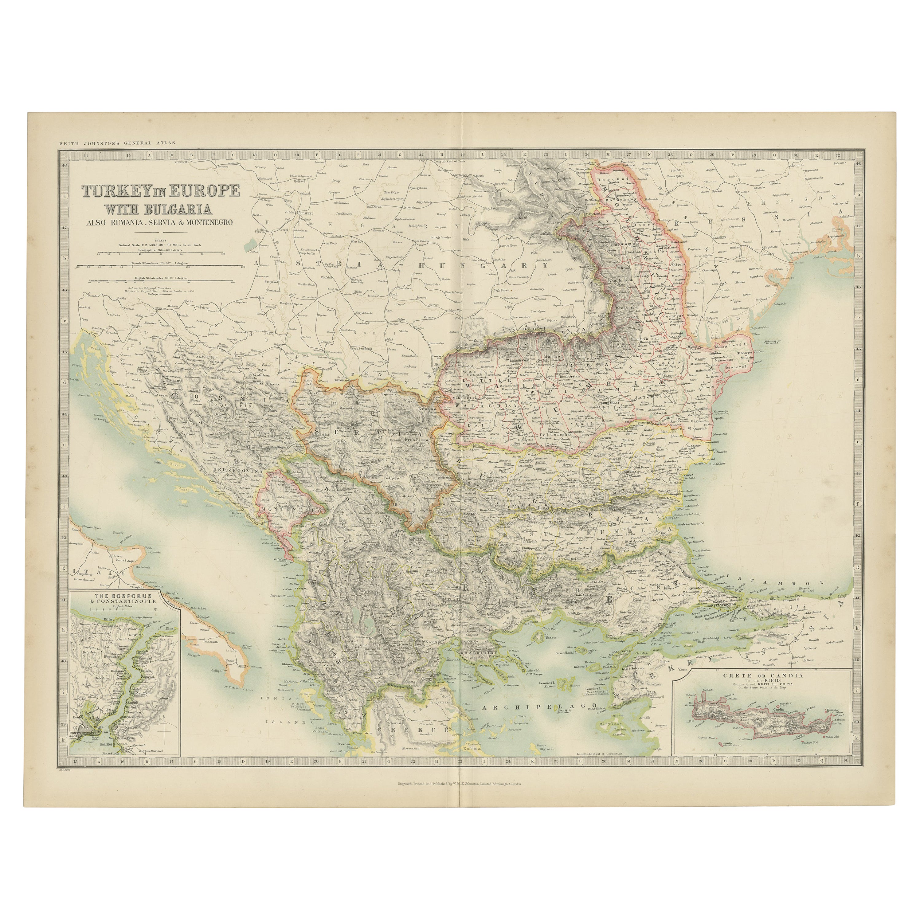
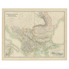
Antique Map of Turkey in Europe with Bulgaria by Johnston, 1909
Located in Langweer, NL
Antique map titled 'Turkey in Europe with Bulgaria'. Original antique map of Turkey in Europe with Bulgaria. With inset maps of The Bosporus & Constantinople, and Crete (or Candia). ...
Category
Early 20th Century American Maps
Materials
Paper
Antique Map of Turkey in Europe by Wyld, '1845'
Located in Langweer, NL
Antique map titled 'Turkey in Europe'. Original antique map of Turkey in Europe. This map originates from 'An Atlas of the World, Comprehending S...
Category
Antique Mid-19th Century Maps
Materials
Paper

$191 Sale Price
20% Off
Antique Map of Turkey and Greece by Petri, c.1873
Located in Langweer, NL
Antique map titled 'Europisch Turkije en Griekenland'. Old map depicting Turkey in Europe and Greece. This map originates from 'School-Atlas van alle Deelen der Aarde'.
Artists and...
Category
Antique 19th Century Maps
Materials
Paper

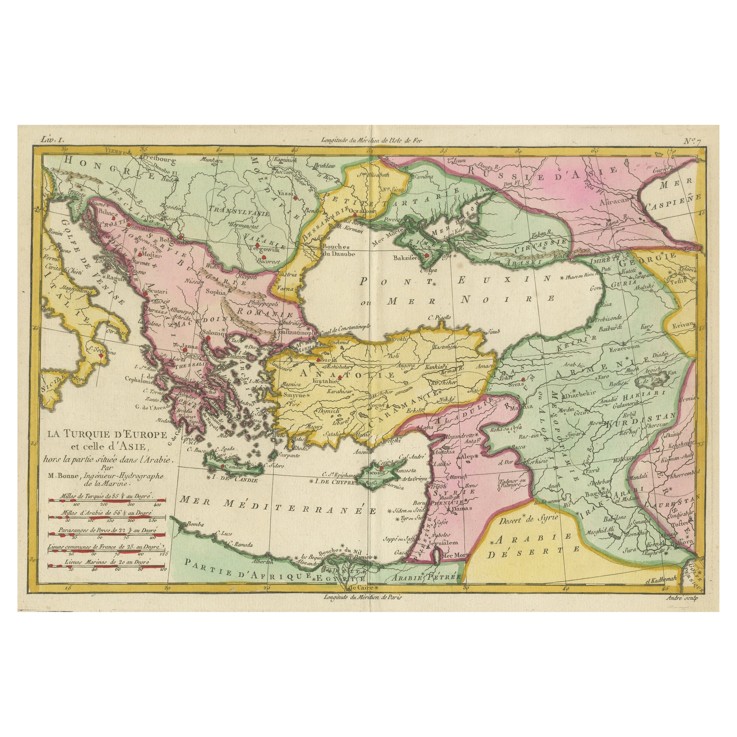
Antique Map of the Eastern Mediterranean and the Balkans
Located in Langweer, NL
Antique map titled 'La Turquie d'Europe et celle d'Asie'. Attractive double page map of the Eastern Mediterranean and the Balkans by R. Bonne. Originates from 'Atlas de Toutes les Pa...
Category
Antique Late 18th Century Maps
Materials
Paper
$517 Sale Price
20% Off
More Ways To Browse
Antique Roman Map
Giovanni Battista Piranesi Vaso Di Marmo Antico Che Si Vede Nel Museo Capitolino Etching 1778
Grace Albee
Gustave Adolph Hoffman On Sale
H Hargrove
H Otsuka
Helen Hyde On Sale
Henri Cartier Bresson Poster
Henri Matisse Plate 4
Henrik Simonsen
Henry Casselli
Henry Moore Elephant
Henry Moore Sheep
Henry Wilkinson Etching
Herbert Matter Vintage Airline Poster
Herman Wessel
Hobbs Modern
Hodaya Louis