Items Similar to A Group of Four 18th Century Engravings from Captain Cook's 3rd Voyage Journal


Want more images or videos?
Request additional images or videos from the seller
1 of 24
John WebberA Group of Four 18th Century Engravings from Captain Cook's 3rd Voyage Journal1784
1784
About the Item
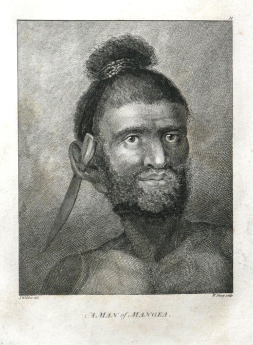
A grouping of four framed engravings from the atlas of the official British Admirality sanctioned journal of Captain Cook's 3rd Voyage entitled "A Voyage to the Pacific Ocean Undertaken by the Command of His Majesty, for Making Discoveries in the Northern Hemisphere", published upon completion of the voyage in London in 1784 by Strahan & Cadell. These engravings were made from drawings by John Webber (1752-1793), who was the artist on Captain James Cook's 3rd and final voyage of discovery. The set of engravings includes: "A Canoe of the Sandwich Islands, the Rowers Masked", Plate 65 in the atlas; "A Dance in Otaheite" (Tahiti), Plate 28; "King of the Friendly Islands" (Tonga), plate 20; "Inside of a House in Nootka Sound" (Canada), plate 42.
These engravings are professionally framed in Koa wood, the same wood as was used to make the canoes of the ancient Hawaiians. Koa wood is legendary in Hawaii. Not only is this amazing wood native to Hawaii, but it is known for the deep rich colors and varied grain pattern. Koa has an honored heritage in Hawaii and is highly revered and sacred. The word “koa” means “warrior” in Hawaiian. The warriors of King Kamehameha the Great, created canoes and weapons from a wood plentiful on the Big Island of Hawaii. This wood became synonymous with the warriors themselves, and it became known as koa.
These four engravings would make a wonderful grouping for a display of 2, 3 or 4 prints. They may be purchased separately or in groups on 1stDibs. Their listing Reference #'s are: LU117324682432, LU117324682022, LU117324684052 and LU117324684062. A discount is available for a grouping depending on the number of items included.
Hawaii was discovered by Captain Cook (1728-1779) during this voyage. Hawaii was originally called The Sandwich Islands in honor of The Earl of Sandwich who, as head of the British Admiralty, authorized the funds necessary to finance the voyage. Captain Cook was killed by natives in Kealakekua Bay on the big island of Hawaii in 1779. His ships the Resolution and Discovery then returned to England. Other notables who were part of this expedition included Captain William Bligh, Cook's sailing master, who would later go down in history as captain of the mutinous crew of the Bounty and George Vancouver who would later explore and chart North America's northwestern Pacific Coast regions, including the coasts of Alaska, Washington, and Oregon, as well as the province of British Columbia in Canada. Vancouver Island and the city of Vancouver, British Columbia are named for him, as is Vancouver, Washington.
The prints are in excellent condition.
- Creator:John Webber (1751 - 1793, British)
- Creation Year:1784
- Dimensions:Height: 20.75 in (52.71 cm)Width: 26.75 in (67.95 cm)Depth: 0.88 in (2.24 cm)
- Medium:
- Period:1780-1789
- Condition:Scattered mild foxing.
- Gallery Location:Alamo, CA
- Reference Number:Seller: #'s: 3853, 3854, 3855 and 38561stDibs: LU117325486982
John Webber
John Webber (1751-1793) was recommended to the Admiralty for appointment as artist for the Captain Cook's 3rd voyage by the Swedish botanist Daniel Carlsson Solander (1733-1782) who had accompanied Cook on his first voyage. Just 24 years old when he joined the Captain Cook’s ship the Resolution at Plymouth one week prior to departure, Webber's skill in both portraiture and landscape resulted in a visual record of Cook's third voyage that is unsurpassed in the annals of 18th century exploration.
About the Seller
5.0
Platinum Seller
Premium sellers with a 4.7+ rating and 24-hour response times
Established in 2011
1stDibs seller since 2019
281 sales on 1stDibs
Typical response time: 1 hour
- ShippingRetrieving quote...Shipping from: Alamo, CA
- Return Policy
Authenticity Guarantee
In the unlikely event there’s an issue with an item’s authenticity, contact us within 1 year for a full refund. DetailsMoney-Back Guarantee
If your item is not as described, is damaged in transit, or does not arrive, contact us within 7 days for a full refund. Details24-Hour Cancellation
You have a 24-hour grace period in which to reconsider your purchase, with no questions asked.Vetted Professional Sellers
Our world-class sellers must adhere to strict standards for service and quality, maintaining the integrity of our listings.Price-Match Guarantee
If you find that a seller listed the same item for a lower price elsewhere, we’ll match it.Trusted Global Delivery
Our best-in-class carrier network provides specialized shipping options worldwide, including custom delivery.More From This Seller
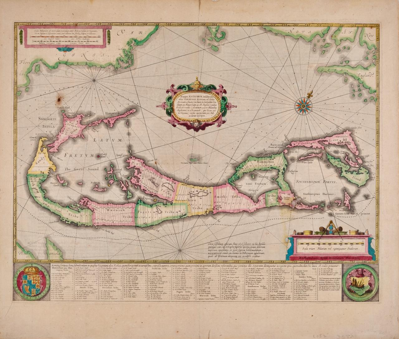
View AllBermuda: An Early 17th Century Hand-colored Map by Henricus Hondius
By Henricus Hondius
Located in Alamo, CA
This attractive and interesting map of Bermuda by Henricus Hondius in 1633 is entitled "Mappa Aestivarum Insularum, Alias Barmudas". It is based on a ...
Category
Early 17th Century Old Masters Landscape Prints
Materials
Engraving

Map of the World: An Original 18th Century Hand-colored Map by E. Bowen
Located in Alamo, CA
This is an original 18th century hand-colored map entitled "A New & Correct Chart of All The Known World Laid down according to Mercator's Projection" by Emanuel Bowen. It was published in 1744 in London in John Harris's "Navigantium atque Itinerantium Bibliotheca" or "A Complete Collection of Voyages and Travels". This highly detailed and colorful map depicts the world. as it was known in the mid 18th century. A majority of the northern and central portions of Canada and America are left blank due to the purity of knowledge at the time this map was published.
The map is embellished with four Compass Roses in the lower left, lower center, lower right and center, along with many rhumb lines. There a is a decorative title cartouche in the upper left. This colorful, attractive, historical and interesting 1744 map presents the entire world on Mercator's projection as it was understood in the middle part of the 18th century, before the landmark explorations of Captain’s Cook, Vancouver, Wilkes and others. It is an example of a nautical chart, a type of map that was designed specifically for use by mariners. The map is centered on the equator and includes both the Eastern and Western Hemispheres. The continents of North America, South America, Europe, Africa, and Asia are depicted, as well as various islands in the Atlantic, Pacific, and Indian Oceans. The map is laid out according to the Mercator projection, a type of cylindrical map projection that was developed in the 16th century by Flemish cartographer Gerardus Mercator. This projection has the advantage of preserving angles and shapes, making it useful for navigation. The map presents a paucity of inland detail, particularly for the Americas, but major cities, geographical landmarks, and regions are included. Ocean currents and Tradewinds are identified, as well as the magnetic declination lines or magnetic variance, which refers to the difference between true north and compass north. The continents are color coded, enhancing the beauty of this map. The three compass roses indicate the directions of the cardinal points.
The depiction of the western coast of America, the Pacific and Australia are interesting. There was very little exploration of Australia between the navigations of William Damper in 1699 and Tobias Furneaux in 1773. Most of the maps detail relies on the 17th century Dutch expeditions to Australia's western coast, by Abel Tasman and William Janszoon. Van Diemen's Land (Tasmania) and New Guinea appear connected to the Australian continent. New Zealand appears as a single landmass. North of New Zealand there is a landmass labelled 'Ter d' St. Esprit' which probably represents the New Hebrides Islands. This map precedes the accurate exploration of the South Pacific and east coast of Australia by Captain James Cook later in the 18th century. The map includes ‘Drakes' Port,' the site where Sir Francis Drake supposedly landed in 1579 during his 1579 circumnavigation of the globe. Here he claimed territory for England, restocked, and repaired his vessels. Drake named the region New Albion. The exact location of Drake's Port is a cartographic mystery. Drake's Harbor is believed to be in the region of San Francisco Bay, Bodega Bay, San Pablo Bay...
Category
Mid-18th Century Old Masters Landscape Prints
Materials
Engraving

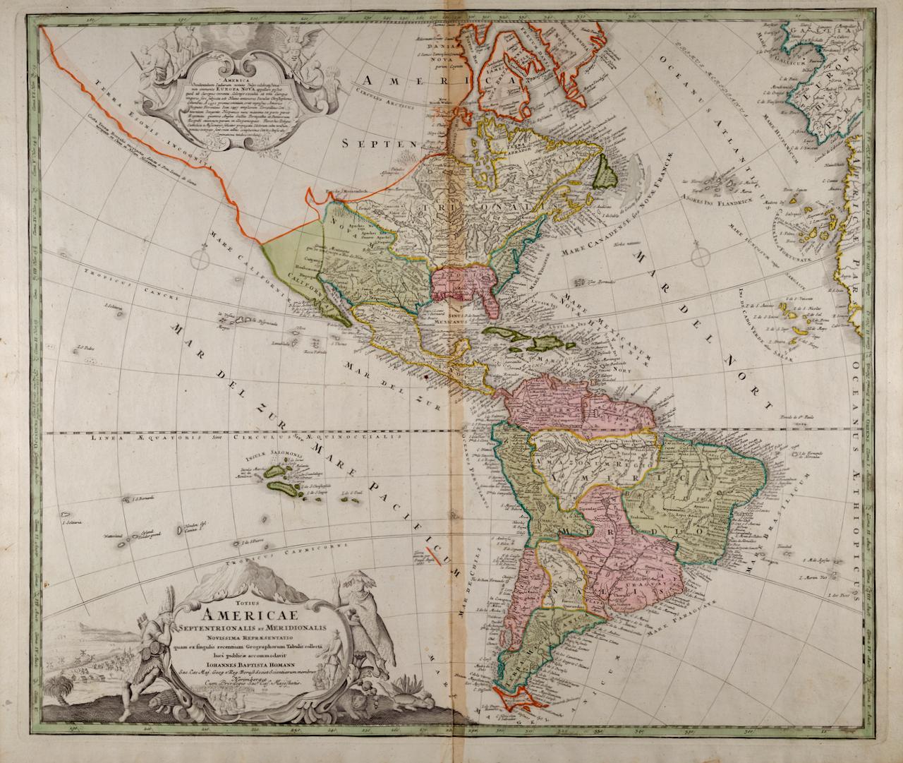
North and South America: An 18th Century Hand-colored Map by Johann Homann
By Johann Baptist Homann
Located in Alamo, CA
This early 18th century hand-colored copperplate map of North and South America entitled "Totius Americae Septentrionalis Et Meridionalis Novissima Repraesentatio" was created by Johann Baptist Homann and published in Nuremberg, Germany, between 1710 and 1731. The map details cities, forts, mountains, forests and lakes, as well as districts. There is a decorative cartouche in the lower left which depicts a volcano, scenes representing the people in their native costumes, as well as animals and plants of the Americas. A village is seen in the background on the left. A second smaller decorative cartouche in the upper right includes text and a series of allegorical figures. A large portion if the north central and western portions of North America is left without detail, because the region was largely unexplored at the time this map was created. The map also shows "Terra Esonis Incognita", representing a mythical continuous land bridge from North America to Asia, a northwest passage. The map preceded the French and...
Category
Early 18th Century Old Masters Landscape Prints
Materials
Engraving

Mediterranean and Adriatic Seas: Original 18th Century Hand-colored Map by Bowen
Located in Alamo, CA
This is an original 18th century hand-colored map entitled "An Accurate Chart of The Mediterranean and Adriatic Sea's; with the Archipelago & Part of the Black Sea. Exhibiting all th...
Category
Mid-18th Century Old Masters Landscape Prints
Materials
Engraving

Siberia as Explored by Behring: Original 18th Century Hand-colored Map by Bowen
Located in Alamo, CA
This is an original 18th century hand-colored map entitled "An Exact Chart of all the Countries through which Capt. Behring Travelled from Tobolski, Capital of Siberia to the Country...
Category
Mid-18th Century Old Masters Landscape Prints
Materials
Engraving

Europa Regnorum Provinciarum: 18th Century Hand-colored Map of Europe by Lotter
By Tobias Conrad Lotter
Located in Alamo, CA
This is an 18th century hand-colored copperplate engraved map entitled "Europa Regnorum Provinciarum Regionum" created by the German cartographer Tobias Conrad Lotter. It was publish...
Category
Mid-18th Century Landscape Prints
Materials
Engraving

You May Also Like
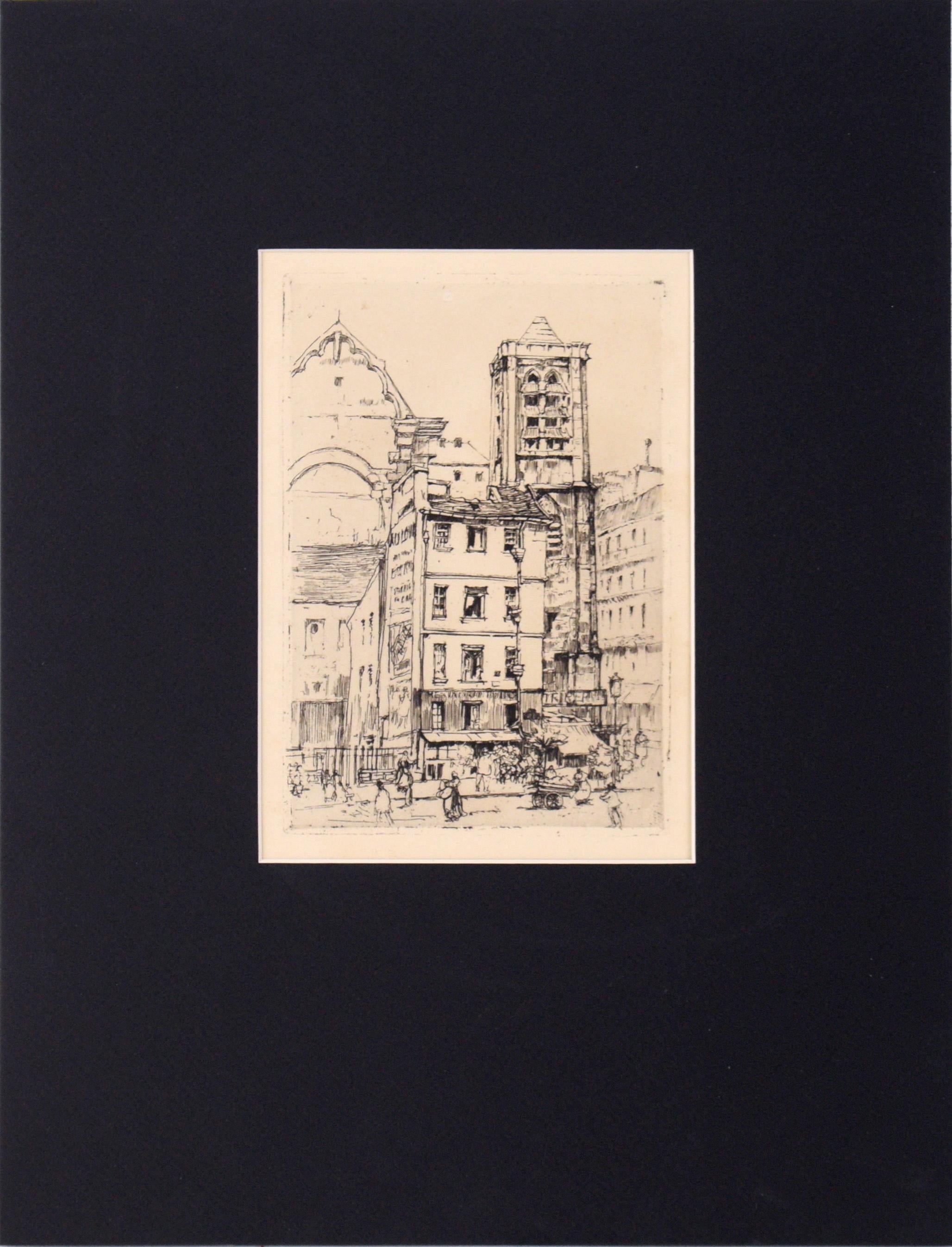
"St. Nicolas du Chardonnet" Etching in Ink on Paper
Located in Soquel, CA
"St. Nicolas du Chardonnet" Etching in Ink on Paper
Delicate and detailed etching by Katherine Kimball (American, 1866-1949). The Catholic church of St. Nicolas du Chardonnet is shown nestled in the streets of Paris. With clever use of line weight and clarity, the building is highlighted and cleanly stands out against the background and surroundings.
Stamp with coat of arms on verso.
Artist's info written on verso.
Presented in a new black mat with foamcore backing.
Mat size: 16"H x 12"W
Paper size: 10.75"H x 6.75"W
Katherine Kimball (American, 1866-1949) was born in Fitzwilliam, New Hampshire. She studied at the National Academy of Design in New York and exhibited in the San Francisco Panama-Pacific Exhibition of 1915. Listed in “Who Was Who in American Art, 1564-1975”; “North American Women Artists...
Category
1910s American Impressionist Landscape Prints
Materials
Paper, Ink, Drypoint
$460 Sale Price
20% Off
Landscape - Engraving after Rembrandt - 19th Century
By Charles Amand Durand
Located in Roma, IT
Landscape is an engraving on ivory-colored paper realized by Charles Amand Durand (1831-1905) after an etching by Rembrandt. This wonderful piece of art belongs to a late edition of ...
Category
19th Century Old Masters Figurative Prints
Materials
Engraving
"Coastal Ti Tree" Gums NSW Drypoint Etching in Ink on Paper No. 30/100
Located in Soquel, CA
"Coastal Ti Tree" Drypoint Etching in Ink on Paper No. 30/100
Detailed etching attributed to Ernest Edwin Abbot (British, 1888-1973). Several trees grow along the coast at the edge of the water at Ti Tree, Australia. In the far distance, a mountain range can be seen on the opposite shore.
Titled and numbered "Coastal Ti Tree 30-100" in the left corner.
Signed "G. Cope" in the right corner.
Presented in a new black mat with foamcore backing.
Mat size: 11"H x 14"W
Paper size: 5.5"H x 10.25"W
According to The Centre for Australian Art: Prints + Printmaking, Abbot often produced work under the pseudonym "G. Cope"
Ernest Edwin Abbott was born in 1889 and grew up in Bideford United Kingdom, With his younger siblings Violet, Reginald, Olive and his parents Charles and Sarah Abbott, His Farther worked as a upholsterer.
Abbott decided in 1911 to migrate to Western Australia on the ship Tainui, Settled in Western Australia he then married his wife Florence Radcliffe Olde in 1913 whom also came to Australia in 1912 from Bideford. They had two sons, Reginald Douglas Abbott and Kenneth John Abbott. They moved to South Australia where he taught art at Stott’s for four years. Later in 1920 the family moved to the suburb of Kew in Melbourne Victoria, where he took a studio in Oxford Chambers at 475 Bourke Street. He also built a studio later at his home in Black Rock. In about 1920 or 1930 he took up dry-point etching, and gave up his city studio to concentrate on printmaking at his home. Abbott made his own engraving tools...
Category
Early 20th Century Naturalistic Landscape Prints
Materials
Paper, Ink, Drypoint
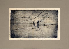
Two Figures on the Shore - Minimalist Landscape Drypoint Etching in Ink on Paper
By Doris Warner
Located in Soquel, CA
Two Figures on the Shore - Minimalist Landscape Drypoint Etching in Ink on Paper
Minimalist landscape with two figures walking along the shore by Doris Ann Warner (American, 1925-201...
Category
1980s Minimalist Landscape Prints
Materials
Paper, Ink, Drypoint
$460 Sale Price
20% Off
Palm Springs Courtyard with Fountain - Drypoint Etching on Paper
Located in Soquel, CA
Palm Springs Courtyard with Fountain - Drypoint Etching on Paper
Stately drypoint etching of the courtyard of a Palm Springs house by Leland "Lee" Fuller (American, 1899-1962). The focus of this piece is the courtyard of a house with a fountain. Behind the garden and fountain, there is a section of the house with an arched doorway and tile roof. This was likely a house that Fuller designed. From the Robert Azensky Fine Art Mary Pickford...
Category
1920s American Impressionist Landscape Prints
Materials
Paper, Ink, Drypoint

$680 Sale Price
20% Off
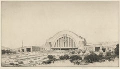
Cincinnati Union Terminal, Perspective From East
By Louis Conrad Rosenberg
Located in Fairlawn, OH
Cincinnati Union Terminal, Perspective From East
Drypoint, 1930-1931
Signed in pencil lower right (see photo)
Initialed and dated the the plate above the pencil signature
From: Cincinnati Series (8 Plates), this No. 2
Edition: 155, completed May 4, 1931
Delivered to Fellheimer & Wagner, 1931
Louis Conrad Rosenberg
1890-1983
An American architectural etcher and engraver of the 1920's and 1930's era, Louis Conrad Rosenberg first studied at the Massachusetts Institute of Technology...
Category
1930s American Modern Landscape Prints
Materials
Drypoint
Recently Viewed
View AllMore Ways To Browse
Ships From Canada
Ship Engraving
England Engraving Framed
Engravings Set 4
Engravings Set Of 4
18th Century American Prints
John Name Plate
Cook Islands
Captain Cook
Native American Warriors
Canada 18th Century
Antique Oregon
Hawaiian Antique
Antique Canoe
Antique Hawaiian Art
Antique Sandwich Plates
Used Koa
Antique Hawaiian Prints