1 of 7
A Map of the Eastern Part of the Province of New York with part of New Jersey...1756
1756
$1,700List Price
About the Item
Authenticity Guarantee
In the unlikely event there’s an issue with an item’s authenticity, contact us within 1 year for a full refund. DetailsMoney-Back Guarantee
If your item is not as described, is damaged in transit, or does not arrive, contact us within 7 days for a full refund. Details24-Hour Cancellation
You have a 24-hour grace period in which to reconsider your purchase, with no questions asked.Vetted Professional Sellers
Our world-class sellers must adhere to strict standards for service and quality, maintaining the integrity of our listings.Price-Match Guarantee
If you find that a seller listed the same item for a lower price elsewhere, we’ll match it.Trusted Global Delivery
Our best-in-class carrier network provides specialized shipping options worldwide, including custom delivery.You May Also Like
1776 Navigational chart/map of the Delaware bay and river including Philadelphia
Located in Philadelphia, PA
JOSHUA FISHER
(AMERICAN, EIGHTEENTH CENTURY)
A Chart of Delaware Bay and River, 1776
Printed for John Bennet and Robert Sayer, London
Engraving on pape...
Category
1770s Realist Landscape Prints
Materials
Paper, Engraving

$5,000
H 19.5 in W 28.25 in
Three 19th C. Hand Colored Engravings of London Architecture by T. Shepherd
By Thomas Hosmer Shepherd
Located in Alamo, CA
A set of three hand-colored engravings from "Metropolitan Improvements; or London in the Nineteenth Century", published in London, England in 1828. The scenes were drawn by Thomas Ho...
Category
1820s Realist Landscape Prints
Materials
Engraving

$775
H 12.5 in W 13.75 in D 0.63 in
Persiae, Armeniae, Natoliae et Arabiae Descriptio per Frederick deWit 1666 map
Located in Paonia, CO
Map of Persiae, Armeniae, Natoliae et Arabiae Descriptio per F de Wit 1688 engraving from: Atlas Contractus Orbis Terrarum Praecipuas ac Novissimas Complectens Tabulas. Amsterdam, N. Visscher, 1656-77. (Koeman III, Vis5-8) This highly decorative map of the Middle East is by the Dutch engraver, publisher, and map seller...
Category
1660s Realist Landscape Prints
Materials
Engraving

A View at Bolcheretzko (Russia) 1784 Captains Cook Final Voyage by John Webber
By John Webber
Located in Paonia, CO
A View at Bolcheretzko (Russia) is from the 1784 First Edition Atlas Accompanying Capt. James Cook and King; Third and Final Voyage of Captain James Cook.John Webber (1752-1793) was ...
Category
1780s Realist Landscape Prints
Materials
Engraving

$540 Sale Price
40% Off
H 16.5 in W 13.5 in
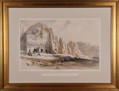
Petra, The Upper or Eastern Valley: 19th C. Hand-colored Roberts Lithograph
By David Roberts
Located in Alamo, CA
This is an original 19th century hand-colored lithograph entitled "Petra, Shewing the Upper or Eastern End of the Valley" by David Roberts, from his Egypt, The Holy Land and Nubia volumes of the large folio edition, published in London by F. G. Moon in 1842. The lithographs were prepared by Louis Haghe (1806-1885) from drawings and paintings by Roberts. The resultant large folio editions of 'The Holy Land' and 'Egypt & Nubia' are considered the greatest lithographically illustrated works issued in the 19th century.
This is one of Roberts' most famous and collectible works. The scene captures a view of the magnificent ruins of Petra in what is Jordan today, as it appeared on March 8, 1839, on the day of Roberts' visit. Multiple Arab men are approaching Petra; some on foot and others riding camels. They are dressed in their colorful local costumes. Roberts' signature and hand written date are reproduced in the plate on the left.
This hand-colored lithograph is printed on wove paper with wide margins. There is some loss of color in the text in the title and a faint dark curvilinear area in the upper right. The print is otherwise in very good condition. It is presented in a gold-colored wood frame with a tan mat. It is glazed with UV protected conservation glass. All framing materials used are archival museum quality. The frame measures 23.5" high and 30.5" wide.
There are two additional iconic David Roberts hand-colored lithographs for sale on 1stdibs that are matted and framed in identical styles, although slightly different sizes. They are scenes of Approach of Simoon, Desert of Gizeh and the Citadel of Cairo. They can be viewed by typing their reference #'s, LU1173211955452 and LU1173211970142, into the 1stdibs search field or typing Timeless Intaglio in the search field and tapping on the drop down name to be taken to our storefront. Two or all three of these pieces would make for a striking display grouping. A discount is available for the purchase of multiple pieces.
David Roberts (1796-1864) was a Scottish painter who specialized in landscapes, architectural subjects, and scenes from the Middle East and Europe. Born in Edinburgh, Roberts began his career at age ten as an apprentice to a house painter and eventually became a scene painter for theater companies in Edinburgh and London. In the 1820s, J. M. W. Turner recognized his artistic talent and encouraged him to become a full-time artist. He began to focus on painting landscapes and architecture. In 1838 he traveled to Egypt and soon after to the Holy Land, concluding in Jerusalem. Roberts' travels in the Middle East had a profound impact on his art, and he produced a series of highly detailed and realistic paintings and sketches of the region's famous ruins and other landmarks, including the Pyramids of Giza, the Sphinx, the Temple of Abu Simbel...
Category
Mid-19th Century Realist Landscape Prints
Materials
Lithograph
$3,575
H 23.5 in W 30.5 in
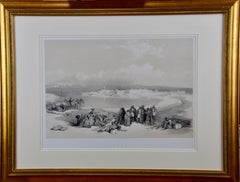
David Roberts' 19th Century Duo-tone Lithograph, "Suez, General View"
By David Roberts
Located in Alamo, CA
"Suez, General View" is a 19th century folio sized tinted duo-tone lithograph, plate 124 from the "The Holy Land, Syria, Idumea, Arabia, Egypt and Nubia" volume of David Roberts’ large folio edition, published in London by F. G. Moon in 1843. The lithographs were prepared by Louis Haghe (1806-1885) from paintings by Roberts. The resultant large folio editions of 'The Holy Land' and 'Egypt & Nubia' are considered the greatest lithographically illustrated works issued in the 19th century. The lithograph depicts the Suez city skyline on a peninsula with boats moored in the bay. Men, dressed in traditional Arab costumes, rest on a hillside In the foreground with their camels, weapons and presumably goods for sale and trade.
This tinted lithograph, which is professionally framed in a decorative gold-colored wood frame with cream-colored double mats. The print is in excellent condition.
There are four additional listings of David Roberts hand colored engravings of Egypt...
Category
1840s Realist Landscape Prints
Materials
Lithograph
$2,375
H 24.63 in W 31.63 in D 1.25 in
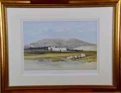
Thebes, Egypt: A Framed 19th Century Hand-colored Lithograph by David Roberts
By David Roberts
Located in Alamo, CA
"Medinet Abou, Thebes" is a 19th century folio sized hand-colored lithograph from the Egypt and Nubia volume of David Roberts’ large folio edition, published in London by F. G. Moon ...
Category
1840s Realist Landscape Prints
Materials
Lithograph
$2,975
H 24.25 in W 32 in D 1.25 in
David Roberts' 19th Century Hand Colored Lithograph, St. Jean D'Acre
By David Roberts
Located in Alamo, CA
"St. Jean D'Acre" is a 19th century folio sized hand-colored lithograph from the "The Holy Land, Syria, Idumea, Arabia, Egypt and Nubia" volume of David Roberts’ large folio edition,...
Category
1840s Realist Landscape Prints
Materials
Lithograph

$2,575
H 24.25 in W 32 in D 1.25 in
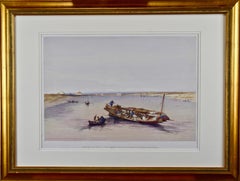
"View Towards the Pyramids": David Roberts' 19th Century Hand Colored Lithograph
By David Roberts
Located in Alamo, CA
"View Towards the Pyramids" is a 19th century full folio sized hand-colored lithograph by David Roberts from his monumental publication "The Holy Land, Syria, Idumea, Arabia, Egypt, and Nubia", published in London in 1846. It depicts a scene of a boat on the Nile, along with several smaller boats. Saccara (Saqqara), near Memphis, the original capital of Egypt, can be seen in the background with its ancient Step Pyramid of Pharoah Djoser. This was the first Egyptian pyramid, designed by the physician and architect Imhotep. Pharoah Snofru’s (Sneferu) failed design Bent Pyramid and the subsequent replacement Red Pyramid can be seen in Dashour (Dashur). These structures preceded the more famous pyramids in Giza.
This lithograph is professionally framed in a gold-colored wood frame, double cream-colored mats and it is glazed with museum quality archival material. The print is in excellent condition.
There are four additional listings of David Roberts engravings of Egypt...
Category
1840s Realist Landscape Prints
Materials
Lithograph
$2,975
H 24.25 in W 32 in D 1.25 in
Le Clocher de St. Nicolas
By Jean-Baptiste-Camille Corot
Located in New York, NY
A very good impression of this scarce lithograph on wove paper. , Printed by Lemercier & Cie, Paris and published by Alfred Robaud. From "Douze Croquis et Dessins Originaux."
Catalo...
Category
1870s Realist Landscape Prints
Materials
Lithograph