Items Similar to Antique 1765 Wine Country Folding Map of France, Bordeau etc.


Want more images or videos?
Request additional images or videos from the seller
1 of 10
UnknownAntique 1765 Wine Country Folding Map of France, Bordeau etc.1765
1765
$1,200
£909.91
€1,043.97
CA$1,707.45
A$1,852.20
CHF 973.99
MX$22,537.54
NOK 12,176.45
SEK 11,483.89
DKK 7,794.60
About the Item
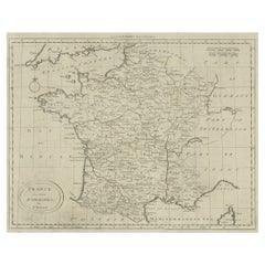
Route du Carosse de Bordeaux, part de Paris tous les Mardis a 11 matin. a et pafse 1765 is a comprehensive map with two routes through the wine country of France starting in Paris going south to Orleans where it splits one way to Bordeaux and the other to Toulouse. Along the way there are suggestions for where to dine, where to sleep, times to leave on the train, etc. . A very detailed folding pocket map for the traveler and wine connoisseur of the day. There are two folds that have been laid flat and are hardly visible. Hand colored etching in very good condition.
- Creation Year:1765
- Dimensions:Height: 21 in (53.34 cm)Width: 10.5 in (26.67 cm)
- Medium:
- Period:1760-1769
- Condition:
- Gallery Location:Paonia, CO
- Reference Number:1stDibs: LU78034022292
About the Seller
4.9
Gold Seller
Premium sellers maintaining a 4.3+ rating and 24-hour response times
Established in 1978
1stDibs seller since 2017
128 sales on 1stDibs
Typical response time: 2 hours
- ShippingRetrieving quote...Shipping from: Paonia, CO
- Return Policy
Authenticity Guarantee
In the unlikely event there’s an issue with an item’s authenticity, contact us within 1 year for a full refund. DetailsMoney-Back Guarantee
If your item is not as described, is damaged in transit, or does not arrive, contact us within 7 days for a full refund. Details24-Hour Cancellation
You have a 24-hour grace period in which to reconsider your purchase, with no questions asked.Vetted Professional Sellers
Our world-class sellers must adhere to strict standards for service and quality, maintaining the integrity of our listings.Price-Match Guarantee
If you find that a seller listed the same item for a lower price elsewhere, we’ll match it.Trusted Global Delivery
Our best-in-class carrier network provides specialized shipping options worldwide, including custom delivery.More From This Seller
View AllMap of Tabula Geographica Territorium Civitatis Svevo=Hallensis by Homann 1762
By Homann Heirs
Located in Paonia, CO
Map of Tabula Geographica sistens Territorium Liberae Sacri Romani Imperi Civitatis Svevo=Hallensis in suas Praefecturas divisum unacum finitimis Regionibus delineata a Mattheo ...
Category
1760s Other Art Style More Prints
Materials
Engraving
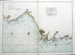
Carte Particuliere Des Coste De Bretagne qui Comprend Morlaix
By Pierre Mortier
Located in Paonia, CO
Carte Particuliere Des Costes De Bretagne qui Comprend Morlaix, Saint Paul de Leon, les Sept Isles, et L’Isle. Faite par ordre Exprez Du Roy de France is from the collection of ch...
Category
1690s Landscape Prints
Materials
Engraving

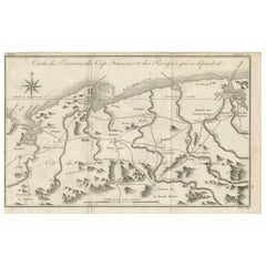
Carte Particular Des Costes De Bretagne Depuis le Cap de Frehel, Jusques a Perros
By Pierre Mortier
Located in Paonia, CO
Carte Particulaire Des Costes De Bretagne Depuis Le Cap de Frehel, Jusques a Perros, & L’Isle Tome. This large sea scale chart shows part of the northwestern co...
Category
1690s Landscape Prints
Materials
Engraving
Persiae, Armeniae, Natoliae et Arabiae Descriptio per Frederick deWit 1666 map
Located in Paonia, CO
Map of Persiae, Armeniae, Natoliae et Arabiae Descriptio per F de Wit 1688 engraving from: Atlas Contractus Orbis Terrarum Praecipuas ac Novissimas Complectens Tabulas. Amsterdam, N. Visscher, 1656-77. (Koeman III, Vis5-8) This highly decorative map of the Middle East is by the Dutch engraver, publisher, and map seller...
Category
1660s Realist Landscape Prints
Materials
Engraving

England Map of the County of Southampton from an Actual Survey
Located in Paonia, CO
Cartographers Christopher (1786-1855) and John (1791-1867) Greenwood were surveyors from Yorkshire, who undertook an ambitious project to produce a series of large-scale maps of the counties of England, Wales and Scotland.The maps represent a remarkable and impressive surveying achievement forming an important record of the counties depicted.
In the years 1817-1832 the Greenwood brothers published the Atlas of The Counties of England from an Actual Survey. This Atlas was finely drafted and engraved and decorated with large vignettes of prominent buildings of the county. This map of Southampton County is beautifully hand colored and is in very good condition. There is a vignette of Winchester Cathedral...
Category
19th Century Other Art Style Landscape Prints
Materials
Engraving

Map of the County of Buckingham From an Actual Survey
Located in Paonia, CO
Cartographers Christopher (1786-1855) and John (1791-1867) Greenwood were surveyors from Yorkshire, who undertook an ambitious project to produce a series of large-scale maps of the counties of England, Wales and Scotland.The maps represent a remarkable and impressive surveying achievement forming an important record of the counties depicted.
In the years 1817-1832 the Greenwood brothers published the Atlas of The Counties of England from an Actual Survey. This Atlas was finely drafted and engraved and decorated with large vignettes of prominent buildings of the county. This map of Buckingham County is beautifully hand colored and is in very good condition. There is a vignette of Stowe House...
Category
19th Century Other Art Style More Prints
Materials
Engraving

You May Also Like
Antique Map of the Environs of Cap-Français, Saint-Domingue, c.1760
Located in Langweer, NL
Antique Map of the Environs of Cap-Français, Saint-Domingue, c.1760
This detailed 18th-century copperplate engraving, titled Carte des Environs du Cap Français et des Paroisses qui ...
Category
Antique Early 18th Century French Maps
Materials
Paper
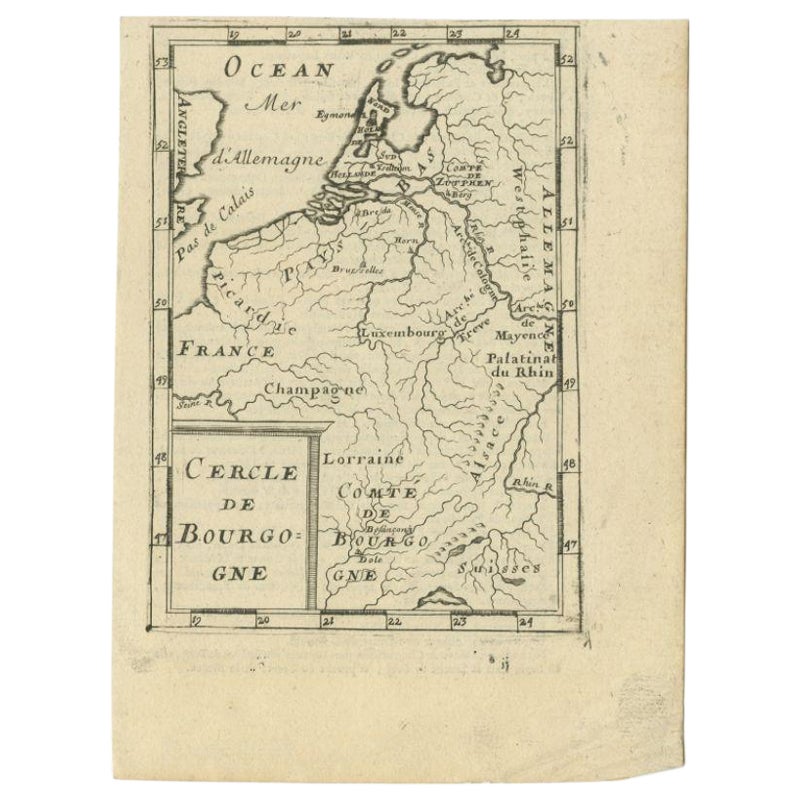
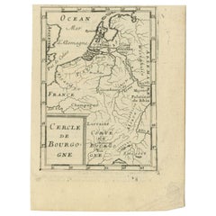
Antique Map of the Burgundy Region by Mallet, c.1683
Located in Langweer, NL
Antique map titled 'Cercle de Bourgogne'. Detailed miniature map of the Burgundy region, France. Also shows the Netherlands and Belgium. Originates from Mallet's 'Description de l'Un...
Category
Antique 17th Century Maps
Materials
Paper
$81 Sale Price
20% Off
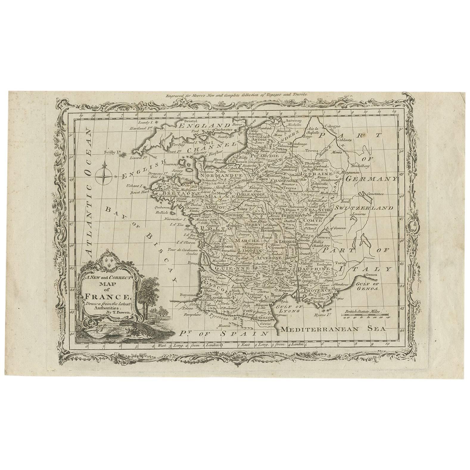
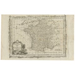
Antique Map of France with the English Channels, 1754
Located in Langweer, NL
Antique map France titled 'An Accurate Map of France drawn from the best authorities'. Small, detailed map of France. With decorative title cartouche.
Ar...
Category
Antique 18th Century Maps
Materials
Paper

$239 Sale Price
20% Off
Martinique Map by Rigobert Bonne – French Antique Map, c.1768
Located in Langweer, NL
Map of Martinique by Rigobert Bonne, circa 1768
This is a detailed antique map of Martinique titled “Isle de la Martinique,” engraved by Rigobert Bonne around 1768 for the Atlas Encyclopédique. Bonne, a renowned French hydrographer and successor to Bellin, is celebrated for his scientifically precise and elegantly engraved maps.
The map shows Martinique with its mountainous interior, rivers, and settlements labelled, including Fort Royal, Fort St. Pierre, Le Marin, and Le Prêcheur. Coastal features, bays, and capes are marked, along with anchorages important for maritime navigation in the 18th century. The depiction includes relief shown pictorially, characteristic of Bonne’s cartographic style, enhancing both geographic understanding and aesthetic appeal.
This copperplate engraving retains original hand colouring outlining the coastlines in delicate blue and brown tones, typical for the period. It served as a key reference for scholars, navigators, and colonial administrators during France’s colonial presence in the Caribbean.
Condition:
Good condition overall. A strong impression with bright, original hand-colour outlines. General age toning, faint offsetting, and a vertical fold as issued in the atlas. Margins ample all around for framing.
Framing suggestions:
This historic Caribbean map...
Category
Antique 1760s French Maps
Materials
Paper

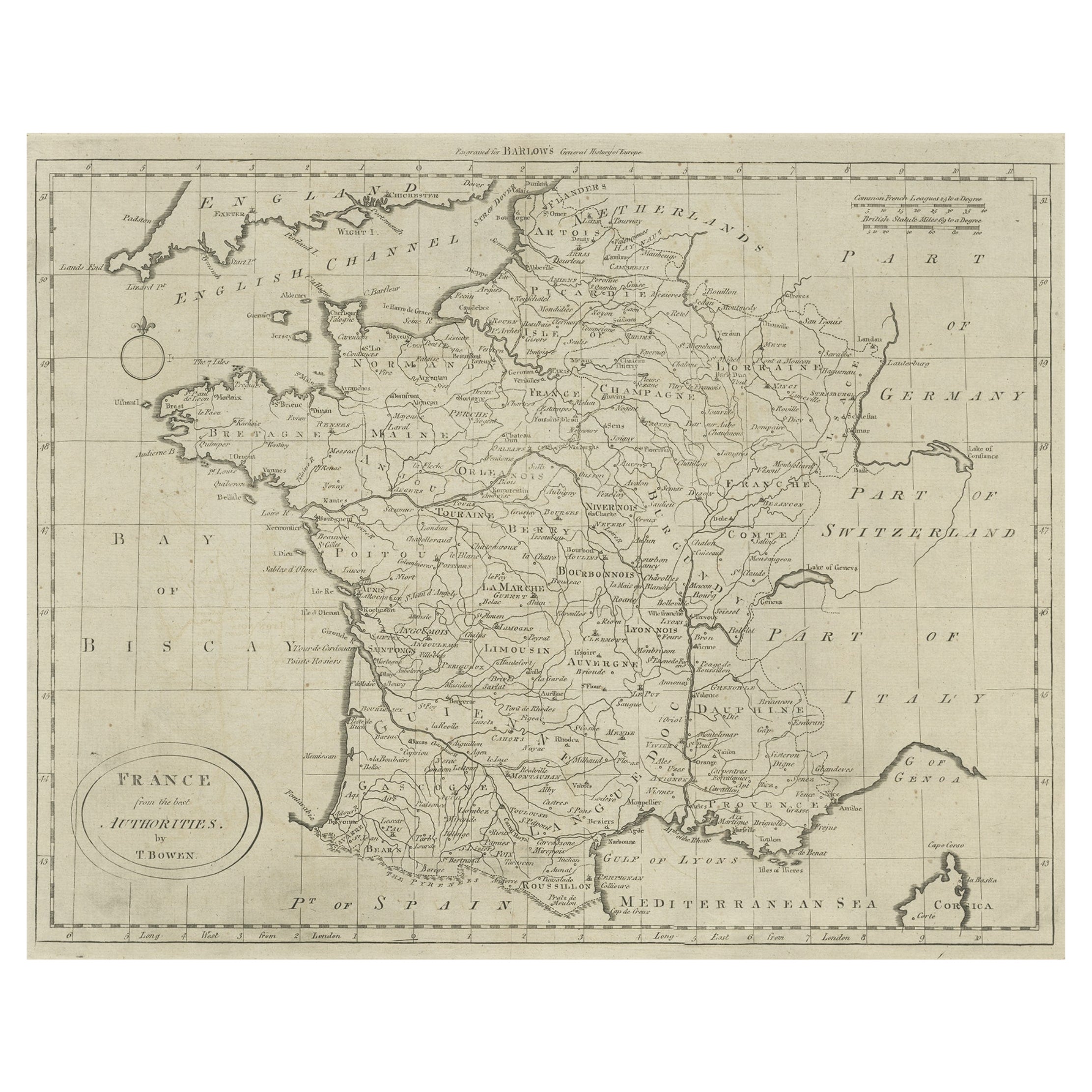
Antique Map of France by T. Bowen, 1785
Located in Langweer, NL
Decorative antique map of France titled 'A new and accurate map of France, Drawn from the latest Authorities by T. Bowen'. Engraved for Moore’s new and complete collection of Voyages...
Category
Antique Late 18th Century Maps
Materials
Paper
$153 Sale Price
20% Off
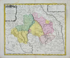
Antique Map of France by Bowen, c.1790
Located in Langweer, NL
Antique map titled 'France from the best Authorities'. Original antique map of France. Engraved for Barlow's General history of Europe. Published circa 1790.
Artists and Engraver...
Category
Antique 18th Century Maps
Materials
Paper
$325 Sale Price
20% Off