Items Similar to 1939 original map Lucien Boucher Crédit Lyonnais Afrique Du Nord Union Française


Want more images or videos?
Request additional images or videos from the seller
1 of 7
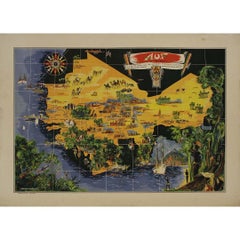
Lucien Boucher1939 original map Lucien Boucher Crédit Lyonnais Afrique Du Nord Union Française1939
1939
$2,147.24
£1,587.48
€1,800
CA$2,953.50
A$3,283
CHF 1,720.88
MX$40,093.31
NOK 21,484.14
SEK 20,212.57
DKK 13,703.37
About the Item
The 1939 original map by Lucien Boucher, commissioned by Crédit Lyonnais, is a remarkable piece of cartographic art that highlights the regions of North Africa within the French Union. This map, designed in the distinctive style of Boucher, known for his detailed and decorative maps, showcases the colonial territories of the French Empire in North Africa, emphasizing the economic and cultural links fostered by Crédit Lyonnais. The map features intricate illustrations of landscapes, people, and key landmarks, reflecting the colonial perspective and the economic ambitions of France in the region. Produced on the eve of World War II, it captures a significant period in history when colonial empires were at their peak. Lucien Boucher's work is not just a map but a piece of propaganda, promoting the idea of a unified and prosperous French Union in Africa, underpinned by the financial stability provided by institutions like Crédit Lyonnais. This map is a fascinating artifact, offering insights into the colonial mindset and the geopolitical dynamics of the late 1930s.
- Creator:Lucien Boucher (1889 - 1971, French)
- Creation Year:1939
- Dimensions:Height: 41.34 in (105 cm)Width: 29.93 in (76 cm)
- Medium:
- Period:
- Condition:Good condition, pin holes.
- Gallery Location:PARIS, FR
- Reference Number:1stDibs: LU1792214831892
Lucien Boucher
1889 - 1971 Known by Air France as Mr. Planosphere, he created these designs between 1934 - 1962. Beginning around 1935, Lucien Boucher designed an impressive stream of posters for Air France that continued until he was well into his seventies. [PAI-XXII, 220] This artist is known mainly for a series of absorbing Air France world map posters that signal a global theatre. Lucien Boucher launched his design career tuned to the commercial promise of Surrealism. Born in Chartre, he studied at the École de Céramique de Sèvres. He debuted at the Salon d'Automne in 1921, becoming a member in 1923; he also exhibited at the Salon de l'Araignée from 1924-1930. Boucher also made wood engravings, drawings in watercolor and gouache, and lithographs. Lucien Boucher's witty and charming color lithographs Lucien Boucher launched his design career at the Ceramique de Sevres and made his debut at the Salon d'Automne in 1921, becoming a member in 1923: he also exhibited at the Salon de L'Araignée from 1924-1930. Besides lithographs, Boucher also created wood engravings and drawings in watercolor. Beginning around 1935, Boucher designed an impressive series of posters for Air France that he continued producing until he was well into his seventies. Boucher is known mainly for his absorbing Air France poster designs, known as "Monsieur Planisphere" (planispheres are flattened representations of planet Earth). He created a variety of illustrated World Maps that depicted the global flight routes serviced by the airline.
About the Seller
5.0
Gold Seller
Premium sellers maintaining a 4.3+ rating and 24-hour response times
Established in 2021
1stDibs seller since 2022
171 sales on 1stDibs
Typical response time: 1 hour
- ShippingRetrieving quote...Shipping from: PARIS, France
- Return Policy
Authenticity Guarantee
In the unlikely event there’s an issue with an item’s authenticity, contact us within 1 year for a full refund. DetailsMoney-Back Guarantee
If your item is not as described, is damaged in transit, or does not arrive, contact us within 7 days for a full refund. Details24-Hour Cancellation
You have a 24-hour grace period in which to reconsider your purchase, with no questions asked.Vetted Professional Sellers
Our world-class sellers must adhere to strict standards for service and quality, maintaining the integrity of our listings.Price-Match Guarantee
If you find that a seller listed the same item for a lower price elsewhere, we’ll match it.Trusted Global Delivery
Our best-in-class carrier network provides specialized shipping options worldwide, including custom delivery.More From This Seller
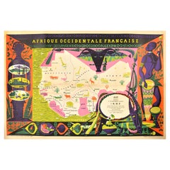
View AllOriginal map poster by G. Carriat Rolant for AOF (Afrique Occidentale Française)
Located in PARIS, FR
The circa 1950 original map poster by G. Carriat Rolant for AOF (Afrique Occidentale Française) is a notable example of mid-20th-century cartographic art and colonial-era representation. Numbered 584 out of 1000, this limited-edition piece was edited by Paul Bory...
Category
1950s Prints and Multiples
Materials
Lithograph, Paper
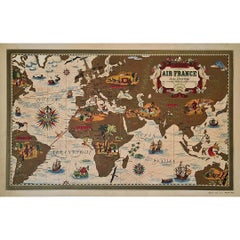
1937 Original planisphere by Lucien boucher - World map
By Lucien Boucher
Located in PARIS, FR
Original poster
Airline Company - Map - Tourism
West - Northern - Orient - Midi
In 1937, Lucien Boucher, a renowned French illustrator, unveiled his masterpiece, the "Planisphère ...
Category
1930s Prints and Multiples
Materials
Linen, Lithograph, Paper
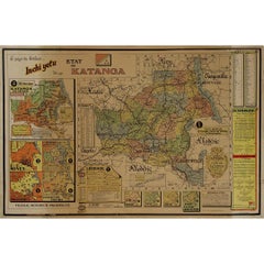
Original 1960 Map by Louis Dressen État du Katanga Congo
Located in PARIS, FR
This original 1960 poster by Louis Dressen, titled État du Katanga, is a rare and powerful visual document from one of the most turbulent moments in post-colonial African history. Pu...
Category
1960s Prints and Multiples
Materials
Paper, Lithograph
1939 original map for Air France titled "Nova et Vetera" by Lucien Boucher
By Lucien Boucher
Located in PARIS, FR
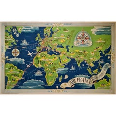
In 1939, Lucien Boucher, a renowned French artist and illustrator, created a captivating map for Air France titled "Nova et Vetera", which translates to "New and Old" in Latin. This original lithographic poster is a remarkable fusion of vintage cartographic art and modern aviation, crafted as a promotional piece for the airline. It beautifully symbolizes the connection between the historic routes of exploration and the new ones made possible by air travel.
Boucher was celebrated for his unique ability to combine the romanticism of classic maps with the sleek, modern spirit of 20th-century flight. Among his series of illustrated maps for Air France, "Nova et Vetera" stands out with its nostalgic allure and references to history.
The map exudes the charm of the age of exploration, echoing the style of 16th- and 17th-century cartographers. Rendered in rich, earthy tones, it depicts brown continents framed by pale blue oceans, evoking the feel of antique navigational...
Category
1930s Prints and Multiples
Materials
Lithograph, Paper, Linen
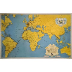
1938 original map titled "Carte du réseau aérien français" Air France
Located in PARIS, FR
The 1938 original map titled "Carte du réseau aérien français" by A. Collinet offers a captivating snapshot of Air France's global aviation network durin...
Category
1930s Prints and Multiples
Materials
Linen, Paper, Lithograph
Jacques Liozu's 1951 illustrated map of South America
By Jacques Liozu
Located in PARIS, FR
Jacques Liozu's 1951 illustrated map of South America is an exceptional work of cartography that skilfully blends art and geography. French artist and cartographer Jacques Liozu crea...
Category
1950s Prints and Multiples
Materials
Lithograph, Paper

You May Also Like
Original Vintage Poster French West Africa Map Afrique Occidentale Francaise Art
By alain cornic
Located in London, GB
Original vintage poster featuring an illustrated map of French West Africa / Afrique Occidentale Francaise marking the capital cities, towns, ports, Sahara Desert and rivers in Mauri...
Category
Vintage 1950s French Posters
Materials
Paper
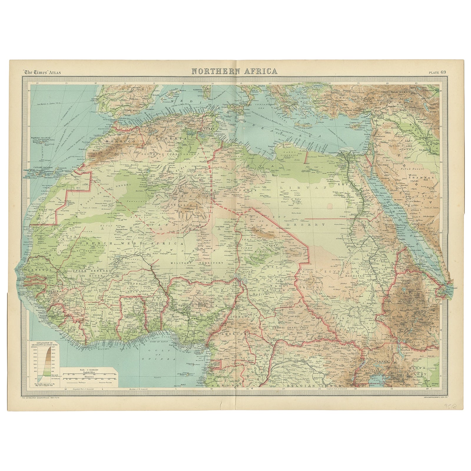
Old Map of North Africa Depicting Libya, Morocco, Algeria, Tunis Etc, 1922
Located in Langweer, NL
Antique map of Africa titled 'Northern Africa'.
Old map of North Africa depicting Libya, Morocco, Algeria, Tunis and surroundings. This map originates from 'The Times' atlas.
...
Category
Vintage 1920s Maps
Materials
Paper
$114 Sale Price
20% Off
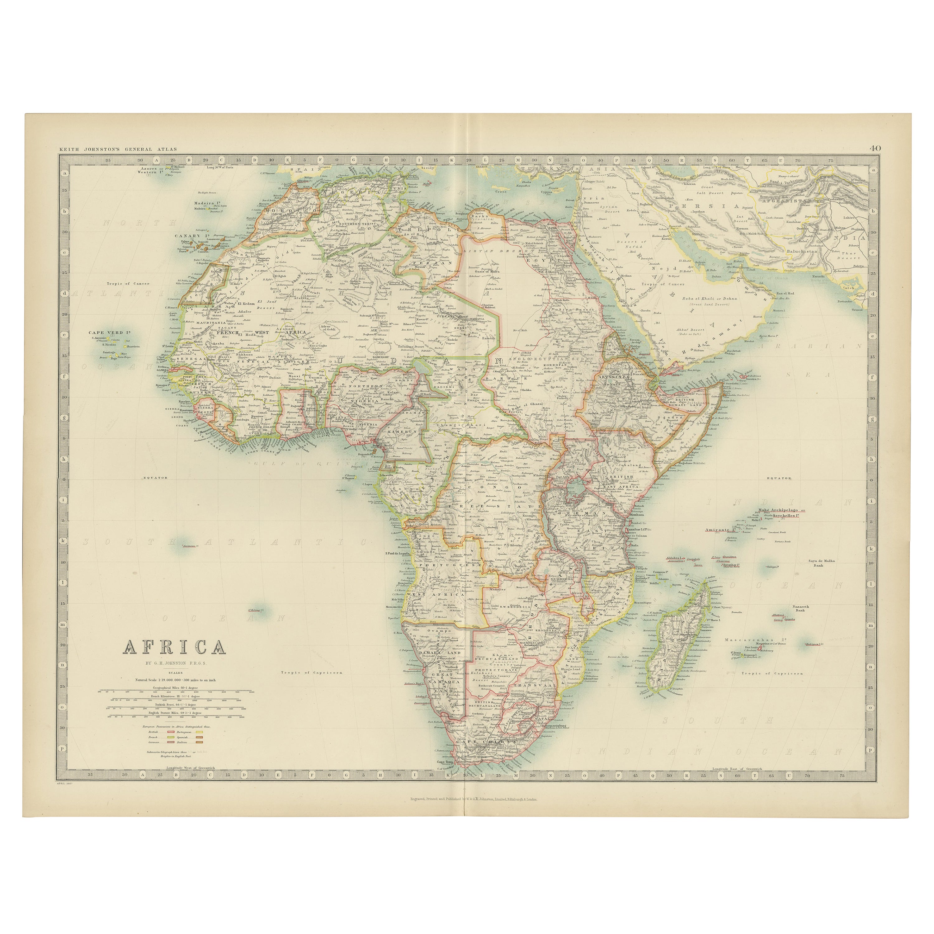
Antique Map of Northwest Africa by Bartholomew, 1922
Located in Langweer, NL
Antique map of Africa titled 'North-West Africa'. Old map of north-west Africa depicting Morocco, Algeria, Tunis and surroundings. This map originates from 'The Times' atlas. Artists...
Category
20th Century Maps
Materials
Paper
$90 Sale Price
20% Off
Antique Map of Africa by Johnston (1909)
Located in Langweer, NL
Antique map titled 'Africa'. Original antique map of Africa. This map originates from the ‘Royal Atlas of Modern Geography’. Published by W. & A....
Category
Early 20th Century Maps
Materials
Paper

$238 Sale Price
20% Off
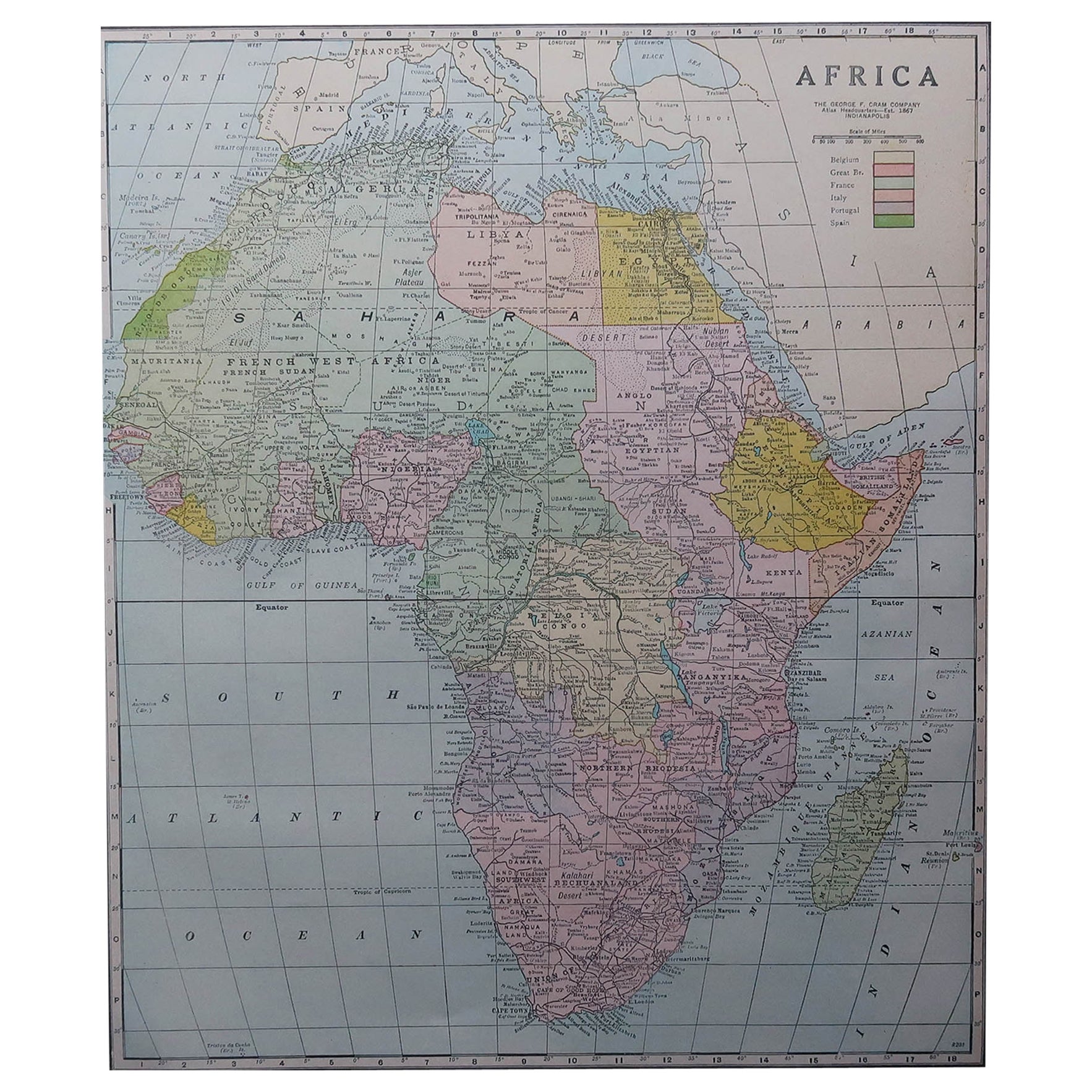
Large Original Antique Map of Africa. C.1900
Located in St Annes, Lancashire
Fabulous map of Africa
Original color.
Engraved and printed by the George F. Cram Company, Indianapolis.
Published, C.1900.
Unframed.
Free shipping.
Category
Antique 1890s American Maps
Materials
Paper

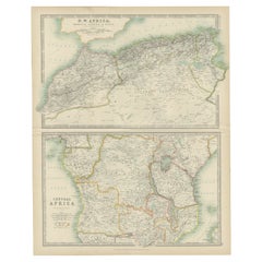
Antique Map of N.W. Africa & Central Africa by Johnston (1909)
Located in Langweer, NL
Antique map titled 'N.W. Africa & Central Africa'. Original antique map of N.W. Africa & Central Africa. This map originates from the ‘Royal Atlas of Modern Geography’. Published by ...
Category
Early 20th Century Maps
Materials
Paper
$238 Sale Price
20% Off
More Ways To Browse
Vintage Style World Map
World War Ii Propaganda
Vintage African Map
Vintage Country Flags
William Vincent
African American Charcoal
Hitler Signed
Leather Folder
Oversized Poster
18th Century African Art
Andy Warhol Castelli
Antique Cemetery
Bernard Buffet Lithograph Signed
Bird Woman Sculpture
Cambridge Map
Homage To Chagall
Jerusalem Engraving
Obey Giant